Finally, a Winter Escape (not an escape into Winter)
Hiking: Golden-Gower Loop, Skidoo Mine Area, Cyty's Mill and Big Bell Extension Mine,
Rogers Peak, Certainly Lost Desert Hound Mine, and Desolation Canyon
Biking: Badwater from Furnace Creek Campground

|
| |||||


|
| |||||


|
| |||||


|
| |||||


| ||||
| ||||

“It’s a dangerous business, Frodo, going out your door. You step onto the
road, and if you don’t keep your feet, there’s no knowing where you might be swept off to.” Bilbo Baggins
.
Camera: Panasonic DMC-ZS19 (bike), ZS60 (hike)
Maps: I have included maps for each of the hikes featured in this Escape. For general purpose, here is a scan of part of the NPS park map.
| ||||
ERM = Energy Required Miles. A mile is added for
every 500' elevation gain or
loss. It's a very serviceable method of estimating energy required miles. ERM was initially used in Trails
of the Tetons (long out of print) by Paul Petzold, founder of NOLS. It's a wonderfully useful concept and
application. Add one mile for each 500' up AND down to distance = ERM. I use ERMs to calculate what the actual
day is like. It's a very serviceable method of estimating energy required miles. Remember, however, that the
ERMs are estimates because they depend on GPS satellite coverage and math functions.
Using ERMs does not account for the 'texture' of the route or trail - that
is, rocky, boulders, no trail, slimy mud, etc., yet does help approximate the route.
Photos from Day 1, Death Valley 2020
 |
 |
Day 1.
Dropping down from the Colorado Plateau, I go from Winter to
what feels like early Summer or at least Spring at Death Valley (DV). And I wonder, "how long will this last?
Will it be like last year, an escape into Winter?" By evening, the venerable VE-24 tent and I will be back into
Winter, with 30 MPH wind gusts attempting to turn tents into box kites, a cold front chilling the air.
I'm the first to arrive in DV. Rob P. arrives and we chat about numerous
trips past. Rob shows off the new (to him) bike that he purchased on the way to DV. It looks terrific and in
better condition than my venerable Trek 700, now approaching 40 years old.
During the night, there were intermittent periods of calm, punctuated
by flailing winds.
The full moon pierces the cloud cover at times. It's quiet and dust-free
inside the VE-24 (solid tent fabric - no mesh), and I sleep well.
Photos from Day 2, Death Valley 2020
 |
 |
 |
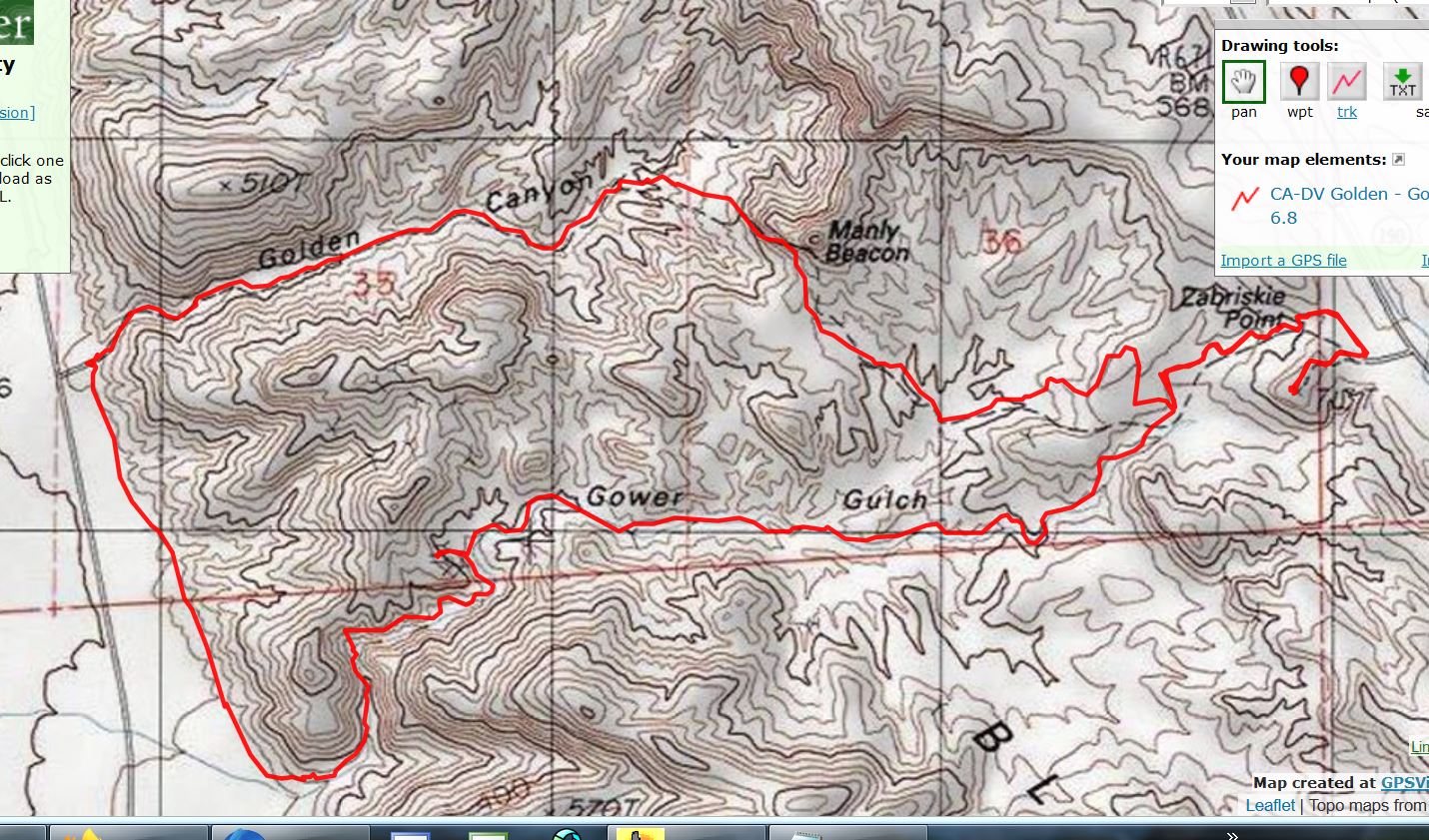
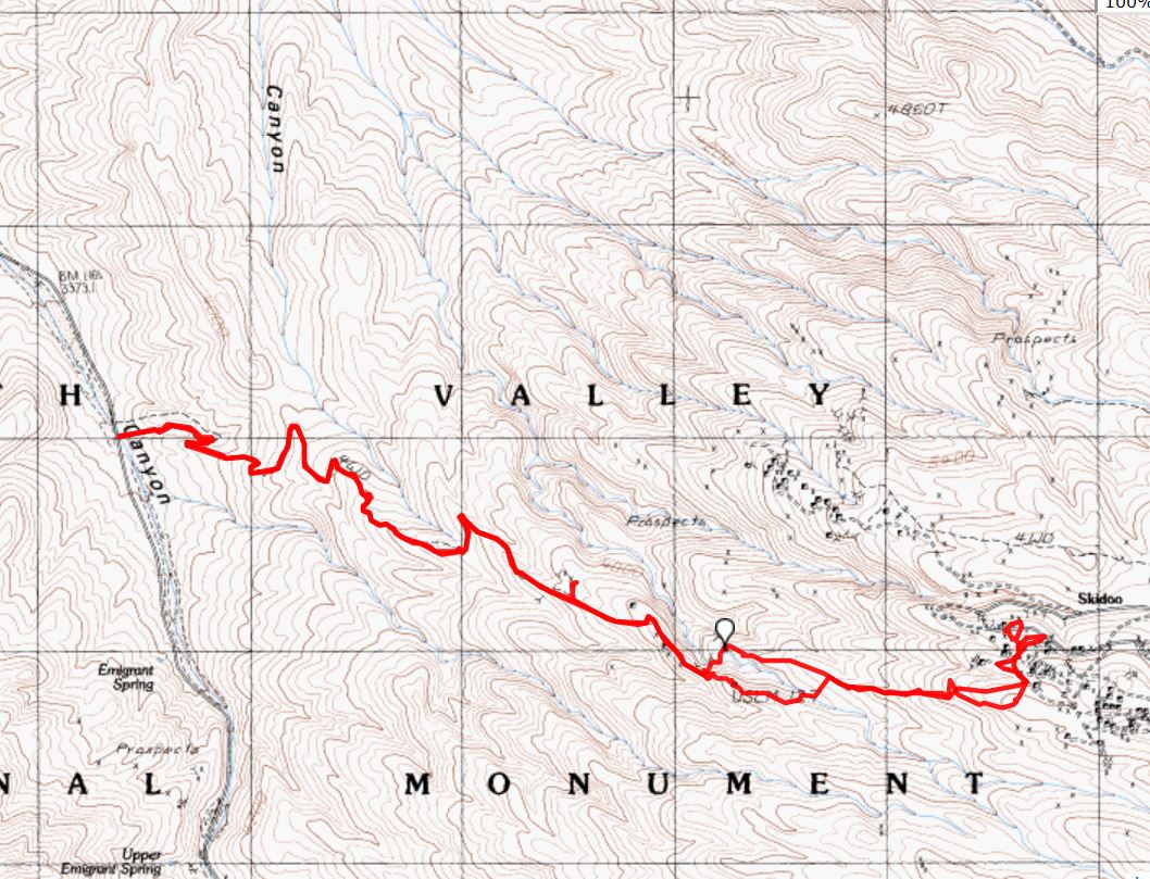
Day 2: Golden-Gower Loopo, with wind. 7 miles. ERM of 11. Hike.
Map of the hike around the Golden-Gower loop (click) -pdf file
Here's another, very similar yet smaller file, version of the Golden-Gower map - jpg file
The gust rips off my hat, wrapping the strap around my ear, and
attempts to sail it to Manly Beacon. Well, it is forecast as a 50 MPH wind advisory day. Yikes.
I can hear Rob P. talking. Perhaps I see only his mouth moving and
imagine he's talking? Yet it's difficult to understand him as his voice flies away with the gale.
We're hiking the Golden-Gower loop, with a leg up to Zabriskie Point.
The unpleasant weather has thinned the crowds and it's pleasant (except for the hurricane, of course). It's way
too windy to attempt a bike ride today.
Finding what appears to be a nook sheltered from the wind tunneling up
Glower Gulch, Rob and I settle in for a lounging lunch. This is a good plan until the wind changes direction. Rob's
socks sail past, closely followed by mine.
Back at camp, we start in to an early happy hour, shielded in the lee of
the wind behind Rob's vehicle.
Later, Randy and Cheryl and others arrive and happy hour is moved to
site 70, where Randy has a fire going. It's good to see some of the bikers and hikers only seen at this Winter Escape.
The fire and social niceties feel good tonight. Because the group (Wasatch Mountain Club; Minnesota Rovers)
members are so spread out, we experience a disjointed social experience this trip. Mostly, I miss the happy hours
all week because I'm out hiking way past closing time for the get togethers. Sigh.
Dinner is simple, meeting the needs of this windy day. More complicated
fare would no doubt result in sand sandwiches and such. Argh.
Photos from Day 3, Death Valley 2020
 |
 |
 |
 |
 |
 |
Day 3: Sporting Skidoo Sorte. 10 miles, ERM = 20.
Map of the hike to the Skidoo Mine area (click) -pdf file
Here's another, very similar yet smaller file, version of the Skidoo map - jpg file
The "obvious track" isn't. Rob P and I decide it's the sporting route.
We have walked the old mining routes up to Saddle Rock Mine and continued up some more. At Saddle Rock,
we poke into an adit along curving ore car rails that disappear around a corner and into the moody darkness.
Fearing a trumpian shafting (like the destruction of services and soaring deficit because of tax cuts for the rich),
we back out and continue to the end of the Saddle Rock old road, and start searching for the obvious route
linking these mines to Skidoo.
Note: Yes, there's a way to get to Skidoo via dirt road. We're not
on this route.
The track is reputed to dip through a drainage and pop up on a bump,
where the "obvious route" ridges to Skidoo. Not seeing the route, we contour on rough terrain, side-hilling and
rock walking, then down to the drainage and up onto the route, which we see intermittently, losing it as we approach
5600' (we started at about 3400') and the broadly scattered Skidoo complex. At times it's slow going and Rob P
wonders aloud how much more we can explore and still return to the Subie Subaru before dark? I too wonder.
Yet, it's bound to be just over the next bump, right?
Wow, we made it. The ripping wind is still with us, and cold. There's
snow in the shade of the ore hopper. It's difficult to find a lunch spot where the internal body temperature will
stay above 80F, even when sporting five layers of clothing. Yikes. In the lee of a rock wall holding back mine tailings,
we find a suitable place. Rob and I are enjoying our solitude-filled day and enjoy good discussions during our 'all
cloths on' lunch. Rob relates a recounting of his self-contained bike tour through the Idaho rail tunnels and
Montana territory. Sounds delightful.
Searching for the Quartz Mill, we range about Skidoo, running out of time
before finding the mill. The mill is most likely over the edge and not possible to see from here. Later, we wonder if
the mill is gone because we scan the hillsides on the way down the route and we see nothing.
Now, it's down the track, easily finding the way this time. And down the
historic (closed to vehicles) mine roads and into local sunset at the car.
We're back to camp in time to cook dinner before sunset. The goose egg
moon brilliantly adorns the sky before bedtime, partially washing out Orion and the other glowing constellations.
| ||||

Photos from Day 4, Death Valley 2020
 |
 |
 |
 |
 |
 |
 |
 |
 |
 |
 |
 |
 |
 |
 |
 |
 |
 |
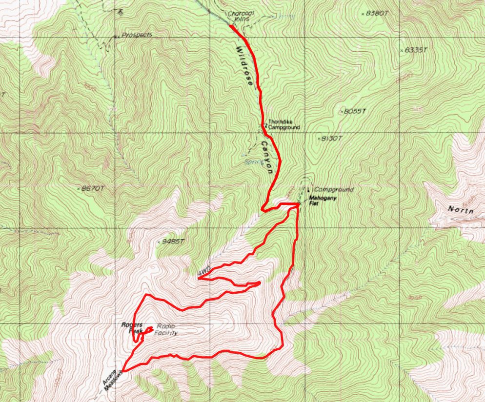
Day 4: Skyward Cyty's Mill. 7.5 miles, ERM = 16.
Map of the hike to the Cyty's Mill and Big Bell Extension Mine (click) -pdf file, large file
Here's another, smaller file, map of the Cyty's Mill hike - jpg file
The odor of Yellowstone wafts past as I poke around Keane Wonder Spring at the foot of the Funeral Mountains. Travertine terraces stairstep from the springs. Hydrogen Sulfide. A warning sign predicts early death if one enters the now covered shaft. The springs are forming travertine as the water sluices toward the basin. Calcium Carbonate.
Hydrogen sulfide is the chemical compound with the formula H2S.
It is a colorless chalcogen hydride gas with the characteristic foul odor of rotten eggs. It is very poisonous,
corrosive, and flammable.
The chalcogens are the chemical elements in group 16 of the periodic table.
This group is also known as the oxygen family. It consists of the elements oxygen, sulfur, selenium, tellurium, and
the radioactive element polonium.
Sulfur rules today at Keane Wonder Spring.
Travertine is a form of limestone deposited by mineral springs, especially hot springs. Travertine often has a fibrous or concentric appearance and exists in white, tan, cream-colored, and even rusty varieties. It is formed by a process of rapid precipitation of calcium carbonate, often at the mouth of a hot spring or in a limestone cave.
Deep pools (abandoned shafts?) and a well glow a saturated green
along the Keane Wonder Fault, which runs for miles at the base of the Funeral Mountains.
I'm hiking solo to Cyty's Mill, then up and up to the Big Bell Extension
Mine. This hike shares a trailhead with the much more popular Keane Wonder Mine. It will be a solitude-filled
track rising 2,000 feet above the mill. The vague description in my book suggests that the hiker try to find the
track to the Big Bell on the bench above Cyty's Mill. I wander a bit, heading for what appears to be a nick in the
escarpment. Once on the at first faint track, it's a fairly steep plod to the ridge crest, followed by a roll to a few
adits and the single adit Big Bell Extension, which after the grunt of effort is disappointing. The unmarked track
is easy to lose as it climbs from the support timber of the mill. Once on the bench above, it becomes more obvious.
The climb through colorful metamorphic rocks and quartz doesn't disappoint, however, because the vistas are
tremendous and the glittering schist and gneiss and such are gorgeous.
On the way back to the car, I see a Coyote trotting my way. The
Song Dog maintains her course. She is nearby and seems unfazed that I am in her general track. She gives
me a canine eye roll as she parallels my route, then drifts over after passing me and onto the track, walking
directly on my tracks. Maybe she's a teenage Coyote? Eye rolling? Deluxe.
Returning to camp, the omnipresent wind has diminished, giving me
time for a shower while nestled in my Australian Pine nook and a brief laundry.
Billions and billions of stars blaze prior to the arrival of the star-busting moon.
The Australian pine, Casuarina equisetifolia, is a deciduous tree with a wispy pine-like appearance that can grow up to 100 feet in height. It looks a bit like the invasive Tamarisk of the Southwest. Even though it is not an actual conifer (Pinus sp.) it has cone-like fruit and leaves that resemble pine needles. Its flowers are tiny, brown and wind-pollinated. The fruit is a nutlet that is about .5 inch in diameter and it contains the winged seeds. This invasive is a fast growing tree that changes habitat, outcompetes native species, and contributes to soil erosion. Dense thickets displaces native vegetation by changing the light, temperature, soil chemistry and hydrology of the habitat. The leaf litter has allelopathic properties, while it covers the ground it inhibits the growth of other plants. The pollen causes strong respiratory allergic reactions. This tree offers no wildlife habitat. It does provide some of the very limited shade in the Furnace Creek area.
| ||||
Photos from Day 5, Death Valley 2020
 |
 |
 |
 |
 |
 |
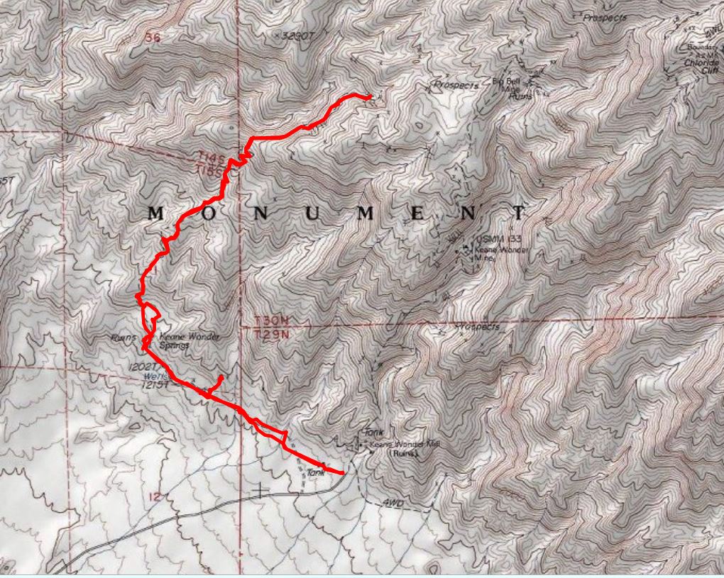
Day 5: Jumping Up to 10,000'. To Rogers Peak. 8.6 miles, ERM = 21.
Map of the hike to Rogers Peak (click) -pdf file, large file
Here's another, smaller file, map of the Rogers Peak hike - jpg file
The snow squeals as the spikes rupture its delicate skin,
and twist a bit. Kahtoola Microspikes. "Sqwuak!" I'm on the way down from Rogers Peak, wind
buffets and narrow plates of snow break loose and clatter down the fall line, sliding off the snow-covered
roadway. Not a smart choice, descending via the communication access road, because its covered by
a 45° angle bank of blown snow. Mostly, it's an angled hard pack and difficult on the ankles, feet, and
knees. And tedious. Other times, the snow is unconsolidated, and post-holing happens. Argh. I'm
wondering how come I ignored my advice to descend via the sun-cleared trail. "Take my advice - I'm
not using it" said every repulsican president in the past 20 years.
On the way up to Rogers, I boot hiked (no spikes) the entire
distance to the summit, now adorned by a bristle of military and domestic antennae and microwaves,
finding the trail leg around Rogers to be baked free of snow.
The wind sets in as I approach the summit, so I find a warm
lunch spot in the lee of an Airforce building. I dream briefly of reusable hand warmers.
Today's vista includes the long view to the Sierra Range.
Gorgeous. The other direction is the dizzying drop to the sub-sea level basin of Badwater. I jump up
on the summit to get to the 10,000' mark, or so I imagine. I'm over 3,000' above the Winter trailhead
of the charcoal kilns and over 10,000' above Badwater, I muse. It's the best sort of getting high.
It's a day of solitude because I see no one between leaving
and returning to the TH.
Back to camp at dark, for dinner and a bucket bath, followed
by an earned collapse into the venerable VE-24.
Reusable hand warmers start with the sodium acetate trihydrate solution in the liquid state. (Food grade solution.) To get to the liquid state, the hand warmers were boiled to ensure the solution was raised above its boiling point of 136.4 °F/58 °C (to 137.12 °F/58.4 °C). The solution must be heated well above its melting point to become a supersaturated solution.
Photos from Day 6, Death Valley 2020
 |
 |
 |
 |
 |
 |
 |
 |
 |
 |
 |
 |
Day 6: Bucolic Badwater. Bike ride to Badwater. 36 miles.
The long ridge of the Panamint Range, which includes Telescope, Bennett,
and, Rogers Peaks, looms over us bikers from Furnace Creek camp as we lilt toward bodacious Badwater, lowest point
in this state, which also includes the high point of the continental U.S. (Mt. Whitney; 14,505'). Yowee, it's a gorgeous day
and the wind is mostly absent.
Yesterday, I muse, I was up there near 10,000'. Today, I'm drifting below sea
level. And, it's warm, with good company, as Rob P, Greg L, Cheryl S, I, and others exchange pleasantries and position,
rolling the tarmac to Badwater.
It's a gorgeous view of the Badwater salt flats, topped by a "sea level" sign
far above on the hillside.
Unbelievably, the ride back is accompanied by a faint tailwind. Wowee. I
stop at the Alien or Toadstool Rock for lunch because it's only a few miles from the downhill to camp. Best Badwater ride ever.
After a lovely hot shower in a nook within the Australian Pines, an invasive
akin to the dreadful tamarisk, I sit and write some of these notes. This is followed by happy hour among the
remaining WMCers. (Wasatch Mountain Club - WMC.)
Photos from Day 7, Death Valley 2020
 |
 |
 |
 |
 |
 |
 |
 |
 |
 |
 |
 |
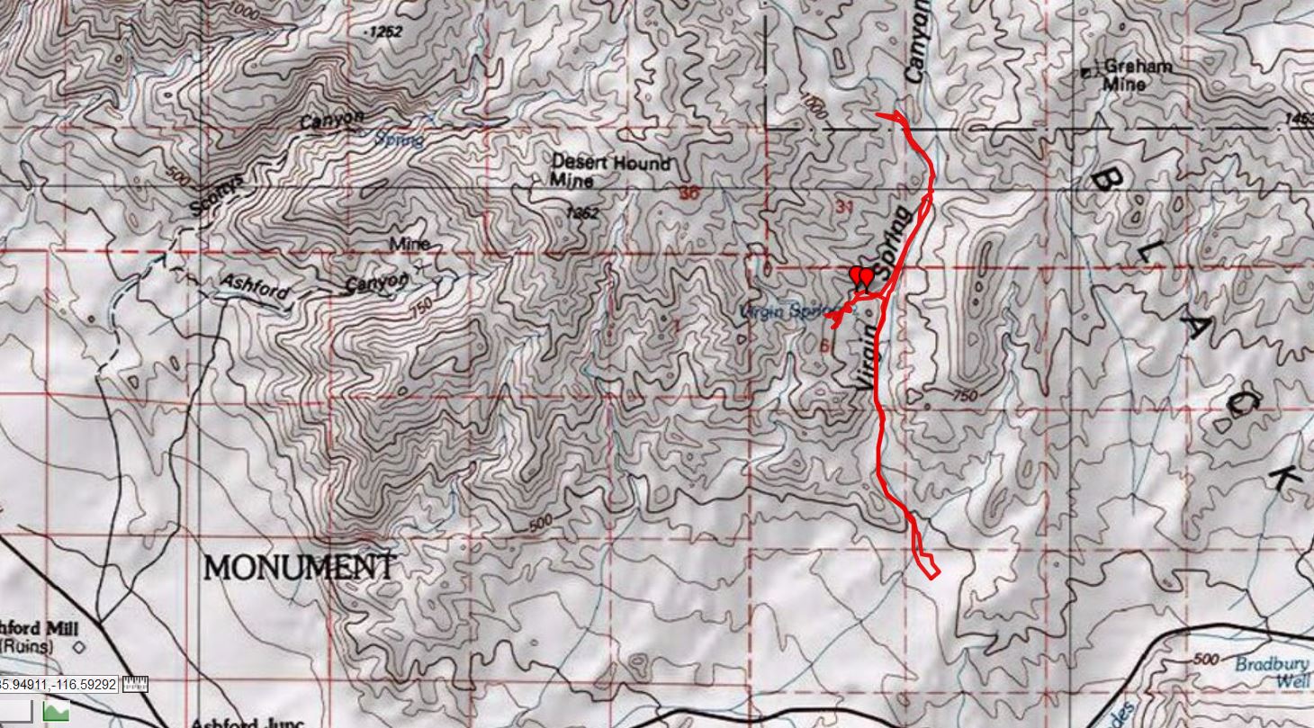
Day 7: Lost Desert Hound Downer. Hunt for the Desert Hound Mine and Trails. 9.4 miles, ERM = 16.
Map of the hike toward Desert Hound (click) -pdf file, large file
Here's another, smaller file, map of the Desert Hound hike - jpg file
The day starts with superb reflections of the Panamint Range in tiny pools of super
saturated salt flats water. Gorgeous.
Bumping up the wash in the Subie Subaru, Greg L. and I begin the quest for the
Desert Hound Mine. Soon (1.2 miles in from the highway) we begin hiking the wash of Virgin Spring Canyon.
Greg L. and I have scoured the hillside of jagged rocks above the Virgin Spring,
looking for the trace of a trail to the Desert Hound Mine, without success. We retreat into the drainage and there find the
footing for the stamp mill which is the key to locating the trace of a track. By now it's lunch time and besides, the trace goes
very sharply up and promises to be a difficult and disappearing route.
So, Greg spies a shade producing boulder where we eat lunch, then decide to hike
up the main wash, Virgin Spring Canyon, to the rock house ruins. It's just too late in the day to contemplate the trace of a
track to the Desert Hound, or much of anything else.
Wandering the wash, we encounter an empty carapace from a young Desert
Tortoise. We chat about what might have happened to the inhabitant of the carapace, perhaps a Raven or Coyote had
it for a snack?
The stone ruins are reputed to be among the largest in DV. The largest is cleverly
situated with one wall being a yuge boulder. The chimney brick work looks good, standing the test of time. Greg and I talk
about what "among the largest stone ruins" might mean because these old mine operation buildings were not large, not really.
Wondering where the Desert Hound Trail loops around from the mine (the trace
of a track goes in from the ridge route), we continue up canyon, then quit. There's not much to go on to aide navigation.
Could this be the best way to the Lost Desert Hound Mine? It will stay lost, we admit as we crunch down the colluvium
toward the car. We lounge in folding chairs awhile in the shade of the Subie Subaru and contemplate the natural quiet
that is the wild areas of DV (except when the military planes shatter the quiet, that is).
Greg and I return to a quick dinner and a pleasant rundown of the day with Rob P.
Colluvium is a general name for loose, unconsolidated sediments that have been deposited at the base of hillslopes by either rainwash, sheetwash, slow continuous downslope creep, or a variable combination of these processes.
Photos from Day 8, Death Valley 2020
 |
 |
 |
 |
 |
 |
 |
 |
 |
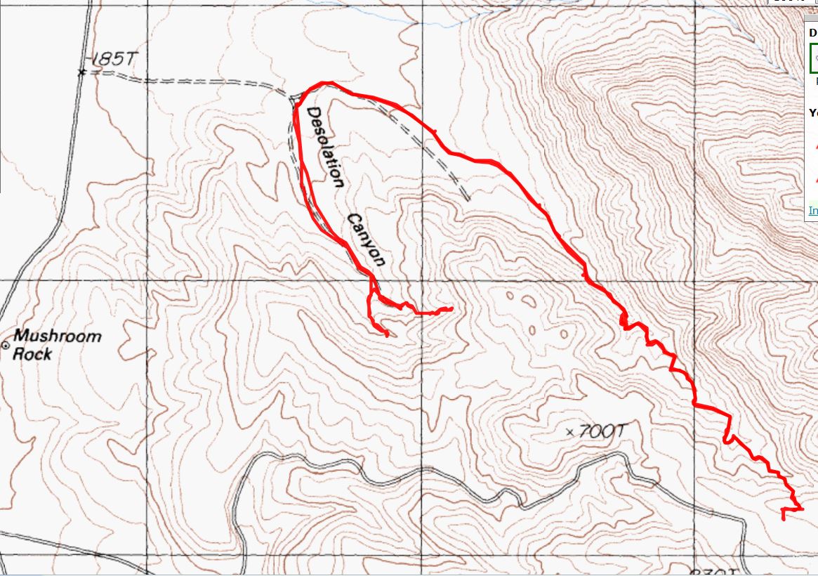
Day 8: Delightful Desolation. 5.5 miles, ERM = 9.5.
Map of the hike in Desolation Canyon (click) -pdf file, large file
Here's another, smaller file, map of the Desolation hike - jpg file
It's a calico pattern of desert minerals, not surprisingly akin to those of the
Artist's Palette, which is not far distant. Greg L., Rob P., and I are cruising up Desolation Canyon, the main (North) fork,
after exploratory ventures up two of the South fork options. Over easily climbed dry falls and through twisting narrows
we gain elevation to an overlook of the Artist's Loop Road. An excellent place for lunch, gazing South along the faulted face
of the palette, enjoying the gorgeous view, the super weather, and the good camaraderie. A footnote to a superb adventure.
Back in camp, under the Australian Pines, we partake of an early happy hour, then
do some preliminary packing of the vehicles in preparation for a sort-of early launch tomorrow.
The three-day weekend has brought out the trump behavior, especially in the RV
crowd, where everything is about them (me, Me, ME!). So, they make noise with abandon, destroy the dark sky with external
lights, and generally exhibit the callous narcissist behavioral characteristics of the head turd fondler and repulsicans everywhere.
It's a sad note, which inclines to sully the excellence that has been Death Valley Dreaming 2020.
A virus is exposing the hollowness
of a
generation of relying on businessmen to manage our government
Closing thoughts about the repulsicans and the Orange Clown Pufferfish by Heather Cox Richardson,
a political historian who uses facts and history to make observations about contemporary American politics.
She is the author, most recently, of "To Make Men Free: A History of the Republican Party."
February 27, 2020 (Thursday)
"It appears we are in the chaos that churns in between more stable eras.
The coronavirus is grabbing the headlines, and it is a huge story in its own right,
but it also lays bare the rot in the Republican Party that has put Trump in the White House. The coronavirus is a pandemic now,
meaning it is a disease that has appeared on a number of continents, and it is killing people, although the numbers of infections
and the death rate is so premature that I would not draw any conclusions yet. We know it’s not good, but just how not good it
might turn out to be is still unclear.
But the coronavirus and the subsequent selling-off in the stock market of the last
several days reveals what feels to me like an endpoint of a political era.
In 1980, Ronald Reagan won the White House by arguing that the activist government
of the New Deal, the laws that regulated business, provided a basic social safety net, and promoted infrastructure, were destroying
American liberty. “Government is not the solution to our problem;” Reagan said in his inaugural address, “government is the problem.”
After 1981, America entered a period when we turned for solutions not to educated
experts informing government policy, but rather to individuals who claimed to be outside that sphere of government expertise:
men of the people. As we celebrated those “self-made” individualists—usually men-- Congress cut taxes and regulation to free
them to run their businesses as they saw fit. After 1981, wealth began to move upward, and yet the Republican Party continued
to howl about socialism and insist that we would not have true freedom until all regulations, all taxes, and most government
programs were abolished. In their place we would have businessmen who had proven their worth by creating successful
businesses. They would run our country in the best way for all of us.
That this system worked well for everyone was a fiction, of course. Republican
leaders stayed in power not because a majority of voters agreed with their ideology, but because as their policies moved
wealth upward and hurt most Americans, they blamed those economic hardships on people of color, women, and other
minorities: “special interests” who were demanding government policies paid for by the taxes of hardworking white men.
They also increasingly jiggered the political system to make sure they stayed in power. They disenfranchised Democratic
voters and carved up districts so that in 2012, for example, Democrats won a majority of 1.4 million votes for candidates
to the House of Representatives, and yet Republicans came away with a 33-seat majority.
The election of Donald Trump to the White House in 2016 was the high water
mark of this political mindset. He was an outsider who posed as a successful businessman, disdainful of politics, who
promised to gut government bureaucrats—the swamp-- and put into office only the best people, people known for their
business acumen or their family connections to others with that skill. Expertise and loyalty to the American government
was unimportant—even undesirable. What mattered was the ability to make money and be loyal to the president.
Following in his predecessors’ footsteps, Trump slashed regulations, opened
up resources to businessmen, and passed a huge tax cut for the wealthy, a tax cut which was supposed to stimulate
investment in the economy and promote economic growth. In the midst of growing administration scandals, Trump
banked on the fact that a strong economy would keep him in office for a second term and insisted that those opposing
his administration, regardless of party, were hostile Democrats who wanted big government “socialism.”
Now, a virus from China is exposing the hollowness of a generation of relying
on businessmen to manage our government. The administration’s response to the coronavirus has been shockingly bad.
In 2018, it got rid of the government leadership for handling a pandemic, so we have no one in charge who is trained to
handle such a crisis. Then, when the virus broke out, the Center for Disease Control and Prevention insisted on developing
its own test, rather than using the guidelines established by the World Health Organization. Their test didn’t work, making
health officials unable to test people in danger before they got sick. Then, over the advice of the CDC, administration officials
decided to evacuate 14 infected patients who had been stranded on a cruise ship in Japan along with healthy travelers. We
learned today from a whistleblower that, once landed in the U.S., workers came and went from the facility that housed the
patients with no precautions. Now, we have our first case of the coronavirus that appears to have appeared here on its own,
and it happened in the same place where these workers came and went (although it is too early to say if there is definitely
a connection).
Trump has excused his dismissal of all the experts by saying that they were easy to
rehire when necessary, but it has not turned out to be that easy. Today, he appointed a third person to be in charge of the
response in addition to the two others he has already named, and, angry at the CDC official who warned Americans that the
virus would arrive here sooner or later, he arranged for all statements about the disease to be cleared through Vice President
Mike Pence’s office. He also revealed his key interest in protecting the stock markets today when he named two new members
to the coronavirus task force: Treasury Secretary Steven Mnuchin and Director of the National Economic Council Larry Kudlow,
who has insisted on television that the virus is “contained.”
In a moment that perfectly encapsulated the problem of handling a public health
crisis of this magnitude when you are equipped only to promote business, today Secretary of Health and Human Services
Alexander Azar, a former drug company executive and pharmaceutical lobbyist, told Congress that when scientists manage
to make a vaccine for the coronavirus (12 to 18 months out, by all accounts), not everyone will be able to afford it. “We
would want to ensure that we work to make it affordable, but we can’t control that price, because we need the private
sector to invest. Price controls won’t get us there.”
This is the modern Republican Party laid bare. Profits before lives, because only
businessmen, not government policy, can manage the country.
This moment makes it really clear what happens when the Republicans’ ideology
comes up against reality. While GOP leaders over the years, and Trump of late, have managed to silence opponents by
calling them socialists or making sure they cannot vote, the virus is not going to stop simply by changing the narrative or
the body politic. Investors know this, and the dropping stock market shows their realization that you cannot shut down
entire countries and keep supply chains and consumer goods moving. The stock market has fallen 11.13% in the past four
days, erasing a third of the gains it has made since Trump was elected. We are facing an economic downturn, one that
will strain an economy that was excellent indeed for those at the very top, but not good for those who now will be vital
to keep consumption levels up… but those very people will be hard pressed to come up with extra income in an economic
downturn. It is a problem that the markets are acknowledging with their biggest drops since the 2008 crisis.
This is a crisis that demands expertise and coordinated government health
programs, but we no longer have those things. Instead, Trump and his surrogates on the Fox News Channel are falling
back on the old arguments that have worked so well for GOP leaders in the past: Democrats are hyping the coronavirus
and spooking the markets to hurt the president.
Trump, and Americans in general, are about to discover that there comes a point
when image can no longer override reality. We are in the churn of that chaos now. But on the other side of it, we have the
potential to rebuild a government that operates in reality, and that works for all of us."
.
| ||||

.
Bird and Hike site content page: Death Valley hiking
Death Valley Dreaming: Biking and Hiking Death Valley - 2011
Death Valley Dreaming: Biking and Hiking Death Valley - 2012
Backpacking and Biking Death Valley - 2013
Backpacking and Biking Death Valley - 2014
Death Valley Dreaming and Marbelous Marble Canyon Backpack, 2015
Death Valley Dreaming, 2016 Winter Escape to DV Super Bloom, 2016
Death Valley Dreaming, 2017 Backpacking the Cottonwood-Marble Loop, 2017
Death Valley Dreaming, 2018 Hiking Telescope Peak (11,049') and Wildrose Peak (9,064'), 2018
Death Valley Dreaming, 2019 Escape into Winter, 2019
Scenic Toilets of Inner Earth.
Click here or on the happy cyclists to go to all WV reports about Bicycle Touring
| ||||
More Truth Than Joke:
Everyone is entitled to his own opinion, but not his own facts. Daniel Patrick Moynihan
| ||||

| ||||
| ||||

| ||||

| ||||

| ||||

| ||||
| ||||
| ||||
|
Wild Vagabond Main |
Trip Report Index  |
Caveat  |
|---|