Backpacking the Cottonwood-Marble Loop (47 miles)
Bicycling Badwater, Dante View, Stovepipe Wells (118 miles).
Day Hiking Echo, Palmer, Corkscrew, and Golden-Gower Canyons (32.6 miles)

|
| |||||


|
| |||||


|
| |||||


The bicycling adventures and Furnace Creek CG events were organized by Cheryl
Soshnik and others of the Wasatch Mountain Club. After the bicyling adventures, the WMC returned to Smog Lake,
and a few of us stayed to day hike DV. Finally, I backpacked the Cottonwood-Marble Loop solo.
Death Valley Dreaming, 2016
Winter Escape to DV Super Bloom, 2016
.
Camera: Panasonic DMC-ZS19
Maps: Please see the previous Death Valley Dreaming reports - maps for most of the hikes and
rides can be found there.
Day 1.
Driver - to Furnace Creek Campground. Walk frontage trail. 3 miles. ERM = 3.
I try to get the 35 year old Trek into the Subie and end up removing
both wheels, gift wrapping it in an old sheet (filthy chain) and flopping it upright behind the front seat.
Sometimes I miss the old Ranger, yet driving to DV, Death Valley, is such a breeze in the Subie Subaru,
and at 33 MPG too.
In camp, I talk with Rob Paull, then put together the Trek, inflate the
tires, and set up the tent, then enjoy a short walk prior to an amazingly early sunset, after which dark
collapses and bats ply the crepuscular.
It's cloudy and cool enough for a light pile shirt and long pants.
Photos: Day 2 of Death Valley Dreaming


Day 2. Holey Echo. Echo Canyon and Eye of the Needle. (day hike) Bill Sloan, NPS bighorn researcher
based in Moab. 9.6 miles, ERM =17.
This morning finds me crunching over the colluvial plain on a steady climb
to a hole in the wall and the narrows beyond, Echo Canyon. A single sun petro glows near the first canyon
constriction, artfully pecked on the polished limestone. Crunch, crunch, into Echo Canyon and to the Eye of
the Needle arch, and then another half a mile to where the canyon opens some. I try for photos back down
canyon and across to Telescope and Wild Rose Peaks, currently shrouded in snow.
I meet Bill Sloan, an NPS biologist studying Bighorn Sheep in the area and
we enjoy a wide ranging discussion. From Edward Abbey to the Grand Canyon to Moab to Canyonlands to Seldom
Seen Smith, and beyond. What an amazing trove of information these long-time NPS people hold.
The wind turns to cold and increases. It's cool enough for an ear band as
I crunch back toward the car.
Later, back in camp, Rick K. and Mark S., then Matt, John M. and Cheryl S.
and others arrive. They're here for biking with the WMC, Wasatch Mountain Club. And, so am I.
Of course, the talk turns to trumpmania, and how he is increasing jobs;
lots of new temporary jobs building bomb shelters; morticians too are in demand because of all those who
will die once the repulsicans repeal Obamacare. Religious is incompatible with conservative.
The conservative plan for having all Americans covered by health insurance (different from health care,
which is the goal of the people) leaves out the description "covered by 6 feet of dirt." Yes, everyone
will be covered by 6 feet of dirt. Yikes.
Photos: Day 3 of Death Valley Dreaming
 |
 |
 |
 |
 |
 |
Day 3. Badwater Breeze. (bicycle). 41 miles, biking to the low spot in the continental US.
Turning around South of the low spot, Badwater, at -238' below sea level,
the breeze from the North smacks me in the face. Wrong direction. The prevailing wind direction is supposed
to be from the South. Not today.
It's been a superb ride to here. Snow glistens on the crown of Telescope
Peak and its high neighbors. Far below, we bikers labor, weaving along the thin tarmac ribbon. Against
the wind, now it's an enervating struggle back to camp. I pause for a late lunch at the mouth of the Artist
Drive road, which helps revive me. Revival! The only revival! that should enter into our public lives;
let's have a "giant, beautiful, Yuge wall, a wall between church and State!"
Photos: Day 4 of Death Valley Dreaming


Day 4. Daunting Dante. (bicycle). Part way to Dante View from Furnace Creek
Campground. 31 miles biking, up 2500'.
The corrugated mountains hemming in the DV basin are dappled with
sunlight filtering through the dark clouds. Matt Davidson and I have climbed up past the 2000 feet
elevation marker, ridden toward Dante View a ways, enjoyed lunch amidst cooling temps, put on the few
extra clothes we have, then began the weightless drift back to camp below sea level. We're fueled by
another day-starting round of breakfast burritos cooked by Matt and John Marks. Yummy.
Now back below sea level, Matt and I turn into the high roller realm
of Furnace Creek Inn for a cactus cooler, where Matt and I are ogled by a grade A babe and her mother.
Cactus cooler.
Swaying back to camp, the sun shower water is heated and enjoyed before
happy hour with the WMC, Wasatch Mountain Club.
A magenta sunset dotted with roving bats ensues, addressing a calm night
punctuated by Horned Owl hootage and the obnoxious drone of winnehogo generators.
Photos: Day 5 of Death Valley Dreaming
 |
 |
 |
Day 5. Amber-ific. to Mesquite Sand Dunes. 46 miles, biking. Amber Giove, NPS, interpretive Ranger.
It's a cruise of a day. Easily we roll along the slight rollers to
the Mesquite Sand Dunes, where Matt and I enjoy a well irrigated lunch leaning against polished rocks
overlooking the dunes. We've received bottles of water from a group of Koreans and an British babe who
now lives in the U.S.
Opting to not go to Stovepipe Wells because of trepidation about the
possibility of wind, we start back to Furnace Creek after lunch. I know, it's only a mile or two more
to Stovepipe, yet Matt and I are happy with our stopping point at the dunes. More cruising. A government
vehicle pulls over ahead of us and Amber (Interpretive Ranger with the NPS) steps out to deliver snacks
from her own store of snacks. Amber-ific! Now, that's putting the "Service" in National Park Service!
After another heated sun shower in the Australian Pine shrubbery, I
cook up another breakfast burrito recipe prior to the NPS program about animals of the night at the DV
Visitor Center. Some claim the shaggy invasive trees under which we are camped are Tamarisk, yet they
are a similar-looking squatter called and Australian Pine.
A botanical site notes that "The Australian pine, also known as
“ironwood”, “horsetail tree”, “she oak”, “beefwood”, “Australian oak”, or “whistling pine”, has a pine-like
appearance but is not a pine (Pinus), an evergreen, or a conifer. Rather, it is a deciduous tree whose
branchlets of scale-like leaves are mistaken for needles, and whose round brown fruits resemble acorns."
Another source reports that "Australian pine now occurs throughout South and Central Florida, the West
Indies, Mexico, and elsewhere in tropical regions outside its native range. Because of its aggressive
growth rate, never plant Australian pine trees. There are native trees that provide shade and do not
harm the environment. Possession of Australian pine with the intent to sell or plant is illegal in Florida
without a special permit." Are we talking about invasive plants or republicans and the one-percenters
(of both parties)? Is there really a difference? Both are selfish and take all the resources available,
refusing to share with others, including those who have helped in their establishment.
Clouds scream across the nearly full moon. Lenticular, cirrus, dark
plates of clouds. What weather mischief do they portend?
.
Photos: Day 6 of Death Valley Dreaming
 |
 |
 |
 |
 |
 |
 |
 |
 |
 |
 |
 |
Day 6. Palmer. (Hiking). Hiking to Palmer Canyon. 6 miles, ERM = 12.
with Donn Seeley and Jerry Hatch and Mark Shipman.
The squiggly lines of the geologic layer cake dominate the
up canyon view through the Palmer Canyon narrows. It's an overland route to this canyon, one
that rolls through Fall Canyon and an unnamed neighbor before the gravel crunch up Palmer,
gaining altitude to about 2000' before the lower narrows open. A band of Bighorn Sheep slips
across Palmer as we return to the car park. Silent and tawny (matching the background color),
we would have missed them if not for Mark's sharp eyes. The car park is at the mouth of Titus Canyon.
It's a pleasantly cloudy day, which helps with the heat control.
Earlier today, most members of the WMC quickly pack up and depart
on the long road back to the land of smog and inversion and selfish retrograde politicians. Some of
us remain for more fun.
It's much cooler today. Last night was nearly hot.
Dusk descends, quickly, as Mark and I scramble to cook dinner before it's dark. What happened to the late afternoon?
Burritos, beer, Mango-rita, chips and salsa and veggies and humus. Yummy.
Photos: Day 7 of Death Valley Dreaming
 |
 |
 |
 |
 |
 |
 |
 |
 |
Day 7. Screwed to Corkscrew. (Hiking). Hike to Corkscrew Canyon. 7 miles, ERM = 10.
Drizzle drips fly into the slot from the gray sky. Propelled by the
restless wind, it almost reaches into the overhang where Mark and I are eating lunch. It's a tight fit
in Corkscrew. We've found a natural bridge and slots nearly to the base of abrupt cliffs. With the
yearly total rainfall in DV approximately 2", it seems that we are getting a good deal of it today.
Starting off from the 20 Mule Team road, we hike a low slot to join
the Corkscrew main wash, then follow it up towards bands of colorful rock, the backside of the Artist Palette?
It's been raining feebly, yet enough to require a raincoat since we
left Furnace Creek, and this will continue until after we shower at the Ranch, then dribble again
after dinner and sunset. It's much cooler today.
As we meet the main wash, a rainbow develops over the Hole in the Wall
area. Gorgeous.
After dropping out of the narrows of Corkscrew, we briefly explore
the other upper canyon arm to see the Corkscrew Mine, where we find a scenic toilet. Gravel has
washed down the slope to fill the toilet to the top of the seat. Awkward ergonomics.
Photos: Day 8 of Death Valley Dreaming
 |
 |
 |
Day 8. Hiking is Golden. (Hiking). Golden-Gower Loop from Zabriskie Point. 7 miles, ERM = 10.
I turn the ignition key on the trusty Subie and all that I hear is
"click, click, clickety, click." Yikes! It's fortunate that Mark S. has not yet departed for Smog
Lake because he jump starts the Subie. I'd somehow left the fan going when charging phone and camera
batteries. Argh.
I'm off to check with the NPS about the Cottonwood-Marble backpack
loop. Then, over to the TH for a moderate hike of the Golden-Gower Loop.
Stripes askew on faulted benches, mountains, points. Colors abound
and the wind is brisk on this 75F day. I'm late to the TH and it's clogged with winnehogos and
vehicles of all sizes. So, I drive around to the Zabriskie Point side and start the loop here.
Everything looks different going the opposite direction.
Views pop to Telescope Peak, although it's a bit obscured by wind
riled dust. Yellow cake-like mudstones, red canyon, variegated faulted blocks, gorgeous.
On the return to camp I get some pricey ice - the original blocks
in the cooler are nearly gone. A sun shower, some eggs with onion, sausage bits, cheese, and avocado
and daylight expires. I sort equipment for the planned backpack. With a slight delay to the rising
of the just past full moon, there's time to introspect about the billions and billions of stars.
.
Photos: Day 9 of Death Valley Dreaming
 |
 |
 |
 |
 |
 |
Day 9. Day 1 of backpacking the Cottonwood-Marble loop. Cottonwood Caper. (Hiking). To
Sidewinder Spring at the end of the Cottonwood jeep road. 10.3 miles. ERM = 14. Total backpack trip
miles = 47. Total ERM = 74.
A lone lonely Cottonwood appears as if a mirage. Is it really
there? Crunch, crunch, it's been a long day on the gravely colluvium ramp from near 900 feet where I
parked to Sidewinder Spring, where it's about 2800 feet above sea level; something new because I've
been dwelling below sea level for the past week. The end of the road arrives, and soon more Cottonwoods
and precious water. A good camp soon appears; then I seek water. I walk up canyon and find dust and wet
soil. I head back toward camp. Eventually, I see a few broken brush bits and find a pool of decent water.
Jason, Hardy, Catlin hike in, breaking the history of seeing no one
on this loop.
The geography and geology is sometimes quite interesting on today's
jaunt, with some wide narrows and a peek at a slot - the same slot that lures the unwary when the route
goes up the ridge to Dead Horse (rather than continuing down what becomes this slot).
Along the way, I stop for lunch in the cleft of a cave which provides
scrumptious cool shade from the intense sun (although the forecast is for temps below 80F). The hefty
pack drags on me some because I brought extra water (total of 5 liters) due to assorted contradictory
information about the springs. So, as you can imagine, I am seriously happy to see the lone lonely
Cottonwood.
Photos: Day 10 of Death Valley Dreaming
 |
 |
 |
 |
 |
 |
Day 10. Dividing Dead Horse. To Dead Horse-Marble junction. (Hiking). 12.1 miles, ERM = 21.
The Cottonwood Spring water fairly rips through the verdant Miner's
Lettuce and other aquatic plants. An excellent flow. There is also a good flow near the possible camp
down canyon. Unshod ponies and burros have left trump apples and footprints throughout this section of
the canyon. It's past time for birth control for these and the repulsican invasives.
Arriving at the Cottonwood Spring area by 11:30 a.m., I take a foot break,
filter and guzzle a liter of cool spring water, and consider the jump to Dead Horse, which is what I do.
This means plugging away without long breaks to make it to the next water
in time to set up in the light.
Leaving the Cottonwood Spring area, I encounter a Bighorn Sheep skull with
an impressive curve of the horns and I wonder what happened to this big guy.
Trudge, trudge, up the long drainage on a colluvial plane past surreal
street signs announcing Keller, Gold Belt, Cottonwood, Jackass. This was once a popular route between
mining devastations. Today, it's a part of the huge Death Valley National Park. This public land
belongs to all people of this nation, not just the corporate welfare folks (who expect to use and abuse
the land and have the rest of us pay for cleaning up their mess and pay for the health effects of poisoned
water, foul air, erosion, lack of access, etc.); something few Western politicians seem to grasp. Of
course, American citizens "get it," both the concept and the bill.
The route veers NE toward a low spot in the ridge (now over 4500'), from
which it drops precipitously to then rise to the ridge above Dead Horse Canyon. The wind is keeping me
more than cool, and I'm happy to drop out of it toward Dead Horse.
Hot dog fighter pilots destroy the natural quiet, as they have all week,
pumping hydrocarbons into our atmosphere and "winning, winning, winning" (trump slogan rather than policy)
if you are a defense contractor and don't care about global climate catastrophe.
The Dead Horse Spring is running well, including a trickle over the
normally dry 8' fall, making the downclimb a bit interesting.
The daylight is fading as I set up camp near the Dead Horse-Marble
junction and the temperature is dropping too. Bats come out for dinner as I'm eating mine.
While writing these journal notes, stars blossom in this desert sky,
heightened by the lack of intrusive light. The Milky Way is a speckled glow stick across the narrow
slice of canyon sky. The best ambient mood light ever; and so rare on an Eaarth of nearly 8 billion people
(and exploding beyond 8 billion).
Photos: Day 11 of Death Valley Dreaming
 |
 |
 |
Day 11. Dead End Dead Horse. (Hiking). Explore Dead Horse Canyon. 7.9 miles, ERM = 14.
The hootage of the Longear Owl nudges me out of sweet dreams of alabaster
skin and luscious upholstery. Day 3 of the backpack begins. Because I hiked farther than planned yesterday,
I now have two day hike days. Given the proximity of water, this is a lovely base camp.
So, I set off to explore Dead Horse Canyon, looking for a possible route
over to the head of Cottonwood Canyon. At first it's a gentle walk up Dead Horse. Then, brush occasionally
crowds the canyon, then there's a minor dry fall (easy to climb), then another slide (now wet) which can be
bypassed, then, almost to the seep indicated on the topo, there is serious canyon brush clogging and I call
it good enough for today. Quail and Chukar Partridge stream from the thick Rabbitbrush. There's a seep
nearby. It's not a particularly interesting route to repeat, so I believe that I have enough information.
Besides, I want to return to camp in time for a decent bucket bath and a lounging dinner too.
I return to dismay at a small hole a Raven (apparently) has poked in
the top of the TarpTent. Argh, time to fire up the BBQ. I'd taken the food bag on today's jaunt, yet
left the tent.
Bats and an Owl prowl the crepuscular as high clouds slip over the
sky, obscuring the neon night sky.
Photos: Day 12 of Death Valley Dreaming
 |
 |
 |
 |
 |
 |
 |
 |
 |
Day 12. Day 4 of the backpack. Ravine Ridge. A Jekyll and Hyde day. (Hiking).
7.7 miles, ERM = 12.
The big-headed Owl silently rows the canyon narrows quieting the
chucking chuckling Chukar and the quibbling Quail. One of the Eared owls. Marbled nicely, hiking
this canyon is a glorious start to another DV day, which doesn't last long enough.
Again, the fly boy 100 decibel billion dollar air sleds destroy
the natural quiet. Argh. Today seems to be a particularly noisy one. Perhaps the coming storm is
forcing more fly time today? It's an on and off day, sun, clouds, wind, dribble near sunset. Not
a good day to charge the solar battery system. Jekyll and Hyde weather.
Before the icky weather begins, I'm off hiking Marble Canyon to
the spring (about 2 miles up Marble; flowing well), then over the ridge past some Joshua Trees and
down to Dead Horse Canyon, to loop back to camp. I pause at the foot of the Dead Horse divide route
for a snack and I'm joined by a group of White Crowned Sparrows, also snacking on something under the brush.
It's too late to pack up and depart and too early to hang in camp,
so I drift down canyon through the first narrows. Delightful. I enjoy a brief bucket bath just prior
to another cold pulse.
It's calm at sunset and the owls return to their homey hootage. I
ask them if the rain will hold off so I can enjoy the Marble Canyon narrows tomorrow. Their
answer is "Who?"
Day 13. Day 5 of the backpack. Soggy Slot Slog. Complete the loop, to car, then home.
9 miles, ERM = 13. Total miles = 47. Total ERM = 74.
The wind-driven rain begins in the early morning, pelting the
TarpTent and whipping rain under the fly. I'm happy that rain is not (yet?) leaking through the peak
ventilation hole pecked by a Raven. I snuggle into the Marmot bag and attempt to go back to sleep
until it's light enough to see.
It's still raining at the time of sunrise, although it's dark enough
that sunrise is doubtful.
I pack to the extent possible in the TarpTent, don the rain gear, add
the remaining lunch snacks to my pocket, and get out to wrestle with the TarpTent in the rain and wind.
This works poorly, and I roll lots of wet sand up with the tent. Adding a pack cover, I launch toward
the first of three narrows in this section of Marble Canyon, concerned that the ground is becoming
saturated, and water might start flowing (and in my worst scenario, boiling) through the sections
where one can nearly touch both canyon walls at the same time. Yikes. It's a fast, yet wet, tour
through the 6 miles to the road end, where the canyon broadens for good. Chilly rain water is by now
leaking through the previously warm crotch area and down my legs. Argh. I duck into the rain shadow
created by an overhanging and gorgeous canyon wall to make clothing adjustments. I note that the water
is rising through the underfoot gravels and that streamlets are beginning to flow through the narrows.
Yikes. Keep moving.
Onward. I'd like to take photos of the petros (although the wet rock
art is not easily seen) and the low riding dark clouds scraping the hills upstream, yet I've packed
the camera to keep it dry and me going.
At the road end, the hike to the Subie, and the drive all the way
back to the tarmac at Stovepipe Wells, I see no one, no one at all.
Rain continues, and so do I, first to the DV Visitor Center to report
on the springs, and report an excellent Death Valley Dreaming adventure. I hear on the radio that this
storm front is part of a system predicted to drop 10 inches of moisture in California. Is a molding
mudder of mudslides and debris flows in store for the area?
The fierce wind accompanying the area-wide weather front reduces my
Subie's average MPG on the return to the Colorado Plateau, and I'm happy that the ancient Trek bicycle
is inside the vehicle rather than hanging out in the wet and wind closing out another edition of Death
Valley Dreaming.
Photos: Scenic Toilets of Death Valley Dreaming 2017
 |
 |
 |
 |
 |
 |
.
Seeley's Travels, Death Valley 2016
Bird and Hike site content page: Death Valley hiking
Death Valley Dreaming: Biking and Hiking Death Valley - 2011
Death Valley Dreaming: Biking and Hiking Death Valley - 2012
Backpacking and Biking Death Valley - 2013
Backpacking and Biking Death Valley - 2014
Death Valley Dreaming and Marbelous Marble Canyon Backpack, 2015
Death Valley Dreaming, 2016 Winter Escape to DV Super Bloom, 2016
Scenic Toilets of Inner Earth.
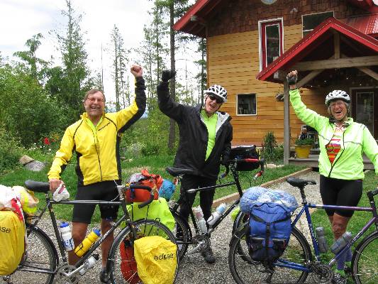
Click here or on the happy cyclists to go to all WV reports about Bicycle Touring
| ||||
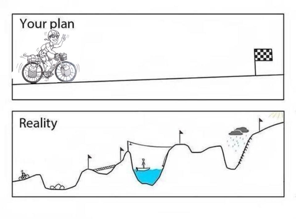
More Truth Than Joke:
| ||||

| ||||

| ||||

| ||||

| ||||

| ||||

| ||||
|
Wild Vagabond Main |
Trip Report Index  |
Caveat  |
|---|