Cedar Mesa, Utah

|
| |||||
|
| |||||
|
| |||||

| ||||
| ||||
| ||||
Summary: Jeremy and I enjoyed a
slip and slide backpack in Slickhorn Gulch and two terrific day hikes, one to Moon House Ruin
and one on the Bridges Loop in Natural Bridges National Monument. Here are the tales about these adventures.
Co-adventurer: Jeremy Wright
camera: Panasonic DMC-ZS19
"Reality has a well-known liberal bias." - Stephen Colbert
You will not see waypoints for any of the archeological features (e.g.,
ruins, pictos, petros) in the report maps. You will see references to camps and arches.
Moonhouse Photos - Day 1


Day 1. Moonhouse Musings : 4 miles. ERM = 5.
First, there is Moonhouse. Gazing at what appear to be phases of the moon
carefully painted around the wainscot of one of the interior rooms - Jeremy thinks that perhaps it should
be called phases of the sun house. Interior rooms are lighted by the glow of sunlight filtering through
the portals in the outer wall. A snake pictograph crawls across the sandstone above this shielding wall.
Fingerprints made by ancient craftsmen are easily seen, clear enough that I wonder if a fingerprint analysis
could take place.
We're up early and on the road in the dark, roving the Colorado Plateau into
Utah. Checking in at Kane Gulch Ranger Station, we hear tales of a recent flash flood that has rearranged
the canyons. However, the roads to Moonhouse and to Slickhorn Gulch are passable. So, with day and backpack
permits in hand, we're off to the slow road to Moonhouse.
We share the area with only two others, who leave and race to the next bucket
list item while we enjoy lunch in the alcove of the ancients and laterally prowl the ledge, finding more
structures, including a fallen kiva and what we envision is a lodge for visitors or in-laws.
After bumping out from Moonhouse, and jolting to the accesses of Slickhorn
Gulch, we are finally satisfied that we have determined which Slickhorn access is which, and camp at the
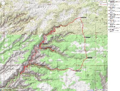
top of Access #4. If you go, note the GPS coordinates of Slickhorn Accesses 1-6 on the map (UTM; NAD27 datum)
because the driving distances are incomplete in the BLM literature. As the day settles, it's cool and quiet.
Jeremy comments enthusiastically about the brightness of the Milky Way and the billions and billions of
complementary stars. It's a dark sky night - because there is a new moon, and almost no light intrusion. Rapture.
Slickhorn - Day 2
 |
 |
 |
 |
 |
 |
 |
 |
 |
 |
 |
 |
 |
 |
 |
Day 2, Day 1 of backpack. Slickhorn! Perfect Kiva! : 8.95 miles, ERM = 13.
Scrambling up the Cedar Mesa SS (sandstone) boulders and ledges we
see a solitary granary and a fallen wall. Then, Yowee! Better scrutiny reveals a ladder protruding from
the floor of the alcove. Peering in - Perfect Kiva #2 (#1 is in Bullet Canyon)! Descending into the
gloom of the Perfect Kiva, we see that recesses are expertly fashioned into the wall. The ceiling is of
juniper poles laced with willows and chinked with bats of juniper bark, stained black by years of ceremonial
files. Impressive construction. Durable. The roof, built ages ago, perhaps long before the committee
fiction of the bible, still holds strong and elegant.
To start the day, we drop off packs at Access #1, return the truck to the
TH (trailhead) for Access #4, and road-walk back to Access #1 to start the hike. We slip slowly into Slickhorn,
the rim gradually rising above us as we slickrock walk down the drainage, swept clean by recent rains. After
about 1.5 miles the reverberation of sound in our canyon changes just perceptibly. We are forced to hike around
a dramatic pour-off, pouring into a drop of 200 feet or so of desert air. Where's the route? Soon, we are
climbing up, skirting around, scrambling down to the now several hundred feet lower canyon floor. Wrestling
with terrain, mud, and tamarisk-willow thickets to below the Kiva, it is a struggle, after which some delightful
bench walking is enjoyed to the junction with Access 2-3, which have combined just upstream of Slickhorn proper.
The bench walking continues to Access 4, and we hike upstream in #4 until we see precious water coursing over
slickrock, pockets of cattails gracing the flow. Lovely! Jeremy and I are tired, yet explore upstream for a
camping spot, encountering nearly impassable oaks, jungle-type grass which saws the legs, willows, and such.
No luck. We consider going back to the junction of 4 and Slickhorn, yet camp on the slickrock near the spring instead.
A brilliant band of Milky Way cuts across our narrow sky strip. Stars pop,
glittering brighter than elsewhere. Bats loop and quiet is absolute but for a faint trickle from the precious
spring. A dark sky night is enjoyed while we cook on the slickrock.
Slickhorn - Day 3
 |
 |
 |
 |
 |
 |
 |
 |
 |
 |
 |
 |
 |
 |
 |
Day 3. Artistic Exploration: 4.4 miles, ERM = 7. up total 1786, down total 1758.
The duck head (headdress?) or quail picto glows mystically from the
sandstone canvas. Jeremy and I are contemplating a rock art panel up canyon from Access 4. We've also
found a ruin upstream in #4, and a gorgeous plastered round granary across from Access 2-3. A Hotel
California Kiva is ensconced below a long shelf where mortared support posts once stood - now burned to the nub.
We discover a good camp in the juniper near the junction of #4 and Slickhorn,
and relish moving camp, yet don't because our slickrock camp near the spring will soon be in the shade.
We appreciate the springs near our lesser camp, yet envy the shady and flat environs of the juniper camp.
It's hot today, and we're happy to be able to sneak into the shade when
we overheat.
A bucket bath and some laundry, followed by dinner and some rum writing
and star gazing pave the way into sleep. Orion brightly beckons during the close of the evening.
Slickhorn - Day 4
 |
 |
 |
 |
 |
 |
 |
 |
 |
Day 4. Bufus-ville : To Access #6 junction, explore to next Canyon. Camp @ 5200'.
Total miles = 18.4, today = 5.1, 3 miles backpack, up 2303 total, down
2652 total. ERM = 8.
Walking the early angle canyon light past a slippery slide to a pool
left over from the recent big rain, I note the distinctive track of Twinkle Toe from Wisconsin - and,
wait, something else. What? Bufus Bear! Ursus Americanus. Clear imprints of front and back feet. Trucking
up canyon, and about the same time Twinkle Toe apparently returned to the vehicle at Access #1, Bufus passed
perhaps last night or very early today. We did not see either walker.
We follow Bufus down canyon to good water at Access #6, and from there
down to the next canyon entering from the East. The section to Access #6 is decent hiking, while the
rest is a bit less fun, being clogged with brush, other plants, ripped up stream channels, and such.
Short stretches of bench walking end at vertical flood cuts, sometimes taller than we are. It makes me
reconsider the long trek to the lower spring.
It's hot on our return to Access #6, and cool hats, wet from the pools,
are required.
There's no spring or great camp at the next canyon down, so we opt to
stay where Trail Canyon (Access #6) meets Slickhorn Gulch.
Jeremy is filtering the lovely spring water while I make journal notes,
a light and welcome cloud cover rolls over a cerulean sky, and afternoon slips into canyon time. This
water is much better than that we found in Access #4 canyon.
I'm happy to be in a good camp with nearby clear spring water than on the
mostly exposed slickrock, drinking and smelling the odiferous green brew in #4.
Clouds thicken and we wonder about the forecast. Will we be the Slickhorn
Gulch swim team or graced by cooler temps and overcast skies?
Note - the storm that subsequently jumps into the area results in several
people being killed by flash floods in the industrial propagation polygamous towns of Colorado City/Hillsdale
and in Keyhole Canyon in Zion - a total somewhere over 20 dead.
Slickhorn - Day 5
 |
 |
 |
 |
 |
 |
 |
 |
 |
Day 5. Ledging It To Ledge Ruin : Out #6 and return to #4. 5.4 miles, ERM = 8.5.
Total miles 23.7. Camp @ 6230'.
The air step looms large over the sheer drop from the ledge ruin to the
springs area below. Yikes! Or, is this the "one and done" step? Either way, it seems a little bit silly
to sneak around the corner to see the wattle and plaster structure at the West end of the ranging ledge
complex. "How about a telephoto shot from here?" I ask myself. "Nah, it's just a bit farther, you can do
it, it's a mild clingon move." I tell my more timid inner self. Jeremy and I are roving the ledge far
above the canyon floor, inspecting the assorted granaries and other structures of yore. We took the difficult
route up here, including some friction slickrock scrambling across patina-stained sandstone. Along the way,
we encounter an insurmountable pour-off, and later learn how the trail climbs the other side of the canyon,
bypassing the pour-off and also granting access to the ruins via an easier assent. It's easy to see the correct
path from our sky perch.
It's obviously a horse trail at this point - climbing to bypass the pour-off,
yet difficult to locate from below and thoroughly gone in most of the canyon.
After hearing the weather report (rain and wind) and experiencing the flood
debris down canyon, and weighing these with the distance to the lower spring - well, we opted to depart via #6
today. That's how come today's report is not about trying to find the lower spring in Slickhorn.
On and off track, trail, and route, we surmount the canyon rim and set a GPS
course for the old coral that represents the start of Access #6, reaching it shortly. Then, there is the road
walk back to Access #4 and the truck for beer, shower, dinner, hydration, and an early bedtime to escape the drizzle.
We've seen no one since leaving Moonhouse four plus days ago. Regrettably,
not even the Bufus Bear.
The wear and tear we feel belies the total mileage, yet is entirely
representative of slogging Slickhorn Gulch.
Big Bridges Boogie - Day 6
 |
 |
 |
 |
 |
 |
 |
 |
 |
 |
 |
 |
 |
 |
 |
 |
 |
 |
Day 6. Big Bridges Boogie : Natural Bridges national monument loop. 9 miles, ERM = 13. Camp @ 6500'.
The overlapping rows of intricately-painted triangles center the high
rock art panel, figures scattered above and below in an ancient tale of direction or mythology or artful art.
Jeremy and I are touring the last segment of the Bridges Loop in Natural Bridges National Monument, and my
feet are protesting the beating that they have received. Along the way, we have seen two huge natural
bridges, Sipapu and Kachina, Horse Collar Ruin, Indian Foot Arch, pictos and petros on the buttresses of
Kachina, various structures of yore - some in high alcoves and some near the NB buttresses, a gorgeous
French woman with sheer lace hiking short shorts, a Willy Wonka chocolate factory type pour-off flow, and
lots of slippery red silt mud and water from the 0.5 inches of rain last night. Natural bridges as skyrock,
what amazing spans. And, we have yet to experience Owatchomo NB. What a visual bonanza.
We leap across deep red water, jumping the gulf between Cedar Mesa Sandstone
slickrock and a grassy hummock, to avoid the last challenge to our dry boots. Success.
Before long, we're climbing out of the canyon and through! Owatchomo NB,
just about the time it's local sunset on the canyon rim.
Returning to camp, we heat water to complement the tepid solar shower water,
and relish in removing a layer of salt with luxurious hot water.
A brief rainstorm arrives as soon as dinner is ready and a warming fire is
well established. Bushco! ("bushco!" is the universal epithet, properly categorizing this worst
presidency/administration in U.S. history; murdering hundreds of thousands of innocent people, accelerating
and setting in motion 100 more years of religious wars, and casting millions into poverty while enhancing the
power and larder of corporations and the rich while vastly increasing our national debt.) The rain fades,
some stars appear, and Jeremy and I drift toward tents and dreams of the Big Bridges Boogie.
It's been a fabulous tour of mystical Moon House, Slogging and Sliding
Slickhorn, and Big Bridges Boogying.
| ||||
. .
.
Peter Francis Tassoni (2001) A Hiking Guide to Cedar Mesa: Southeast Utah, University of Utah Press.
Grand Gulch Grandioso: Kane RS to Pour-off near San Juan River and out Collins Canyon TH, 2011
Bucolic Butler Wash: Ruins or ruination? Butler Wash – Cedar Mesa area, Utah, 2009
Cedar Mesa Somewhere - Hiking the Trails of the Ancients, 2001
Click here to see Alum water treatment for backpackers
Scenic Toilets of Inner Earth: Scenic Scatology of the Wilderness Vagabond
Bill Mckibben - climate change and the flood this time. .
| ||||
| ||||
| ||||
| ||||
| ||||
| ||||
| ||||
Link to below Onion article (click here).
Scientists: 'Look, One-Third Of The Human Race Has To Die For Civilization To Be Sustainable, So How Do We Want
To Do This?'
Scientists say at least 2 billion dead bodies will be burned and converted into fossil
fuels.
26 Jan. 2012 | ISSUE 48•04
WASHINGTON—Saying there's no way around it at this point, a coalition of scientists
announced Thursday that one-third of the world population must die to prevent wide-scale depletion of the planet's
resources—and that humankind needs to figure out immediately how it wants to go about killing off more than 2 billion
members of its species.
Representing multiple fields of study, including ecology, agriculture, biology,
and economics, the researchers told reporters that facts are facts: Humanity has far exceeded its sustainable
population size, so either one in three humans can choose how they want to die themselves, or there can be some
sort of government-mandated liquidation program—but either way, people have to start dying.
And soon, the scientists confirmed.
"I'm just going to level with you—the earth's carrying capacity will no longer
be able to keep up with population growth, and civilization will end unless large swaths of human beings are killed,
so the question is: How do we want to do this?" Cambridge University ecologist Dr. Edwin Peters said. "Do we want to
give everyone a number and implement a death lottery system? Incinerate the nation's children? Kill off an entire
race of people? Give everyone a shotgun and let them sort it out themselves?"
"Completely up to you," he added, explaining he and his colleagues were "open to
whatever." "Unfortunately, we are well past the point of controlling overpopulation through education, birth control,
and the empowerment of women. In fact, we should probably kill 300 million women right off the bat."
Because the world's population may double by the end of the century, an outcome
that would lead to a considerable decrease in the availability of food, land, and water, researchers said that,
bottom line, it would be helpful if a lot of people chose to die willingly, the advantage being that these volunteers
could decide for themselves whether they wished to die slowly, quickly, painfully, or peacefully.
Additionally, the scientists noted that in order to stop the destruction of global
environmental systems in heavily populated regions, there's no avoiding the reality that half the world's progeny will
have to be sterilized.
"The longer we wait, the higher the number of people who will have to die, so we
might as well just get it over with," said Dr. Chelsea Klepper, head of agricultural studies at Purdue University,
and the leading proponent of a worldwide death day in which 2.3 billion people would kill themselves en masse at the
exact same time. "At this point, it's merely a question of coordination. If we can get the populations of New York
City, Los Angeles, Beijing, India, Europe, and Latin America to voluntarily off themselves at 6 p.m. EST on June 1,
we can kill the people that need to be killed and the planet can finally start renewing its resources."
Thus far, humanity has been presented with a great variety of death options,
among them, poisoning the world's water supply with cadmium, picking one person per household to be killed in the
privacy of his or her home, mass beheadings, and gathering 2.3 billion people all in one place and obliterating
them with a single hydrogen bomb.
Sources confirmed that if a death solution is not in place by Mar. 31, the U.N.,
in the interest of preserving the human race, will mobilize its peacekeeping forces and gun down as many people as
necessary.
"I don't care how it happens, but a ton of Africans have to go, because by 2025,
there's no way that continent will be able to feed itself," said Dr. Henry Craig of the Population Research Institute.
"And by my estimation, three babies have to die for every septuagenarian, because their longer life expectancy means
babies have the potential to release far more greenhouse gases going forward."
While the majority of the world's populace reportedly understands this is the only
option left to save civilization, not all members of the human race are eager to die.
"I personally would rather live, but taking the long view, I can see how ensuring
the survival of humanity is best," said Norwich, CT resident and father of three Jason Atkins. "I guess if we were to
do it over again, it would make sense to do a better job conserving the earth's finite resources."
"Hopefully, the people who remain on the planet will use the mass slaughter of their
friends and loved ones as an incentive to be more responsible going forward," he added.
|
Wild Vagabond Main |
Trip Report Index  |
Caveat  |
|---|


