Fantastic Fish and Owl Backpack Loop
and - Secret Ruin and Natural Bridges Loop Hikes: Cedar Mesa
May 28-30, 2013

Text and photos © copyright by Rob Jones

Co-adventurers: Kathleen and Rob
Panasonic DMC-FZ200 camera
Secret Ruin on Cedar Mesa
(Click the image for the full-size image)

Pano of Horse Collar Ruin
(Image is very wide - scroll to view it (4117 x 900; 1 mb) - Click the image for the full-size image)

Movie - Secret Ruin on Cedar Mesa
Movie - Movie - Secret Ruin on Cedar Mesa - 8.6 MB
(Click the image to see the short video)

     *ERM = Energy Required Miles. A mile is added for every 500' elevation gain or loss. ERM was initially used in Trails of the Tetons (long out of print) by Paul Petzold, founder of NOLS. It's a wonderfully useful concept and application. Add one mile for each 500' up AND down to distance = ERM. I use ERMs to calculate what the actual day is like. It's a very serviceable method of estimating energy required miles.

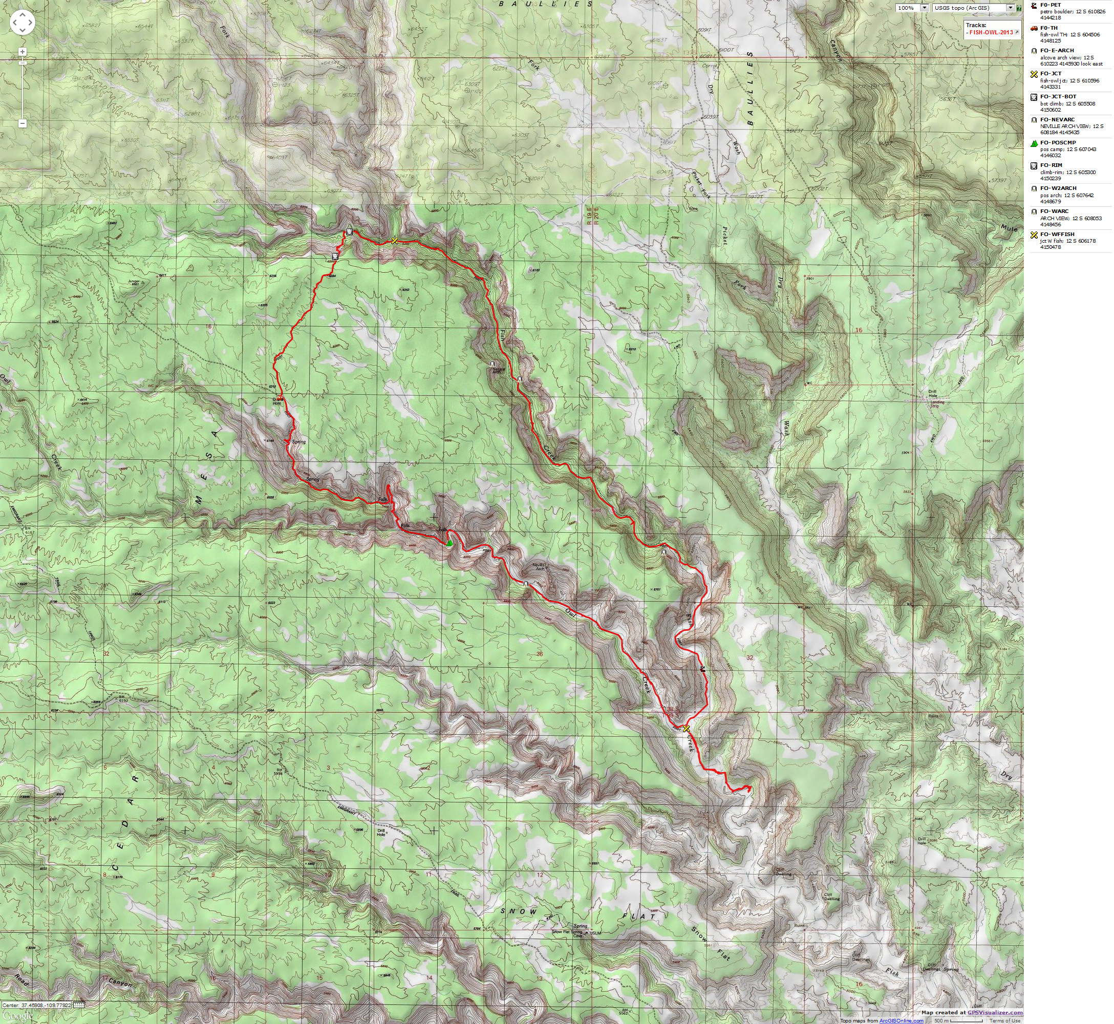
     Estimated mileage and ERM for this trip (loop only) - GPS trip total of 19.6 miles with an ERM of approximately 29.6.

Map - Fish & Owl loop 2013; 20 miles
(Click the image to see the map)

for a full-resolution map, click here. Caution - do not use this map or gps track for navigating the route.

Fish and Owl loop: Right Click (then save this file: "save link as..." in most browsers) on this Download link to get the GPX file from my GPS - you can then open it in your mapping software. Note - that's a Right Click on this link. You will get the track for your software shown in the map above.

     "Reality has a well-known liberal bias." - Stephen Colbert.

(Photos and the report of the trip continue below.)

     Day 1: No Ouzels in Owl: To below Fish-Owl junction. 8.5 miles; ERM = 12.5; camp @ 4800'.
     The blast of wind has faded and again it's dead calm. Clouds rove to the South and West and we get a few more sprinkles, which dry nearly as fast as they fall.
     We're a bit over a mile below the Fish-Owl junction, where we've hiked looking for water. We find decent water, complete with giant tadpoles, who speed off in the shallow pool whenever a shadow passes over them.
     We start the day at Natural Bridges NM CG, where we fortunately found the last site last night. A pleasant place. Then, this morning, we check in at the Kane Gulch RS and get our permit (advance reservation).
     Then, off to the trailhead, which is near 6200', for the final pack-up. Heading down into Owl, we see two ruins while slip-sliding on several slickrock descents. The upper part of Owl Canyon is more serpentine and more difficult to negotiate, including routes around three pour-offs, one of which requires a short hike up a side canyon to circumvent. It's just a bit of gription, no climbing required. There's water intermittently in the top of Owl, yet it goes underground before we see huge Nevills Arch on the skyline. From here, the canyon and route straightens and soon we're at just over 7 miles from the TH and nearing the confluence of Owl and Fish Canyons. There's no water near the junction, so down canyon we hike.

Day 1 photos - Fish & Owl, 2013

Click thumbnail to see full size image
wfish-owl-2013-day1-1  into Owl.jpg (472360 bytes)

wfish-owl-2013-day1-1 into Owl.jpg

wfish-owl-2013-day1-2  ruin in Owl.jpg (451049 bytes)

wfish-owl-2013-day1-2 ruin in Owl.jpg

wfish-owl-2013-day1-3  ruin in Owl.jpg (295245 bytes)

wfish-owl-2013-day1-3 ruin in Owl.jpg

wfish-owl-2013-day1-4  texture.jpg (390913 bytes)

wfish-owl-2013-day1-4 texture.jpg

wfish-owl-2013-day1-5  penstemon.jpg (245542 bytes)

wfish-owl-2013-day1-5 penstemon.jpg

wfish-owl-2013-day1-6  pour-off.jpg (271082 bytes)

wfish-owl-2013-day1-6 pour-off.jpg

wfish-owl-2013-day1-7  Owl Can..jpg (381904 bytes)

wfish-owl-2013-day1-7 Owl Can..jpg

wfish-owl-2013-day1-8  Prickly Pear.jpg (222911 bytes)

wfish-owl-2013-day1-8 Prickly Pear.jpg

wfish-owl-2013-day1-9  Claret Cup.jpg (241093 bytes)

wfish-owl-2013-day1-9 Claret Cup.jpg

wfish-owl-2013-day1-10  Owl scene.jpg (374762 bytes)

wfish-owl-2013-day1-10 Owl scene.jpg

wfish-owl-2013-day1-11  Nevills Arch.jpg (417791 bytes)

wfish-owl-2013-day1-11 Nevills Arch.jpg

wfish-owl-2013-day1-12  Nevills Arch.jpg (283548 bytes)

wfish-owl-2013-day1-12 Nevills Arch.jpg

wfish-owl-2013-day1-13  Nevills Arch.jpg (371437 bytes)

wfish-owl-2013-day1-13 Nevills Arch.jpg

wfish-owl-2013-day1-14  Nevills Arch.jpg (344937 bytes)

wfish-owl-2013-day1-14 Nevills Arch.jpg

wfish-owl-2013-day1-15  Owl Canyon.jpg (380126 bytes)

wfish-owl-2013-day1-15 Owl Canyon.jpg

     Day 2: Land of Sand: To near bottom of climb out of Fish. 8.6 miles; ERM = 12.6; camp @ 5500'.
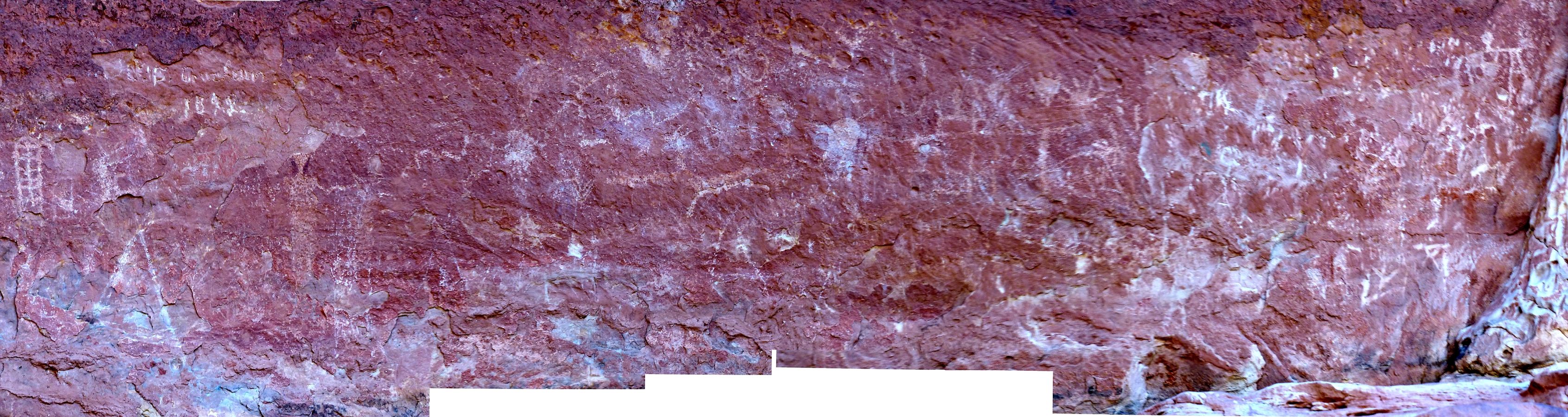
     The petro boulder blazes in the sun, desert varnish pecked to form sandal shapes. Perhaps a guide to the canyon?
     We return from our venture down canyon, to the confluence of Fish and Owl, and then hike up Fish Canyon. Into the land of sand. A slog at times. After a bit over a mile above the confluence, we see the first of the intermittent water in Fish, some pools sporting tadpoles or pollywogs or the tiny fish, namesake of this canyon. The large East wall alcove Fishy Fry Arch rolls into view. I see how it could be missed if one is not scanning the alcoves for arches and other stuff. Yet, the high ruins are even less easily seen than Fishy Fry. A cool front has blown in and it's a pleasant day. Again, the West wall arch eludes me - just where is it and how does one see it? I am wondering if it is visible from the canyon floor. Onward. Beavers have been their busy selves near the East arm junction, forming pools and lining them with discarded chewed willows and cottonwoods.
     As we pause in the shade of a Cottonwood for lunch, nestled in the cool sand, a Towhee and a hummer come to visit. Water is nearly constant as we approach the foot of the climb out of Fish Canyon.
     Bats rule the sky and frogs the amphibian zone.

Day 2 photos - Fish & Owl, 2013

Click thumbnail to see full size image
wfish-owl-2013-day2-1  below confluence.jpg (215175 bytes)

wfish-owl-2013-day2-1 below confluence.jpg

wfish-owl-2013-day2-2  ring.jpg (511793 bytes)

wfish-owl-2013-day2-2 ring.jpg

wfish-owl-2013-day2-3  petro rock.jpg (431755 bytes)

wfish-owl-2013-day2-3 petro rock.jpg

wfish-owl-2013-day2-4  petro rock.jpg (439975 bytes)

wfish-owl-2013-day2-4 petro rock.jpg

wfish-owl-2013-day2-5  Prickly Pear.jpg (226389 bytes)

wfish-owl-2013-day2-5 Prickly Pear.jpg

wfish-owl-2013-day2-6  Prince Plume.jpg (362679 bytes)

wfish-owl-2013-day2-6 Prince Plume.jpg

wfish-owl-2013-day2-7  SD.jpg (277494 bytes)

wfish-owl-2013-day2-7 SD.jpg

wfish-owl-2013-day2-8  Fish view.jpg (404355 bytes)

wfish-owl-2013-day2-8 Fish view.jpg

wfish-owl-2013-day2-9  Fishy Fry.jpg (406089 bytes)

wfish-owl-2013-day2-9 Fishy Fry.jpg

wfish-owl-2013-day2-10  Fishy Fry.jpg (352805 bytes)

wfish-owl-2013-day2-10 Fishy Fry.jpg

wfish-owl-2013-day2-11  Fishy Fry.jpg (448625 bytes)

wfish-owl-2013-day2-11 Fishy Fry.jpg

wfish-owl-2013-day2-12  Fishy.jpg (154588 bytes)

wfish-owl-2013-day2-12 Fishy.jpg

wfish-owl-2013-day2-13  texture.jpg (403757 bytes)

wfish-owl-2013-day2-13 texture.jpg

wfish-owl-2013-day2-14  in Fish.jpg (482525 bytes)

wfish-owl-2013-day2-14 in Fish.jpg

wfish-owl-2013-day2-15  texture.jpg (260969 bytes)

wfish-owl-2013-day2-15 texture.jpg

wfish-owl-2013-day2-16  Mariposa.jpg (216941 bytes)

wfish-owl-2013-day2-16 Mariposa.jpg

wfish-owl-2013-day2-17  beaver.jpg (526962 bytes)

wfish-owl-2013-day2-17 beaver.jpg

wfish-owl-2013-day2-18  Claret Cup.jpg (270753 bytes)

wfish-owl-2013-day2-18 Claret Cup.jpg

wfish-owl-2013-day2-19  dusk camp.jpg (172764 bytes)

wfish-owl-2013-day2-19 dusk camp.jpg

wfish-owl-2013-day2-20  dusk camp.jpg (104472 bytes)

wfish-owl-2013-day2-20 dusk camp.jpg

wfish-owl-2013-day2-21  dusk camp.jpg (108199 bytes)

wfish-owl-2013-day2-21 dusk camp.jpg

(There are - More photos below the trip narrative.)

     Day 3: Brief out: Closing the loop. Visit a secret ruin. 2.5 miles; ERM = 4.5; camp on the mesa.
     It's a steady climb above the fern garden overhang at the end of the Fish Canyon route. Looking back, there are remnants of at least three pueblo walls - these lower in the canyon than most in the Fish-Owl system. Climb. Climb some more. Then, a scramble at the end, 
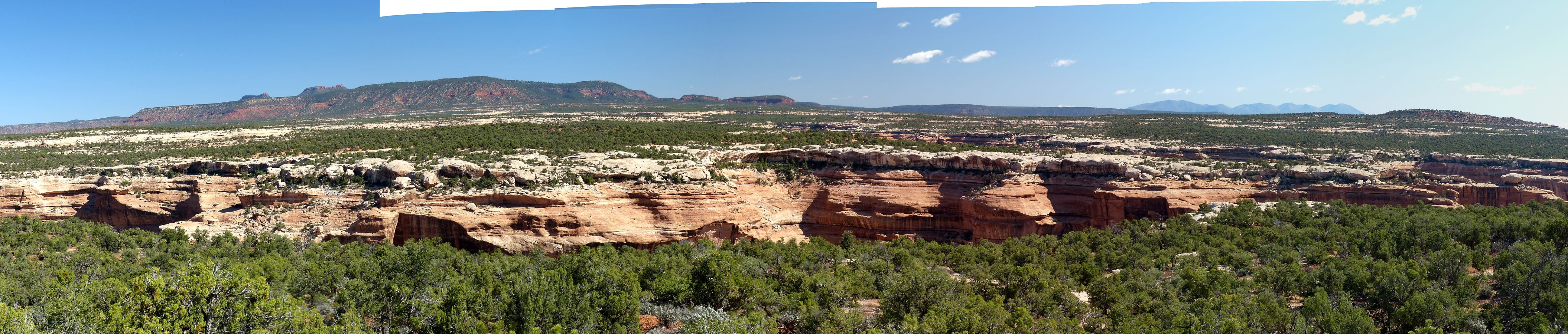
up the crack to the top of the mesa, to see distant Bears Ears above Cedar Mesa. Dramatic.
     A lope through the pygmy forest and we close the Fish-Owl loop.
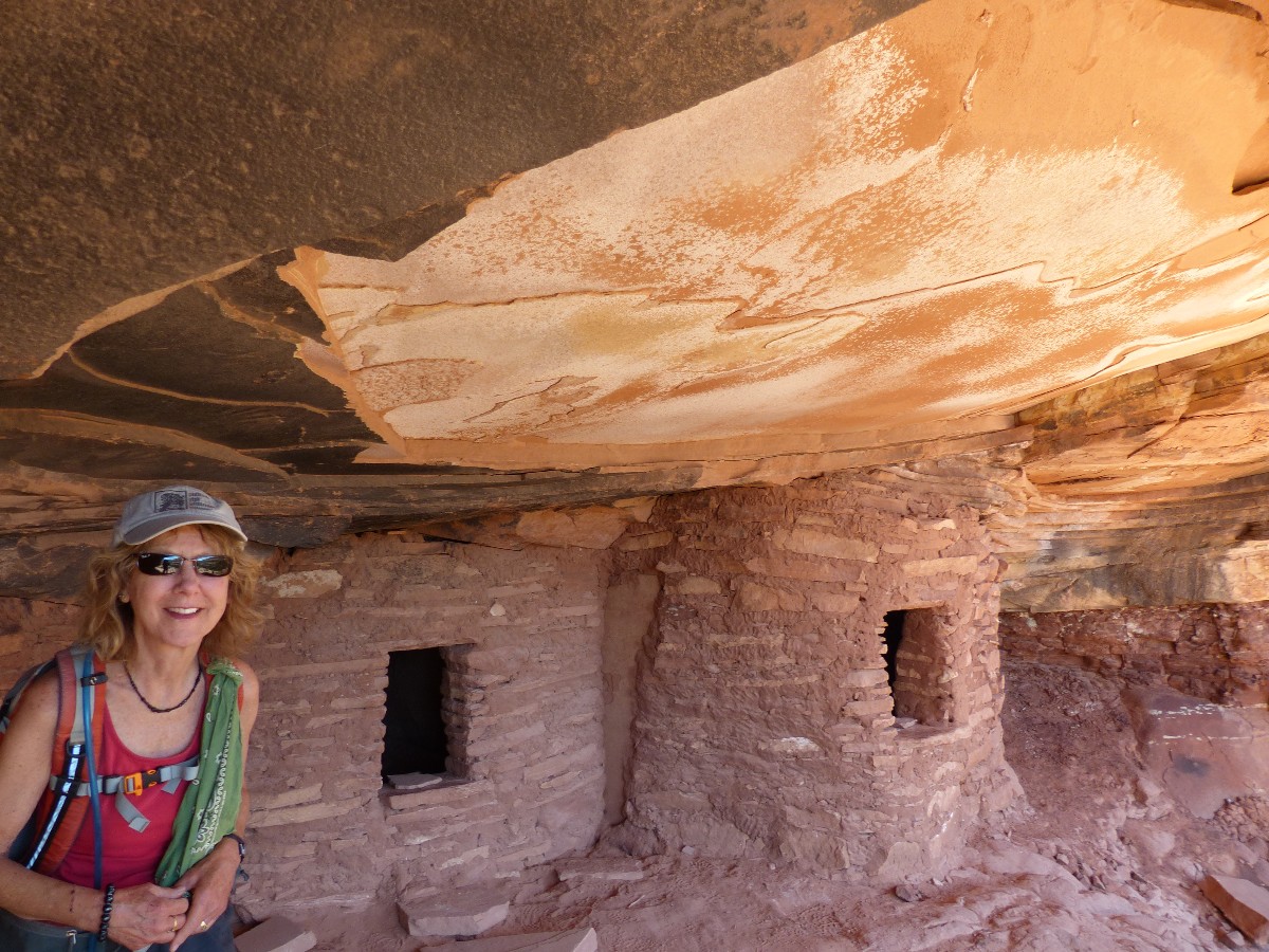
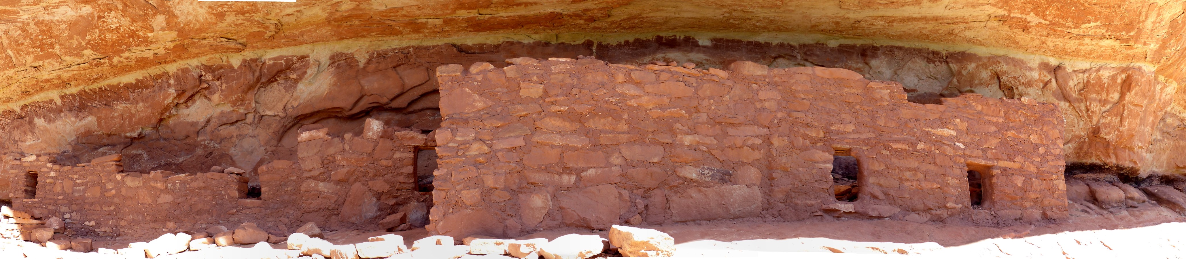
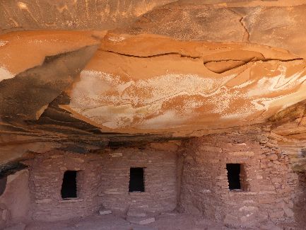
     After a lovely lunch, we venture out on Cigarette Spring Rd. (3.4 mi. to TH) to find a glorious ruin with an art deco ceiling. Secret Ruin. Mystical.

Day 3 photos - Fish & Owl, 2013

Click thumbnail to see full size image
wfish-owl-2013-day3-1  morning.jpg (293680 bytes)

wfish-owl-2013-day3-1 morning.jpg

wfish-owl-2013-day3-2  morning.jpg (275035 bytes)

wfish-owl-2013-day3-2 morning.jpg

wfish-owl-2013-day3-3  morning.jpg (179560 bytes)

wfish-owl-2013-day3-3 morning.jpg

wfish-owl-2013-day3-4  morning.jpg (137899 bytes)

wfish-owl-2013-day3-4 morning.jpg

wfish-owl-2013-day3-5  spring in Fish.jpg (422688 bytes)

wfish-owl-2013-day3-5 spring in Fish.jpg

wfish-owl-2013-day3-6  spring in Fish.jpg (499218 bytes)

wfish-owl-2013-day3-6 spring in Fish.jpg

wfish-owl-2013-day3-7  ruin in Fish.jpg (272163 bytes)

wfish-owl-2013-day3-7 ruin in Fish.jpg

wfish-owl-2013-day3-8  ruin in Fish.jpg (441457 bytes)

wfish-owl-2013-day3-8 ruin in Fish.jpg

wfish-owl-2013-day3-9  climbing out.jpg (401820 bytes)

wfish-owl-2013-day3-9 climbing out.jpg

wfish-owl-2013-day3-10  climbing out.jpg (377281 bytes)

wfish-owl-2013-day3-10 climbing out.jpg

wfish-owl-2013-day3-11  climbing out.jpg (502096 bytes)

wfish-owl-2013-day3-11 climbing out.jpg

wfish-owl-2013-day3-12  climbing out.jpg (318954 bytes)

wfish-owl-2013-day3-12 climbing out.jpg

wfish-owl-2013-day3-13 almost  on rim.jpg (427050 bytes)

wfish-owl-2013-day3-13 almost on rim.jpg

wfish-owl-2013-day3-14  crux move.jpg (225401 bytes)

wfish-owl-2013-day3-14 crux move.jpg

wfish-owl-2013-day3-15  on rim.jpg (400651 bytes)

wfish-owl-2013-day3-15 on rim.jpg

wfish-owl-2013-day3-16  on rim.jpg (404030 bytes)

wfish-owl-2013-day3-16 on rim.jpg

wfish-owl-2013-day3-17  Secret Ruin.jpg (327827 bytes)

wfish-owl-2013-day3-17 Secret Ruin.jpg

wfish-owl-2013-day3-18  Secret Ruin.jpg (316907 bytes)

wfish-owl-2013-day3-18 Secret Ruin.jpg

wfish-owl-2013-day3-19  Secret Ruin.jpg (301018 bytes)

wfish-owl-2013-day3-19 Secret Ruin.jpg

wfish-owl-2013-day3-20  Secret Ruin.jpg (259717 bytes)

wfish-owl-2013-day3-20 Secret Ruin.jpg

wfish-owl-2013-day3-21  Secret Ruin.jpg (292837 bytes)

wfish-owl-2013-day3-21 Secret Ruin.jpg

wfish-owl-2013-day3-22  ancient finger prints.jpg (407520 bytes)

wfish-owl-2013-day3-22 ancient finger prints.jpg

wfish-owl-2013-day3-23  Rattler.jpg (485978 bytes)

wfish-owl-2013-day3-23 Rattler.jpg

wfish-owl-2013-day3-24  Winnifred and friend - Netherlands.jpg (453326 bytes)

wfish-owl-2013-day3-24 Winnifred and friend - Netherlands.jpg

Pano - Bear Ears from top of Fish & Owl
Panorama - Bear Ears from top of Fish & Owl
(Image is very wide and the file large - scroll to view it (4222 x 900;1 mb) - Click the image for the full-size image)

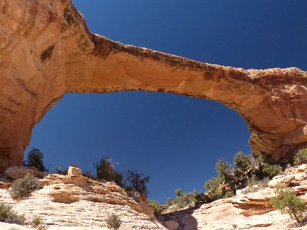
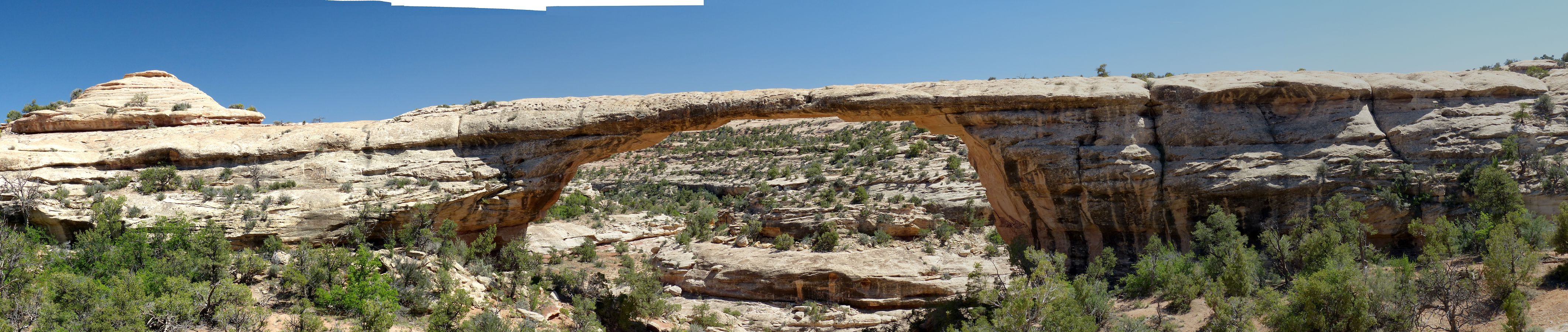
     Day 4: Natural Bridges Loop: 9 miles.
     After driving part of the loop road in the monument, we hike abruptly into White Canyon and to Sipapu Natural Bridge. Along this long loop, we will see three giant NBs (natural bridges, Sipapu, Kachina, Owachomo) and lots of good hiking. Horse Collar Ruin and the pictos and petros near the buttress of Kachina NB are added features. During a lunch break, a storm of geology students ripples past. Over 50 in this group. Ahh, field research. 
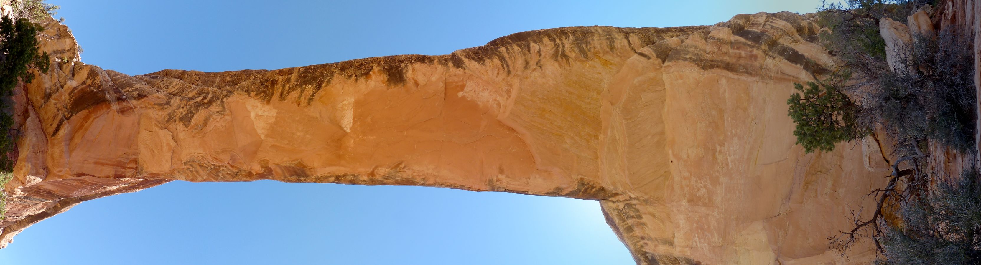
Continuing past another high panel of art, we climb out under and through Owahomo NB, and return to where we parked on the mesa top trail. Gorgeous.

Day 4 photos - Natural Bridges NM, 2013

Click thumbnail to see full size image
wfish-owl-2013-day4-1  into White Can.jpg (381058 bytes)

wfish-owl-2013-day4-1 into White Can.jpg

wfish-owl-2013-day4-2  first look Sipapu.jpg (431417 bytes)

wfish-owl-2013-day4-2 first look Sipapu.jpg

wfish-owl-2013-day4-3  down climb.jpg (493518 bytes)

wfish-owl-2013-day4-3 down climb.jpg

wfish-owl-2013-day4-4  Sipapu NB.jpg (381147 bytes)

wfish-owl-2013-day4-4 Sipapu NB.jpg

wfish-owl-2013-day4-5  Sipapu NB.jpg (308454 bytes)

wfish-owl-2013-day4-5 Sipapu NB.jpg

wfish-owl-2013-day4-6  Sipapu NB.jpg (338041 bytes)

wfish-owl-2013-day4-6 Sipapu NB.jpg

wfish-owl-2013-day4-7  Horse Collar.jpg (347347 bytes)

wfish-owl-2013-day4-7 Horse Collar.jpg

wfish-owl-2013-day4-8  Horse Collar.jpg (310353 bytes)

wfish-owl-2013-day4-8 Horse Collar.jpg

wfish-owl-2013-day4-9  near Kachina.jpg (460400 bytes)

wfish-owl-2013-day4-9 near Kachina.jpg

wfish-owl-2013-day4-10   Kachina.jpg (459545 bytes)

wfish-owl-2013-day4-10 Kachina.jpg

wfish-owl-2013-day4-11  rock art.jpg (318421 bytes)

wfish-owl-2013-day4-11 rock art.jpg

wfish-owl-2013-day4-12  Kachina NB.jpg (287778 bytes)

wfish-owl-2013-day4-12 Kachina NB.jpg

wfish-owl-2013-day4-13  rock art.jpg (362019 bytes)

wfish-owl-2013-day4-13 rock art.jpg

wfish-owl-2013-day4-14  ruin.jpg (246592 bytes)

wfish-owl-2013-day4-14 ruin.jpg

wfish-owl-2013-day4-15  NB in Armstrong.jpg (512535 bytes)

wfish-owl-2013-day4-15 NB in Armstrong.jpg

wfish-owl-2013-day4-16  panel below Kachina.jpg (228564 bytes)

wfish-owl-2013-day4-16 panel below Kachina.jpg

wfish-owl-2013-day4-17  Owachomo NB.jpg (291552 bytes)

wfish-owl-2013-day4-17 Owachomo NB.jpg

wfish-owl-2013-day4-18  Owachomo NB.jpg (343680 bytes)

wfish-owl-2013-day4-18 Owachomo NB.jpg

Pano - Petros & Pictos on buttress of Kachin NP in Bridges Loop
Panorama - Petros & Pictos on buttress of Kachin NP in Bridges Loop
(Image is very wide and the file large - scroll to view it (3381 x 900;828 kb) - Click the image for the full-size image)

Pano - Petros & Pictos in Bridges Loop
Panorama - Petros & Pictos in Bridges Loop
(Image is very wide and the file large - scroll to view it (4430 x 900;716 kb) - Click the image for the full-size image)

Movie - Owachomo NB
Movie - Owachomo NB - 9.5 MB
(Click the image to see the short video)

Pano - Owachomo NB
Panorama - Owachomo NB
(Image is very wide and the file large - scroll to view it (4246 x 900;992 kb) - Click the image for the full-size image)

Pano - under Owachomo NB
Panorama - under Owachomo NB
(Image is very wide and the file large - scroll to view it (3328 x 900;381 kb) - Click the image for the full-size image)

More Truth than Joke:

SS is not the issue, greed is
(Click the image for the full-size image)

Working class gets conned in scam favoring the rich (Social Security)

Pro-profit, not pro-life.
(Click the image for the full-size image)

stop abortion
stop abortion.
(Click the image for the full-size image)

Who has the best imaginary friends?
(Click the image for the full-size image)

separation of church and state
The Constitution and separation of church and state
(Click the image for the full-size image)

Links:

Map:

Map - Fish & Owl loop 2013; 20 miles
(Click the image to see the map)

for a full-resolution map, click here. Caution - do not use this map or gps track for navigating the route.

Fish and Owl loop: Right Click (then save this file: "save link as..." in most browsers) on this Download link to get the GPX file from my GPS - you can then open it in your mapping software. Note - that's a Right Click on this link. You will get the track for your software shown in the map above.

Book:

Peter Francis Tassoni (2001) A Hiking Guide to Cedar Mesa: Southeast Utah, University of Utah Press.

Previous WV Reports about The Area:

Grand Gulch Grandioso: Kane RS to Pour-off near San Juan River and out Collins Canyon TH, 2011

Bucolic Butler Wash: Ruins or ruination? Butler Wash – Cedar Mesa area, Utah, 2009

Dare to say Dark Canyon: Dark Canyon 2008: Horse Pasture to Sundance Trail - with after-backpack excursions to Upper Salt Creek and Natural Bridges, 2008

Cedar Mesa Somewhere - Hiking the Trails of the Ancients, 2001

Pictographs and Petroglyphs
Or - my life is in Ruins!
Assorted images from all over, with some images of Pueblo structures

Related Sites:

Click here to see the BLM brochure about Fish & Owl pdf file

Click here to see Alum water treatment for backpackers - summary by John Ladd.

Scenic Toilets of Inner Earth: Scenic Scatology of the Wilderness Vagabond

Bill Mckibben - climate change and the flood this time.

Working class gets conned in scam favoring the rich (Social Security)

We Are Breeding Ourselves to Extinction (click here for full article)

All measures to thwart the degradation and destruction of our ecosystem will be useless if we do not cut population growth. By 2050, if we continue to reproduce at the current rate, the planet will have between 8 billion and 10 billion people, according to a recent U.N. forecast. This is a 50 percent increase. And yet government-commissioned reviews, such as the Stern report in Britain, do not mention the word population. Books and documentaries that deal with the climate crisis, including Al Gore’s “An Inconvenient Truth,” fail to discuss the danger of population growth. This omission is odd, given that a doubling in population, even if we cut back on the use of fossil fuels, shut down all our coal-burning power plants and build seas of wind turbines, will plunge us into an age of extinction and desolation unseen since the end of the Mesozoic era, 65 million years ago, when the dinosaurs disappeared.

We are experiencing an accelerated obliteration of the planet’s life-forms—an estimated 8,760 species die off per year—because, simply put, there are too many people. Most of these extinctions are the direct result of the expanding need for energy, housing, food and other resources. The Yangtze River dolphin, Atlantic gray whale, West African black rhino, Merriam’s elk, California grizzly bear, silver trout, blue pike and dusky seaside sparrow are all victims of human overpopulation. Population growth, as E.O. Wilson says, is “the monster on the land.” Species are vanishing at a rate of a hundred to a thousand times faster than they did before the arrival of humans. If the current rate of extinction continues, Homo sapiens will be one of the few life-forms left on the planet, its members scrambling violently among themselves for water, food, fossil fuels and perhaps air until they too disappear. Humanity, Wilson says, is leaving the Cenozoic, the age of mammals, and entering the Eremozoic—the era of solitude. As long as the Earth is viewed as the personal property of the human race, a belief embraced by everyone from born-again Christians to Marxists to free-market economists, we are destined to soon inhabit a biological wasteland.


Wild Vagabond Main   Trip Report Index   Caveat