
|
| |||||

|
| |||||


|
| |||||


| ||||
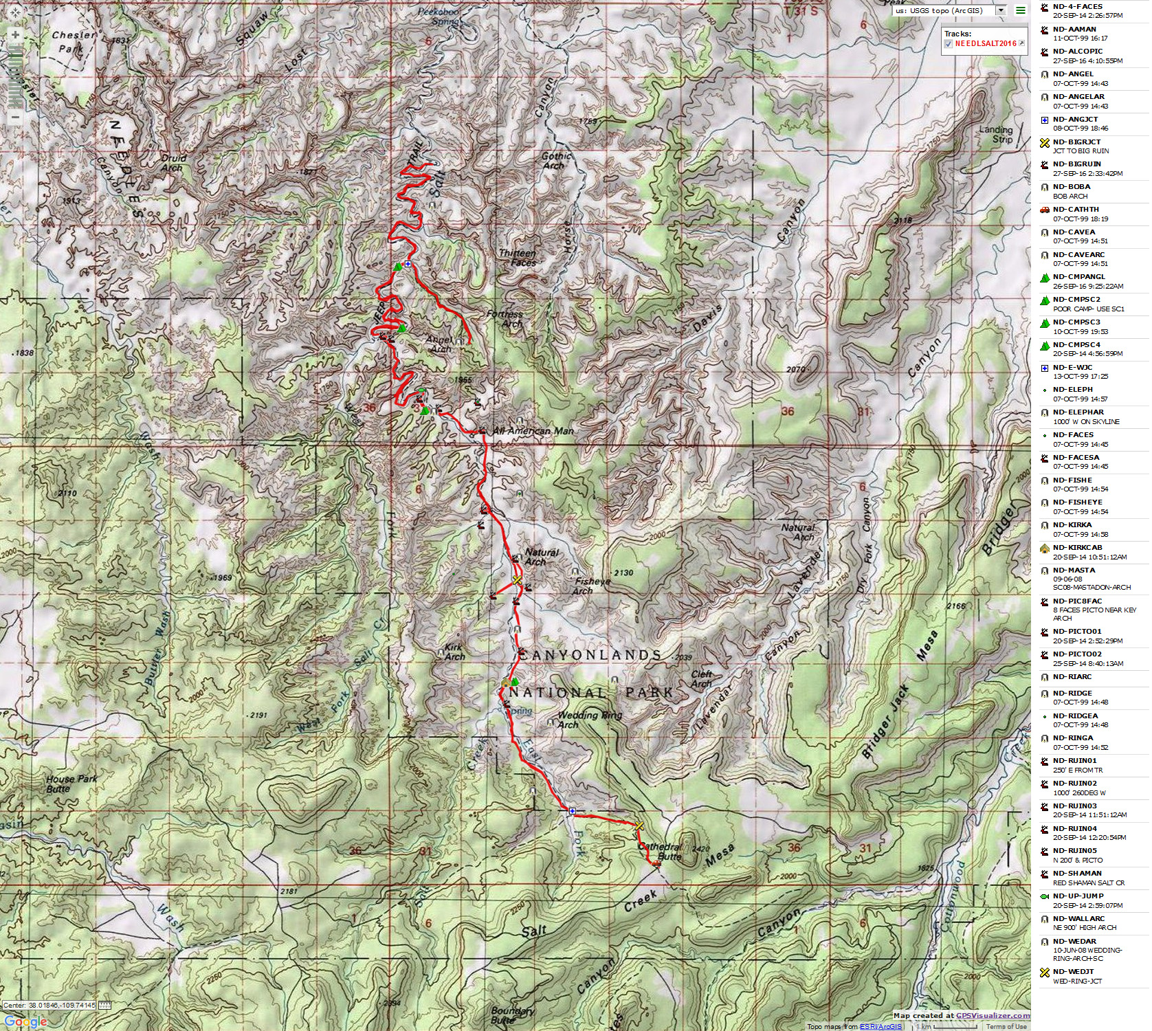
GPS track shown in above map. Right click on this link to get the track (not the map) for use in your mapping software.
| ||||
| ||||

Needles District of Canyonlands National Park
Visiting SC3, the Salt-Horse Zone, Angel Arch
|
| |||||
|
| |||||
|
| |||||
| ||||
GPS track shown in above map. Right click on this link to get the track (not the map) for use in your mapping software.
| ||||
| ||||
Background: This is a follow-up trip to the 2014
Knocked About In The Needles District
(click here for this report), where I broke my ankle, fracturing the adventure. I
wanted to finish and extend this fracture adventure, so I applied for an Upper Salt Creek
backpack permit and hit the trail.
You will not see waypoints for any of the archeological features (e.g.,
ruins, pictos, petros) in the report maps. You will see references to camps and arches.
If you hike the Needles District in the Fall, I suggest you are mindful
of the vegetation growth created by a decent monsoon (series of desert thunderstorms) and plan your
equipment for a thrashorama. It's a lot different than Spring hiking in this same area.
47 miles; ERM = 64
Co-adventurers: 0 (solo trip)
camera: Panasonic DMC-ZS19
Prelim; Day 0: Cathedral Butte Bound:
To Salt Creek South TH. Camp @ 7100'.
The weather forecast disintegrates as departure time approaches,
increasingly greater chances of rain, possible thunderstorms. Even a chance of snow at the North
Long Point weather station in the Abajo Mountains. "Yikes!" I mutter with trepidation. In addition,
a call to the Needles District Ranger Station reveals cautions about thick vegetation and lost hikers.
There's no mention of the fire closure near the junction of Upper Salt and the Angel Arch arm until
I successfully bump up the Beef Basin Road to the Cathedral Butte TH and read the TH sign. Not good,
the closed area appears to be fairly broad and includes a wide zone from SC4 to far below the Angel
Arch junction. Drat.
I start setting up camp, then retreat to the truck as a series of
light rains surge across the plateau. No issues, I listen to a Jack Reacher audio book while water
dribbles off the truck shell. Back to sprawling in the camp chair, I cook dinner as clouds obscure
the waning sun, happy that I drove up the 18 miles of dirt and clay prior to the spitting storms,
which so far are not enough to make travel difficult. There was one other vehicle near the TH, and
it left toward Natural Bridges via this Elk Ridge Road near sunset. To bed with nearby winds prowling
through the Pinyon-Juniper Pygmy Forest.
"Reality has a well-known liberal bias." - Stephen Colbert
Day 1: Four Faces of SC3. To Salt Creek Camp 3 (SC3) :
Cathedral Butte TH (Trail Head; about 7,000') to SC3; 9.5 miles. ERM = 12.5. Camp @ 5700'.
The well-dressed figures smile down at me, the lone hiker in Upper
Salt Creek today, as clouds boil above the Cedar Mesa Sandstone walls framing this lovely canyon system.
Rain spatters briefly as the Faces watch me filtering water and gathering a bucket of water for a bath.
It's been an unsettled day with a vigorous wind rushing dark clouds over Canyonlands.
This morning, the wind was raging as I dropped off the high point near
Cathedral Butte and into Upper Salt Creek. After wading through the first jungle of reeds and willows,
I arrive at the lovely spring above Kirk's Cabin and stop for an early lunch #1. The wind attempts to
disperse my lunch items throughout the canyon, but I successfully retrieve them all. Kirk Arch, Elephant
Trunk, Ring, a couple of unnamed arches, ruins, distant pictos sheltered under rock overhangs, gorgeous
stuff. I pause for lunch #2 at the All American Man, thankful for the rest before the last mile to SC3.
Then, another jungle of reeds before reaching the upper cascade that
precedes Upper Jump. One cannot see where they are going in this patch of reeds, or how good is the
footing either. Good water cascades over slickrock and drops into a pool below the SC3 spring, where
the water looks deep enough to submerge a camel.
I set up camp and realize I've forgotten my binoculars for spotting
ruins, alum, and my drink mixes. Argh. I can and will do without, yet miss these items all the same,
especially the binoculars.
A light rain pesters me at dinner, and eventually chases me into the
tent just before sunset. Thunder rumbles in the canyon arms to the South. With very modest wandering,
the daily mileage is 9.5.
Goodnight from under a gracious Gamble Oak at SC3.
 |
 |
 |
 |
 |
 |
 |
 |
 |
 |
 |
 |
 |
 |
 |
| ||||
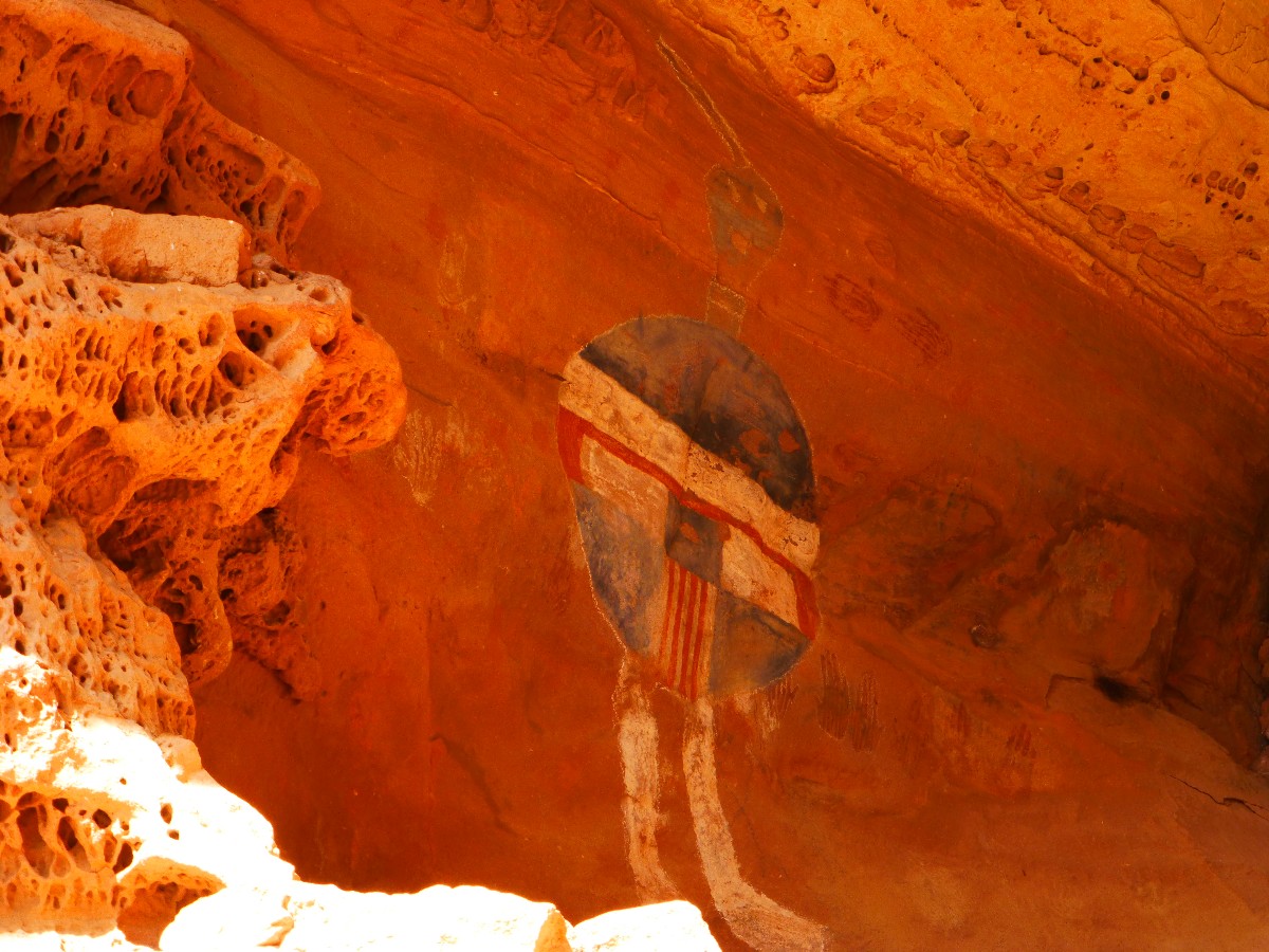
Day 2: Almost An Angel. To near Angel Arch junction: 6 miles. ERM = 8. Camp @ 5400'.
Yikes, there's 20 feet of vine following me, caught in the pack. Thrashing
through the monsoonal vegetation growth is slow and it's easy to get off course. Sometimes there is no course.
Once again, I miss an obscure turn and flounder for awhile before finding a rutted watercourse that is the
route. Popping out onto the bench below the ledge ruins, I look in vain for the Shaman, yet enjoy the other
pictos and the structures. One ruin, hidden in a small recess, is so well preserved that one can still see
the ancient craftswomen fingerprints in the mortar. Wondrous. Then, back in the drainage to SC4, and past
what appears to be high stranded rincon. The few times that I can see much of the canyon walls, there are
usually ruins to be seen. So much to explore, and little time because of my slow pace. The going is
intermittently smooth and open as I work my way to the burned area just upstream from the Angel Arch
junction. The old vehicle sign remains at the junction, a reminder of the repeated fights to remove
then keep out vehicles from Upper Salt Creek. The ORV blue smoke crowd insisted that Salt Creek is a
developed road, while the Park and conservationists cited the oil and damage to the ecosystem.
I invest extra time in finding a tent site somewhat protected from the
prying wind and from the sun. I believe that I'm not far from the location of the old Bates Wilson camp,
removed when the jeep road was abandoned. A large Cottonwood and several mounds of brush provide shelter
for a decent tent spot, although the kitchen is out in the wind alley. Good enough, and I'm hoping for
nicer weather after today.
For the second day, I see no one and no fresh tracks.
Last night, the wind howled and it intermittently rained throughout the
night. I sleep in and the wind drops to near calm for breakfast. The sky starts to shed clouds, yet I'm
still OK with toting the heavier rain pants because of the specter of floundering through the wet reeds
and brush. I hang up the tent in the tree to dry and unfurl the solar roll to charge when the sun struggles
free about 8:30 a.m. It warms and all the warm clothes go into the pack. Glorious.
However, there's nearly always a however, the wind returns and so do the
clouds, making it chilly in the shade.
Now in camp 2, it's cool enough that I retire to the tent to finish these
journal notes, finding that the wool hat feels fine.
 |
 |
 |
 |
 |
 |
 |
 |
 |
Day 3: Arching Angel. To Angel Arch and rincon exploring: 7 miles. ERM = 9. Camp @ 5400'.
Deafeningly quiet. That's how the morning begins. Stationary clouds
have silently lidded the Canyonlands and it's eerily quiet.
I refill all the water containers and batten down the camp before heading
to Angel Arch. There are still erosion sections from the long ago ORVs grinding up Angel Arch Canyon,
the rock jumbles making an uneven walk. Then, parts are clogged with brush before a trail heads out of
the drainage and to the base of Molar Rock, curiously balanced on a sandstone wave. Behind it and high
on a lip of the wall arches Angel Arch. The arch beckons.
I recall a route to beneath the arch, and that it contains some climby
challenges. I set out after unrolling the solar collector (hoping for full sun) and soon pick up a route
marked with rock cairns. There is one rounded slickrock friction gription and a few other clingons on the
way to the buttresses of the arch. I pat the Angel Arch buttress for my good friend Bob F., The Archman,
this was one of his favorite arches. The sky has cleared enough that the gorgeous robin egg blue provides
a terrific backdrop.
Back at Molar Rock, I enjoy lunch in a small alcove that protects from the
brisk wind and is shallow enough for the feet to be in the intermittent sun.
Back at the Salt-Angel junction, I drift down canyon and inspect what was
once the Angel Arch Camp (probably an historic camp, later a vehicle camp, most recently a hiker camp).
Toasted to ash.
Back in camp, I inspect the map and go to explore the Rincon just upstream,
and find only low destroyed walls. Continuing across canyon, I climb to the ledge and find little, and
follow the ledge around the nose of the fin and into the park just above camp. There are ruins on an unscalable
ledge where one can see remnants of what might have been a climbing tower. Not today.
Cold unproductive storm squalls pulse through all day. T-shirt, long
sleeve, wind jacket, back to t-shirt, etc. It's a clothing rotation all day long.
A few Cottonwood leafs are sporting their Fall yellow. At sunset the
canyon sports yellow, some salmon, vivid.
 |
 |
 |
 |
 |
 |
 |
 |
 |
 |
 |
 |
Day 4: Salt Salutation. Down to no particular place in Salt Creek: 7.5 miles. ERM = 9.5. Camp @ 5400'.
It's a brisk and clear, for the first morning, day. Chilly in the shade
and delightful in the sun.
Down Salt Creek I hike, past the Kissing Cows Arch, winding serpent-like,
meander after meander. I observe that the fire was concentrated at the Angel Arch junction and didn't extend
far in either canyon. I see Kirk Fence, apparently where Kirk, homesteader prior to the declaration of
Canyonlands National Park, found this narrow spot in the canyon easy to fence off. Obliging canyon walls
provided the rest of the barrier. A bit of work to form a natural corral.
I continue for awhile, then start back, pausing in a low alcove for a
leisurely lunch. The section I hike today is more easily traversed than the jungle section between Angel
Arch junction and SC3. It also seems less studded with ruins and pictos. Sections where the jeep road
once cut across slightly higher benches remain somewhat intact, and make for easy traveling. Perhaps the
canyon is a bit wider, allowing parts to dry out and cut down on the vegetation growth? Maybe the flow
of water is less consistent along here?
For the fourth day, I see no one else. Yet the Ravens talk at me as I
pass their observation rocks.
 |
 |
 |
Day 5: SC3 Shaman Return. To SC3: 6 miles. ERM = 8. Camp @ 5700'.
It's a frosty morning, requiring the full regalia of clothing (all
the clothing you have), plus gloves. It's clear and crisp and quiet.
I set out on another Shaman quest, thrash through the jungle past SC4
and pause for lunch #1 before scouring the slickrock, ledges, and hoodoos for the haunting pictograph I
feel is The Shaman. How could I have missed finding it on the way down? It is The Shaman, yet is it
also a shape-shifter? And, I recall being out exploring anew a couple of years ago when I turned and was
face to shocking Shaman. Mystical. Will some walking meditation free the mind of rust and allow animal
magnetism to pull me to The Shaman?
So, I look high and low then farther where I previously looked, and there
is The Shaman! Yoweee. I feel complete.
Then, lunch #2 followed by more thrashing and route finding issues, the
dense grass, horsetail, willows, tamarisk, vines, thistles, reeds, young Cottonwood, other stuff grabbing
at my boots, the pack, body parts. Argh. It's easy to miss a turn in this vegetation mire.
Viewed from SC3, the Neapolitan colors bask in the low angle of sunset.
I'm happy to switch to the cleaner, nearly Sierra-like water near SC3, leaving behind the tannin-infused
brown brine of lower Salt Creek. Where did the name "Salt Creek" originate anyway? My stomach gurgles
agreement. All is right in this canyon camp; alpine spaghetti with cocoa, excellent camp and vistas,
quiet except for the occasional McCain-Reed jet overflights, you know, the noise that doesn't count as
noise (only from the profit point of air tour terrorists in The Grand Canyon). Solitude. Yet, there
are new footprints in my camp since I was last here, indicating that at least one other person is skulking
the canyon. But I see no one but the little brown bat collecting bugs and swooping about me like a
midget satellite as I enjoy an after sunset stroll to the Four Faces.
 |
 |
 |
 |
 |
 |
| ||||
Day 6: Ruination Ramble. To SC1: 7 miles (plus perhaps 4 exploring). ERM = 9. Camp @ 5870'.
About 8 a.m. the sun reaches camp and then the day warms. Just good
solar load at first, then some warmth. The early light brings forth the color hues in the Cedar Mesa
Sandstone. Spectacular. Slightly chilled fingers are transformed into working digits.
It's cool enough to wear a long-sleeved shirt for the brief thrash
through the reeds, and it's too hot to wear by the All American Man.
I pause to search for a hidden panel I call The Eight Faces, which
was unexpectedly found while arch hunting many years ago. I look for the fallen arch, then start crawling
through rock cracks and come face to Eight Faces. Fallen arch? Maybe, all that remain are suspicious-looking
buttresses from which one can imagine an arch arching high above.
I come literally face to face with the faces in tight confines as I lilt
around the corner of a rock wall. The crack is narrow enough that it's difficult to include all the faces
in a photo. It appears that the art work for the faces is incomplete, either that or they have faded
substantially over the past 800 years or so. Either way, it's a wonderful discovery.
I then head for what might be called The Big Ruin because of the number of
structures laid out along a high ledge, one that is inaccessible to all but the climbing elite. It looks
possible to get up on the ledge, and I am not sure about coming back down. The Big Ruin is across the
canyon from the trail. People, apparently trying to be helpful, and in the process destroying the
archeological value, have collected pot shards of a wide range of construction and color schemes and
arranged them on a rock. There's also a broken metate.
A bit farther, and I wade the sage into an alcove and find two picto panels.
Now getting late, I head for the Kirk's Cabin area and camp. It's a
pleasant evening, but for some bandit campers, the first people seen in 6 days, making too much noise
somewhere in the rocks by Kirk's Cabin.
Deep dark of 9 p.m. brings forth the glare and glitter of the Milky Way
and billions of its accompanying stars. It's an excellent last night in Upper Salt Creek.
 |
 |
 |
 |
 |
 |
 |
 |
 |
 |
 |
 |
| ||||
| ||||
Day 7: Cathedral Climb. To Cathedral Butte TH: 4 miles. ERM = 8.
In the contemplative crepuscular time prior to the arrival of the sun,
I sit on my sandstone bench at SC1 and contemplate a trip well hiked. Again, it's total natural quiet, a
peaceful alternative to life with constant noise, light that eliminates the stars, and a visual desolation
wrought by corporations of the bland (yet greedy beyond bounds), and so many people, people hurrying here,
there, so many and on a devastating line of geometric progression population explosion that makes rabbits
hide in shame. Except for the (some) women, gorgeous works of art beautifying the world.
It is a brief climb up to the TH, through the reed jungle and out of
the Cedar Mesa Sandstone and the Cutler Formation. To the Beef Basin/Elk Ridge Road and off the Plateau,
home, after fulfilling the Thrashorama in Upper Salt Creek.
 |
 |
 |
.
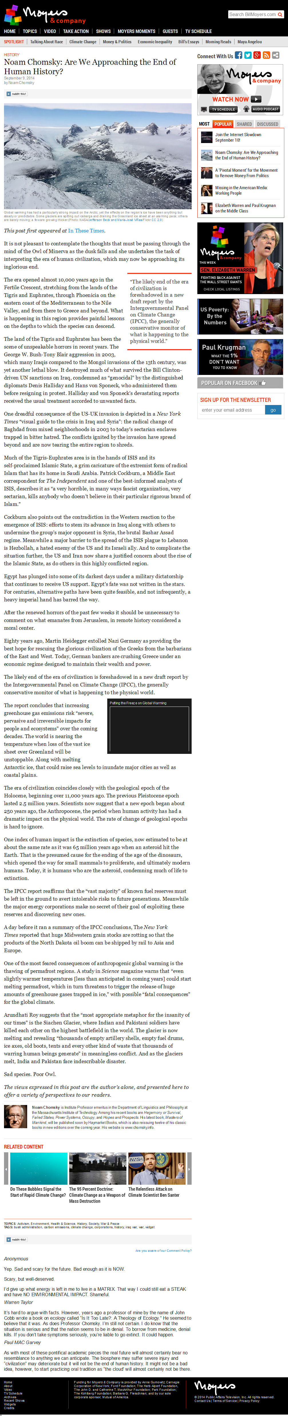
Chomsky: Are We Approaching the End of Human History (article, 2.3 mb)
Needles Knocked About: Misadventure in Upper Salt Creek and your PLB, 2014
Maze 2013: Marauding the A-Mazing Marvelous Maze, 9-day backpack, 2013
Triple Flushing The Magnificent Maze: Exploring The South Fork area of THE Maze, 2010
A-Mazing Maze, a Desert Solitaire: Exploring The Fins Area of Canyonlands NP, 2009
Snowfest attempt in THE Maze, 2009
Disraeli Gears: Bicycling The White Rim of Canyonlands N. P., 1999
Jointly To The Needles: Dayhiking in The Needles District of Canyonlands N.P., 1998
| ||||
| ||||
| ||||
| ||||
| ||||
| ||||
| ||||
| ||||
| ||||
|
Wild Vagabond Main |
Trip Report Index  |
Caveat  |
|---|


