|
|
|
The Canyonlands N.P. home page is:http://www.nps.gov/cany
It really is THE Maze! I have been fascinated with this district of Canyonlands since I read about it in Ed Abbeys Desert Solitaire in the 1970's. The country IS as deluxe as Abbey describes it. There are many exotic, wild places on the Colorado Plateau, but, because it was my first deeply wild experience in this desert country, THE Maze remains one of my favorites. This was my 11th visit to THE Maze, and I wouldnt mind going back again...each experience is rejuvenating and different.
|
Wild Vagabond Main |
Trip Report Index  |
Caveat  |
|---|
Night 1: Rooster Howl: I left Tuesday night, bound for THE Maze. I had considered the Escalante, the Kolob heights, and other options, but found them snow-bound.
I drove south in light traffic, passing elk in Spanish Fork Canyon. Refilling coffee in Beef Wellington, gas in Green River, the silence of the road continued onto the 50+ miles of dirt to near Hans Flat R.S., where I camped on a side road. Stepping out of the pick-up, I sunk into fluffy soil. The desert duff is invigorated during winter, internally expanded by frost action. Cleansing the desert, this frost action helps remove foot and vehicle tracks. Its a different type of spring cleaning.
|
Day 1: Plugged In: Flint Trail to the Main Arm, MAZE: Howling coyotes reminded me that it was time to get up and going. A few snow flakes told me it was still early Spring on the high plateau (I'm about 6,500' near the R.S.).
I registered at the R.S., then continued along the rim of the Orange Cliffs to the top of the Flint Trail. I saw a brother coyote along the way, his fluffy tail swaying in the breeze. My original plan was to hike down the Flint Trail and then the Golden Stairs, perhaps making it to the South Arm of THE Maze...
It was warmer than the occasional snowflake
would suggest, and I wore shorts as I packed on slickrock behind the
parking pull-out at the head of the Flint. I walked part of the Flint,
then decided to drive down the Flint to the TH (trail head) above the Golden
Stairs. It was a bit rough, but it saved me some time, time I found I
really needed.
I began hiking around 1 p.m., and
would camp in the main arm of THE Maze about 8.p.m., in the rapidly
dimming twilight. As I began the drop off the whale-nose at the head of
the Golden Stairs, I slipped on some wet clay, rolled an ankle, and my
behemoth pack rolled over me and down the side hill, with me attached.
A large gash appeared in the palm of my hand. I looked up at a juniper
swaying in the breeze, paused, and wondered if I had other injuries. A
bit shaken and feeling like I just exited a tumble dryer, I found I had
no permanent damage. The next rain spatters helped wash off the blood.
At the foot of the Golden Stairs, I
began the long stroll over to The Land of Standing Rocks. Hidden from sight
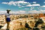
was THE Maze, my destination. What one sees as they round the high cliffs
is a rippling expanse of Cedar Mesa Sandstone, without hint of the intricate
labyrinth folded in the ripples.
My feet were becoming bruised as I
slumped near Lizard Rock. The sun is getting low and I still have to locate
and go down the Plug route and into THE Maze.... Grunting to a slouch,
I continued past Lizard and found the route down. Around alcoves, over
low divides between the array of arms of the Main Maze arm I inched, eventually
reaching the canyon floor. It was getting dark. Although I wanted to stop,
I also wanted to continue hiking until I found water. I stopped as dark
quickly collapsed in the narrow canyon. After collapsing for awhile, I went down
canyon and found
The Haven Spring (local moniker, named on an earlier Smegma Brothers trip).
Here I am, sprawled on a narrow
sand strip, with the tent shrouded by a Utah Juniper, and sweet water from
Haven Spring puffing in the cooking pot. I thought, feet can be flat but....
Life is good.
Day 2:
Overlooking the Past:
Main Arm Maze to the Harvest Scene, & THE Maze Overlook: It is warm
and delightful in this solitary canyon. I began the down-canyon walk to
the Harvest Scene, a wonderful panel of Barrier Canyon era pictographs, passing several intermittent springs along the way. The canyon solitude
continued as I passed a multiplicity of canyon arms, to the left, to the
right, quite a confusing place, this Maze. Of course, its not a problem
going down-canyon, but when traveling upcanyon, one might be easily confused
by the big arms like Chimney Rock, for the outflow in these arms rivals
that from the main arm in size and general direction.
After establishing camp in the Harvest
Scene vicinity, I lunch-lounged under a budding cottonwood tree, then
day-hiked around the horn, into the South Arm, and up through layers of
geologic time to THE Maze Overlook. One would think that the unique nuts-and-bolts
formations of the White Rim Sandstone (the nuts) and the dark chocolate
of the Organ Rock Shale necks below (the bolts) would readily mark the
Overlook. But NO, there are several versions of this feature along the
rim of the South Arm. Heres another reason to call it THE Maze. I hiked
and scrambled up to the Overlook, in places using moqui steps pecked into
the sloping slickrock billows. Its not the obvious route. Great vistas
reward the climber, however. The Chocolate Drops, fin-like nuts-and-bolts,
protrude from a thin ridge into the aquamarine sky spanning the South Arm.
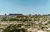
The contorted, convoluted canyons of THE Maze flow like ripples on a sandstone
ocean, bounded by the distant shores of the Abajo Mountains and Big Elk
Ridge.
Day 3:
Chimney Loop:
Today I would day-hike out of THE Maze, along the ridge separating THE
Maze from Jasper Canyon, to Chimney Rock, then into the Chimney Rock Arm
of THE Maze and back to camp. Whew, it was a long day, and I felt like a tired lizard
when I returned to camp.
|
I filled all my water bottles at the main spring, near where THE Maze becomes Horse Canyon and continues its eventual trip to the Green River. Then, I followed chaotic cairns up to the ridge between Chimney Rock and Petes Mesa. I was hoping to see some of the rare Bighorn Sheep that prowl the mesa, but no such luck today. This is an easy route, if the markers are in place. Stopping for lunch on the warming rock, I noted that cirrus clouds were flying across the robin egg blue sky. What does this portend? Continuing along the ridge to Chimney, I peered down into now forbidden Jasper Canyon. The Park Service has placed it off-limits because it was one of the few ungrazed canyons, and the abundant historical stuff had yet to be catalogued, and because one of those less-than-adequate Kelsey guides had made it too popular. (Take heed, do some conservation work today, and keep the wild parts of your public land.)
I explored the entrance to Shot Canyon. I found the sandstone steps spiraling down a deep bowl that were, unbelievably, the entrance to the canyon for livestock. And, I located the route into the Chimney Arm, making my return route shorter and more interesting. I looped back into the Main Arm of THE Maze, popping out into the main arm not far from camp. The bats plied the skies and the vultures swirled back to their roost as the sun set over canyon country.
Day 4: Chocolate Gale: Main Arm to the top of the Golden Stairs. Blisters. Blisters marked the day for me. My plan was to hike out the Chocolate Drops route, overnight at Sheepeater Spring, then go home tomorrow. But, a gale-force wind began as I climbed over the rim to the base of the Drops. "Its sunny with pure wind," I noted. This route to the base of the Drops has been removed from the new maps, but I have an old map. There is value in old things. A rangerette later told me that the route had been removed because several parties got stranded going up or down this route. I can see why. There are two occasions, that some would climb easily, but not with full packs. .
After a lovely lunch in the lee of the Drops, peering across the space of the South Arm at THE Maze Overlook, I slogged the long ridge route to Kissing Rock, and the Land of Standing Rocks. In search of a wind-break for another gorp stop, I picked the wrong place and the wind filled my mouth with grit with the first bite. On and on, (and on!) I wobbled in the head-wind as I slogged the jeep road to the foot of the Golden Stairs.
Finally, I strained to the top of the Stairs. Its growing a darker shade of gray as the cirrus-forecast front closes in on canyon country. I was almost blown off the narrow whale rock separating two large basins as I neared the TH.
Fearing the slip and slide of gumbo clay, I crept back up the Flint Trail and to the long-closed ranger station. It was ebony dark and the wind was blowing hard. Rather than camp on the rim (remember the 50+ miles of dirt road?), I headed back to Green River. It was a hypnotic drive, swirling chocolate dust swam and slithered along the road surface, blotting anything in the distance, and sometimes everything near too. I did see a Kit Fox floating along the side of the road, amazed by how it danced light-footed in the headlight glare. Surely, the air filter in the pick-up was clogged by now. Eventually, I reached the highway, then continued to Green River. The clouds in this sector had parted enough that the moonlight illuminated the glinting teeth of the San Rafael Swell.
Day 5: Home again: It was raining in Green River as I ate an Easter Sunday breakfast. Then, I drove into snow over Soldier Summit, thinking about my fond memories of Chocolates for Easter.....
|
Wild Vagabond Main |
Trip Report Index |
Caveat |
|---|