|
|
|
Canyonlands N.P. home page is: http://www.nps.gov/cany/
For the Southern Utah Wilderness Alliance (SUWA): http://www.suwa.org/
And, on an incredibly ghastly note, October 12th, 1999 was declared "The Day of Six Billion" based on United Nations projections.
You may be interested in a difficult to locate, author-produced, series about arches in the West. I borrowed my copy from local arch man, Bob Fagley. Here is the reference:
Vreeland, Robert H., 1987. Nature's Bridges and Arches, Vol. 3, Central Canyonlands, N.P.
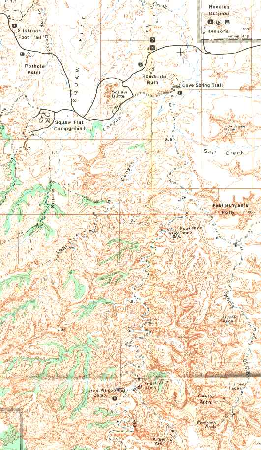
The announcement in the IAC (Idaho Alpine Club) bulletin board and in the WMC (Wasatch Mountain Club) Rambler read: "Backpacking Salt Creek of Canyonlands N.P. (October 6-13, 1999) We have obtained a small group permit to hike Upper Salt Creek in Canyonlands. The plan is to drive to the trailhead the night of October 6th, and begin hiking the 7th. We will hike from the Squaw Flat CG, upstream past pictographs and ruins, exiting the top of Salt Creek by Cathedral Butte. The trip should allow generous time for exploration and contemplation because we will be packing about 35 miles. Contact Rob if you are interested. Space is very limited."
|
Wild Vagabond Main |
Trip Report Index  |
Caveat  |
|---|
Well, it ended up being Brent Laughlin and me. The only drawback was that we had to take two vehicles, because we could not find a shuttle to drop off a car near Cathedral Butte.
|
Day 1: Peek-a-boo to you: (about 6 miles, Squaw Flat CG to Salt Creek at large.)
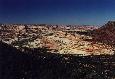
Commentary: "Peek-a-boo to you!" Brent echoed to the propagators far below, camped at what is now the end of vehicle access in Salt Creek. Barriers erected about 2 years ago have closed Upper Salt Creek Canyon to vehicles beyond the Peek-a-boo area, and this larger than ethical, from a worldly point of view, group would have to walk if they wanted to see more of this spectacular canyon carved into 250 million year old Cedar Mesa Sandstone (SS).
After hiking off the pink, dull reds, and white swirled SS nose, we reached a deep crack near the edge of a cliff face. The top of a ladder protruding from it. Brent went down first, disappearing into the dark slot, followed by a report from the unseen depths of "OK, tallyho above, all clear!" After squeezing out the bottom of the crack, we continued to Trail Arch, where we paused to take pictures of the pictos and the arch before proceeding into the sunset.
The Day: It had been a long day of shuttling Brent's car to the Cathedral Butte TH and getting packed for the trail, followed by obtaining the actual permit we had reserved a couple of months ago. We then hiking the highly scenic route from the TH at the CG, undulating through Lost Canyon, etc. to pop out above Peek-a-boo Spring and camp.
The day began with overcast skies and spitting rain. It closed as we searched for a place to camp upstream, South of Peek-a-boo in the fading light. Water trickled down the washed-out ex-jeep road where the nasty tamarisks and other greenery are doing better than usual, flourishing in this wet year. Approximately two years ago, the park service was forced to honor its own environmental analysis about vehicle damage in Salt Creek and the jeep road was closed, rather than bowing to pressure to keep it open from the ORV blue smoke crowd. Some things work out. It's rare and wonderful to see our backcountry expanding.

|
Day 2: Upward Angel: (about 8 miles to old Angel Arch vehicle camp.)
Commentary: "Onward upward angels, marching through the sand, with a frond of willow sticking out my hand." I sang as we thrashed through yet another brushy obstacle.
"Look, there wolf!" said Brent, pointing toward the canyon wall from beneath the stately Cottonwoods at the once vehicle camp near Angel Arch Canyon junction, "petros!" Sure enough, obscure petros decorated the flat flank adjacent to a tiny key hole arch. Looking around, we surveyed this somewhat narrow section of Salt Creek Canyon, with its stratified Neapolitan walls flooded with desert varnish. A grand scene indeed.
The Day: Today, we hiked to near the junction of Angel Arch Canyon, past Peek-a-boo and Bob Arches, around many pools, some formed by past vehicle abuse. Life is growing gangbusters in this corner of the desert. The Cottonwoods, Oakbrush, Single-leaf Ash, and yes, even the terrible Tamarisk are developing their Fall bloom. Our camp is a wide opening among long-celebrated Cottonwoods. It appeared that we would have less impact here than if we were to develop a new camp. Lounging on reclining once-monarch Cottonwood trunks, we sighed, content with the surrounding beauty and with the thought that we are almost to Angel Arch.
|
Day 3: Jungle Jam: (6 miles + 3 day hiking.)
Commentary: Standing beneath the overhang on the low bump above Upper Jump, I was admiring the pictos when I heard the "oh, ahh" from Brent. Turning, I saw a blaze of warm colors, brilliant orange and red trees on the wide bench beyond. We soaked in the vista for awhile, then we returned to searching for an unauthorized camp. Somewhere in the maze of trails and prodigious thrashing through the willows, tamarisk, and flood debris, we had missed SC4 (Salt Creek camp 4). We dropped packs and fanned out, finding a good camp in a wash. Here we could camp where the next rain would remove all signs we had been here. The banks of the was were lined with towering, fluffy cryptobiotics, so we confined all our business to the wash. We tanked up on water at Upper Jump and lugged all our gear and bwana water bags to our bandit camp.
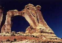
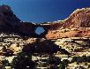
The Day: The day started lazily, with the sun filtering through the hypnotically fluttering green and yellow Cottonwood leaves. We day hiked the 3 mile round trip to Angel Arch, climbing up to touch the buttress of the 120' high, 135' wide, 12' thick span sculpted in 250 million years old Cedar Mesa SS. The sky was nightfall blue, and appeared like a dark high-altitude sky through the polarizing filter on my camera. While walking up the canyon, we saw several ruins and a colored streak picto. It looked like the logo on the train called the Zephyr. At the arch we commented that we had, technically, completed the upward Angel, at least according to one definition. No one said "been there, done that." But I said, "wherever you go there you are." Upward angel and angle is so much more peaceful than full catastrophe living. (Parenthetically, these quips, "wherever you go there you are," and "full catastrophe living," are titles of books on meditation by Jon Kabat-Zinn.)
Thrashing up the main canyon, we crossed and recrossed Salt Creek tens of times, tunneling through the foliage. During one of these stream jumps, my boot spun-out, I splatted in the mud on the far bank, and slowly slid back into the water. Regaining the bank, I came face to mud with what we had been anticipating, the track of Ursus Americanus, a black bear. My instinct was to look around for the bear, but of course he was long gone, probably back up in the Abajos, snacking on the remnants of berries, a thoroughly rotted elk steak, and other delectables. As we continued our jungle jam, we would see many large deposits made by this and perhaps other bears. These were huge mounds of assorted seeds, some piles were as large as a big dinner plate, the kind you use at those 'all you can eat' establishments. As the stock brokers say, during a bear market, make huge deposits.
Day 4: Kneeding Arrival in SC3
Commentary: Brent is lounging on a tarp in the cool sand and I'm reclining on our spacious cooking rock. We're enjoying the shade of the Gamble Oaks in our bandit camp. Sometime before high tea, we will pack the short distance to SC3, our home for the next two evenings. But now, we're content to gaze at the multi-colored rock walls, the cyan sky, and the greenery of Pinyons and Junipers, and the assorted warm browns and yellows of deciduous trees ever so gently waving in a phantom desert breeze. It's so quiet that I can hear the distant tumbling water of Upper Jump.
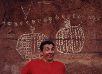
The Day: We began the short venture to SC3 with a thrash in a side canyon to Salt Creek. Brent sprained his knee before we found the exit from this hell hole. I lucked out, because as I was contemplating the maze of brush routes in the ditch, the only hiker of the day came through, from what appeared to be the way we came in, but he reported he was traveling down stream. I reported we were traveling up stream. He and I gazed at each other with disbelief, mulling over the incongruence of each other's reports. So, I got out and directed Brent, who arrived at the bench camouflaged by debris he had gathered in the ditch. At SC3, we lounged in the only and precious shade of an oak, watching the light play on the canyon walls as it filtered through the unnamed 4-faces arch. Later, we walked the short distance upstream to the upper falls and the 4-Faces ruins and pictograph. Decked out with headdress and necklaces, the four faces smile down on us, knowing all but telling nothing about the spiritual history of Salt Creek.
As sunset approaches, we agree that this is a deluxe site at morning and evening, and very poor in between. In the dusky desert stillness, one can hear the rustle of the water splashing over the upper falls. We watch the arch and multi-colored walls, and we can just make out the rock canvas of the pictos near Upper Jump. After a day of rest, we are relieved to learn that Brent can place weight on his knee.

|
Day 5: Arching Through Salt Creek: (9 + mile dayhike).
Commentary: "Yikes!" I stated out loud as I stopped suddenly at the sight of a moderate-sized bear print boldly stamped into the sandy dirt. I had seen signs of this and a smaller bear all during our off-trail arch-hunting adventure, but none so clear as this print. I had discovered, through scatological research and serendipitous snacking of my own, that much of what the bears seemed to be eating was cactus apples (fruits). The apple flesh is succulent, but the seeds defy chewing, and, judging by the prodigious piles of scat, digestion as well. Another problem that I discovered was that the apples are covered by hair-like spines, so tiny they are difficult to see, but very irritating when lodged in the tongue or lip.
I trudged on, toward the elusive Fish Eye Arch somewhere up this curving canyon. I found Fish Eye, Cave, Ridge, and an undocumented arch across the canyon, and ruins situated at dizzying heights around the corner from the All American Man picto. How and how come did the ancient ones build all those structures in such an inaccessible location?? It was a banner day of arch hunting. Along the way, my nose lead me to an old cougar kill, where the puma cat had concealed what was left of a deer by scraping grass and bits of brush together and over the carcass.
Slogging back to camp, I paused at the falls for a refreshing rinse. My feet went from hot, mushy, and bruised to near frostbite in this luxurious desert water. I was pleased to learn that Brent's knee had partially recovered during this day off. Finishing dinner as the red planet headed for the horizon and the evening star popped out and headed skyward, we admired the red glow on the sandstone walls in our backyard.
|
Day 6: Kicking to Kirk: (5 miles on trail, 3 + arch-hunting.)
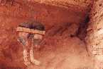
Commentary: Something caught my eye as I was trying to get the right composition for a photo of Kirk Arch. There, inside a large alcove far below the arch was a square dwelling and one that was shaped like a charcoal kiln. They are fashioned from local rock, stuck together with mud. It would require some re-routing, but a visit to these ruins was too tempting to pass up. Along the way, I encountered a handprint where the pigment had been sprayed over some ancient builder's hand, most likely by blowing the pigment through a hollow reed. Amazing. I wound up the drainage, eventually reaching the ruin. One can see the finger prints of our ancient ancestors in the mud-mortar, and sense the connection we all have to this lovely earth and, sometimes, to each other. The feelings and aura are heightened by the solitude and the immense quiet, the faint aroma of peppergrass. A reasonable person has to ask, "what connection does an ATV rider have?" Most likely the connection is to the oil cartel, the Society of Republicans for Respirators, and the American Acoustic Atrocities Association.
On the way back, I bumped into a ruin built on a boulder underneath a pictograph of a bird figure and a long line of triangular banners or shark teeth pictos.
The Day: Today, we hiked from SC3 past a host of arches and some pictos, pausing at the fabled All American Man picto. It's an easy hike except for tunneling through the reeds and brush that in places tower several feet above our heads. Their sharp edges clutch and grab at our clothes and skin, and poke us in all our soft spots. They can punch a cookie-cutter hole in your lip, or something else, if you are not careful.
|
Day 7: Cathedral Climb: (4 miles.)
Commentary: The pocked, striated sandstone walls glow almost imperceptibly as the sun's rays reflect and refract in the sweep of the roving alcove near camp. It's nearly sunrise, and I'm feeling that paisley swirl of happy and sad feelings associated with the end of a delightful desert trip. Standing on a bump above the camp depression, I can sense the slumping cool air that precedes old sol's solar loading. Rolling out of camp, we passed a picto panel near the trail, then we ranged across the springs area, eventually locating the trail, then losing it several times as it wandered through the encroaching brush toward the park boundary. Where the more perceptible climb begins to the rim, the trail improved and we removed our brush pants. We talked about how we had post-holed in knee-deep snow the last time we trudged this steep exit. I thought about how fortunate I am to be graced by the wit and companionship of the stalwart Brent, as we traipsed, agog and accordant, through this agrestal, arciform area.... Today, it was lovely and warm at the trailhead, where we enjoyed a quick water bottle bath before completing the shuttle and settling in for the long drive home, entertained by mental views of the trailhead and inner vista of canyon labyrinth and upward angles and angels.
|
|
|
|
|
|
Wild Vagabond Main |
Trip Report Index |
Caveat |
|---|