Grand Canyon Trip Report / Nankoweap to Kwagunt / Kwagunt to Nankoweap / Nankoweap Creek
(October 16 - 24, 2021 )
Text © copyright by Rob; and Photos © copyright by Rob

|
Nuance of Nankoweap 2021: Stromatolite Stomp /
Grand Canyon Trip Report / Nankoweap to Kwagunt / Kwagunt to Nankoweap / Nankoweap Creek (October 16 - 24, 2021 ) Text © copyright by Rob; and Photos © copyright by Rob |
|
Co-Adventurers: Solo Adventure
Camera: Panasonic ZS-70
Total miles = 60.6 Total ERM = 118
|
| |||||
|
| |||||
|
| |||||
|
| |||||
|
| |||||
|
| |||||

| ||||
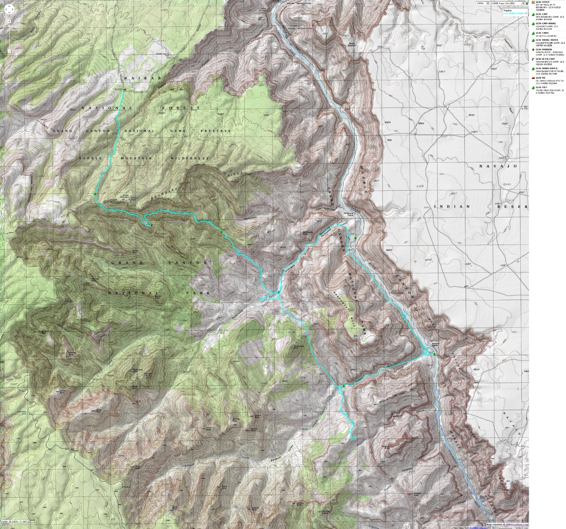
for a full-resolution map, click here. Caution - do not use this map or gps track for
navigating the route.
Grand Canyon Panorama Project - by Larry Wieland, Nankoweap Trail.
You can see the area I hiked by visiting this site. There are many options - click on the spheres to go to a panorama from that point.
There are several panoramas taken from the Nankoweap Trail, for instance. Options also include: Add geology or topo map.
A super series of panos and supporting geology maps. Larry also has panos from along The River. Spectacular!
Grand Canyon Panorama Project - Nankoweap Trail (link here).
Summary: This is a report about a glorious solo jaunt into the Nankoweap-Kwagunt area. I enjoyed
several days of solitude and met some good people too. The country is fantastic and diverse.
"Those who contemplate the beauty
of the earth (Eaarth) find reserves of strength that will endure as
long as life lasts." - Rachel Carson
*ERM = Energy Required Miles.
A mile is added for every 500' elevation gain or loss. ERM was initially used in Trails of
the Tetons (long out of print) by Paul Petzold, founder of NOLS. It's a wonderfully
useful concept and application. Add one mile for each 500' up AND down to distance = ERM.
I use ERMs to calculate what the actual day is like. It's a very serviceable method of
estimating energy required miles.
Estimated mileage and ERM for this trip - 60.6 total trip miles;
total ERM estimated at approx. 118.
My route was to hike down the Nankoweap Trail to Nankoweap Creek from the end
of the House Rock Valley Road (lower Nankoweap trailhead). Then, I lilted over the Nanko-Kwagunt divide between Nankoweap
Mesa and Butte, continuing down to The River at Nankoweap beach on the Colorado. From there, I hiked up River to the
mouth of Nankoweap Creek. After returning to the foot of the Nankoweap Trail, I returned to the trailhead up the Nankoweap
Trail. I enjoyed several days and afternoons of exploration during this jaunt. The Nankoweap requires nuance to increase
enjoyment, don't be jammin The Nankoweap.
The downside of hiking in this area is the horrendous, intrusive, aversive, destabilizing
noise from the air tour terrorists, needless corporate welfare overflights by airplane and helicopter. There are parts of this route
where the noise is so intrusive that one cannot carry on a conversation from a respectful social distance unless you know the
person very well. And this awfulness occurs much of daylight hours in one of the more primitive areas of the Park. Despicable
and outrageous.
Using ERMs does not account for the 'texture' of the route or
trail - that is, rocky, boulders, no trail, slimy mud, etc., yet does help approximate the route.
| ||||
"There are some places so
beautiful they can make a grown man break
down and weep.” - Ed Abbey
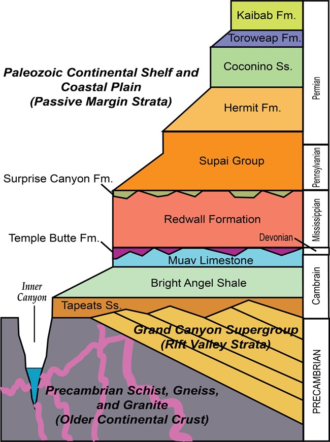
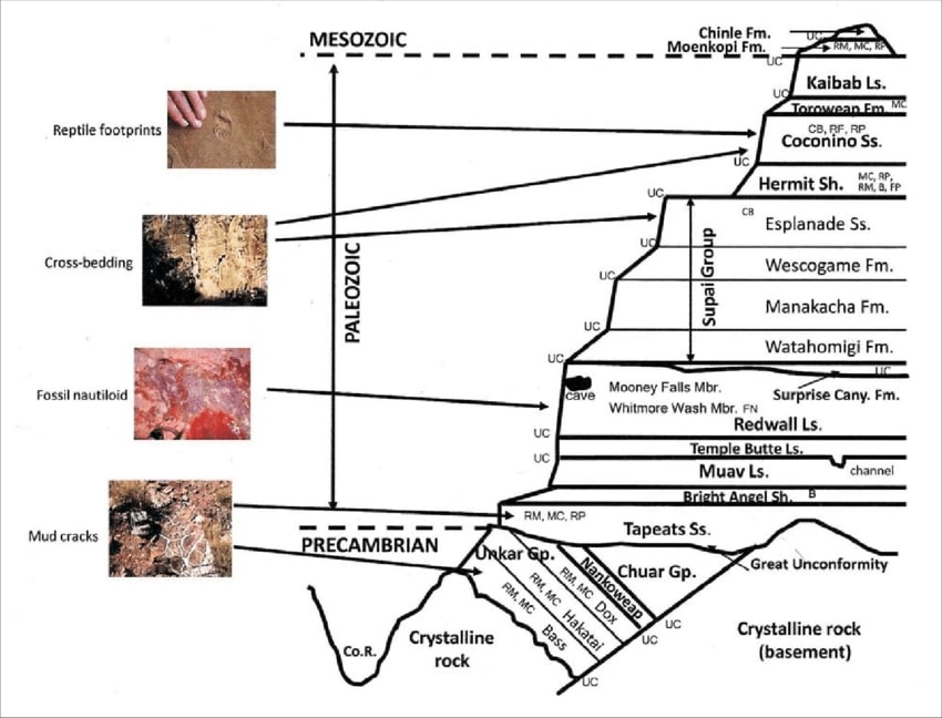
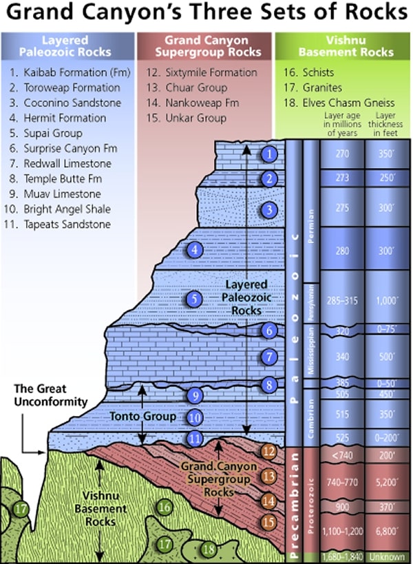
Mnemonic for the basic GC layers - Know The Canyons History,
Study Rocks Made by Time
Know - Kaibab Limestone
Know The Canyon's History, Study Rocks Made By Time.
The - Toroweap Formation
Canyon's - Coconino SS
History - Hermit Shale
Study - Supai Group (including the Esplanade)
Rocks - Redwall Limestone
Made - Mauv Limestone
By - Bright Angel Shale
Time - Tapeats SS
Check the links section for lots more geology stuff. Here are versions of this basic schemata:
| ||||
| ||||
| ||||
Cryptobiotic soil (once called crypto-gamic soil): a crust of cryptobiotic soil provides a
living ground cover in the high deserts of the Southwest. The soil, consisting of cyanobacteria, lichens, and mosses, forms crusts that
are resistant to wind and water erosion and provide nutrients to plant life.
Cryptobiotic soil crusts are an important part of arid and semi-arid ecosystems throughout the
world, including those in Glen Canyon National Recreation Area, Grand Canyon National Park, Canyonlands, etc. Crypto means hidden,
while biota means life. Hence these crusts are composed primarily of very small organisms that cannot be seen with the naked eye.
Well-developed cryptobiotic soil crust is often much darker than the soil it is on top of, and has a sponge-like look and texture. The
extent of crust development depends on soil structure, texture, and chemistry as well as elevation and microclimate.
Cryptobiotic soil crusts are created by living organisms such as algae, cyanobacteria,
and fungi. The bacteria within the soil release a gelatinous material that binds soil particles together in a dense matrix. The
result is a hardened surface layer made up of both living organisms and inorganic soil matter. This crust is an important means
by which arid soils resist erosion by wind and water. Many cryptobiotic soil crusts are able to absorb water more quickly than
regular soils and as a result reduce runoff and also impede evaporation. In addition, the cyanobacteria in the crust, as well as
some of the surface lichens, are nitrogen fixers, meaning that they can chemically convert atmospheric nitrogen into a form
usable by other plants. Lichens and mosses often grow on the stabilized surfaces of the crust, and can often cover the crusts.
Many unusual and unique organisms occur in association with crusts, including many rare and undescribed algal species as well
as rare lichens. It is becoming increasingly clear that the older and better developed crusts support important levels of cryptogamic
plant biodiversity. (from the NPS Grand Canyon and USGS sites)
 |
 |
 |
 |
 |
 |
 |
 |
 |
 |
 |
 |
 |
 |
 |
 |
 |
 |
 |
 |
 |
 |
 |
 |
 |
 |
 |
 |
 |
 |
 |
 |
 |
| ||||
 |
 |
 |
 |
 |
 |
Day 1: Serpentine Syncline. To Tilted Mesa: 8 miles, ERM of 22. Camp @ 6000'.
I knew that I shouldn't have eaten those delightful chillis because my day
started early, and with a trump tower bathroom issue. Good thing that it wasn't a concern or problem. Yikes. So,
I'm on the road to the House Rock Valley (lower) Nankoweap trailhead by 5 a.m. rather than 4. Later, I stop where I
have cell phone coverage and talk with a prospective VIP, Volunteer In Park, about the upcoming volunteer service
project at Bright Angel, at the bottom of The Canyon. And, another toilet tarry and more gas at Marble Canyon before
the 27 miles of dirt/gravel road to the trailhead. For awhile, paralleling the luminous Vermilion Cliffs. Spectacular.
It's a pounding journey at times, and I worry some about sharp limestone
bits puncturing a tire, and this slows the traveling. It's a quiet road except for a glump of Sahara Clubers with grim faces
departing the area in a single dust cloud. Packed together on the road like lemmings. Gee, I wonder how they
enjoyed their trip?
Link to Havasupai Garden Hurrah! VIP service project at Bright Angel and Havasupai Garden
So, it's a later start than I envisioned. Into the Saddle Mountain Wilderness
and up the syncline to the border between forest service and park service at @ 7600' I hike. The starting elevation is
about 6400'. There's a touch of snow on the North-facing aspects of the syncline.
Now, after reaching the saddle and the Park boundary, the long rolling trek
begins in the Supai Formation, the "trail" notched into a slight indentation in the red chocolate wall, the Esplanade.
Recent storms have degraded the trail, producing more ball bearing angled sections and some rock falls. Other sections
have narrowed, although there's not much tread to narrow. Not optimal. And, it seems that the most impacted areas
also sport the most dramatic drops into the abyss. Yikes.
Air tour terrorists ply the saturated blue sky, fouling the air and airwaves. What
a waste of resources such as oil and what horrible destruction of a rare and precious public resource, natural quiet. These
tin can tourists turd fondlers are hardening their arteries while killing the rest of us with their climate-heating petroleum
pollution, raising healthcare costs and shattering the natural quiet. It's great for feeding the greed of corporate welfare.
Other than that, air tour terrorists are a huge, destructive, future-killing force for extinction.
Video about the Air Tour Terrorists. Natural Quiet or Noise Park?
It feels late, and I'm fairly tired upon slogging to Tilted Mesa, at the top of the
gnarly Redwall Limestone. I judge that there's insufficient time to make it to Nankoweap Creek, which isn't far, but
requires slow and careful travel. I select one of the few tiny tent sites just as the trail plunges off Tilted Mesa and
squeeze in my TarpTent.
I can see the last of the sun on the Desert Facade, lit up far beyond Nankoweap
Butte and across The River. Lovely, yet heralding cool temperature, and I soon have on the down coat. Looking to the
West, I'm barely below the snow line on the North facing cliff bands. Burr.
I brought a big sandwich rather than cook tonight, in the event I didn't make it
to Nankoweap Creek. This is yummy and just right, followed by a quick retreat into the fluffy bag.
The nearly full moon glows through the tent wall, but it doesn't affect my most
excellent dreams.
| ||||
 |
 |
 |
 |
 |
 |
Day 2: Nankoweap Oasis. To Nankoweap Creek +
explore Nankoweap Canyon:
7 miles, ERM of 13. Camp @ 3350'.
Eaarthly quiet is the surround sound as the golden orb joins me on
Tilted Mesa. It's crispy cool and warming rapidly as I set up the LightSaver solar collector and then break the
fast under the watchful spire of Mt Hayden.
Not much water remains in my containers, perhaps just the right
amount to get me to the oasis of Nankoweap Creek. Hurrah!
"Water, water, water . . . There is no
shortage of water in the desert but exactly the right amount, a perfect ratio of water to rock. Of water to sand,
insuring that wide, free, open, generous spacing among plants and animals, homes and towns and cities, which makes
the arid West so different from any other part of the nation. There is no lack of water here, unless you try to establish
a city where no city should be." — Edward Abbey, Wilderness Reader
It's a hardscrabble drop to this oasis, one that would be just right for those
unethical, unyielding, charging trail runners. At least those who have excellent health insurance. Note that I'm saying
"insurance" and not "healthcare," because this is the reality when corporate welfare artists are the middleman between
you and your health. It's the (wrong) American way. The running group might describe this drop as "grit in your teeth," or
"cheese grater fling," or perhaps the "GC ambulance amble."
Link to a report about backpacking the Butte Fault Route
I gather good, clear water and start treating it with the reliable Aquamira while I
throw the basics of camp into place, after which I explore the artifact strewn glory of Nankoweap. While scanning for
Indigenous artwork, I lose situational awareness and perform cactus acupuncture. Ouch.
I'm well down the slippery cheese grater slope through the Redwall Limestone
when the conveyor belt of turd fondlers arrive in their climate assaulting, fat enhancing, high decibel pollution
machines, wreaking havoc to natural quiet and visual splendor. Air tour terrorists. The same tin can experience can
be had in an imax theater, pumped full of aviation fuel fumes and seats rigged with air bags to add an air sickness element.
This horrid carnage will continue throughout this Nankoweap-Kwagunt adventure. You, dear reader, are sick of hearing
about the air tour terrorists, but not nearly as much as I am sick of hearing and seeing these miserable AHs. Enough.
The trail, such that it is, narrows to boot width at times before transitioning to the
long lateral on the Bright Angel Shale. A Raven wings nearby at eye level, wings rasping noisily, and she winks at me,
apparently wondering if I might be lunch soon. Opportunistic avian omnivore.
As the trickling song of clear water drifts up to the bench I'm walking to Nankoweap
Creek, I also hear voices down below. It's Stephen Coldren and Chris McCoy, walking the length of the Grand Canyon, and I
get to the creek in time for a brief discussion before they move on to Kwagunt, Malgosa, Lava, eventually Clear Creek and
Bright Angel for their next resupply. See the photo of Stephen and Chris in the above photo set.
This is the Butte Fault Route section. They started at Lee's Ferry. An amazing walk. Safe
travels young men.
While dinner hot soaks, I enjoy a bucket bath to remove a pound of salt and dirt.
Ahh. I nearly miss seeing the cotton ball clouds turning yellow to the North, followed by a dapple of clouds turning from
salmon to crimson to the West. Yowee. Surround vistas.
Dinner is enjoyed in the dark with the background burble of the oasis, Nankoweap Creek.
| ||||
 |
 |
 |
 |
 |
 |
Day 3: Klimbing to Kwagunt, the Stromatolite Stomp. To
Kwagunt Creek: 4.5 miles, ERM of 9. Camp @ 3390'.
Inching up the very steep route to the break in the dark reef, more of the
Nankoweap drainage comes into view behind me, when I feel stable enough to partake of the view that is. There's
the fork to the cul-de-sac near Marion Point, a branch to a spring and leading to the Marion-Seiber Route, the main
drainage headed toward Kolb Natural Bridge, and more branching off the branching. No wonder Nankoweap floods
so dramatically, it's drainage is huge. Climbing through the gap in the reef, I pause to look for Stromatolites that I may
have seen last time, not knowing what they are. I photograph some mediocre specimens, then continue to the
moon walk on a treacherous angle of dark reef. I move across it carefully, then walk the mostly level softer gap
between layers of dramatically faulted reef. Eventually angling through the pulverized bluish shale, I arrive at the saddle
between Nankoweap and Kwagunt. Horaah.
Now the hiking is sharply down, in and out of the wash, avoiding pour-offs.
At first, the colorful shale provides excellent walking. Soon, it's a dramatic descent into a sometimes clogged wash.
Along the way, Stromatolite boulders appear. Now that I know more about what they look like, they seem to be
everywhere. They appear to be bedrock at times.
The gusting wind turns into a gale, making it difficult to retain my leashed
hat and knocking me off balance on some boulder work. It must be 30 MPH, and feels like more.
When the drainage parallels a dark plate of reef, soaring a hundred feet out
of the drainage at 75°, I know that soon I'll arrive at the final pour-off before meeting the luscious, yet this year
feeble water of Kwagunt. Yahoo.
Now the gale has ushered in a dark mass of cumulus clouds, streaming in
rapidly from the South. Yikes, this is ominous.
I locate the camp I previously used, the one I call "Rats' swim team" camp
because mice jumped into my water bucket each night, although apparently they couldn't swim. It's the same camp
that Gary S told me about, although it sounded like different camps when he was describing the area.
I gathered some water and set up in the nook between a spreading Juniper
and a clog of Mesquite, which is mostly protected from the gathering gale. The clouds turn purple and waves of rain
arrive along with a fifteen degree temperature drop, driving me into the just established tent.
It's not a lot of rain, but enough to want to avoid being out in it. At sunset,
it dribbles on, backed by the swirling wind. I know that the land desperately needs the moisture, but ick.
Stromatolites (from the GC NPS website): The oldest fossils at Grand Canyon are 1,200 million to 740 million years old. Stromatolites are the limestone structures formed by photosynthesizing bacteria called cyanobacteria. They created layers of alternating slimy bacteria and sediment in very shallow water, dominating shallow seas until predators, such as trilobites, came into the picture. Today stromatolites only live in a few shallow ocean areas with high salinity. The salinity deters predation and allows the stromatolites to survive.
 |
 |
 |
 |
 |
 |
Day 4: Suppa Duppa. Explore Kwagunt:
6 miles, ERM of 11. Camp @ 3390'.
The beginning blush of Cottonwood Fall gold in The Canyon frames
Hutton and Duppa Buttes. Supper. Supper Duppa. I'm near the spring of Kwagunt Creek, lounging in the deep
shade of a sandstone boulder and enjoyed second lunch. Lunch #1 was in a broken plate shade of one of today's
reef experiences. Yes, it's been a day of reef wrangling and gravel crunching in the exploration of Kwagunt Creek.
A day of unhurried searching for shards of sherds under a startling azure sky. There's no hint of yesterday's gale or
angry clouds. Yippee. And, it's a solitary day of solitude. The last hikers I saw were the TransCanyon hikers, Stephen
and Chris, two days ago.
The day started cold, with the arrival of the sun greatly delayed; the perception
of this accentuated by my cold fingers. Every tap-tap-tap of the woodpecker in the Juniper tree seemingly in slow motion.
I decided to hike up the West bench rather than wait below. Good idea because I quickly thaw and turn my attention to
shards of sherds.
It's pleasantly warm when I return to camp, just right for a bucket bath and light
laundry.
It seems way too early when Kwagunt drainage plunges into shadow and the
long and cooling night soon follows.
I lounge against my pack in the cook nook and watch the first of billions and
billions of stars appear, later to be blotted out by the glaring moon.
| ||||
 |
 |
 |
 |
 |
 |
Day 5: Kwagunt Kloisture. To The River:
3.5 + 2.5 = 6 miles, ERM of 8. Camp @ 2800'.
The tinkling trickle of water reflects the gold hue of Redwall. Kwagunt music.
Picture perfect. Bobcat tracts precede me down this music venue, showing the way around minor boulder jams, pussy
cat footprints are embedded in the rich red silt. Cat pilot. (The photo in the above photo set is not of the cat track, note the
toenails and the canine cross.)
And then the music stops. Kwagunt Creek goes subterranean, disappearing
below the silky Muav walkways and rounded rock and gravel beds. Water music is replaced by the whisper of boot on
sand and dried mud, the clatter of clamoring over rolly rocks. The Canyon retains its awe and character, yet without the
water music.
I'm not in a hurry and pause where the canyon aligns with the sun, set out the
LightSaver solar panel and meld with rocks made by time. Second breakfast.
As the canyon begins to open, and I can see most of the wall on the opposite side
of The River, the deep thunderous thumping reverberations of The River are felt. Yes, it seems to start as a combination of
bone conduction vibration and sound. Rhythmic. Chakra sensation. (Chakras are the concentrated energy centers of the body.)
Nope, Kwagunt Creek doesn't reappear, yet The River water is clear. Leaving the
coolness of the side canyon walls, the direct sun is quite hot, so I start treating some water and savor lunch #1 and #2 in the
shade of a mesquite. High clouds temper the solar cooker, so I scout for the faint route above The River to Nankoweap, finding it
just at the edge of the Kwagunt opening and just above the low bench of tamarisk and mesquite. It appears to have not been
used in quite awhile and that the traffic has been thin.
Camp is just up River from the Kwagunt beach, which is lightly populated by a group
of private boaters.
The sun line moves up the towering Desert Facade, signaling falling temperatures and,
gloriously, dinner time. In a few minutes it's time for three shirts. Thoughts of the upstream fading sewage pond of Lake Fowl
arise as the deep resonance of The River fills the Canyon void.
Grand Canyon Panorama Project:
Inner gorge at Kwagunt, Nankoweap, etc (link here).
"Men may dam it and say that they have
made a lake, but it will still be a river. It will keep its nature and bide its time, like a caged
animal alert for the slightest opening. In time, it will have its way; the dam, like the ancient cliffs, will be carried away
piecemeal in the currents." — Wendell Berry
Tamarisk, (Tamarix spp.) commonly known as salt cedar: is an exotic (non-native)
shrub or tree that grows in dense stands along rivers and streams in the West. Tamarisk, introduced to the U.S. in the 19th century
as an erosion control agent, spread through the West and caused major changes to natural environments. Tamarisk reached the
Grand Canyon area during the late 1920s and early 1930s, becoming a dominant riparian zone species along the Colorado River
in 1963 (following completion of Glen Canyon Dam).
The impacts caused by tamarisk in the Southwest are well documented. These prolific
non-native shrubs displace native vegetation and animals, alter soil salinity, and increase fire frequency. Salt cedar is an
aggressive competitor, often developing monoculture stands and lowering water tables, which can negatively affect wildlife
and native vegetative communities. In many areas, it occupies previously open spaces and is adapted to a wide range of
environmental conditions. Once established in an area, it typically spreads and persists. (from the NPS Grand Canyon page)
| ||||
 |
 |
 |
Day 6: A Decent Beating. To Nankoweap along The River:
4.6 miles, ERM of 9. Camp @ 2890'.
There are probably a hundred or more tiny drainages keep up the heart rate,
straining the leg muscles along the very faint route above The River between Kwagunt and Nankoweap. The route looks
flattish on the topo map (no, it's not shown on the map), yet doesn't depict the endless 20', 15', 50 ' swales of this
connector. Shale slopes produce high angle humps with less than a boot width of tread. Each rainstorm eliminates
whatever path might have been. Limestone-studded rip rap on side hills where a trail doesn't stick adds to the fun.
Duplicate routes through sandy sections. It's not a long jaunt, yet it's complicated by the terrain. It's more tedious
than difficult.
Finally, there's a flourish of rafter paths, leading to a camp, to the climb to the
granaries, to now tiny Nankoweap Creek. Hurahh.
I find a prospective camp, which will have to await local sunset, plop the pack in
the limited shade, align the solar panel with the drift of the sun, and go exploring even though I'm quite tired and
although today was fairly hot.
There are old and ransacked Pueblos overlooking The River, all artifacts long
ago vacuumed away. Social trails everywhere, most leading nowhere interesting.
About 4 p.m., it's local sunset behind the big walls and I return to see if any rafters
have arrived. There's a group at the best camp downriver, and no one here, so I treat more water and "enjoy," hah, a
River bath. "Can anyone "enjoy" a bath in 50 degree water?" I muse. By now it seems reasonable that people are off the
River, so I finish establishing camp.
I'm just into dinner, and it's past official sunset when the rafting group arrives.
No issues, concerns, or problems with sharing on my part, and I tell them this but they use the upper portion of the beach
anyway. They are less than friendly. One might say that they exhibit "Oars behavior." Briefly, they are "trump boaters."
Gee, I feel puzzled by the mercurial nature of interactions with boaters.
What is it? Is it me? I make a point of exhibiting prosocial skills and don't ask for anything. Many seem highly avoidant
to interacting, as if I might club them with my hiking poles and steal their boats and beer. Geeze. There are the extremes,
of course, from the generous and friendly welcoming hospitality of groups like the Otter party (see the just previous
Escalanté report) and AZRA groups, to the unbelievable harshness and entitlement displayed by the Oars group at South
Canyon (demanding we leave, although we were set up and over 200' from the beach) and at 75 mile where Oars refused
to share the outskirts of the camp zone. Perhaps it would be helpful for boaters to display flags, like pirates. "Come
near at your own peril," - a trump flag would work to signal malignant narcissists or a similar highly aversive personality,
or they might display a peace sign flag to indicate "we're sociable and love to talk Canyon." Of course hikers can be just
as inhospitable, yes indeed. I'm wondering if antisocial behavior is more common in large groups? Certainly, the probabilities
suggest a higher propensity for mental instability when dealing with large numbers. Trail runners in The Canyon, for example.
Do the interactions within a large group actually produce antisocial and self-centered behavior? Elicit underlying pathology?
I suppose that it's one
reason I favor small groups. I seep back into Canyon time, leaving the trumpers to enjoy their own space. "A group of
one is just right" I muse, continuing "the discussion is lively and there's little antagonism."
It's dead dark as I write these notes and early stars are popping in the narrow slice of sky above upper
Nankoweap beach. The bats are active, and I'm becoming less so.
I choose to listen to the river for a while,
thinking river thoughts, before joining the night and the stars." — Edward Abbey
| ||||
 |
 |
 |
Day 7: Return to Nankoweap Creek Camp. To near the foot
of the Nankoweap Trail:
5 + 2 = 7 miles, ERM of 11. Camp @ 3350'.
The sun glare from down River prevents capturing a prize winning
photograph, yet it's a spectacular vista all the same. I've made the mandatory pilgrimage climb up to the Nankoweap
granaries and I'm pleased to see that the trump boaters are still fiddling with their Spanish Armada amount of gear
at their still dark beach enclave. The good news is that they aren't here.
It's a restful, magical place, and a place of meditational bliss. Lovely. Perhaps
a thousand years ago, Pueblo people lugged water up the hundreds of feet from The River to mortise together
locally sourced stone, producing a safe storage from rats of all sorts, including, they hoped, two-legged rats. These
granaries represent extraordinary efforts to protect the harvest. And, what a view! The word "terrific" is overused,
especially on the farcebook (AKA false bravado), yet this view is beyond terrific. It was on the face of the Park Pass
one year. I lounge luxurious in the now heating toward hot sun and live the moment of this special place.
Back down and near burbling Nankoweap Creek, I encounter two doe deer.
They peek at me through a veil of mesquite, reluctant to come out into the heating sunshine.
Deciding that it's time for second breakfast, I join the deer under a streamside
mesquite, with complementary orchestras of thunderous percussion from The River and the gentle burbling ballad
from Nankoweap Creek. Delightful.
It's obvious from the seemingly new windrows of cobblestones and boulders
that Nankoweap Creek has fairly recently experienced a flash flood.
It's a delightful journey up the creek, punctuated by Cottonwood trees just
donning their Fall apparel. Gold against the ebony of basement rocks is a good look.
Even with all the poking along, I arrive at the camp location at just the right
time for first lunch. A glorious stillness and solitude envelop the area, air tour terrorists permitting, and it's an
excellent opportunity for a full laundry and a proper bucket bath. Second lunch finds me lounging sans clothing,
relishing the perfect ambiance of warm sun, still air, tremendous scenery, and no bugs. Yahoo. The flies will arrive
later.
As local sunset creeps in, the laundry is dry, the solar panel with a bit of
charge, the hiker with clean skin, and Tilted Mesa reflecting a desert sunset. Superb.
| ||||
 |
 |
 |
 |
 |
 |
Day 8: Explore Mystic Falls arm: 6 miles, ERM of 9.
The shrieking wind wakes me. It's been an uncomfortably noisy night.
Clouds encroach, trapping the heat. More unpleasantness. I get up to attach more guys to the tent and to gather
everything into the vestibules in case of rain.
There's a brief pause in the wind at morning. So, I'm out to explore for
shards of sherds in the Mystic Falls arm of Nankoweap. Sherds are bits of broken pottery, while shards are bits of
broken glass, ice, etc.
First, I wander up the drainage leading toward Nankoweap Butte, where I
see a tilted pavement of pavers laid out like an ancient Roman road. "What is this?" I muse. Later, I learn from geology
professor Laura Jones Crossey that it's the Yellow Brick Road.
And yes, as I understand it, this is the Northern
end of the Butte Fault, wilderness highway to Clear Creek and Phantom Ranch. It's an epic journey.
"This is a bedding plane
exposure of the Chuar Group within the Grand Canyon
Supergroup. The alternating brittle carbonate layers and shale result in these dramatic joints. We like to call it the
"Yellow Brick Road," as some of the layers have a very yellow/gold color! In some portions of the angle of the beds
is very steep, since these layers are folded up against the Butte Fault." — Dr. Laura Jones Crossey, private
communication
The spring is running well about a mile up the branch off the main
Nankoweap Creek. Otherwise, there's little interesting to report. Except reporting the wind. Horrible. I'm happy
that it's not combined with rain. Ick. On a previous trip, some surface foundations and sherdery were seen and
enjoyed, but not today.
I'm contemplating hiking to the Subie Subaru tomorrow because either
the Tilted Mesa or the Marion Point poor camps are really terrible in bad weather, particularly wind. What
a grunt. We'll see.
Bats arrive briefly, yet seem to be blown away. I hope that
they're okay and get enough to eat.
Purple and red bulbous, yet not mammatus, clouds close the
day. The wind is still gusting. Sigh.
| ||||
 |
 |
 |
 |
 |
 |
Day 9: Trance or Fugue State? Psychogenic Fugue Dissociation
Deluxe. To House Rock Valley TH: 11.5 miles, ERM of 26. Camp @ 6,000'.
Again with the wind, making it difficult to sleep. Argh. So, since I'm not
sleeping, I get up, as planned, at 4 a.m. and employ the morning routine, including gazing at satellites seen zipping
through the holes in the cloud banks, themselves flying along on robust high altitude winds.
I wrestle with deciding how much water to tote up the precipitous gradient
to the saddle. What if I decide to camp at Tilted Mesa or near Marion Point, or even at the saddle? I really don't
want to camp in any of these locations because of the wind at the first two and the wind and the cold at the latter.
So, I start as soon as the daylight is decent, puffing part way up the limestone
layer before the sun hits me. My first long break is on Tilted Mesa, enjoying a few precious minutes before the turd
fondler conveyor belt of air tour terrorists erases all ability to hear anything. Noise Park. It must be 9 a.m. A liter of
mango green tea complements several snacks. Second breakfast. Then, up into the Supai Formation and on the rolling
contour (much up and down imbedded in this contour) to Marion Point for snack and footbreak #2. Third breakfast.
The Canyon slips away. Another liter of water. More snacks. I evaluate my progress and the time, then check the deep
chakra of my septuagenarian bulk. I do this by holding up my leg while sprawled sitting on the ground against my pack
and see if I can hold it up for more than a few seconds. "Humm" I discuss with myself, "the empirical question of deep
chakra capability is a partial fail. Then again, perhaps I'm fooling myself with the "partial" part?" Onward. It's a good
thing I have two trekking poles because I notice some weaving and lurching as I head for the short climb to the saddle.
More snacks, another liter of water, much gazing at the Butte Fault Route, which eventually reaches Clear Creek and
from there Bright Angel Creek. Gorgeous. Lunch. But quick. There's too much wind and the wind chill prompts me
to head downhill, toward the Saddle Mountain Trailhead.
Somewhere along the way, I enter a zen or trance or fugue state. "It's
probably just your poor training of being able to switch from the body burning simple sugars to fat, and you
have lots of fat so too bad, now you have to tough it out or sleep in a ditch somewhere, also, you didn't get
much sleep," I conclude. "Did I just say that out loud?" I ask. "Does it matter?" is my reply. "Not that many
miles, yet a gob smack of ERMs," I chant. "Is this a brand of Stephen Covey's motivational mantra?" I wonder.
After all he said "Between stimulus and response, there is a space where we choose our response." "Duh," I
muse, "prodigious verbiage, an utterance of insignificant consequence used by PR (post rectal) marketing
malevolent malcontents," I huff. "A behaviorist would be insulted hearing this inept mockery of functional
analysis of behavior," I quip. "I choose to get out of this wind tonight," I muter, realizing that it's the fugue
state talking. "Or is it? Some people say a lot but have little to say," is my riposte. "You're blubbering
incoherently, using circular reasoning and your initial premise is without a verifiable foundation; and
also, what you're saying is word salad," I retort.
"The Nankoweap requires nuance to increase enjoyment, don't be jammin The Nankoweap," I remind
my own self.
Pause for recentering. Long distance looks into Marble Canyon
grace the East, dappled fading sunlight on the tawny landscape. The contortion that is a syncline over to the
West. Huge monarch Junipers beside the unburned portion of trail. Trailhead! I stretch a bit, fire up the
Subie Subaru, and ease on down the road to a flat area protected by a copse of Juniper before eating a
quick dinner and spreading out my bag and pad in the car to sleep. The wind rocks the Subie, rocking
me to sleep, restoring the nuance to Nankoweap.
"I would rather sit on a pumpkin,
and have it all to myself, than to be crowded on a velvet cushion." — Henry David Thoreau
|
| |||||
 |
 |
 |
*ERM: Energy Required Miles, are there data to support this
mileage adjustment?
Journal of Outdoor Recreation, Education and Leadership
Petzoldt first proposed his theory in his 1976 book “Teton Trails” to
help backpackers plan trips and calculate their energy needs on mountain trails. “Petzoldt defined one
energy mile as the energy required to walk one mile on the flat. He recommended adding two energy miles
for every 1,000 feet of elevation gain, so a person hiking one mile and 1,000 feet upward would use the
equivalent of three energy miles,” Phipps said.
Petzoldt’s energy mile theory was just a reflection of the mountaineer’s
“gut feeling,” Phipps said. The theory had never been tested in a laboratory before the study began in WCU’s
Exercise Physiology Laboratory in the spring of 2010, Phipps said.
To determine the validity of the theory, the study measured the energy cost
and perceived exertion for walking on flat ground, with and without a 44.5-pound backpack, and up an elevation
gain of 1,000 feet, with and without the backpack, through the collection of metabolic data, Phipps said.
Twenty-four student, faculty and staff volunteers, including 12 males and 12
females, went through four testing sessions as the research continued into fall semester of 2010. The study
results showed that the additional energy cost for ascending 1,000 feet ranged from 1.34 to 2.02 energy mile
equivalents, for an average of about 1.6 miles, compared to Petzoldt’s use of two energy miles for each 1,000
feet. The range revealed by the study was due to the “hikers” personal weight differences, Phipps said.
“It is remarkable that Petzoldt’s energy mile theory is so close to the actual energy cost measured during our
study,” Phipps said. “In the field of outdoor education, it’s important for leaders to include an estimation
of energy requirements during the planning of hiking trips.”
Phipps said the energy required for hiking up steep mountain trails would vary
for individuals and groups, and the variables of the trail would also factor in, but he recommends that
backpackers stick with Petzoldt’s idea of adding two energy miles for every 1,000 feet of elevation gain when
planning trips.
The Validity of Petzoldt's Energy Mile Theory, 2010
Authors: Maridy McNeff Troy, Maurice L. Phipps
Publication: Journal of Outdoor Recreation, Education, and Leadership
.
Sites:
Grand Canyon Panorama Project - Nankoweap Trail (link here)
Canyon Tree Frog (hear them here, mp3, 112kb)
the geology of the Grand Canyon by Canyon Dave
Click here to enjoy the first Nanko report:
Gnarly Nankoweap (2008)
here is the 2010 Nankoweap report - Chocolate Nougat Nankoweap (2010)
Link to a report about backpacking the Butte Fault Route
Link to Havasupai Garden Hurrah!
VIP service project at Bright Angel and Havasupai Garden
7 billion and counting - will anyone
survive?
World population clock - watch the number spin, geometrically,
and be frightened, very frightened.
Arithmetic, population, and energy - the geometric
function (youtube mini-lecture on math)
Other WV reports about the Grand Canyon:
Click here or on the Looking Lizard to go to all WV reports about The Grand Canyon
| ||||
Maps:
| ||||
for a full-resolution map, click here. Caution - do not use this map or gps track for navigating the route.
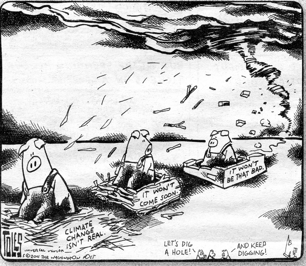
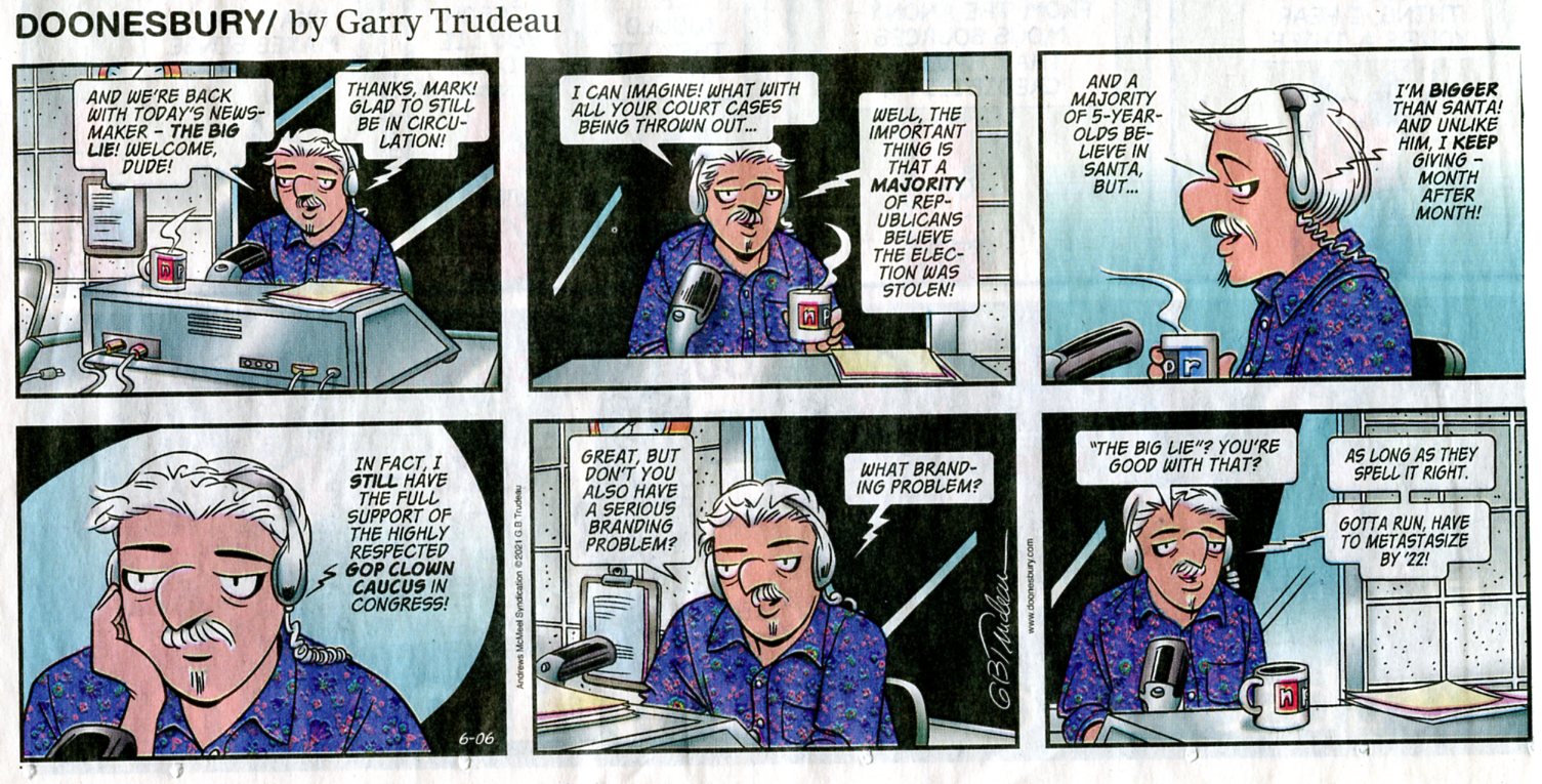
More Truth than Joke:
| ||||
| ||||
| ||||
| ||||
| ||||
| ||||
| ||||
| ||||
| ||||
| ||||
| ||||
|
Wild Vagabond Main |
Trip Report Index  |
Caveat  |
|---|


