Roving The Happy Horsethief and Bodacious Butte Fault:
Backpacking the Butte Fault Route / Nankoweap to Bright Angel / Horsethief Trail / Nankoweap / Kwagunt /
Malgosa / Awatubi / 60-mile / Carbon / Lava / Unkar / Vishnu/ Clear Creek
April 15 - 25, 2013
Text
© copyright by Rob Jones and Photos © copyright by Rob
|
 |
|
|---|
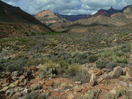
Nankoweap - ruin in foreground - Day 2
(Click the image for the full-size image)
|
|---|
|
|
|---|
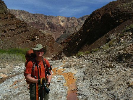
Bill in lower Lava Canyon - Day 4
(Click the image for the full-size image)
|
|---|
|
|
|---|
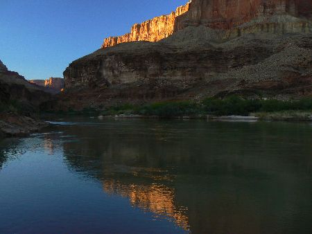
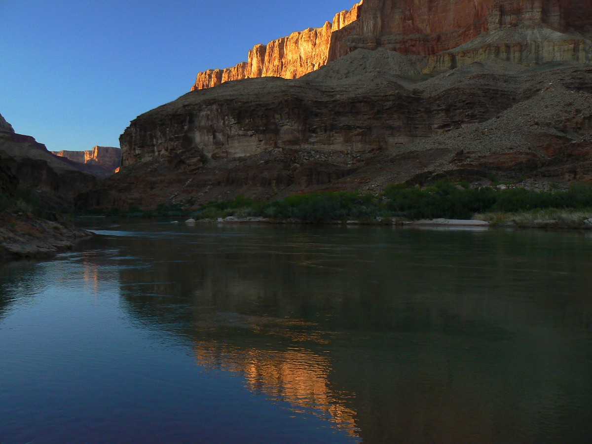
Colorado River from Lava Beach - Day 4
(Click the image for the full-size image)
|
|---|
|

|
|---|
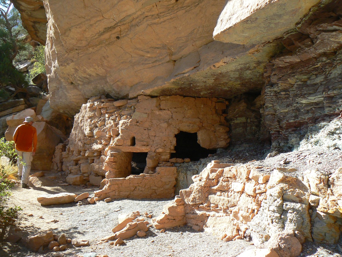
Chris at Juno Ruin - Day 5
(Click the image for the full-size image)
|
|---|
|

|
|---|
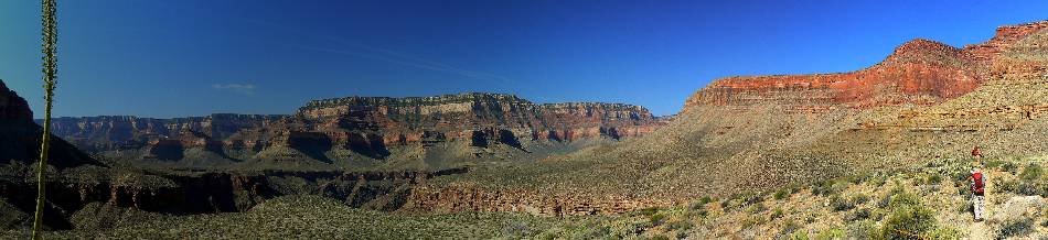
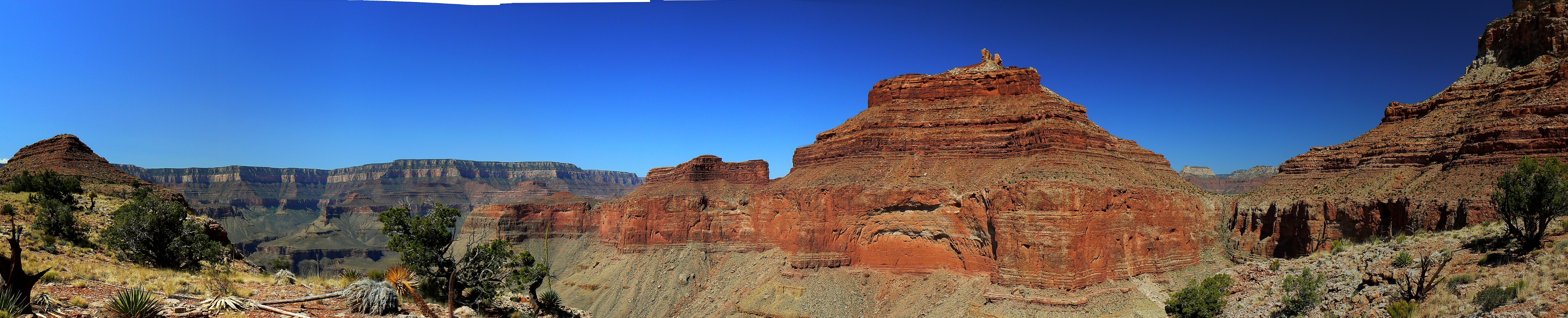
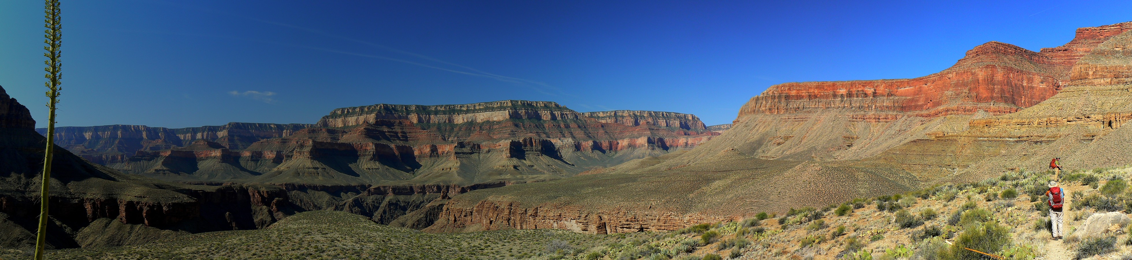
pano day 8 - Hall butte to Angels Gate to Whoton Throne - scroll L-R to view it
all (4222 x 900 pixels, 1.5mb)
(Click the image for the full-size image)
|
|---|
|
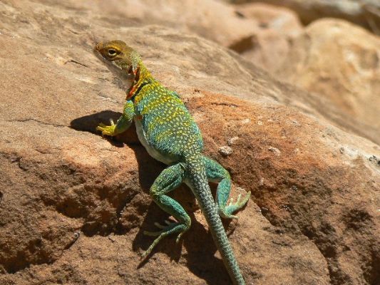
(There are - photos embedded in the trip narrative.)
Co-Adventurers: Bill Ferris and part with Chris Forsyth. Thanks to Dennis Foster for the shuttle.
Bill's report about the Bodacious Butte Fault epic: Bill has previously hiked
and written about this route. He has also posted a very detailed report about the current trip.
You can find Bill's report and superb photos here (click here)
Bodacious Blatant, remarkable, audacious, impressive, or attractive.
As you can tell from the wide-spectrum definition, this
American word is one of those wide-ranging superlatives to which speakers turn when they want to
say that some quality is present in large degree; that quality might be unreasonableness, impressiveness,
insolence, or (most recently) female attraction, specifically big breasts. This last meaning seems to have
become widely known in the middle 1980s after it was employed in the film An Officer and a Gentleman in 1982.
Another film, Bill and Ted’s Excellent Adventure of 1989, contributed to its growing nationwide popularity.
As a result, many people would guess the word is modern, but the
earliest record (actually of the adverb bodaciously, which appeared as body-aciously) is from as long ago
as 1832. The adjective is known from the 1840s, often as bowdacious in the early years. This leads
lexicographers to think that both it and the adverb are from a English West Country dialect form,
written as boldacious or bowldacious, which was probably an amalgam of bold and audacious.
ERM - Energy Required Miles. A mile is added for every 500' elevation gain or loss.
It's a very serviceable method of estimating energy required miles.
Yet, ERMs do not account for the texture of the topography. This route is tough going,
there is no trail between Nankoweap Creek and the Clear Creek Trail, none.
Total trip - (per my GPS) of 78 miles and total ERM = 163, indicating an immense amount of elevation
gained and lost.


|
|---|
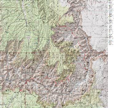
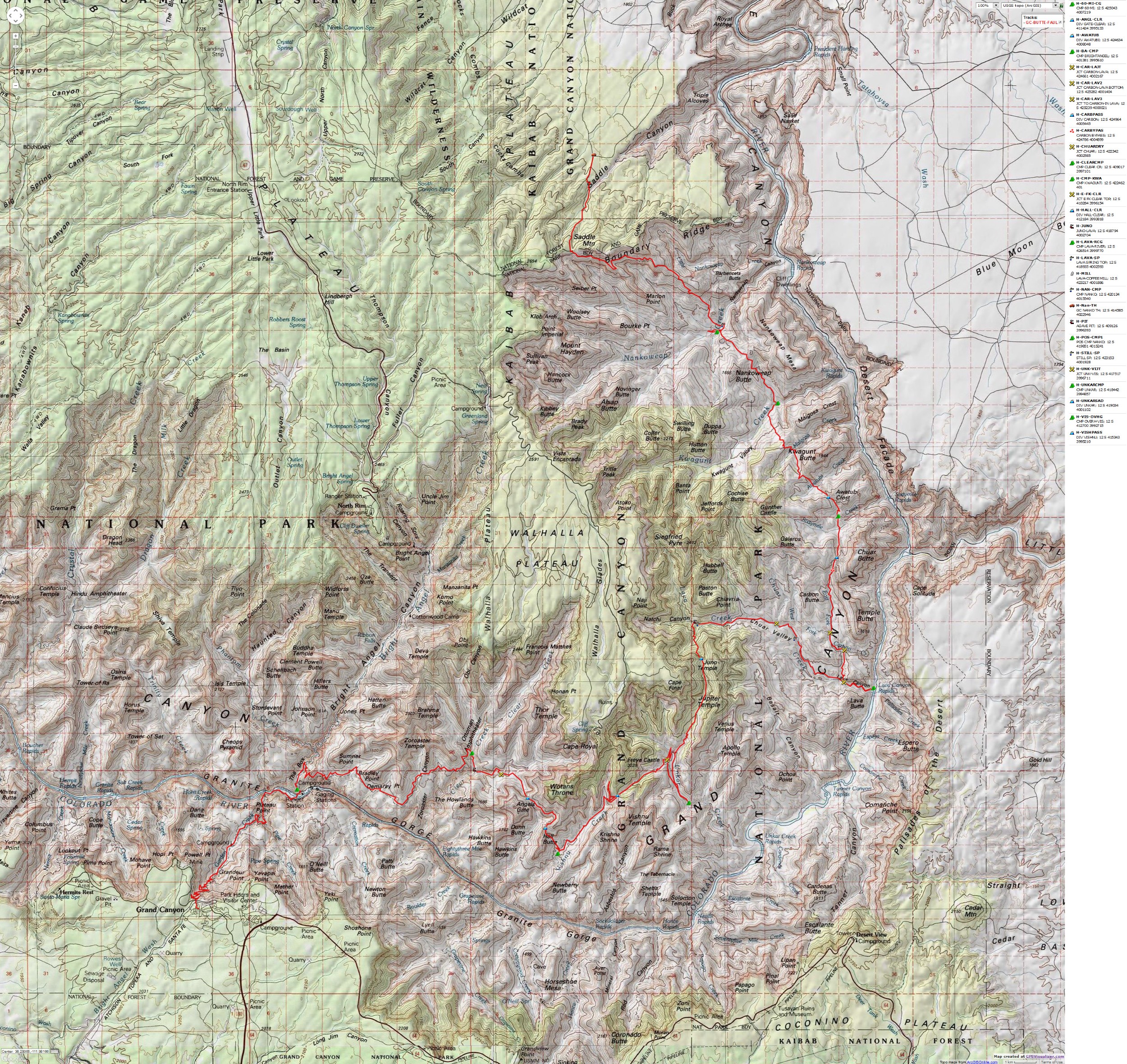
Map - Grand Canyon: Mankoweap to Bright Angel; 2013; 78 miles
(Click the image to see the map)
|
|---|
|
for a full-resolution map, click here. Caution - do not use this map or gps track for
navigating the route.
Click here to go to Bill Ferris' day-by-day and overview maps of our route. Bill used my GPS track and his mapping
skills to construct these maps. An internal link references Bill's excellent report and his GC Adventure site.
Caution - do not use these maps or gps track for navigating the
Butte Fault Route. It can be a tricky place.
“The good thing about science is that it's true whether or not you believe in it.” - Neil deGrasse Tyson
Summary: Three of us hiked from Nankoweap to Bright Angel (South Rim
via BA Trail). There is trail only at the start and end of this route. Be prepared for slow going, this is a more difficult
route in the Grand Canyon.
Nankoweap to BA to South Rim: Roving the Happy Horsethief and
Bodacious Butte Fault Route (10 days)
With camps at: Nankoweap, Kwagunt, 60-Mile, Lava (2), Unkar, Vishnu,
Clear Creek, BA.
Mini History - Walcott and the Nankoweap Trail: Dennis Foster
has written about The Walcott Expedition, Deciphering the Grand Canyon Expedition of 1882-1883. Here's a link to
his publication.
The Walcott Expedition, by Dennis Foster (click here)
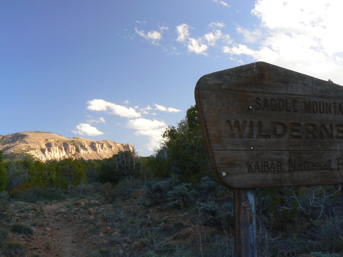
Prelim: Haboob to Nanko TH: Shuttle.
The dust cloud swirls and obscures much of Hwy 89 as Dennis Foster drives
Bill and me toward Bitter Springs and a rendezvous with a sandwich under the towering Vermilion Cliffs.
Haboob. 60+ MPH gusts spreading garbage from poorly-covered transfer trucks across the Big Rez.
On to Lower House Rock Valley Rd (8910) and a chilly and windy evening
observing Saddle Mountain. Dust coats the inside and outside of the tent. It feels good to snuggle
into the fluffy bag.
Haboob = a type of intense dust storm carried on an atmospheric gravity
current. Those sardine can citizens of Phoenix know about the Haboob.
Day 1: Windfall: To Nankoweap Creek.
10.5 miles; ERM = 27. Camp @ 3400'.
The graupel drums off our hats and rain jackets, propelled by shrieking
winds from the SW. It's cloudy, cool, and time to hike. Up to the FS/NPS boundary we climb, where Dennis
breaks off to climb Saddle Mountain, then loop around to his truck. Bill and I continue onto the Nankoweap
Trail buffeted by the raging wind. Around in the Supai layer, to Marion Point, to Tilted Mesa, now the Redwall
Limestone. Then down. Dramatically. On rolley fractured Redwall Limestone. Windfall. Lots of down, in the
wind, wind strong enough to spin me in the lose scree, leveraging the bulbous pack. Horrible ball bearing
rocks of the Redwall and the layer below it. Complaining body parts.
Ahh, the views, to Nankoweap Mesa and Butte, Kwagunt Butte, a range of others,
poking up below the flying black clouds. And, only a few air tour terrorists today, chased from the sky by
the galestorm. This may be the consolation prize - bad weather leads to natural quiet? An interesting prospect.
Tired in Nanko - Bill and I decide to leave some petro exploring for the morning.
The Cliffrose and cactus are blooming and the wind is choking down, now gasping.
Mr. yellow submarine beetle has dug into the lose sand of this good camp.
Bodacious Butte Fault - Day 1 photos
Day 2: Cold Kwagunt :
To Kwagunt Creek. 4.6 miles; ERM = 10.6. Camp @ 3300'.
Black on red, artfully designed, corrugated, black on white, pottery shards
abound. A corner of shattered metate. Smashed when moving day arrived? Wondrous. Petros on the boulder,
pointing the route? Bill and I are exploring in Nankoweap prior to assaulting the ridge, to the pass below
Nankoweap Butte and near the Butte Fault. Horsethief revisited?
While taking a break just below the pass, I'm urged to put on my boots because
the blasting wind is popping snow into the open boot tops. Argh. So much for enjoying a foot break. The gale
force at the pass makes it difficult to breath, so we tuck around the left (LDC, looking down canyon) and drop
off toward Kwagunt. It's a delightful geology tour to Kwagunt Creek because a local fault has uplifted rows
of deposits, gold, green, chocolate colors, more.
After setting up camp, we look up Kwagunt for more ruins, finding one small
sample and a few shards. A break in the clouds and I dodge out near Kwagunt Creek for a quick bucket bath.
We end the day with clear skies, cool temps, fairly calm winds and pumping/treating lots of water for tomorrow,
then set an early, 4 a.m., wake-up. Yucca, cactus, cliffrose, mormon tea, mariposa, globe mallow, brittlebush,
et. al. bloom in our big back yard. Lovely.
Bodacious Butte Fault - Day 2 photos
Day 3: Three Humps to 60: To 60-Mile, Malgosa, Awatubi, 60-Mile divides.
5.8 miles; ERM = 17. Camp @ 4200'.
Dragging. And yet, there's another pass to surmount. Argh. Good thing it's
not hot today - as the cold front continues. All the same, hauling extra water for a dry camp in 60-mile is
laborious. And heavy. Bill is still smiling. GC times.
We start off from Kwagunt with a total of about 8 liters each. Yikes, that's
approximately 16 pounds of water weight. ! First, the Kwagunt-Malgosa divide. Followed by the Malgosa-Awatubi
divide, and then lurching up the Awatubi-60-mile divide. And, finally down the rocky canyon to 60-mile. It's
dry, with some alkaline seeps - where only some invasive tamarisk and some rye grass can make a living. A downy
froth of alkali crystals bloom from the sand below the seeps.
Today was a tough go, and without any vestige of trail. The last salmon light
slips off the Awatubi Crest to the N and Chuar Butte to the S and my muscles and feet are way past ready for
nighty-night. That, and it's cool.
Bodacious Butte Fault - Day 3 photos
Day 4: Carbon Cruise and Bistro. To The River at Lava:
7.1 miles; ERM = 13. Camp @ 2700'.
The River rolls lustily as it fidgets through Lava Rapids. We're camped
near some AZRA boaters, after enjoying a fine and deluxe meal with Dave Edwards, Clair, Jerry, Lorna (guides)
and guests. Thanks all. Chris has arrived after hiking in the Tanner Trail and pack-rafting across the
Colorado from Palisades to Lava beach. Welcome Chris.
The day starts cold, near 30F in 60-mile and Bill and I shuffle about trying
to stay warm and eat breakfast and pack for the day. Up over the next divide and into Carbon country we hike,
occasionally following what we suspect are the tracks of the wily Bob Bordasch and group. It's a bit rugged
in the upper section of Carbon, then a delightful cruise through colorful geology to the lower turn to Lava
(just above the Carbon narrows), where we meet part of the AZRA group on a day hike.
Wow, now we're actually on the first trail since Nankoweap, and we lilt over
to and down Lava to The River, where the day has warmed to shorts temperatures. The River and thunder provide
background so, so much more pleasing than the agitating disquiet of air tour terrorists.
Bodacious Butte Fault - Day 4 photos
Day 5: Leaping Lava. To Juno Ruin:
7.6 miles; ERM = 10.6. Camp @ 4400'.
The multi-ported ruin rests under the Tapeats SS (sandstone) break,
overlooking the rough terrain of upper Lava. Several rooms once complemented the remaining wall.
The spring head spurts into life a couple of minutes walk down canyon. Juno Ruin. Perhaps named for Juno,
queen of the gods and wife of the sky god, Jupiter. Juno Temple is in the area. Of course, this is a
modern name, and we can only speculate what the ancient Pueblo People called this area.
The spring starts Lava Creek, suddenly. It's after 9 p.m. as I write
notes in the tent, hiding from marauding bugs and a cool breeze. It's been a more laborious leap of Lava,
several hundred times, more difficult than expected. This was predicted to be the "easy" day. The lower
stretch, to Still Spring, was kind. An active hummingbird nest, coffee mill (perhaps for milling grain for
the still?), and barrel hoops decorate the Still Spring area. And, here we enjoy beer and Fritos that Chris
brought in last night. A fitting toast to the continuance of the trek.
The day starts with the sounding of a conch shell signaling breakfast with
the AZRA boaters. Breakfast burrito! Yum. Then the hot walk up Lava, through burgundy Dox SS and other
delightful layers.
Bodacious Butte Fault - Day 5 photos
Day 6: Ugg to Unkar; under an Unkar Sky:
6.7 miles; ERM = 16. Camp @ 3500'.
One foot in space and one slowly sliding down, down the beyond the angle
of repose slope and in some oak brush, I'm struggling up the ugg to the divide into Unkar. I can hear Bill
and Chris, also thrashing about. Tough going. Nearly four hours to get from camp below Juno Ruin to the
divide. Ugg. We rest and enjoy a well-earned lunch break in the pygmy forest (Pinyon-Juniper) of the divide,
where we enjoy the shade, the views.
After lunch, down, rock-hopping for the first stretch. Just when the hiking
improves, we're forced over the Tapeats SS, around a pour-off, and treacherously down a sharp, sliding rock
hillside back to the streambed. Now, it's more of a cruise, yet I'm very tired. A distant view of Angel's
Window surprises me. Passing the route to Vishnu, we look for water, continuing down Unkar. Cottonwoods
beckon, yet there's no surface water. Onward, ugg. Finally, somewhat over a mile, a trickle. Hurrah.
No more than a trickle, and this for only a few yards, yet life is good.
Lovely naked red Dox SS complements camp. There are few places to camp,
however. Bill and Chris find spots on the slickrock and I find one among the mesquite. I feel salty.
A bucket bath helps. Tired. Bill and I drink a mango peach tea chaser as froggies begin to trill and
the first stars pop in the full moon light. Sitting on a Dox SS recliner, the night unfolds as crepuscular
creatures close it down for the night. There, we three enjoy a camaraderie of Canyon kinship, saying little,
watching the Unkar sky.
Bodacious Butte Fault - Day 6 photos
Day 7: Very Vishnu. To Vishnu overhang camp:
10 miles (estimated); ERM = 16 (estimated). Camp @ 4000'.
It's well past dark in the Vishnu overhang camp, and the wind throbs through
the quartzite narrows. A thin slip of sky allows the nearly full moon to cast a glow on a twist of wall
down canyon. Canyon Tree Frogs chortle and bahh for mates.
We start out from Unkar, first walking gravel, then boulders, then boulder-hopping,
then climbing Redwall, and finally to the saddle. We explore, on the top of the Redwall layer, up the North
tributary of Vishnu and learn there is no way down. Back to the drainage below the saddle and boulder down
it to the base of the Redwall, then on the Redwall break to above the N tributary, and from there down a
vicious Vishnu scree of rotten Redwall and such. Then, hopping and boulder walking to the quartzite slot,
where the glide of this terrain is deluxe. Tired. Sore knees and shoulders - lots of time carrying the
pack today. Water appears. Cattails. Then, a flow from the West and then the well obscured overhang.
Not large, but enough for 3 tents. It's well past local sunset and time to throw together camp.
Bodacious Butte Fault - Day 7 photos
Day 8: Clear to Hell Gate:
5.7 miles; ERM = 14. Camp @ 3500'.
The Redwall ledges below Angel's Gate are hell. Rotten limestone, down
climbing rather than scrambling. Should it be renamed "Hell's Gate?"
Leaving the overhang camp, we climb stair steps of quartzite past more
water and pollywogs. Heading for Hall Butte-Woton's Throne gap, the hillside is steep and lose. The gap,
however is easy. Then, the long contour over to Hell's Gate and finally the slow down into the East arm
of Clear Creek.
A break in the Tapeats SS-Shinumo Quartzite grants access to Clear Creek
and its gorgeous Tapeats narrows. We enter Clear Creek below the Tapeats SS pour-off, a definite stopper.
Now in Clear Creek, Bill points out a large agave roasting pit and some surface ruins on the bench above the pit.
Now, fording Clear Creek to the foot of the trail camp, I muse that my knees
and other parts are exhausted from rolling, scrambling, bushwhacking, climbing, steeply climbing and descending,
rock-hopping and very occasionally hiking the Bodacious Butte Fault Route.
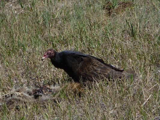
Turkey Vultures teeter on dihedral wings, eyeing us for a future meal. Or,
perhaps they can smell us, and wonder about our "use by" date. (Turkey Vultures are among the few birds that
have a sense of smell. Condors do not, they are more visual creatures.) At Clear Creek camp, we encounter
Jeff and Danny, who are contemplating a butte adventure over to the North Kaibab. Jeff is a friend from the
GCHBA (Grand Canyon Hiker and Backpacker Assoc.) site.
Cool air floods down Clear Creek Canyon and the roll of the creek speeds sleep.
Bodacious Butte Fault - Day 8 photos
Day 9: The Great Unconformity. To Bright Angel (BA) Camp:
9.9 miles; ERM = 18. Camp @ 2400'.
The flank of Hell Gate lords over, or bedevils, us as we rise in the cool
air from the North Rim in the Clear Creek Camp. It's time to hit the trail, an actual trail, with CCC (Civilian
Conservation Corp) manicured tread and all. It's a mild day and the miles roll past, approaching the great
unconformity. We'd already experienced an unconformity with the constructed trail and meeting so many, five
or more, people. Then, walking the Clear Creek Trail, the Great (geological) Unconformity, where billions
(1.2 billion) of years of rock history are missing Or, a few seconds time if you are a religionist. Put
on those sarah palin glasses and you can see time compressed neatly into easy to understand 7-day bits.
Then, we ease into a relatively quiet Phantom Ranch/BA CG, an unconformity
unique to the Grand Canyon. Jarring. Treated water, TP in bathrooms, bathrooms, beer in the cantina, cold beer,
lots of people. And yet, no air tour terrorist unnatural noise. Yes, all sorts of other unnatural noise, but
not the air tour terrorists. This, the most horrid of noise, is reserved for the special wild places. Imagine
that? Unconformity. It would (will?) be so appropriate for all the commercial ventures to share the clatter
and cacophony of decibel-driven excessive profits. But no, it's the most wild portions of the Park that are
so horribly noisy. A republican wet dream. Privatization of gain, socialization of loss. Hear loss included,
no cost to corporate welfare artists.
It's a good afternoon at BA CG. Including an excellent discussion with Bil
Vandergraff of the NPS, years of putting the "service" in National Park Service.
|
|---|
pano-day 9 - along the Clear Creek Trail - scroll L-R to view it
all (4136 x 950 pixels, 1.3mb)
(Click the image for the full-size image)
|
|---|
|
Bodacious Butte Fault - Day 9 photos
Day 10: BA Out:
10.1 miles; ERM = 21.
Out of The Canyon we trek, on super-developed trail, stopping to say "bye"
to Bil Vandergraff at BA and "hello" to Jeff at IG (Indian Garden). Bill feels the rhythm of The Canyon and
walks out in one long motion. Chris and I pause at IG and then move on. We've hiked the Bodacious Butte Fault
and Happy Horsethief Route and celebrate with stew in Cameron. Cameron, one of those miners (mostly mining
tourist) who held The Canyon hostage, keeping it from the public. Sort of like the corporate raiders of today?
Yahoo and exhausted. Recovery takes time after this most bodacious of
adventures.
Bodacious Butte Fault - Day 10 photos
Scenic Toilets of the Bodacious Butte Fault
Turkey Vulture eating road-rolled Raccoon:
As part of my recovery efforts after the Bodacious Butte Fault adventure, I did some
spinning on my road bike. Here is what I saw on one of my rides. It's akin to what corporations do with and to us
every day - pick clean your dead bones ("Corporations are vultures, my friend!" Tadd Romney, 2013).
"Capitalism: Nothing so mean could be right. Greed is the ugliest of the capital sins."
- Edward Abbey
"Reality has a well-known liberal bias."
- Stephen Colbert.
|
|---|
Movie of a Turke Vulture eating a road-rolled Raccoon - 4.4mb
(Click the image to see the short video - 6mb)
|
|---|
|
.
Links:
.
 .
.
You can find Bill's report and superb photos about GC hiking here (click here)
Here is Bill's detailed report about the current trip
The Walcott Expedition, by Dennis Foster (click here)
This link goes to Dennis' Kaibab Journal trip report site.
Maps:
|
|
|---|
Map - Grand Canyon: Mankoweap to Bright Angel; 2013; 78 miles
(Click the image to see the map)
|
|---|
|
for a full-resolution map, click here. Caution - do not use this map or gps track for
navigating the route.
Click here to go to Bill Ferris' day-by-day and overview maps of our route. Bill used my GPS track and his mapping
skills to construct these maps. An internal link references Bill's excellent report and his GC Adventure site.
Caution - again - do not use these maps or gps track for navigating the
Butte Fault Route. It can be a tricky place.
Panos:
Click here to: see a pano day 8 - Hall butte to Angels Gate to Whoton Throne - scroll L-R to view it
all (4222 x 900 pixels, 1.5mb)
Click here to: see a pano-day 9 - along the Clear Creek Trail - scroll L-R to view it
all (4136 x 950 pixels, 1.3mb)
Movies:
Click here to: see a Movie of a turkey vulture eating a raccoon.
Books:
Eaarth : making a life on a tough new planet, McKibben, Bill,
Time Books, 2010.
Maybe one : an environmental and personal argument for single-child families, McKibben, Bill, Simon & Schuster,
1998.
The end of nature, McKibben, Bill, Random House, 1989.
A River Runner's Guide to the History of the GRAND CANYON,
Crumbo, Kim, JOHNSON BOOKS 1880 South 57th Court, Boulder, Colorado, 80301
1994.
Other WV reports about the Grand Canyon:
Click here or on the Looking Lizard to go to all WV reports about The Grand Canyon
|
|---|
Looking for All Wilderness Vagabond trip reports about the Grand Canyon?
Click the image to go to All WV reports about The Grand Canyon
|
|---|
|
Related Links:
Scenic Toilets of Inner Earth
the geology of the Grand Canyon by the NPS
the geology of the Grand Canyon by Bob Ribokas
More Truth Than Joke:

|
|---|
vote republican
(Click the image for the full-size image)
|
|---|
|
|
|---|
brain map of the gop
(Click the image for the full-size image)
|
|---|
|
|
|---|
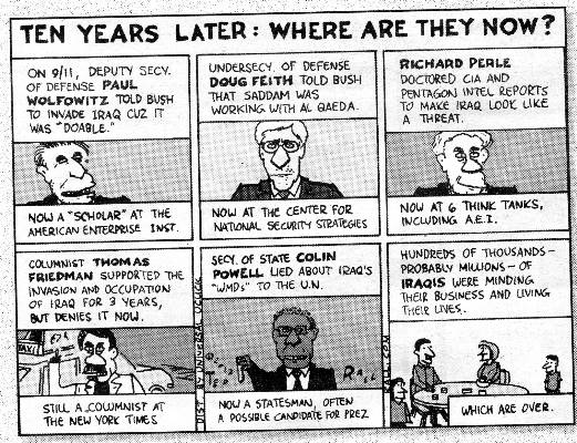
bushco results
(Click the image for the full-size image)
|
|---|
|
|
|---|
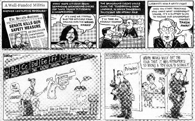
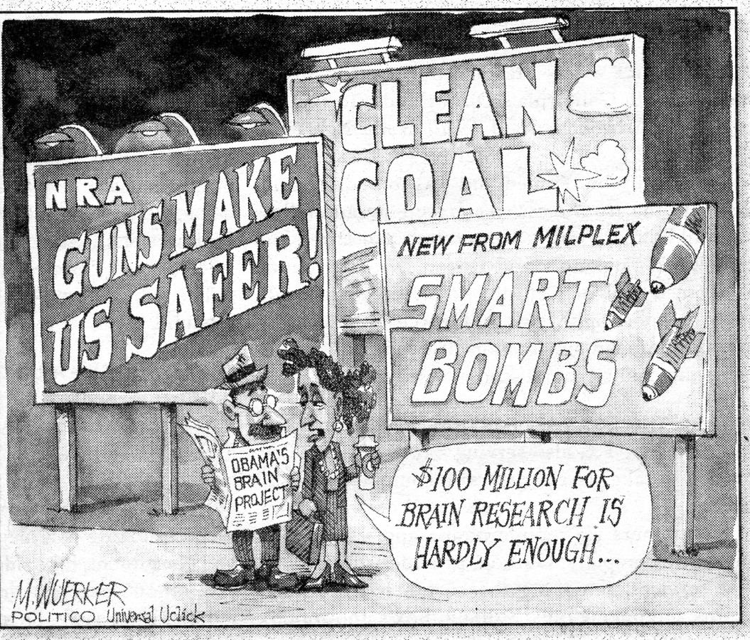
nra has control
(Click the image for the full-size image)
|
|---|
|
|
|---|
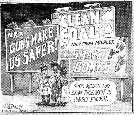
your brain on drugs?
(Click the image for the truth)
|
|---|
|

|
|---|
corporations are (bad) people
(Click the image for the truth)
|
|---|
|

|
|---|
less government?
(Click the image for the truth)
|
|---|
|
|
|---|
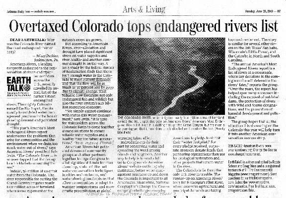
overtaxed Colorado - where is population reduction?
(Click the image for the article - pdf file)
|
|---|
|


