Mazama Meander
A Summer Solstice Soiree: Penetrating Oregon

Pygmy PCT 2018 (PCT is Pacific Crest Trail):
Seiad Valley to Crater Lake; PCT mile 1655.9 to 1821.7
PCT miles = 165.8 miles; Total PCT miles hiked to date = 1,119.5 (42% of the PCT)
ERM (Energy Required Miles) = 265.8
June 23rd to July 7th, 2018
By Wild Vagabond (AKA Rob Jones)

Text and photos © copyright by Rob Jones

Crater Lake, Day 0
Crater Lake, Day 0
(Click the image for the full-size image)
Washington Lily, Day 2
(Click the image for the full-size image)

The PCT, Day 3
The PCT, Day 3
(Click the image for the full-size image)
Crispy Cone, Day 3
Crispy Cone, Day 3
(Click the image for the full-size image)

I see you, Day 6
I see you, Day 6
(Click the image for the full-size image)
Lava and Mt McLoughlin, Day 11
(Click the image for the full-size image)

Devils Peak, Day 13
Devils Peak, Day 13
(Click the image for the full-size image)
Day 14 Morning, Day 14
(Click the image for the full-size image)

Panorama of Crater Lake, Day 16, 5mb, 1200 x 4817
(Click the image to see the full-size image)

.

“There are some good things to be said about walking. Not many, but some. Walking takes longer, for example, than any other known form of locomotion except crawling. Thus it stretches time and prolongs life. Life is already too short to waste on speed. I have a friend who's always in a hurry; he never gets anywhere. Walking makes the world much bigger and thus more interesting. You have time to observe the details. The utopian technologists foresee a future for us in which distance is annihilated.To be everywhere at once is to be nowhere forever, if you ask me.” Edward Abbey

"Estranged from Beauty –
none can be –
For Beauty is Infinity –
And power to be finite ceased
Before Identity was leased."
- Emily Dickinson

Solo Hike

Camera - Panasonic DMC-ZS60

"Between every two pines is a doorway to a new world".- John Muir

     Background: My trail name is Wild Vagabond. Many years ago, I "earned" this trail name in The Grand Canyon, and brought it with me to The PCT. The website name "wildernessvagabond.com" evolved from the trail name. You will see photos of PCT hikers in this report and most are identified by their trail name. Tradition holds that one is given their trail name after some momentous event (and one does not select their own trail name, at least traditionally and per good form).
     A note about Pacific Crest Trail (PCT) miles. Once again, fires and other intrusions (e.g., desertification from global warming) have resulted in rerouting sections of the PCT, changing the mileage. This report uses the new mileage numbers. So, your guide or map numbers may differ from those in this report.
     The ERMs, Energy Required Miles, are calculated using the trusty Half Mile app. One can select two reference points and receive a summary of the elevation gained and lost between theme. And, it's free. Thanks to Halfmile for his dedicated public service to the trail, terrific maps (to print, for the smart-ass) and an app. See the bottom of the report for a description of ERMs.
     On this excursion, I hike from Seiad Valley to the land of Mazama. The trail refuses to go North. Instead, it meanders far East as it approaches Oregon, seemingly avoiding Oregon. The PCT appears to refuse to penetrate Oregon. It's a Mazama meander. Eventually, the PCT penetrates Oregon and one can imagine the squeals of delight.
     My total PCT pygmies include hiking from Kennedy Meadows, South (in California; PCT mile 702.2) to Mazama Village (in Oregon; PCT mile 1821.7), for a total of 1,119.5 miles, or about 42% of the PCT (2650 miles in length), making it cumulatively slightly more than a Pygmy PCT Promenade. 1,119.5 gorgeous miles rambling on our precious public lands, along the Pacific Crest Trail.
     I got into hiking the PCT, in segments, following the Jaunty Juggernaut hike of the John Muir Trail - See the various PCT and JMT reports here ---> All Wilderness Vagabond trip reports about the PCT, JMT, Sierra hikes I used some of the quotes from the JMT report - because they seem quite relevant to this current hike.
     Mazama Meander? Mt. Mazama was the 12,000' peak above what is now Crater Lake. During an eruption of this volcano, Mt. Mazama collapsed into the caldera. Mt. Mazama, nevermore.

Pdf of Mt. Mazama, nevermore. This sequence shows the collapse of Mt. Mazama. From the NPS.

     Maps: I color copied the Halfmile maps and sent sections with the resupply boxes. These paper maps are what I used most of the hiking day. I also used the Halfmile app and found it worked well. I occasionally used the Guthook Atlas Guides PCT app yet it took a very loooooong time to load on my phone and it reloaded far too often (it appears to be optimized for the iphone). You'll see extensive references to the Halfmile PCT mileages in this report. Thanks to Lon Cooper, Halfmile, for his incredible public service to the hiking community. I have to confess that I have started writing journal notes in the dumb-ass phone because the text is easy to export once I get home. And, I can email sections of writing home so that I don't lose any journal notes.
     Here are my journal notes, some photos, and the daily data and trip map, and links to the outstanding Halfmile maps, tracks, and waypoints.

     ERM = Energy Required Miles. A mile is added for every 500' elevation gain or loss. It's a very serviceable method of estimating energy required miles. ERM was initially used in Trails of the Tetons (long out of print) by Paul Petzold, founder of NOLS. It's a wonderfully useful concept and application. Add one mile for each 500' up AND down to distance = ERM. I use ERMs to calculate what the actual day is like. It's a very serviceable method of estimating energy required miles.
     Using ERMs does not account for the 'texture' of the route or trail - that is, rocky, boulders, no trail, slimy mud, etc., yet does help approximate the route.

     There is additional information about the valididy of using ERMS at the end of this report.

Maps for Days 1 - 6: for the wonderful Halfmile maps for section R, California, Start - Seiad Valley, CA; mi 1655.9. End - Hwy 5, mile 1718.9 [near Ashland, OR] these maps cover days 1 to 6 of this hike, click here. Fairly large pdf file. Twelve pages of maps and elevation profiles. Visit pctmap.net for waypoints, tracks, more maps -- for the entire PCT. A super resource. Each of these three pdf files is approximately 20 mb (well worth the digital dithering).

Maps for Days 7 - 11: 54.5 miles; section B, Oregon, Hwy 5, mile 1718.9 [near Ashland, OR]; End - Hwy 140, mile 1773.4 [near Fish Lake], click here. Ten pages of maps and elevation profiles. There is no Oregon section A (it is included in California, section R).

Maps for Days 12 - 15: section C, Oregon, 74 miles miles; Start - Hwy 140, mile 1773.4 (near Fish Lake). End - Hwy 138, mile 1847.8 (near Cascade crest). click here. Sixteen pages of maps and elevation profiles.

movie - Dipper dipping for grub, Day 8; 43 mb
(Click the image to view the movie)

     Preliminary Days:
     At the end of the first day of driving, I'm in Reno, body twitching like an imbalanced sewing machine, mind tumbling and lurching from near caffeine psychosis. Yet I am here after 12 hours on the road and the bulk of the tarmac ordeal finished. Yahoo.
     At the close of the second preliminary day, I'm dodging ravenous mosquitoes, cooking among the big firs and pines and enjoying a well-earned beer, looking forward to an early bedtime in Mazama Village Campground in Crater Lake National Park. I've been to a Crater Lake overlook and up and down the crater hill twice past the Goodbye Picnic Area trying to sort out where to park before meeting Stephen C. tomorrow morning. The first two times I am sent to THs (trailheads) that are closed for construction. The last time I meet Phil G. of the NPS (National Park Service) who radios in and procures a deluxe parking spot in the Mazama Village area. Thanks Phil!
     Then to camp to battle mosquitoes and enjoy some extra examination of the inside of my eyelids.
     Cool moist air settles in, wetting everything out in it.

Muir knows best
Muir knows best
(Click the image to see the full-size image)

"Writing is like the life of a glacier; one eternal grind". - John Muir

PCT 2018 - Seiad to Crater, Prelim Photos

Click thumbnail to see full size image

PCT-2018-day0-1 Crater Lake web.jpg

PCT-2018-day0-2 Crater Lake web.jpg

PCT-2018-day0-3 Crater Lake web.jpg

PCT-2018-day0-4 Crater Lake web.jpg

PCT-2018-day0-5 Crater Lake web.jpg

PCT-2018-day0-6 Goodbye web.jpg

"The mountains are calling and I must go". - John Muir

"Wilderness is not only a haven for native plants and animals, but it is also a refuge from society. It's a place to go to hear the wind and little else, see the stars and the galaxies, smell the pine trees, feel the cold water, touch the sky and the ground at the same time, listen to coyotes, eat fresh snow, walk across the desert sands, and realize why it's good to go outside of the city and the suburbs.". - John Muir
First ascent of El Capitan (Argosy article, 22mb)
First ascent of El Capitan (Argosy article, 22mb) featuring my friend, George Whitmore
(Click the 10 page pdf - 22 MB)

"In every walk with Nature one receives far more than he seeks". - John Muir
(Photos and the report of the trip continue below.)

"Keep close to Nature's heart...and break clear away, once in awhile, and climb a mountain or spend a week in the woods. Wash your spirit clean". - John Muir

     Day 1: The Fern Way: 2.5 miles. ERM = 4.6. To PCT 1658.4 above Fern Spring; Start at PCT mile 1655.9, Seiad Valley. And, a long shuttle. Camp at 2485'.
     As I see a guy carrying a straw hat into the Mazama Store, I yell out of the open window of the Subie Subaru and indeed it's Stephen Clark, trail angel and gentleman farmer. Thus begins the long drive South to Seiad Valley. It feels like a short trip because Stephen is a good conversationalist with a wealth of knowledge about the trail and other interesting subjects.
     Back in the State of Jefferson. I'm getting back on the trail exactly where I stopped last year; the elevation is low, the air hot (probably 95F), and the "no monument" signs dense, so not a pleasant place. Except for the shade and two picnic tables hosting a group of PCT hikers, young people, as you might imagine. I have planned a short hiking day, not knowing when I might arrive, so I dally as the youngsters dally, avoiding the heat and the precipitous climb out of this hell hole.
     I'm the first to venture out of the shade as the young people talk about night hiking. I often find myself thinking of these young people as "youngsters," although I doubt they would use this term. My knees and back, and especially my feet, tell me they'd like to be in the youngster category. I've discovered, over and over, that one has difficulty training their feet. What? Yes, all through my early hiking career I tried all sorts of boots, boots with two insoles, etc. Eventually I realized I needed to hike with women's boots because of my narrow, low volume foot, and that my high arches made my feet prone to plantar fasciitis - resulting in custom orthotics and stretching. Awful stuff. So, I would like to hike more miles yet my feet say "whoa there, you're not going without us and we say "No!"" Besides, the journey is the destination and trail tunnel vision is the bane of enjoying the journey.
     A bit of road walking and the trail starts up and will continue up over the next 10 miles and nearly 5,000 vertical feet. Argh. Yet for me today, Fern Spring is the goal.
     The trail is well graded and up, climbing above the raucous Klamath River. This sounds alluring, yet it's the tinkle of piped Fern Springs that is refreshing. I load up with filtered water and climb to the next decent place to camp, everything being on an incline in this stretch. A proliferation of poison oak lines the trail.
     Small mosquitoes try to assault me as I prepare dinner, and they are wimpy relative to the squadrons of monster cousin mosquitoes at Crater Lake. My skin itches in several bumpy spots because of proboscis punctures, courtesy of the Crater Lake squadron.

"“What would it be like to live in this place? Could a man ever grow weary of such a home? Someday…I shall make the experiment, become an ancient baldheaded troglodyte with a dirty white beard tucked in my belt, be a shaman, a wizard, a witch doctor crazy with solitude, starving on locusts and lizards, feasting from time to time upon lost straggler boy scout. Madness: of course a man would go mad from the beauty and the loneliness, both equally mysterious. But perhaps it would be – who can say? – a kind of blessed insanity, like the bliss of a snake in the winter sun...”. - Edward Abbey

"The world is big and I want to have a good look at it before it gets dark". - John Muir

PCT 2018 - Seiad to Crater, Photos Day 1

Click thumbnail to see full size image

PCT-2018-day1-1 Steve C angel web.jpg

PCT-2018-day1-2 Seiad Val web.jpg

PCT-2018-day1-3 trash resting web.jpg

PCT-2018-day1-4 destruction web.jpg

PCT-2018-day1-5 Klamath web.jpg

PCT-2018-day1-6 flower web.jpg

PCT-2018-day1-7 Fern Sp web.jpg

PCT-2018-day1-8 showy web.jpg

PCT-2018-day1-9 Tohee web.jpg

     Day 2: A Devil of a Day. To Kangaroo Spring: PCT mile 1666.0, the Devil's sign. 7.6 miles. ERM = 15. Camp at 5680'.
     The wind nearly blasts me off the trail as I inch up and around yet another Devil Peak. Lower, Middle, Upper Devil Peak.
     It's a flowerfest day climbing up through the ecozones. Washington Lily, Paintbrush, Yarrow, a variety of sunflower relatives, gentians, Larkspur, orchids, Columbine, Pussy Paws, Lupine, California Corn Lily, and lots I cannot identify. Later in the trip I also see Wild Iris, Arrowleaf Balsamroot, Horse Mint, Shooting Stars, orchids, Phlox, Dwarf Lupine, Mules Ears, California Lilac, Death Camus, Hookers Onion, Skyrocket, gentians, and more. It's a fine field example of C. Hart Merriam's Life Zone concept (1889), as described in this report about the Circumnabulation of San Francisco Mountain.
     Shasta is on the Eastern horizon as Fireproof (photo) stops to chat, telling me how he had just encountered a rattlesnake, probably one that I stirred up in passing. A grouse and a Spotted Towhee make the climb more enjoyable. It's good to be out of the oppressive heat of Seiad.
     I'm lounging in the shade near Kangaroo Mountain eating lunch #2. The Boundary Trail junction is also nearby, as is a view of Red Butte through this low pass. At 5890', this appears to be the high point of the climb out of sad Seiad, over 4700' below. Back on the trail, I peek over the low ridge at Shasta and see Shasta and a plume of smoke. Yikes. The smoke appears to be coming from where the PCT leaves the road walk. Yikes again. I later learn that a small sawmill had started on fire, accompanied by exploding propane tanks and ammunition. Just a typical afternoon for the local fire brigade. Another fire starts in a few days, threatening to close the trail (the PCT).
     Dropping into a narrow basin below Red Butte, I'm soon at the tiny pond of Kangaroo Spring. Decent by Arizona Trail standards mediocre by Sierra standards. Camping is nice. It's hot, into the afternoon and the next water is near a dirt road. What to do?
     I awake to the realization that I've been napping in the shade of a friendly pine. Flies buzz past, yet there aren't any mosquitoes, at least not yet. Maybe this is camp for the night? Besides, a warm bucket bath will feel terrific. And it does feel good. By the time I am finished futzing with treating water, bathing, setting up camp, it's approaching dinner time. During my water gathering, I see a baby water snake resting on lily pads. Cute, and alas no camera.
     With a recognition of the short dark hours in this time of the Solstice, I get into the bag with sunset only to be awakened in the dark by chortling and coughing from something large and close by. A bear gagging on my food bag? Naw, it's safely suspended in a tree. A deer or hiker with some sort of lung disease? I peer out of the tent, cannot see anything despite the full moon and my headlamp. It moves away. Later, yuge clattering wakes me again. Something is scrambling in the rocks near the trail. Again back to sleep and then there's a shrieking alarm call, of which I hear only part - because I'm, sigh, sleeping. Morning comes too soon, painting Red Butte, well, red.

Yummy, sandwiches
Yummy, sandwiches
(Click the image to see the full-size image)

"This I may say is the first time I have been to church in California". John Muir, after making the first recorded ascent of Cathedral Peak in 1869.

PCT 2018 - Seiad to Crater, Photos Day 2

Click thumbnail to see full size image

PCT-2018-day2-1 Klamath web.jpg

PCT-2018-day2-2 Grouse web.jpg

PCT-2018-day2-3 Paintbrush web.jpg

PCT-2018-day2-4 Washington Lily web.jpg

PCT-2018-day2-5 precious web.jpg

PCT-2018-day2-6 Lizard web.jpg

PCT-2018-day2-7 moth web.jpg

PCT-2018-day2-8 Shasta and Lily web.jpg

PCT-2018-day2-9 Fireproof web.jpg

PCT-2018-day2-10 tenting web.jpg

PCT-2018-day2-11 obtaining the ridge web.jpg

PCT-2018-day2-12 footnote to the future web.jpg

     Day 3: Bear Dogging The Trail. To Bear Dog Spring: PCT 1676.2. 10.2 miles. ERM = 18. Camp at 6100'.
     Bufus Bear was here last night or early this morning, his tracks tell the tale. And a sizeable Bear too. Perhaps Bufus made the coughing sounds last night? Maybe it's Bear Dog heading to her spring?
     Around eponymous Lily Pad Lake I lilt, amidst a continuing flowerfest before climbing to near the Echo Lake junction. Then a steady downhill through an incinerated forest of standing black toothpicks (this fire was last year) to a pass and dirt road crossing, Cook Green Pass, at 4700'. After lunch #1, it's up to 6100', regaining the lost elevation and more.
     Lunch #2 affords yet another view of Mt Shasta, near the Copper Butte Trail. The wind blows cool, cold until I change out of the wet shirt. It's a land of schist; or, a schisty land, made more stark by the mosaic of fire damage.
     Jo comes along, heading from Castle Crags to Canada. I also encounter 2 Forest Service biologists checking to see how an endangered plant is coping after the fire.
     As I near Bear Dog, I see a field of Pussy Paw flowers holding their "paws" above the hot ground. Apparently, the paws are cozied near the ground when cool and held aloft when the ground is hot. Amazing adaptation.
     Bear Dog Spring hosts crisp clear water and marginal camping. So, I go exploring for Louden's Cabin shown on the map as being across the drainage and below. What I find is an old sign hanging by one bent nail from a tree proclaiming "Loudens Cabin," perhaps the base of a chimney, and a yuge pile of fresh Bear scat. And, no good camping here.
     Back on the PCT, I circle back to Bear Dog and make do with a small camp in the firs, out of the wet meadow created by the spring and well screened from the wind.

"The power of imagination makes us infinite". - John Muir

PCT 2018 - Seiad to Crater, Photos Day 3

Click thumbnail to see full size image

PCT-2018-day3-1 morning glow web.jpg

PCT-2018-day3-2 morning web.jpg

PCT-2018-day3-3 bufus rear web.jpg

PCT-2018-day3-4 bufus front web.jpg

PCT-2018-day3-5 flower web.jpg

PCT-2018-day3-6 along the crest web.jpg

PCT-2018-day3-7 gentian web.jpg

PCT-2018-day3-8 flower web.jpg

PCT-2018-day3-9 Lily Pad Lk web.jpg

PCT-2018-day3-10 flower web.jpg

PCT-2018-day3-11 toasted web.jpg

PCT-2018-day3-12 columbine web.jpg

PCT-2018-day3-13 orchid web.jpg

PCT-2018-day3-14 flower web.jpg

PCT-2018-day3-15 beyond the pass web.jpg

PCT-2018-day3-16 flower web.jpg

PCT-2018-day3-17 Jo web.jpg

PCT-2018-day3-18 steaming pile web.jpg

     Day 4: Donomore Or Bust. To Donomore Creek and Meadows: PCT mile 1690.5. 14.4 miles. ERM = 25. Camp at 5625'.
     The Pussy Paws are hugging the ground and I'm wearing an extra shirt, after just slipping off the down jacket this chilly morning. Off around White Mountain and then the climb over Condray Mountain on the way to Alex Hole I hike. Nearing Alex Hole, I meet PCT Trail Volunteers and FS grunts Ben, Caius, Kelly, and Ruth and we talk about hikes and volunteering. Thanks for your stewardship of our precious public lands and the PCT. You'll see some of my volunteer efforts among the trip reports about The Canyon, Grand Canyon National Park (link)
     There are Shooting Stars in the boggy region of Alex Hole, yahoo. A Stellars Jay comes to talk with me as I try for yet another flower photo.
     Continuing North, a lovely aroma wafts up from the field of dwarf lupines dotted with Pussy Paws and some undiscovered composite. Lovely.
     Arriving at Mud Spring, I find the water difficult to gather and salted with bits of dirt and the camping excellent yet right on what appears to be an ORV (Off Road Vehicle) carnage-way, so I move along to a superb view of (you guessed it) Mt Shasta for lunch #2.
     Eric (Eko), comes along from the North and we enjoy some plant talking.
     Evaluating the water sources, I head for Bear Ground and the springs depicted on the reliable Half Mile paper maps.
     A foot break and another liter of mango green tea and a glance at the time and the elevation change to Donomore Creek convinces me, Donomore or bust.
     Now ensconced in the big trees safely above the meadow and cold air slump of Donomore Creek, I feel a bit of the bust.

"Thousands of tired, nerve-shaken, over-civilized people are beginning to find out going to the mountains is going home; that wilderness is a necessity..". - John Muir

PCT 2018 - Seiad to Crater, Photos Day 4

Click thumbnail to see full size image

PCT-2018-day4-1 shadow web.jpg

PCT-2018-day4-2 hearts web.jpg

PCT-2018-day4-3 Ben, Caius, Kelly, Ruth web.jpg

PCT-2018-day4-4 Shooting Star web.jpg

PCT-2018-day4-5 flax web.jpg

PCT-2018-day4-6 Eko web.jpg

     Day 5: Oregon! To PCT 1703.9, West Branch of Long John: 13.3 miles. ERM = 22. Camp at 5950'. Eclipsing 1,000 total miles on the PCT.
     The Coyote chorus echoes across Donomore Meadow; different individuals chiming in to a Song Dog crescendo. Wonderful. The chorus goes on for about 5 minutes; apparently the group is sorting a tricky social issue.
     Back on the trail, I soon encounter Offenbacher Cabin and its scenic toilet. Signing in the cabin log book, I thank the Offenbachers for sharing their heirloom cabin with hikers.
     Then - penetrating Oregon! A hodgepodge of rickety signs announces the California/Oregon border. Yowee. It often felt like Oregon was out of reach during previous hiking escapades; now this hike continues in Oregon.
     I meet Seasoned Strider and Gadget Girl, hiking sections South.
     There's a magnificent gusher at Sheep Camp Spring and just right for a long break and snack #1.
     As I get back on the trail, along comes Phoenix (Lionel Pittet) from Switzerland. We hike together for a few miles, Phoenix being kind enough to slow his pace a little. We enjoy lunch #2 overlooking Mt. Ashland, the Monogram Lakes basin, and a distant Mount McLoughlin, which is North, near Fish Lake. Somewhere along this stretch, perhaps the trail ceases the Eastern meander and begins going North? Hah.
     Phoenix hikes on and Smalls and Heart Rock appear. We're all going to the West Branch of Long John, which turns out to be a tiny yet welcome trickle.
     It's cool enough to wear a wool hat and a few clothing layers during dinner. The vigorous wind ushers in a fairly complete cloud cover.

movie - Coyote Chorus, Day 5; 33 mb
(Click the image to view the movie)

"The grand show is eternal. It is always sunrise somewhere; the dew is never dried all at once; a shower is forever falling; vapor is ever rising. Eternal sunrise, eternal dawn and gloaming, on sea and continents and islands, each in its turn, as the round earth rolls". - John Muir

PCT 2018 - Seiad to Crater, Photos Day 5

Click thumbnail to see full size image

PCT-2018-day5-1 Offenbacher Cabin web.jpg

PCT-2018-day5-2 Oregon web.jpg

PCT-2018-day5-3 Oregon web.jpg

PCT-2018-day5-4 Iris web.jpg

PCT-2018-day5-5 Seasoned Strider, Gadget Girl web.jpg

PCT-2018-day5-6 flower web.jpg

PCT-2018-day5-7 Horse Mint web.jpg

PCT-2018-day5-8 Phoenix web.jpg

PCT-2018-day5-9 Smalls, Heart Rock web.jpg

     Day 6: Siskiyou to You. To Callahan's Lodge (resupply): PCT mile 1718.7 (plus 0.8 mile road walk). 14.8 miles. ERM = 25. Camp at 3950'.
     The cold fogbank envelopes me as I hike the ridge near Mt Ashland. Eerie and brisk. One can imagine walking the moors of Wales, fog and mist swirling, objects emerging, fading into the miasma. Fascinating.
     As I drop into a gap, I head for Grouse Gap Shelter and toilet. Here I see Ben and Caius working near the shelter amidst frigid wind. Ben talks of a possible PCT closure from a new fire along the Klamath River, not far from sad Seiad. Oh no, perhaps another horrific fire year for the PCT and our public lands is starting?
     As I am just about to hike out of the forest and onto BLM and private land, I hear the growl of a chainsaw and soon see Ruth and Kelly wrestling with a down tree that is blocking the trail. More discussion ensues, then a final goodbye.
     Down, down into the relative heat of Toll Road Gap and the chaos of Interstate 5.
     Road walking old hwy 99 to Callahan's alongside the thundering tarmac known as Interstate 5 isn't fun, and my feet demand a break. The tarmac leads down below 4,000', a low point of this trip (after sad Seiad).
     Setting up the tent near the white noise of an artificial water falls seems a way to mask some traffic noise.
     Shower, laundry, dinner, spectacular.
     An excellent way to end a day of roaming the Siskiyou Mountains.

PCT 2018 - Seiad to Crater, Photos Day 6

Click thumbnail to see full size image

PCT-2018-day6-1 foggy web.jpg

PCT-2018-day6-2 foggy web.jpg

PCT-2018-day6-3 foggy ridge web.jpg

PCT-2018-day6-4 Skyrocket web.jpg

PCT-2018-day6-5 Lupine web.jpg

PCT-2018-day6-6 Ruth, Kelly web.jpg

PCT-2018-day6-7 footnote to Shasta web.jpg

PCT-2018-day6-8 broad valley web.jpg

PCT-2018-day6-9 watcher web.jpg

PCT-2018-day6-10 wagon road web.jpg

PCT-2018-day6-11 Oregon Grape web.jpg

PCT-2018-day6-12 Kelly web.jpg

     Day 7: Piloting The Peak. To Piped Spring at PCT 1728.1: 9.7 miles. ERM = 15. (plus 0.8 extra road walking from Callahan's to the PCT). Camp at 5350'.
     The day starts with an Ed Abbey discussion with Kelly, this time a guy, hiking an often vague trail connecting Oregon wilderness areas. "Listening for Coyote" by William Sullivan - is the book about this trail. I look forward to Kelly sending an update and the track for this trail or route.
     The scenic toilet is somewhat discretely situated behind a tree at the edge of the Soda Mountain Wilderness Area. Gorgeous, yet with a limited view. The character of the toilet makes up for what it lacks in vista. It's an al fresco toilet.
     I continue sauntering around the corner of Pilot Peak, resplendent with a columnar basalt flank, after arranging a scenic toilet photo. It's well into the afternoon and it's about 7 miles on trail so far today, a figure typically accomplished before noon. However, Kelly, Reed, and I start the day with a pancakes (all you can eat!) and eggs hiker breakfast at Callahan's, and I don't get on the trail until late morning. Last night I dined with Jimmy C. and wife, where I gorged on two plates of spaghetti, two mini-loaves of bread, and a salad. Just right. (Two meals are part of the hiker special combo at Callahan's).
     The stop has been excellent, yet it comes with a resupply and now my pack is again an obese brick on my back and slightly bruised feet. Argh.
     A hoard of butterflies swarms a patch of Horse Mint as I amble along the trail, rolling through dry grasslands and sweet dark forests. I am fascinated by the mints, because a true mint has a square stem, totally square - give it a feel some day; yet don't try this with the nettles, which have a resemblance to mints, because that's an irritating venture. Paul C. stops for a brief chat.
     Arriving at the first water (and last for another 13 miles), I call it good enough.
     Papa Bear and Sweet Pea roll in at sunset.

PCT 2018 - Seiad to Crater, Photos Day 7

Click thumbnail to see full size image

PCT-2018-day7-1 Kelly notes Day 7 web.jpg

PCT-2018-day7-2 layered web.jpg

PCT-2018-day7-3 onion family web.jpg

PCT-2018-day7-4 teasel web.jpg

PCT-2018-day7-5 heart leaf web.jpg

PCT-2018-day7-6 puffer web.jpg

PCT-2018-day7-7 columnar Pilot Pk web.jpg

PCT-2018-day7-8 scenic toilet web.jpg

PCT-2018-day7-9 Paul C web.jpg

     Day 8: One Soda, Please. To Little Hyatt Reservoir Outlet PCT 1741.2. 13.1 miles. ERM = 21. Camp at 4650'.
     The trail has piloted a meander to the North side of Pilot Peak and Mount Ashland. When will this trail go North? It's been winding, meandering East for many days.
     Leaving Soda Mountain Wilderness, I think about sipping the creme soda left by the Trail Angels near Mount Ashland. Yummy. Fond memories.
     As I cross the road near Keene Creek Reservoir, I see a lovely field of flowering Mules Ears brightening the place. Showey. Smalls and Heart Rock (she collects rocks in the shape of hearts) are eating the last of the cinnamon rolls brought by their husbands to the road crossing near Keene. A beyond deluxe way to travel, I muse with envy.
     On the trail goes, around and almost onto Green Springs Mountain before dropping into Hyatt Meadow and to the outlet of Little Hyatt "Lake," which is enlarged by a cement plug. Ahh water.
     So, I'm lounging streamside, when who should appear but an oily bird plucking bugs underwater, oh dear. Seussical. It's a dipping Dipper, or Water Ouzel, and she's putting on a display of water prowess. Amazing. I shoot a variety of videos, each one seemingly better than the last. Wow. Of course, this elegant bird is nothing like the oleaginous fake christian mike pence, who is a despicable sort of evil oiliness.
     The water sources are few and stretched out over long distances in this section to Fish Lake; and there's no reported water for 10 miles. So, I opt to stay nearby and I'm rewarded with a warm and pleasant bug free and calm evening within earshot of the falls produced by the dam spillway. Delightful.

"Not blind opposition to progress, but opposition to blind progress..". - John Muir

PCT 2018 - Seiad to Crater, Photos Day 8

Click thumbnail to see full size image

PCT-2018-day8-1 wildflowers web.jpg

PCT-2018-day8-2 flower again web.jpg

PCT-2018-day8-3 Mules Ears web.jpg

PCT-2018-day8-4 friend web.jpg

PCT-2018-day8-5 Little Hyatt web.jpg

PCT-2018-day8-6 Little Hyatt web.jpg

PCT-2018-day8-7 Dipper web.jpg

PCT-2018-day8-8 Dipper web.jpg

PCT-2018-day8-9 Dipper web.jpg

     Day 9: Grizzly Day. To Grizzly Creek, PCT 1751.1: 9.9 miles. ERM = 15. Camp at 4500'.
     The vapors rise over Little Hyatt Outlet as the low climb over to Hyatt Reservoir begins. Soon, however, I'm down to a single shirt.
     The junction near the entrance to the campground at Hyatt Reservoir is strangely quiet, and I wonder if the campground is closed. This seems likely when I see the skeletal deer head in the water trough along the trail. Lots of water down below, yet little away from the reservoir.
     During a foot break, I admire the cinnamon stick Red Cedars and the outlandish display of flowers that grace these drying hills.
     Without much for views, except for the big monarch Douglas Fir and Red Cedar Trees, the trail rolls along to the eerily quiet, yet full aqueduct from Howard Prairie Lake and shortly thereafter diminutive Grizzly Creek.
     Once again, the next water is somewhat distant, and timing of the remaining single possible source near Brown Mountain Shelter difficult for a not long distance hiker like me. So, it makes sense to stay here rather than press on into the heat. Besides, the trail next climbs 1500' or so feet in elevation before rolling to the shelter.
     So, I have time for a bucket bath after a lengthy exploration for a decent campsite. Perhaps I should have stayed in one of the developed campsites along the way?
     The trail is very quiet today, and I see only one backpacker and a few day hikers. It's a pleasant day without exciting animals or situations. I did lose another water container to puncture, this time a Sawyer. Two down.

"What luck for the rulers that men do not think". - Adolph Hitler

"One should go to the woods for safety, if for nothing else". - John Muir

     Day 10: Treebeard to Brown Mountain Shelter. To near Brown Mountain Shelter: PCT mile 1763.5. 12.4 miles. ERM = 19. Camp at 5250'.
     The silky, cool, crisp, clear water curves from the pipe with a gentle burble. Delightful. This water at Spring 1755.2 is most excellent water and the last until the possible water beyond the Brown Mountain Shelter and maybe until the Fish Lake area.
     And, this spring marks roughly 100 miles on this pygmy PCT adventure.
     It's a day of trees and more trees; so many yuge trees that the solar panel is struggling to get a decent charge. Many of the trees are festooned with strands of light green moss, decked out like tinsel trees, without the glitter. Treebeard. I pause for a long break, partly to get some sun on the panel.
     When there is a gap in the tree cover, what do I see but Mount Shasta gleaming serene.
     After a long lunch #2 at a road crossing, urging the solar panel to do its thing, I continue to Brown Mountain Shelter. Although I search for awhile, I cannot find a scenic toilet near the shelter. Huh?
     At the next road crossing, I find the fabled last water until the Fish Lake/Hwy 140 area and a place to camp. According to notes by Optimistic Turtle, there is an eight mile stretch of lava coming to the trail and starting in a half a mile from here.
     As I'm goofing with the water. I meet and talk with Desmond 29 Out of Germany, and Nutter Butter and Ham Bone.
     It's growing cool as I clean up the dinnerware, so I hurry toward the tent and bag at the end of this tenth day on the Pygmy PCT.

PCT 2018 - Seiad to Crater, Photos Day 10

Click thumbnail to see full size image

PCT-2018-day10-1 spring fed web.jpg

PCT-2018-day10-2 marker web.jpg

PCT-2018-day10-3 Brown Mtn Shelter web.jpg

PCT-2018-day10-4 Desmond 29 web.jpg

PCT-2018-day10-5 Nutter Butter, Ham Bone web.jpg

PCT-2018-day10-6 lily web.jpg

     Day 11: Lava Romp. To Fish Lake Resort (resupply): PCT 1773.2. 9.7 miles (plus 2 miles access trail to the resort). 11.7 miles. ERM = 14. Camp at 4850'.
     I have on all my clothes and hiking the dark treebeard forest, wondering if the lava field supposedly ahead will allow the sun to heat my bones and other parts.
     Along comes Pusher from Germany, teeth almost chattering. He pushes on and I put my gloved hands in my pockets.
     It does warm in the sun glinting off the black basalt. Lovely.
     I hike awhile with Trish, Fire Woman and Paul, NoHawk (a geologist) and NoHawk points out a collapsed lava tube.
     Occasional Sugar Pine giganto-cones dot the lava swales and forest incursions. NoHawk notes that these spiny rubble depressions were formed by the surface of the lava cooling and the still hot magma underneath flowing out. Amazing diversity. Some might call this area desolate, yet, as Trish points out, it is fascinating. And, the hours and effort to create this trail are astounding. I enjoy my time with these hikers, yet we part ways at the side trail to Fish Lake. So long and take care.
     Something other than Mount Shasta appears; Mt McLoughlin. Hurrah.
     I hike the path off the PCT to Fish Lake Resort for resupply, lunch, charging phone and panel battery, and a shower. Reportedly, there are numerous mosquitoes back up on the PCT near the canal (water source) and it's getting late in the day, so I lug the resupplied pack plus water part way around Fish Lake to a camp with a moderate amount of bugs.
     Mount McLoughlin is a steep-sided stratovolcano, or composite volcano, in the Cascade Range of southern Oregon and within the Sky Lakes Wilderness. It is one of the volcanic peaks in the Cascade Volcanic Arc, within the High Cascades sector.
     I meet Matt at Fish Lake while I'm sorting out items from my resupply box, charging the phone, eating a meal. Later, I'm camped with Matt on the bank of Fish Lake. Matt is on a 40+day quest to answer some questions and escape the shallowness of the false bravado (facebook; and their ilk). He shows a video of a Yosemite Bobcat with a squirrel it captured in front of his tent. Amazing. Here's hoping that the same fate awaits all camp robbing furry-tailed rats.

PCT 2018 - Seiad to Crater, Photos Day 11

Click thumbnail to see full size image

PCT-2018-day11-1 Color lump web.jpg

PCT-2018-day11-2 Pusher web.jpg

PCT-2018-day11-3 Fire Woman, No-Hawk web.jpg

PCT-2018-day11-4 Internal branches web.jpg

PCT-2018-day11-5 Mt McLoughlin web.jpg

PCT-2018-day11-6 Matt web.jpg

     Day 12: Sky High Lakes. To Christi's Spring: PCT mile 1784.9. 11.7 miles. (plus 2 miles up to the trail from the resort; 13.7 miles) 13.7 miles. ERM = 16.7. Camp at 6290'.
     As I approach the boundary of the Sky Lakes Wilderness, I meet Allan and Lea, two energetic and positive people whom are delightful to meet and talk with. They're camped along the rushing Cascade Canal and have enjoyed the background noise of this creek, which is not far from the Hwy 140 crossing.
     Mosquitoes occasionally ambush me on the trail and are uncharacteristically absent at other times. The grade is up, up somewhere over a thousand feet to the McLoughlin junction. Up more later.
     Next, I encounter Angie and Dana, hiking with pupster. They placed a food cache in a 5 gallon plastic bucket and a Bear, apparently, took a nip of it, without getting to the food. Not a very determined Bear.
     As I approach Twin Ponds junction, the mass of trees thins enough to get a glimpse of conical Mt McLoughlin, but not much of a view. The map says that there are lakes about, yet there are too many trees to see much of anything but trees. Twin Ponds/Summit Lake junction is just right for lunch #2. Mosquitoes greet me, then mystically depart so I enjoy a pleasant lunch.
     The trail continues, slower now, to Christi's Spring where I find Lea and Allan taking a break in their tent. Mosquitoville. They wrap up and continue to the Red Lake diversion off into a lake basin and then back on the PCT while I filter water and backtrack on the trail to a camp I hope hosts a moderate amount of bugs.
     Along comes Matt and he also stays in this camp.
     It's good to have a tent with full bug netting.

PCT 2018 - Seiad to Crater, Photos Day 12

Click thumbnail to see full size image

PCT-2018-day12-1 Matt web.jpg

PCT-2018-day12-2 Allan, Lea web.jpg

PCT-2018-day12-3 Angie, Dana web.jpg

     Day 13: And Lucifer Preceded The Devil. To the first creek North of Christi's: PCT mile 1799.3. 14.4 miles. ERM of 22. Camp at 6756'.
     A quartet of toads bark into the dawn, waking me, and I can tell they also wake Matt. Time to get on the long trail for today.
     The route starts through dense forest, then opens to a distant view of what else but Mt Shasta, albeit more and more distant. Then comes a look at the other side of Mt McLoughlin.
     The journey today then goes through a pass below Luther Mountain into a whole new vista. First, of fire damage for about 2 miles, including the top of the trail steeply down into the Snow Lakes. Initially, I planned to stay at a Snow Lake, yet looking down into the basin, I think not. Besides, there's good flowing water predicted ahead. So, go for the creek North of the planned stop.
     The trail continues through the saddle below Lucifer, on the way to Devil Peak before dropping into the basin where there is water, precious water. The vista opens more as the PCT climbs nearly over Shale Butte, skirts part of Lucifer, and tops out near Devils Peak before dropping past a rare diminutive snowbank to the creek at PCT 1799.3. Matt continues to one of the next water stops, trying to get close to the land of Mazama. This camp features a ranging vista to beyond Crater Lake, although I am not sure what I am seeing. Perhaps it is possible to see the edge of the caldera? Anyway, it's an expansive and deluxe vista.
     An orange fireball sunset closes out this long day, indicating that there are fires in the area. When I'm almost asleep I smell smoke from the fire that contributes to the saturated color of the orange fireball sunset.

PCT 2018 - Seiad to Crater, Photos Day 13

Click thumbnail to see full size image

PCT-2018-day13-1 Golden Mantle web.jpg

PCT-2018-day13-2 heart-like web.jpg

PCT-2018-day13-3 flower web.jpg

PCT-2018-day13-4 paintbrush web.jpg

PCT-2018-day13-5 flower web.jpg

PCT-2018-day13-6 flower web.jpg

PCT-2018-day13-7 pollinator web.jpg

PCT-2018-day13-8 Devils web.jpg

PCT-2018-day13-9 burnout web.jpg

PCT-2018-day13-10 Sky Island web.jpg

PCT-2018-day13-11 passage web.jpg

PCT-2018-day13-12 passage web.jpg

PCT-2018-day13-13 pass web.jpg

PCT-2018-day13-14 camp web.jpg

PCT-2018-day13-15 fireball web.jpg

     Day 14: Ghost Tree Graveyard. PCT mile 1810: 10.7 miles. ERM of 15.5. Camp at 6250'.
     As I fish out the next three mosquitoes from the cocoa, the orange-pink light fades to a blue-gray. It's morning on Day 14. I got up before dawn to attempt to photograph the morning hue and I was ambushed by squadrons of mosquitoes.
     Teetering down the trail with a full load, 7 liters, of water; because of uncertainty about water at Jack Spring, seems like a necessary precaution.
     I again see Matt, and as we are talking Bear from Michigan arrives and we discuss the dangers of working for amoral immoral, I suppose most all of the, corporations.
     A California Toad leaps into the trail and nearly underfoot. Here, I believe, is the barking toad that interrupted the morning bliss of morning on Day 13.
     A mosaic of burned and green areas appears about 1.7 miles South of the Jack Creek Spring Trail, soon followed by a totally toasted section sporting weathered ghost trees. Jack Spring Trail is in the toasted segment. So, I don't stop to check on the spring because the area looks like a moonscape. A positive note, the mosquitoes don't like the area either. This is a grand discovery because I have sufficient itching bumps on my body parts for the duration of the adventure.
     It will be a mosaic of toasted and green sections for several miles and I pick an untoasted place to camp. It's a section sporting Lodgepole Pines in the Oregon Desert (yes, that's the official name on the map, Oregon Desert).
     Perhaps I could jettison the extra water and hike fast to Mazama Village, yet it's a bit late, hot, and I feel a responsibility to use the massive poundage of water I've toted here.
     There's a hint of smoke stink in the general overcast, and the clouds again conspire to inhibit the solar system from obtaining a full charge. Two young women stop while I am at lunch #3 to ask about the status of the Bend Fire. Maybe that's it?
     So, I while away the remainder of the afternoon amidst a Lodgepole Pine forest, checking these journal notes.
     Wow, it's wonderful to camp without mosquitoes, here in the part of the former forest labeled as "Oregon Desert" on the topo map.

PCT 2018 - Seiad to Crater, Photos Day 14

Click thumbnail to see full size image

PCT-2018-day14-1 morning, Day 14 web.jpg

PCT-2018-day14-2 speckled web.jpg

PCT-2018-day14-3 Oregon web.jpg

PCT-2018-day14-4 Bear web.jpg

PCT-2018-day14-5 feed web.jpg

PCT-2018-day14-6 CA Toad web.jpg

PCT-2018-day14-7 CA Toad web.jpg

PCT-2018-day14-8 Matt, new use web.jpg

PCT-2018-day14-9 moonscape web.jpg

PCT-2018-day14-10 moonscape web.jpg

PCT-2018-day14-11 sky seekers web.jpg

PCT-2018-day14-12 coming back web.jpg

     Day 15: Mazama Completion, For Now. To Mazama Village: PCT mile 1821.7. 11.7 miles (plus 0.7 to the camp). ERM = 18. Camp at 6020'.
     Starting out from the bug-free Oregon Desert, I suffer frozen toes; they warm quickly once I'm hiking.
     There's more hiking in the toasted obstacle course. As trees clear, Union Peak juts up like a shark tooth. The burn has cleared openings for forbs and a delicious Lupine aroma fills portions of the early walk.
     And, it's a quiet trail; I see only one other hiker until I approach Highway 62. I get off at the Annie Springs turn and to Mazama Village, completing the Mazama Village - Penetrating Oregon - Pygmy PCT 2018. At least for now. Yes, I intended to hike through the Park, to the North border, yet this was not to be.
     Yet, this is another terrific jaunt on the Pacific Crest Trail, hiking a backbone of America's public lands. Let's all walk free, with a government that protects us from the ravages of evil corporations (most of this amoral, immoral cabal) everywhere. A government of or elected by billionaires is not a government of the people. Hike on.

PCT 2018 - Seiad to Crater, Photos Day 15

Click thumbnail to see full size image

PCT-2018-day15-1 dark morning web.jpg

PCT-2018-day15-2 Lupine web.jpg

PCT-2018-day15-3 Union Pk web.jpg

     Postlog:
     I comb my hair at the entrance to Mazama Village and grab the geezer pass (not needed, I'm already in the Park). I have mixed feelings, a paisley contrast of emotions; it's good to be starting home to help, it's sad to be leaving the trail.
     At the hiker/biker campsite, I again see Kyle and this time I get his photo. He's temporarily off the trail because of an injured knee.
     I set up at hiker/biker camp and enjoy a short shower. Wondrous.
     Over for dinner at Annie's. I again see some of the hiker friends from the trail while camping at the hiker/biker site in Mazama Village. Sad to say, I'll never again hear from anyone I meet on the Trail this trip, and this makes me feel sad indeed.
     The next morning I head to Burney - It's to the Green Gables Motel because they did a wonderful job of storing the Subie last year. But first, I drive around the 
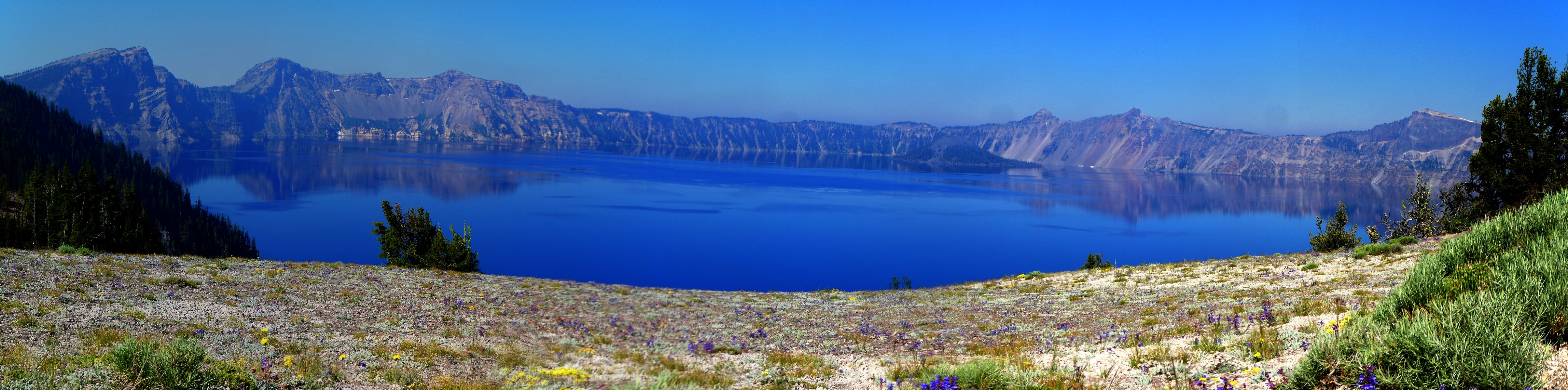
rim of Crater Lake and visit most of the viewpoints. Spectacular, even though the vistas are cluttered and muted by haze from the California border fire. Before I rocket out of the Park, I again see Paul NoHawk and Trish Fire Woman at a Crater Lake overlook. Now this is a fitting pause to the pursuit of the PCT.
     Driving to Burney, the hulk of the ever present Mt Shasta looms in the murk. Ever-present, it was slow getting to Shasta, and now it won't leave the views. Maybe the approach to Washington will be sans Shasta?
     Next day, to Tonopah. As I drift into California, I stop for scenic toilet photos with Mts Lassen and Shasta as the scenic. There's a wistful wind at the vista, prompting fond memories of the Hat Creek Rim
     Stopping at an unscenic toilet not far from the largest ammunition depot in the world (Hawthorne Army Depot, near Hawthorne, NV; it's yuge - at 262 square miles), I open the toilet door and a very aggravated tarantula wasp flies into me, stinging me on the ankle. Amazingly, the sting feels excruciating for a few minutes, then calms and there is no lasting welt or irritation. Certainly, reminiscing about the 2018 Pygmy PCT, Penetrating Oregon - a Mazama Meander is filled with peasantries.

PCT 2018 - Seiad to Crater, Postlog Photos

Click thumbnail to see full size image

PCT-2018-day-post-1 Kyle web.jpg

PCT-2018-day-post-2 Fire Woman, No-Hawk web.jpg

PCT-2018-day-post-3 twinkle web.jpg

PCT-2018-day-post-4 Crater Lk web.jpg

PCT-2018-day-post-5 Crater Lk web.jpg

PCT-2018-day-post-6 goodbye Crater Lk web.jpg

PCT-2018-day-post-7 blue eye web.jpg

PCT-2018-day-post-8 always Shasta web.jpg

PCT-2018-day-post-9 guided by Shasta web.jpg

.

"When we tug at a single thing in nature, we find it attached to the rest of the world". - John Muir

A peek into the rest of Oregon
(Click the image to see the full-size image)

.

The Best Scenic Toilet of the PCT 2018 - Seiad to Crater

Click thumbnail to see full size image

PCT-2018-scenic-toilet10 Soda Mountain Wild web.jpg

PCT-2018-scenic-toilet11 Soda Mountain Wild web.jpg

PCT-2018-scenic-toilet12 Soda Mountain Wild web.jpg

Scenic Toilets of the PCT 2018 - Seiad to Crater

Click thumbnail to see full size image

PCT-2018-scenic-toilet1 Seiad web.jpg

PCT-2018-scenic-toilet2 Klamath web.jpg

PCT-2018-scenic-toilet3 Offenbacher web.jpg

PCT-2018-scenic-toilet4 Offenbacher web.jpg

PCT-2018-scenic-toilet5 Grouse Gap web.jpg

PCT-2018-scenic-toilet6 Crater Lake web.jpg

PCT-2018-scenic-toilet7 Crater Lake web.jpg

PCT-2018-scenic-toilet8 Crater Lake web.jpg

PCT-2018-scenic-toilet9 Hat Creek Rim-way home web.jpg

Muir, may your paths be dirt
(Click the image for the full-size image)

"Going to the mountains is going home". - John Muir

PCT - wilderness areas along the PCT, pdf
PCT - wilderness areas along the PCT, pdf file
(Click the image for the full-size image)

.

.

     *ERM: Energy Required Miles, are there data to support this mileage adjustment?
     Journal of Outdoor Recreation, Education and Leadership
     Petzoldt first proposed his theory in his 1976 book “Teton Trails” to help backpackers plan trips and calculate their energy needs on mountain trails. “Petzoldt defined one energy mile as the energy required to walk one mile on the flat. He recommended adding two energy miles for every 1,000 feet of elevation gain, so a person hiking one mile and 1,000 feet upward would use the equivalent of three energy miles,” Phipps said.
     Petzoldt’s energy mile theory was just a reflection of the mountaineer’s “gut feeling,” Phipps said. The theory had never been tested in a laboratory before the study began in WCU’s Exercise Physiology Laboratory in the spring of 2010, Phipps said.
     To determine the validity of the theory, the study measured the energy cost and perceived exertion for walking on flat ground, with and without a 44.5-pound backpack, and up an elevation gain of 1,000 feet, with and without the backpack, through the collection of metabolic data, Phipps said.
     Twenty-four student, faculty and staff volunteers, including 12 males and 12 females, went through four testing sessions as the research continued into fall semester of 2010. The study results showed that the additional energy cost for ascending 1,000 feet ranged from 1.34 to 2.02 energy mile equivalents, for an average of about 1.6 miles, compared to Petzoldt’s use of two energy miles for each 1,000 feet. The range revealed by the study was due to the “hikers” personal weight differences, Phipps said. “It is remarkable that Petzoldt’s energy mile theory is so close to the actual energy cost measured during our study,” Phipps said. “In the field of outdoor education, it’s important for leaders to include an estimation of energy requirements during the planning of hiking trips.”
     Phipps said the energy required for hiking up steep mountain trails would vary for individuals and groups, and the variables of the trail would also factor in, but he recommends that backpackers stick with Petzoldt’s idea of adding two energy miles for every 1,000 feet of elevation gain when planning trips.
     The Validity of Petzoldt's Energy Mile Theory, 2010
Authors: Maridy McNeff Troy, Maurice L. Phipps
Publication: Journal of Outdoor Recreation, Education, and Leadership

.

.

All WV PCT, JMT, Sierra hike reports:

Click here or on the PCT trail marker to go to all WV reports about The PCT, JMT, Sierra hikes

All Wilderness Vagabond trip reports about the PCT, JMT, Sierra hikes
Looking for All Wilderness Vagabond trip reports about the PCT, JMT, Sierra hikes?
Click the image to go to All WV reports about The PCT, JMT, Sierra hikes

Links and books:

Half-mile site: Pacific Crest Trail Maps and GPS Information - a terrific resource

Pacific Crest Trail Association

Click here to: see the First ascent of El Capitan, Argosy Magazine, 1959 (10 pages) 22 MB.

Marc Reisner (1993) Cadillac Desert: The American West and Its Disappearing Water, Revised Edition, Penguin Books

Bill McKibben – suggested books include: Maybe One, Eaarth, The End of Nature

Maps: (thanks to Halfmile (Lon Cooper) for use of his maps

The waypoints with numbers indicate PCT mileage from the Southern US border.

Maps for Days 1 - 6: for the wonderful Halfmile maps for section R, California, Start - Seiad Valley, CA; mi 1655.9. End - Hwy 5, mile 1718.9 [near Ashland, OR] these maps cover days 1 to 6 of this hike, click here. Fairly large pdf file. Twelve pages of maps and elevation profiles. Visit pctmap.net for waypoints, tracks, more maps -- for the entire PCT. A super resource. Each of these three pdf files is approximately 20 mb (well worth the digital dithering).

Maps for Days 7 - 11: 54.5 miles; section B, Oregon, Hwy 5, mile 1718.9 [near Ashland, OR]; End - Hwy 140, mile 1773.4 [near Fish Lake], click here. Ten pages of maps and elevation profiles. There is no Oregon section A (it is included in California, section R).

Maps for Days 12 - 15: section C, Oregon, 74 miles miles; Start - Hwy 140, mile 1773.4 (near Fish Lake). End - Hwy 138, mile 1847.8 (near Cascade crest). click here. Sixteen pages of maps and elevation profiles.

Related Sites:

Scenic Toilets of Inner Earth: Scenic Scatology of the Wilderness Vagabond

Has Conservatism Lost Its Soul? The Tea Party passions are the rancid emissions of class-based greed disguised with flags and Christian symbols.

We Are Breeding Ourselves to Extinction (click here for full article) or at:

Breeding ourselves to extinction? .

.

     Medicare for All would reduce health care costs and boost wages, according to a new report authored by the Mercatus Center. This is the same think tank known for promoting deregulation and trickle-down economics, and has even received funding from the Koch brothers.
     The report finds that the Sanders Medicare for All proposal would save $2 trillion in overall health care expenditures between 2022 and 2031. That's because 1) The federal government could negotiate lower rates with providers. 2) Administrative costs, marketing budgets, and bloated executive salaries would be reduced.
     So there you have it. The next time you hear conservatives rail against Medicare for All, point them towards research funded by the Koch brothers. What do you think?

health insurance, not health care
we have health insurance, not health care
(Click the image for the full-size image)

.

.

More Truth Than Joke:

Feynman has it
Feynman has it
(Click the image for the full-size image)

common decency
common decency
(Click the image for the full-size image)

97 percent
97 percent
(Click the image for the full-size image)

'merica First
'merica First
(Click the image for the full-size image)

.

"What luck for the rulers that men do not think". - Adolph Hitler
.

America is under attack from the GOP
(Click the image for the full-size image)

commodities are not values
(Click the image for the full-size image)

keep close to nature's heart
(Click the image for the full-size image)

flat Eaarth
flat Eaarth
(Click the image for the full-size image)

tax cut truths
tax cut truths
(Click the image for the full-size image)

freedom from religion
The U.S. was founded on freedom from religion
(Click the image for the full-size image)

no bail
no bail
(Click the image for the full-size image)

Orwell, now
Orwell, now
(Click the image for the full-size image)

we are in the twilight zone
(Click the image for the full-size image)


Wild Vagabond Main   Trip Report Index   Caveat