and Musings about the Life Zones of C. Hart Merriam
Text and photos © copyright by Rob Jones

Co-participants: solo backpack
Total Trail Miles –> 40 miles.
Total ERM = 56.
camera: Panasonic DMC-FS19
| ||||
|
| |||||

|
| |||||
Total Trail Miles –> 40 miles.
Total ERM = 56.
camera: Panasonic DMC-FS19
| ||||
|
| |||||
|
| |||||
| ||||
| ||||
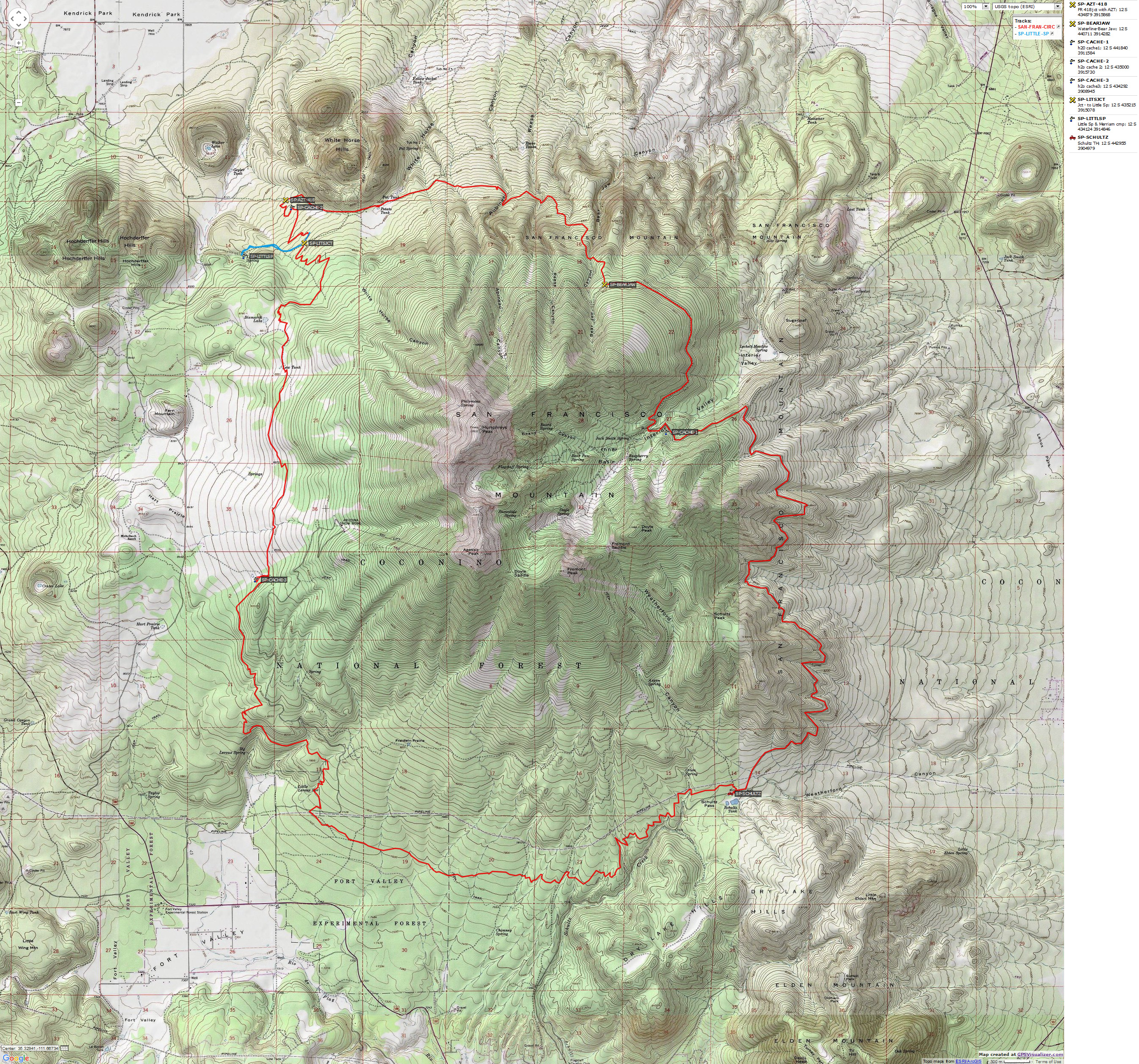
Summary: This is the tale of a four day, three night circumnavigation, a circum-ambulation, around San Francisco Mountain - commonly referred to as the San Francisco Peaks in the Coconino National Forest of Northern Arizona. The trail distance was about 40 miles total, and made use of existing closed roads, trails (including a 19-mile chunk of the Arizona Trail (AZT), a National Scenic Trail), and a short piece of an open forest road. The route included: Starting at Schultz Tank TH, Waterline Road (closed) to the Bear Jaw Trail, Bear Jaw to FR 418, 418 to the AZT, and the AZT back to Schultz Tank.
ERM = Energy Required Miles. A mile is added for
every 500' elevation gain or
loss. It's a very serviceable method of estimating energy required miles. ERM was initially used in Trails
of the Tetons (long out of print) by Paul Petzold, founder of NOLS. It's a wonderfully useful concept and
application. Add one mile for each 500' up AND down to distance = ERM. I use ERMs to calculate what the actual
day is like. It's a very serviceable method of estimating energy required miles. Remember, however, that the
ERMs are estimates because they depend on GPS satellite coverage and math functions.
Using ERMs does not account for the 'texture' of the route or trail - that
is, rocky, boulders, no trail, slimy mud, etc., yet does help approximate the route.

| ||||
for a full-resolution map, click here. Caution - do not use this map or gps track for navigating the route.
Background:
San Francisco Mountain: San Francisco Mountain dominates our
circum-ambulation around this Arizona high point, the only stratovolcano in Arizona. Mt. Rainier is
another stratovolcano, a cone-shaped volcano. Commonly called the San Francisco Peaks, Mt. Humphrey is
the highest point in Arizona. The extruded igneous rock of San Francisco Mountain is composed of layers
of rhyolite and volcanic ash and is in the Eastern part of the San Francisco Volcanic Field, which may
sit above a hot spot stretching from the town of Williams to Sunset Crater Volcano National Monument.
Some 600 mostly cinder cone volcanoes range across the field. Theories involving plate tectonics hold
that the North American plate is moving West above a hot spot in the core, and geologists estimate that
the volcanic field is 6 million years old on the Williams side to the latest eruption at Sunset Crater in
1064 AD. San Francisco Mountain holds a prominent position in the stories and culture of many area
Native American nations and is considered by many to be the preeminent mountain on the Colorado Plateau.
For us, it's a fine center piece for a circum-ambulation.
The AZT, Arizona National Scenic Trail: Flagstaff's own Dale
Shelwalter, a fifth-grade schoolteacher, walked what would become the AZT in 1985, after spending several
years piloting trail sections. The first section of the AZT was dedicated in 1988, starting from the
North Rim of Grand Canyon National Park and running for 54 miles toward Utah. Other segments followed,
and the AZT was officially completed in 2011, 26 years after Dale pioneered the route and one year after
he died. Numerous public land agencies (e.g., the NPS, FS, BLM) and volunteer groups and individuals
made the AZT a reality, starting with Dale's vision. The need for trail and easement work are continuous
along the 800 mile AZT, which travels through almost all C. Hart Merriam's life zones as it rambles from
the Mexico border to Utah.
![]() Right
Click (then save this file: "save link as..." in most browsers) on this Download link to get the GPX file from
my GPS - you can then open it in your mapping software. Note - that's a Right Click on this link.
You will get the track for your software shown in the map above.
Right
Click (then save this file: "save link as..." in most browsers) on this Download link to get the GPX file from
my GPS - you can then open it in your mapping software. Note - that's a Right Click on this link.
You will get the track for your software shown in the map above.
Be sure to check the Arizona Trail Association web site for a current report
about water sources before you go.
San Francisco Circum-ambulation, Prelim Photos


Prelim: placement of water caches.
Driving partly around the Peaks, I hike in water caches off FR 418
(FR is Forest Road), Aspen Corner, and up from Lockett Meadow to the Waterline - Inner Basin junction,
preparing for a three night, four day jaunt through color country. Yes, the Aspen are in full Fall bloom.
I enjoy nearly 5 miles of hiking to prepare for the circumnavigation.
It's growing cold in the high route around San Francisco Mountain, with a
freeze warning issued for the Flagstaff area. It's time to take the heavy, super fluffy sleeping bag.
Now, I'm wondering if the beer that I stashed with the water will freeze, oh no.
 |
 |
 |
 |
 |
 |
 |
 |
 |
 |
 |
 |
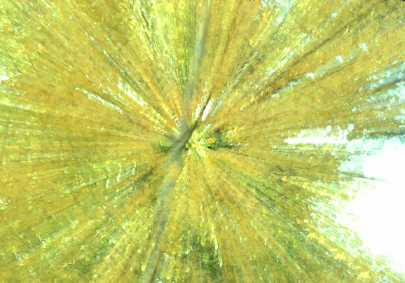
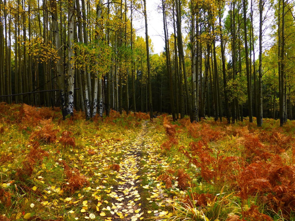
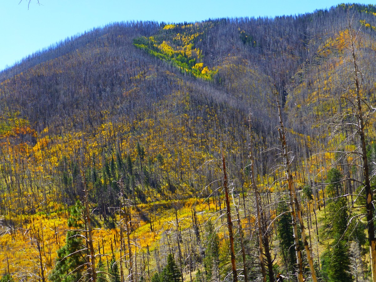
Day 1. Blazing Aspen. To Waterline - Inner Basin junction:
9.4 miles. ERM = 12.4. Camp @ 9400'.
The glowing Aspen form a deluxe foreground to the peaks of San Francisco Mountain,
including Mt. Humphrey, the Arizona high point. What peaks? The Aspen blaze takes visual priority, and little
else is seen.
I've hiked the long ramp of the Waterline Trail into yellow splendor. It's the
(closed) maintenance road to the wells and springs in the Inner Basin that are part of the City of Flagstaff
water supply. And, the first two thirds of today is through the 2010 Schultz Burn, open to the sun and wind,
and not the most scenic part of this adventure. However, one does get a ranging view of the cinder cones of
the Eastern part of the San Francisco Volcanic Field.
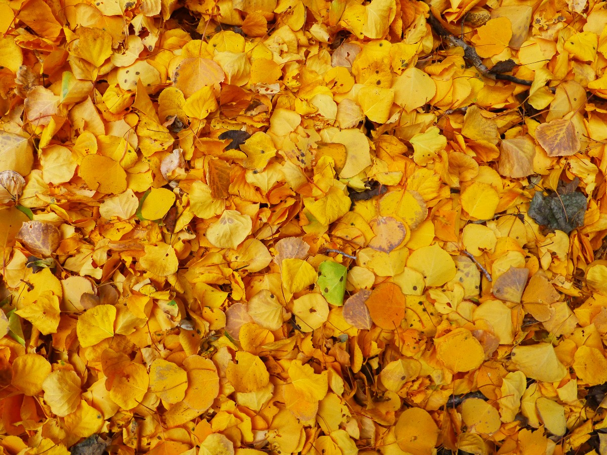
Arriving at the first water cache, I meet a throng of leaf-peepers coming up
from Lockett Meadow, so numerous that there are parking restrictions down below. Yikes. As the afternoon
lengthens, the flow of gawkers slows yet hikes faster. The temperature starts to drop and I seek the last
bits of low-angle sunlight, squeezing the meager heat from the rays. And, the Aspen display continues. It's
time for more feeble attempts to photograph this natural exhibition. Photos just don't capture the splendor
of the golden Aspen. So, I stroll a ways into the Inner Basin.
I find decent camping and an arch of Aspen down the old access road below the
Jack Smith well and the snow survey shack. No camping is permitted in the Inner Basin.
Eric, soon to be working at the Arizona Snow Bowl, arrives to camp from Lockett
Meadow. The crowd dwindles, then disappears, the wind calms and all is well.
The beer is a little cold, given ambient conditions, yet the down jacket over
a few other layers and a wool hat make it quite pleasant.
 |
 |
 |
 |
 |
 |
 |
 |
 |
 |
 |
 |
 |
 |
 |
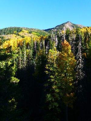
Day 2. Hang Fish. AZT Linkage. To the Arizona Trail:
9 miles. ERM = 16. Camp @ 8400'
The rain zips horizontally over tiny Potato Tank, propelled by a
leaf-stripping wind. I'm hiding behind a row of Ponderosa Pines, attempting to avoid the worst of the rain.
The storm subsides some, yet appears long term, so I start out again in what is now a drizzle.
It is a cool start this morning, and I can see my breath when the
penetrating wind pauses. Clouds obscure the yellow ramp leading up to Fremont Peak and generally make a
nuisance of themselves all day.
My four clothing layers at the start of today's hiking are down to two by
the time I've hiked the three miles to the Waterline-Bear Jaw junction at 9700'. Windrows of bright yellow
Aspen leaves border the trail as I head toward the Abineau-Bear Jaw trailhead. I meet Jen and Rick, who
are hiking this loop.
I snack under a stately Ponderosa as the first sprinkles arrive. The main
storm today cranks in during the 2.5 mile road walk on FR 418 to where the circumnavigation route joins
the Arizona Trail, AZT.
From here, it's not far to water cache #2, where I speedily set up
camp - thinking another storm pulse will soon arrive. Looking for a camp spot, I see a hand winch
screwed to a tree with a cable running from the winch through the trees. Following along below the cable,
I find a barrel decorated as a fish suspended high in a tree. Hang fish. Most curious. I later learn
that this is a geocache, and a superbly constructed and hidden one too.
It never warms, as pulses of wind and dark clouds fly along the AZT. So,
I eat dinner and slide into the fluffy bag. I'll make more journal notes from there, and enjoy a prolonged
examination of my eye lids.
 |
 |
 |
 |
 |
 |
 |
 |
 |
Day 3. Elk Utterances and stormy squalls. Hypothermia City?
To Alfa Fia Tank and water cache #3:
7 miles, ERM = 11. Camp @ 8750'.
The raw rain thunders between the trees, driven by a 30 MPH cold wind.
I'm hiding beneath an angled fir, using my umbrella as a shield from the stream of rain coursing around
the trunk and driven between the trees. Still, I'm getting leakage off the pack cover and down my leg, and
I'm becoming more and more wet. Yikes - it's hypothermia city on the AZT.
The day starts with the utterances of Elk. Low volume talking, not the
riveting, haunting bugling of bulls, yet more the chit chat of cows and this year's youngsters.
At morning, the sky dribble continues intermittently. And I wait awhile,
thinking that the sun will show itself. Miraculously it does during morning cocoa, then more dribble hurries
me to get on the trail, where I successfully brandish the trusty umbrella. The stroll through the dark forest
is lovely until the pounding sets in. I would be OK if not for the horizontal nature of the rain when I
leave the dense tree cover and enter the edge of the meadows near Bismark Lake.
Back on the trail after the horizontal pummeling, I'm galloping along at full
walking speed, wanting to get into the TarpTent before the next onslaught, and to warm up too.
I meet the only hiker of the day, anxiously walking along in a shirt and
carrying a water bottle. "I need help," he reports, "I've lost the trail and I don't want to hike to Mexico."
He had walked in via the Aspen Trail, and missed the turn of the loop, yet noticed the AZT signs designating
the mileage to Mexico, to Utah. A few questions and a bit of redirection and he heads off toward the trailhead
and I continue to gallop along the AZT toward where warm fingers reign.
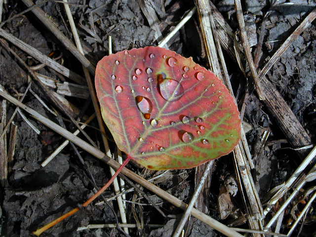
Amazingly, this time the rain holds until I reach the Alfa Fia Tank area and set
up camp. After I finish warming in the fluffy bag, I venture out to explore this Aspen dotted corner of Hart's
Prairie. Delightful. The colors are rich and I determine that one could use the tank as a water source if
needed (assuming the water is treated prior to use).
I'd have a good photo of the Peaks, but for the cloud bank, which smothers
everything above about 10,000 feet. Perhaps the clouds will act like a lid tonight, preventing heat loss?
Those clouds might be good for something after all. Later, I learn that it's snowing at about the 11,000 foot
level of the Peaks. Yikes.
I'd planned a modest day today so that I could search for and investigate
Little Spring and the C. Hart Merriam Base Camp historic site. Yet, the hypothermic conditions prompted me
to head straight for the next planned camp. I returned on a separate day hike and located the spring and
base camp (see the map and the subsection of this report).
 |
 |
 |
Day 4. All Quiet on The AZT. Obnubilation.
To Schultz Tank Trailhead, completing the circum-ambulation:
12.5 miles, ERM = 16.5. Total miles (from GPS) = 38 + 2 to Merriam's Base Camp. Total ERM = 56.
Possible water sources for self-contained hikers:
If the tank water is turbid, you may need to use alum and a collapsible
bucket to clarify the water prior to treating it.
A summary about how to use alum to clarify water prior to treating it can be found here.
Getting there, circum-ambulation:
The clouds, I'm walking in the clouds capping the San Francisco Peaks.
Mystically foggy. Obnubilation - "darken, dim, to cover as with a cloud" says the dictionary. The
medical dictionary talks about mental cloudiness and torpidity. The primary definition reigns today,
not the way politicians obnubilate issues through talking points that obscure the truth. It's a dark start.
Yet, my mind is clear and walking through the clouds adds a mystical, meditational component to the
circum-ambulation. It is quiet, it rains some but not hard. I don't see anyone until I'm back at Schultz Tank.
All quiet on the AZT, indeed.
Driving home, the clouds part briefly and I see snow on the Peaks. It's
been a somewhat chilly circum-ambulation of the San Francisco Peaks.
listed for a counter-clockwise loop starting at Schultz Tank; none are perennial:
1. spigot at Jack Smith Spring - junction of Waterline and Inner Basin Trail (check with Flagstaff Water Department, springs in Inner Basin are captured and not available to hikers).
2. Potato Tank along FR 418
3. Little Spring - 1.5 trail miles South of FR 418 and West 0.8 miles from the AZT, near C. Hart Merriam Base Camp (historic; see map).
4. Alfa Fia Tank (off Aspen Corner area)
5. Schultz Tank
I started and ended at Schultz Tank TH.
From Flagstaff – Take route 180 Northwest, toward the Grand Canyon,
away from town. At about 0.2 of a mile south of mile marker 219, turn right (North) onto Schultz Pass
Road (also known as FR 420). Follow FR 420 for about five bumpy miles, and on your right you will see
a parking area and signs for the Arizona Trail. Walk back to the road from which you entered the parking
area and then East on it for about 0.1 mile, turn North onto the Waterline Road, which is soon closed to
vehicles by a metal gate.
 |
 |
 |
One can day hike to the C. Hart Merriam Base Camp at Little Spring. It's a
short jaunt of less than a mile from the Arizona Trail, not far from where it crosses Forest Road 418, yet
large in the science realm. Merriam reported about his journey to Little Springs, "After spending three days
in outfitting (at Flagstaff), we proceeded to Little Spring, at the north base of San Francisco Mountain, and
pitched our tents in a grove of aspens and pines, on a knoll just northwest of the spring, at an altitude of
2,500 meters (8,250 feet). This was our base camp for two months (August and September 1889), and from it
numerous side-trips were made into the surrounding country."
As scientists and area nature lovers know, Dr. Clinton Hart Merriam, America's
first bio-ecologist, established the Life Zone concept in 1889 on the San Francisco Mountain of Arizona. When
he was sixteen years old, Merriam accompanied the 1872 Hayden Survey to Yellowstone, and was the founder and
first chief of the U.S. Bureau of Biological Survey, now the Fish and Wildlife Service. Merriam was the first
to advance and define the Life Zone concept in scientific terms. In his report on the San Francisco Mountain
region (1890) he concluded that forms of life are dependent upon altitude zones, and the designation of a
region or zone by the presence of animals and plants not found in other zones. Because temperatures on North
slopes differ from those with Southern exposure, life zones do not run on arbitrary contours. Latitude, the
distance from the equator, is also important in determining climate. This combination of altitude, exposure,
and latitude (climate) is basic in the ecology that governs the existing distribution of plants and animal
indigenous to the various regions.
Merriam's concept was fundamental in the development of the science of ecology,
and is one of the most important modern generalizations in biology. As America's first bio-ecologist, Merriam
ranks in the top tier of American scientists. His "laws of temperature" establishing life zones and life
distribution were fundamental to the Life Zone concept.
Merriam divided the region into seven "life zones" because of differences
in their biology (resident plants and animals). Merriam's premise was that temperature was the largest
controlling factor in these life zones. Starting from the top of San Francisco Mountain to the lower Painted
Desert, he named these zones: (1) Alpine, (2) Sub-alpine, (3) Hudsonian or Spruce, (4) Canadian, (5) Neutral
or Pine, (6) Pińon, and (7) Desert.
The Merriam (wild) Turkey and the Merriam Elk (now extinct - due to livestock
overgrazing and market hunting) were named for him, Clinton Hart Merriam. Rocky Mountain Elk were introduced
in Northern Arizona in 1913 from Yellowstone National Park and are the Elk you see today when wandering around
San Francisco Mountain.
From the NAU website I learned that the Merriam-Powell Center for Environmental
Research at NAU is helping to create the scientific knowledge and understanding needed to address significant
environmental challenges, including climate change and biodiversity loss. C. Hart would be troubled by our
inadequate response to climate change, yet a happy scientist that others are pursuing the generalizations he
formed while working out of the Merriam Base Camp along what is now the Arizona Trail.
Getting there, day hike to the C. Hart Merriam Base Camp:
Driving Northwest from Flagstaff, follow hwy 180 toward the Grand Canyon.
At 0.2 of a mile North of mile marker 235, turn right (East) onto FR 151. Follow FR 151 for 1.6 miles,
then turn left onto FR 418 and drive 1.1 miles, where you will see the carsonite AZT signs on both sides
of the road. Hike South on the AZT for 1.5 miles. The AZT crosses an abandoned forest road, one of many so
log your distance. Hike 0.8 miles West down this road, stepping over several down trees to Little Spring
and the Base Camp. You'll see a high fence around the spring area. If you have the ATZ smartphone app, enable
your phone GPS and you can see where the (unmarked) turn is to Little Spring, and where it is on the map.
If you use a GPS and/or know how to read a topo map - look in the upper right
hand margin outside the map posted above and you will see GPS coordinates for the turn to Little Spring off
the AZT, and a waypoint for Little Spring. These UTM data use NAD27 datum.
This is arguably one of the most gorgeous sections of the AZT, and you may
want to extend your hike along the AZT to Bismark Lake or to Aspen Corner. See the Arizona Trail Association
(http://www.aztrail.org/) for a smartphone app that is free for the ATZ section of this trip (you can find
it on google play).
| ||||
*ERM: Energy Required Miles, are there data to support this
mileage adjustment?
Journal of Outdoor Recreation, Education and Leadership
Petzoldt first proposed his theory in his 1976 book “Teton Trails” to
help backpackers plan trips and calculate their energy needs on mountain trails. “Petzoldt defined one
energy mile as the energy required to walk one mile on the flat. He recommended adding two energy miles
for every 1,000 feet of elevation gain, so a person hiking one mile and 1,000 feet upward would use the
equivalent of three energy miles,” Phipps said.
Petzoldt’s energy mile theory was just a reflection of the mountaineer’s
“gut feeling,” Phipps said. The theory had never been tested in a laboratory before the study began in WCU’s
Exercise Physiology Laboratory in the spring of 2010, Phipps said.
To determine the validity of the theory, the study measured the energy cost
and perceived exertion for walking on flat ground, with and without a 44.5-pound backpack, and up an elevation
gain of 1,000 feet, with and without the backpack, through the collection of metabolic data, Phipps said.
Twenty-four student, faculty and staff volunteers, including 12 males and 12
females, went through four testing sessions as the research continued into fall semester of 2010. The study
results showed that the additional energy cost for ascending 1,000 feet ranged from 1.34 to 2.02 energy mile
equivalents, for an average of about 1.6 miles, compared to Petzoldt’s use of two energy miles for each 1,000
feet. The range revealed by the study was due to the “hikers” personal weight differences, Phipps said.
“It is remarkable that Petzoldt’s energy mile theory is so close to the actual energy cost measured during our
study,” Phipps said. “In the field of outdoor education, it’s important for leaders to include an estimation
of energy requirements during the planning of hiking trips.”
Phipps said the energy required for hiking up steep mountain trails would vary
for individuals and groups, and the variables of the trail would also factor in, but he recommends that
backpackers stick with Petzoldt’s idea of adding two energy miles for every 1,000 feet of elevation gain when
planning trips.
The Validity of Petzoldt's Energy Mile Theory, 2010
Authors: Maridy McNeff Troy, Maurice L. Phipps
Publication: Journal of Outdoor Recreation, Education, and Leadership
Arizona Trail Association - trail and water conditions; maps of some of this hike
A summary about how to use alum to clarify water prior to treating it can be found here.
Bill McKibben – suggested books include: Maybe One, Eaarth, The End of Nature
| ||||
for a full-resolution map, click here. Caution - do not use this map or gps track for navigating the route.
Scenic Toilets of Inner Earth: Scenic Scatology of the Wilderness Vagabond
We Are Breeding Ourselves to Extinction (click here for full article, pdf)
More Truth Than Joke:
| ||||
| ||||
| ||||
| ||||
| ||||
| ||||
|
Wild Vagabond Main |
Trip Report Index  |
Caveat  |
|---|


