Mazatzal Meandering
Baby Doll TH to The East Verde River,
along bits of the Arizona Trail, looping back on the Mazatzal Divide Trail
(about 37 miles; ERM = 63)
April 1 - 6, 2014
Text and photos
© copyright by Rob Jones
 |
Co-participants: Dave Rumbellow & Rob
Total Trail Miles –> 37 miles.
Total ERM = 63.
camera: Panasonic DMC-FZ200

|
|---|
Lupine - Day 2
(Click the image for the full-size image)
|
|---|
|

|
|---|
East Verde Crossing - Day 2
(Click the image for the full-size image)
|
|---|
|

|
|---|
Movie - East Verde Crossing - Day 2 - 7.9 MB
(Click the image to see the short video)
|
|---|
|
"Between every two pines is a doorway to a
new world". - John Muir
Prelim:
I had scored a long backpack permit for Grand Canyon NP, yet my podiatrist
said "Well, you might want to reconsider - if you have trouble down there (plantar fasciitis) you will be a very
long way from help." Drat. Simultaneously, Dave called and said "What about the Mazatzals, what do you know
about this wilderness?" Nothing. So, we made plans to explore the Mazatzal Wilderness.
ERM = Energy Required Miles. A mile is added for
every 500' elevation gain or
loss. It's a very serviceable method of estimating energy required miles. ERM was initially used in Trails
of the Tetons (long out of print) by Paul Petzold, founder of NOLS. It's a wonderfully useful concept and
application. Add one mile for each 500' up AND down to distance = ERM. I use ERMs to calculate what the actual
day is like. It's a very serviceable method of estimating energy required miles. Remember, however, that the
ERMs are estimates because they depend on GPS satellite coverage and math functions.
Using ERMs does not account for the 'texture' of the route or trail - that
is, rocky, boulders, no trail, slimy mud, etc., yet does help approximate the route.


|
|---|
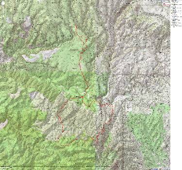
Map - Mazatzal loop, 37 miles
(Click the image to see the map)
|
|---|
|
for a full-resolution map, click here. Caution - do not use this map or gps track for
navigating the route.
Right
Click (then save this file: "save link as..." in most browsers) on this Download link to get the GPX file from
my GPS - you can then open it in your mapping software. Note - that's a Right Click on this link.
You will get the track for your software shown in the map above.
Day 1 photos - Mazatzal Wilderness 2014
Day 1: Doll Baby at the Boardinghouse.
To Boardinghouse Canyon:
3.2 miles; ERM = 7; camp@ 3520'.
"No water anywhere in the wilderness" we were told during calls to the Tonto
NF (National Forest) while attempting to find out conditions in the Mazatzal Wilderness. The same happens
when we visit the NF office in Payson. A volunteer wanted to send us up (to near 7,000') to the Highline
Trail, telling us that there was water there, not in the Mazatzal Wilderness. Frustrated after our buffeting
ride to Payson, we are eating lunch outside the FS office when a young woman in carhart jeans strides past.
"Chelsea?" we ask. Yes! It's the wilderness girl, who tells us about trails and water and recommends a
lower route because of cold weather, possible high elevation snow on the way. (We had planned to hike the
Barnhart-Chilson loop.) Eliza from Oregon drives past and returns to join us - she's here to hunt flowers.
We swap stories of wilderness enjoyed and discuss some details before heading for the TH.
After driving to Doll Baby TH, we pack up amidst huge gusts of wind and
lately get on the trail, which is a private ranch road. (We later learn we could have hiked along the River
because the water level was low.) Even with both hat straps tightened, I lose my hat and run after it.
Seeing water at Boardinghouse, we opt to camp so we can do so somewhat leisurely, and I find a spot out
of the wind and where we have a glimpse of the brush-covered Mazatzal Range. Volcanic here. Lots of up
and down along this old road today.
Day 2 photos - Mazatzal Wilderness 2014
Day 2: Green Moss at Whiterock. To White Rock Spring:
6.2 miles; ERM = 9.5; camp @ 4400'.
The rain is popping off the TarpTent, and Dave and I are awaiting a
weather break to cook dinner. Cold air floods in from the South on high winds. A copse of junipers
protects us from the main blast. Probably, there is snow on high.
We start from Boardinghouse camp and soon we are directed off the
road and onto the Arizona Trail, leading us around the LF Ranch, an old homestead that is the reason
for the road. Then, the crossing of the East Verde River. 440 to Mexico and 360 miles to Utah, say
the signs on either side of the river. We cross on rocks as the Verde trickles along between deep pools.
Clear and lovely. Yet, hardly deserving of the moniker "creek" in Idaho or another better-watered state.
At least today. The River bed says there is sometimes a big flow.
Polk Spring/Rock Creek spews crystal water into the Verde as we start
the climb to Polles Mesa, where we find a tiny moss-infested White Rock Spring. After straining water
through a window screen (left at the spring by the trail steward?), we set camp and walk up to Whiterock
Mesa, where we see what appears to be a pueblo or pit house foundation. (Not part of mileage for the day.)
At the spring, we encounter Clutch, who is hiking the AZ Trail, reporting that he is ahead of Sirena, an
AZ Trail ambassador, who is hiking for support of the trail. Of course, Sirena is holding meetings along
the way, and hiking with volunteers on some sections, so one should not expect a blazing pace.
Returning to camp, it starts to rain. I cook in the tiny vestibule of
my tent. A pause. Then hail. Getting out of the tent, distant gloomy slopes look white. Hooray for
the fluffy Marmot bag.
Day 3 photos - Mazatzal Wilderness 2014
Day 3: Ruin Quest. To Whiterock Mesa:
7.2 miles; ERM = 9.7; return to Day 2 camp.
Fantastical shapes are eroded from the old limestone, exposed
to occasional rains for eons. The terrain turns to basalt and still there is no discernable ruins
on our ruin quest. Perhaps a pit house? Lines forming foundations we saw last night? It's a
sticky gambit, accompanied by cat claw and other gription plants. Lots of brush and junipers and
occasional pinyon - perhaps obscures the quest.
Don't follow the GPS track for today.
Returning to camp, it's time for a bucket bath in the breeze. Another
front seems to be arriving - or, perhaps it's departing. So far, it's been quiet. We've seen only
Clutch. Later, we see Moon Gazer and Cookie, on a segment hike from Mt. Peeley to Twin Buttes TH.
They had stayed at the LF Ranch last night, which has a bunkhouse and dinner available for hikers.
I believe one gets the info from the AZ Trail.org group about how to set-up this break from the trail.
Day 4: Verde Return. To Verde - Rock Creek Junction:
3.9 miles; ERM = 6; camp @ 3350'.
Crystal water burbles from Polk Spring, flowing through red speckled
gravel beneath Sycamore and Cottonwood towers, where the flow is topped by green duckweed. Tiny fish
cruise to the spring origin. Polk Spring. A terrific place for a leisurely lunch. Below, haggard
remnants of an orchard are lined like tombstones to Iraq, Afghanistan, other bushco squanderings,
such a waste of lives and treasury. Sad. To say that conservatives want to conserve is an apocryphal
story based on lies based on mistruths and fabrications. What conservatives want to preserve is their
selfish entitlement to repeat lies and reap benefits from doing so.
Then, we walk the short distance to the East Verde River and go
in search of where Boardinghouse Creek meets the Verde. It does not. Probably, it's sucked dry
by the LF Ranch. We note the wondrous water spurting down Rock Creek and camp near where it meets
the Verde. A Kingfisher undulates past. Three horses and a donkey visit from the other side for a
drink while we filter Rock Creek water.
Day 5 photos - Mazatzal Wilderness 2014
Day 5: Hill Country. To near Knob Mountain:
9.9 miles; ERM = 19; camp @ 5600'.
Before it's decent morning - Shrieks from crepuscular peacocks and
peafowl dot the noise pollution from the ranch pump - which drones into the peace about 4 a.m. Then,
dogs argue with coyotes. Moo cows and a donkey low into the gloom. Only the horse are quiet in this
noise menagerie, it seems.
Red quartzite paves and lumps the trail. Up. Up, finally out of the
burned area (Willow Fire of 2004) and over 6,000', we're rounding East and then down, with my plantar
fasciitis flaring and screaming "Stop!" Water-pockets in the drainage - the first water we've seen
since leaving the East Verde. Yahoo. There was dust at Brush Spring.
It's been a long and steep march up from the bottomlands. We find a
passable camp near water and camp. Ian, through-hiking the AZ Trail, comes strolling and tells us of
excellent water and camping just up the trail. Dave and I decide we're comfy enough. It's a hot water
bottle night as temps plummet after sunset.
Tonight, night 5, I'm anticipating natural quiet. It will be a huge
contrast to the morning's agrarian cacophony.
Day 6 photos - Mazatzal Wilderness 2014
Day 6: Downhill Day. To Doll Baby TH:
7.8 miles; ERM = 12.
We're climbing through Ponderosa toward Knob Mountain, passing the
last growing stagnant pools. Quiet and sylvan, remembrances of what the Mazatzals might have been
prior to the 2004 Willow Fire. With global warming and concomitant now-normal drought, it's unlikely
we'll see Ponderosas repopulating the area. Populating! The major factor in climate change - overpopulation.
Overpopulation by people, greed, oligarchy. Bad news for the future and present Eaarth. (Eaarch is a
Bill McKibben spelling,
denoting that earth has been changed by overpopulation and greed to the point it is unrecognizable, so it
needs a new spelling, Eaarth.)
A fast quick climb and we're at the junction of the Mazatzal Divide Trail
23 and the 262 Red Hills Trail (and now, a segment of the AZ Trail). Exploring along the 23 a short distance
- we see that the red cliffs are formed by some sort of conglomerate (? a volcanic conglomerate, a breccia?).
Back at the packs, we start the long slithering drop toward City Creek TH, planning to take the abandoned
route above Brush Hollow to the LF Ranch Rd. Not in the right place on the map? Need a more detailed map?
Anyway, we miss the route and instead cut cross-country near the wilderness boundary, navigating by dead
reckoning. The "wait a minute" and other gription klingons make for tough going, shredding some skin too.
We arrive near the TH, admitting that the mile walk between THs would have been easier, albeit less fun.
Two route notes: go along the River as soon as you enter the gate from Doll
Baby TH (unless the River is high), and walk the road between THs at the end of the hike.
After a quick rinse at the car, we head home, chatting about meandering
the Mazatzal Wilderness.

*ERM: Energy Required Miles, are there data to support this
mileage adjustment?
Journal of Outdoor Recreation, Education and Leadership
Petzoldt first proposed his theory in his 1976 book “Teton Trails” to
help backpackers plan trips and calculate their energy needs on mountain trails. “Petzoldt defined one
energy mile as the energy required to walk one mile on the flat. He recommended adding two energy miles
for every 1,000 feet of elevation gain, so a person hiking one mile and 1,000 feet upward would use the
equivalent of three energy miles,” Phipps said.
Petzoldt’s energy mile theory was just a reflection of the mountaineer’s
“gut feeling,” Phipps said. The theory had never been tested in a laboratory before the study began in WCU’s
Exercise Physiology Laboratory in the spring of 2010, Phipps said.
To determine the validity of the theory, the study measured the energy cost
and perceived exertion for walking on flat ground, with and without a 44.5-pound backpack, and up an elevation
gain of 1,000 feet, with and without the backpack, through the collection of metabolic data, Phipps said.
Twenty-four student, faculty and staff volunteers, including 12 males and 12
females, went through four testing sessions as the research continued into fall semester of 2010. The study
results showed that the additional energy cost for ascending 1,000 feet ranged from 1.34 to 2.02 energy mile
equivalents, for an average of about 1.6 miles, compared to Petzoldt’s use of two energy miles for each 1,000
feet. The range revealed by the study was due to the “hikers” personal weight differences, Phipps said.
“It is remarkable that Petzoldt’s energy mile theory is so close to the actual energy cost measured during our
study,” Phipps said. “In the field of outdoor education, it’s important for leaders to include an estimation
of energy requirements during the planning of hiking trips.”
Phipps said the energy required for hiking up steep mountain trails would vary
for individuals and groups, and the variables of the trail would also factor in, but he recommends that
backpackers stick with Petzoldt’s idea of adding two energy miles for every 1,000 feet of elevation gain when
planning trips.
The Validity of Petzoldt's Energy Mile Theory, 2010
Authors: Maridy McNeff Troy, Maurice L. Phipps
Publication: Journal of Outdoor Recreation, Education, and Leadership
Links and books:
Arizona Trail Association - trail and water conditions; maps of some of this hike
Bill McKibben – suggested books include: Maybe One, Eaarth, The End of Nature
Maps:
|
|
|---|
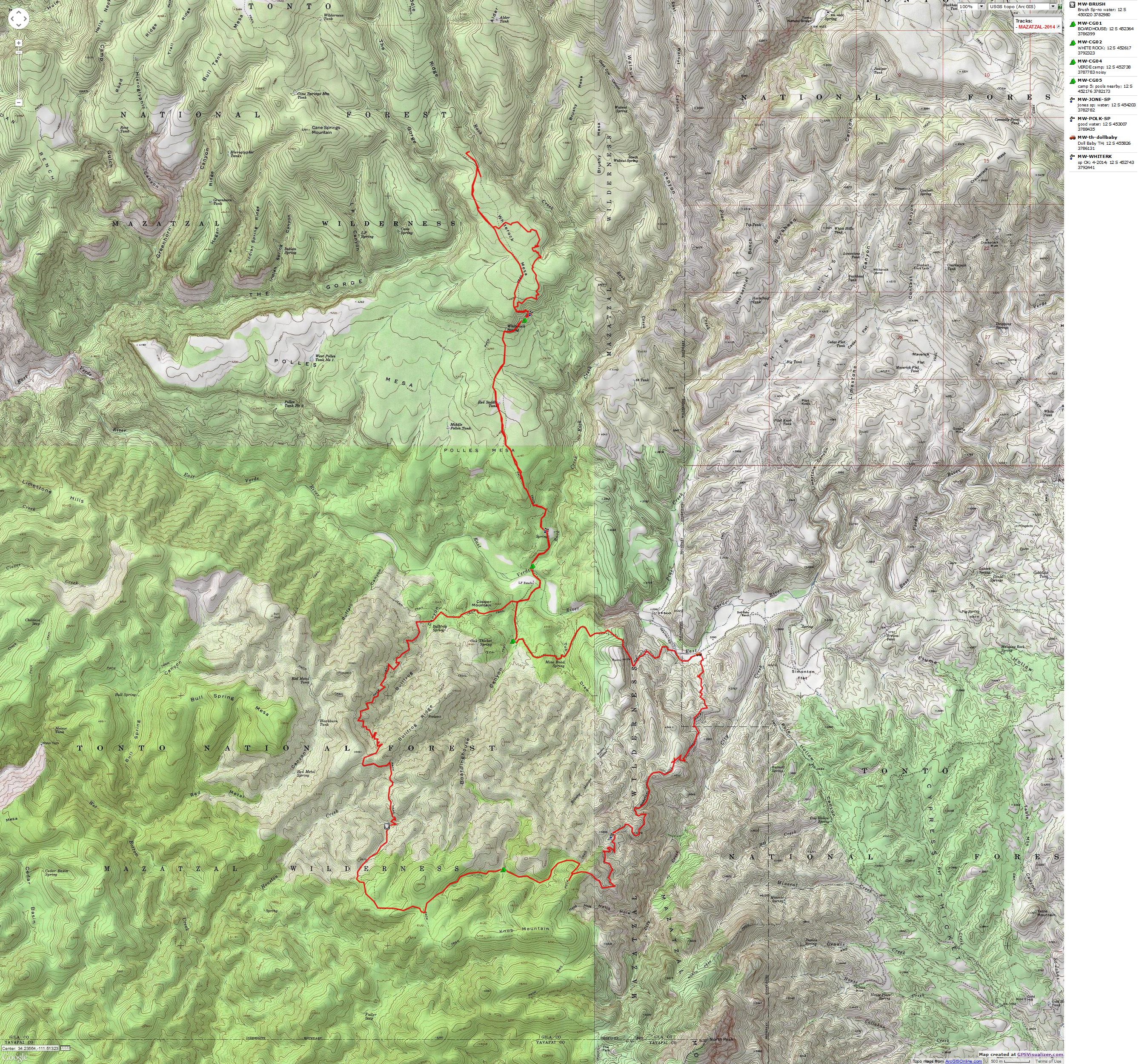
Map - Mazatzal loop, 37 miles
(Click the image to see the map)
|
|---|
|
for a full-resolution map, click here. Caution - do not use this map or gps track for
navigating the route.
Right
Click (then save this file: "save link as..." in most browsers) on this Download link to get the GPX file from
my GPS - you can then open it in your mapping software. Note - that's a Right Click on this link.
You will get the track for your software shown in the map above.
Related Sites:
Scenic Toilets of Inner Earth:
Scenic Scatology of the Wilderness Vagabond
We Are Breeding Ourselves to Extinction (click here for full article, pdf)
More Truth Than Joke:

|
|---|
gop created the debt - now whines about it
(Click the image for the full-size image)
|
|---|
|

|
|---|
gop version of fair and balanced
(Click the image for the full-size image)
|
|---|
|

|
|---|
corporate greed
(Click the image for the full-size image)
|
|---|
|

|
|---|
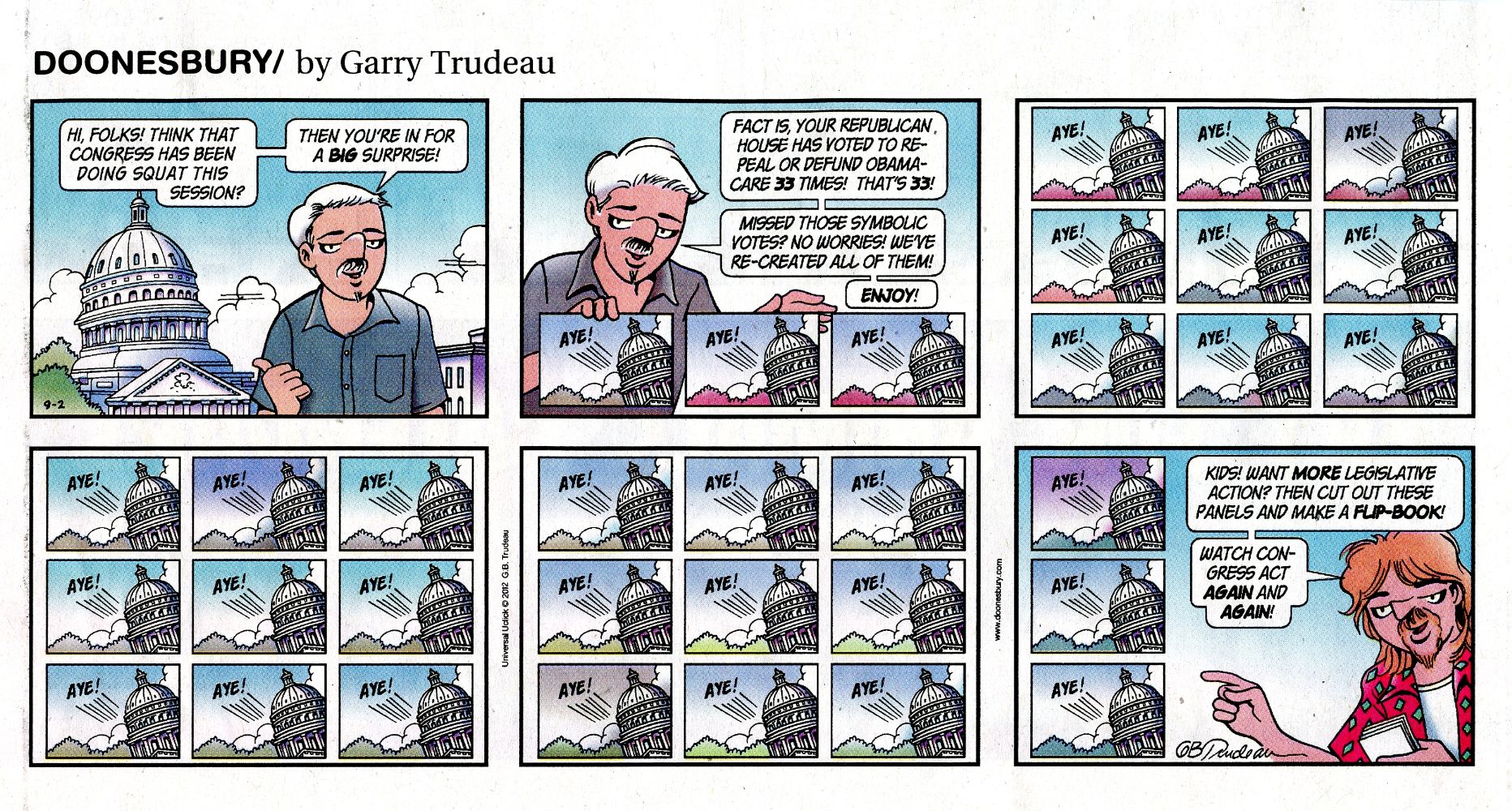
gop wastes legislative time, so much for jobs
(Click the image for the answer)
|
|---|
|

|
|---|
capitalism sucks - benefits the rich
(Click the image for the full-size image)
|
|---|
|

|
|---|
faux news hates jesus
(Click the image for the full-size image)
|
|---|
|
"What luck for the rulers that
men do not think". - Adolph Hitler

|
|---|
50 shades of hay
(Click the image for the full-size image)
|
|---|
|


