Mount Peeley TH to Doll Baby TH
Text and photos © copyright by Rob Jones

Co-participants: Wendy Lotze & Rob
Total Trail Miles –> 42.3 miles.
Total ERM = 72.
camera: Panasonic DMC-FS19
|
| |||||


|
| |||||
Total Trail Miles –> 42.3 miles.
Total ERM = 72.
camera: Panasonic DMC-FS19
|
| |||||
|
| |||||
| ||||
Prelim:
Wendy and I had scored a long backpack permit for the Gems section of
Grand Canyon NP, yet I was recovering from being ill. Thankfully, Wendy had been contemplating hiking part of
the GET (Grand Enchantment), and working on section hiking the AZT (Arizona Trail).
So, we made plans to explore the Mazatzal Wilderness. Wonderful.
ERM = Energy Required Miles. A mile is added for
every 500' elevation gain or
loss. It's a very serviceable method of estimating energy required miles. ERM was initially used in Trails
of the Tetons (long out of print) by Paul Petzold, founder of NOLS. It's a wonderfully useful concept and
application. Add one mile for each 500' up AND down to distance = ERM. I use ERMs to calculate what the actual
day is like. It's a very serviceable method of estimating energy required miles. Remember, however, that the
ERMs are estimates because they depend on GPS satellite coverage and math functions.
Using ERMs does not account for the 'texture' of the route or trail - that
is, rocky, boulders, no trail, slimy mud, etc., yet does help approximate the route.

| ||||
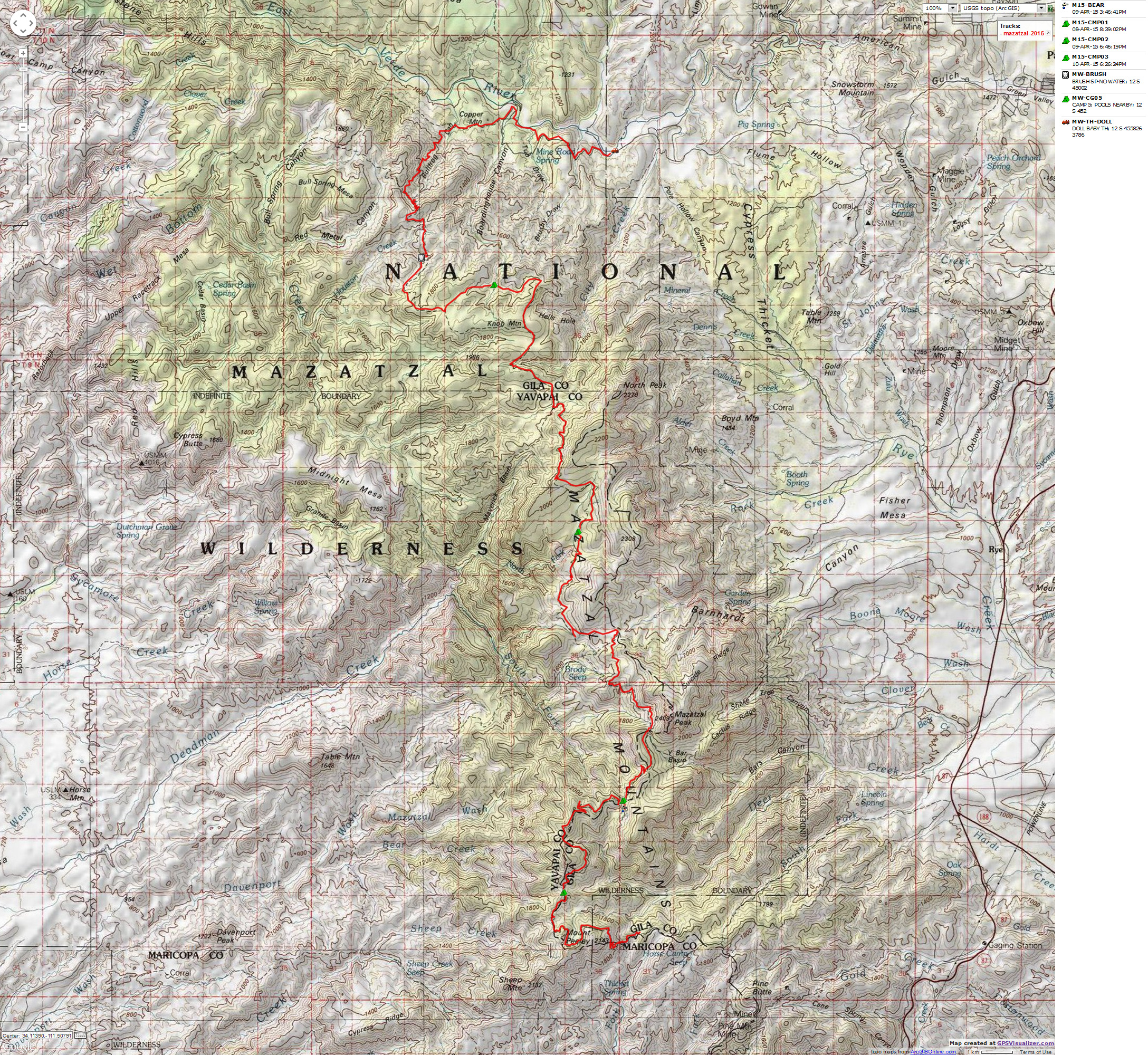
for a full-resolution map, click here. Caution - do not use this map or gps track for navigating the route.
Background:
Day 1. Switching Back:
4.76 miles. ERM = 8. camp @ 6400'.
![]() Right
Click (then save this file: "save link as..." in most browsers) on this Download link to get the GPX file from
my GPS - you can then open it in your mapping software. Note - that's a Right Click on this link.
You will get the track for your software shown in the map above.
Right
Click (then save this file: "save link as..." in most browsers) on this Download link to get the GPX file from
my GPS - you can then open it in your mapping software. Note - that's a Right Click on this link.
You will get the track for your software shown in the map above.
The Mazatzal Mountains are geographically the center of Arizona.
The Mazatzal Wilderness area embraces the north end of the Mazatzal Range, an area of rough desert mountains.
Our section, which comprises Passages 23 & 24 of the Arizona Trail, ends near the East Verde River, the only
designated Wild & Scenic River in Arizona. There is considerable elevation change along our route, from nearly
7200' in passes near Mazatzal Peak to around 3,000' near the East Verde.
The origin of the name Mazatzal is unclear, with some reporting that it is
derived from an Aztec word "Mah-zaht-zahle," meaning "Land of the Deer." The locals pronounce it "Ma-ta-ZEL."
Much of the area through which the Mazatzal Divide trail passes is a bedrock of boot-gnashing Mazatzal Red Quartzite.
Be sure to check the Arizona Trail Association web site for a current report
about water sources before you go. Also, check with the Payson FS office (928-474-7900) about trail and road
conditions. Because of water scarcity, early Spring (March and April) are good times to hike these sky islands.
If you wish to stay at the LF Ranch, email Mary Ann far in advance. I paid $35 for dinner, a shower, and a bunk
in the bunkhouse. Western true tales are for those Mary Ann takes a shine to.
Switching back yet again, Wendy and I are plugging up the Mt. Peeley - Arizona
Trail towards the sky islands called the Mazatzal. Mid-morning we meet Joe at the Doll Baby TH, and Joe,
Trail Stewart for the Peeley section gives us a ride to the TH. Wonderful - thanks Joe! Two other Arizona
Trail volunteers are working on trail signs at the TH, John and Shawn. We all enjoy lunch before Joe scabbards
his Komatsu saw and gallops up the trail, in search of more downed trees, prevalent since the 2004 wide-ranging
Willow Fire produced a prodigious bounty of ghost trees. Wendy and I follow along, gaining altitude and rolling
in and out of luscious shade provided by remaining stands of Ponderosa. What an even more amazing place this was
when these pockets of Ponderosa, the greater coverage by the Pygmy Forest (Pinyon Pine and Juniper) were more
prevalent. Given our headlong race into global warming, we, and perhaps no one will again see forests in the
Mazatzal.
We've switched into hiker mode by the time we settle into the 4+ mile camp
and the air cools drastically, while the wind races just overhead.
Mango Tango eases the flow into a very cool night. It's an evening for hot
water bottles and wool hats.
Day 1 photos from the AZT


Day 2. Bearly There. To Bear Spring:
5.2 miles. ERM = 8. Camp @ 6400'.
Around the bump and into the saddle we tromp, seeing an attractive
swatch of country with living pines and Alligator Juniper, below, in the saddle. A promise of nearby
water. Sun and shade and a place to call home for the evening. It does feel like home to us.
Sure, it's a short day, yet the prospect of the next water is distant
and we're not in a rush.
Bear Spring is fitted with a rock basin and a deep narrow pool. Deluxe.
Now, Wendy has started a fire, chasing away the early cold trolls. We swap campfire stories as Orion
blooms in the SW sky.
Today the fire-scarred landscape is punctuated by near wading through
Manzanita and distant views of Mazatzal Peak. Blue Dick, Paintbrush, Claret Cup Cactus, Wallflower poke
through the pokey brush.
It's been a lovely lounger of a day in the Mazatzal Wilderness.
 |
 |
 |
 |
 |
 |
Day 3. Horsing It To Horse Apple Camp:
9.8 miles. ERM = 16. Camp @ 6100'.
Randy of Doll Baby Ranch grins and points past the cantankerous mule,
who apparently has no interest in a bareback ride, to the green splotch on the hill above, pointing
out the Chilson Spring box on the hillside. Soon Mike, Randy, and Denny pull the folding chairs under
the spreading oak and Alligator and roll out the Western. We are invited to stay for Dutch oven green
chili chicken enchiladas. What! So very tempting. Yet, we've a few more miles to Horse Camp, and decide
to stay on our plan that includes dividing up the remaining Mazatzal miles.
Today, we toured around Mazatzal Peak, across miles of fractured quartzite,
through low saddles dividing drainages.
Now, froggies chortle from nearby Horse Camp Seep and assorted pools
etched into the polished quartzite floodplain. Wendy is trying out another of her delectable dishes,
salmon cakes, while I admire the solitude. We're cozy in Horse Camp, despite the prevalence of horse
apples.
 |
 |
 |
 |
 wmazatzal-2015-day3-5 Geology - lower flank of Mazatzal Pk.jpg |
 |
Day 4. Ready for Red Cliffs. To upper Boardinghouse:
9.4 miles. ERM = 15. Camp at 5860'.
The white flag waves between the Ponderosa spires, then waves more. What?
It's a white -tail deer who has wandered into camp, then panicked when catching our scent.
On our way to The Park, we can see the San Francisco Peaks from the jagged
Mazatzal Quartzite escarpment. It's too hazy for a decent photo, yet the long-distance view enthralls nonetheless.
Down, down to The Park, where we find a lovely uncrisp grove of pine,
Alligator, and oaks. A good place for lunch. It's tempting, and I find myself enjoying a brief nap before
continuing on the Mazatzal Divide Trail.
Then, more climbing and eventually across the top of conglomerate cliffs,
apparently made of river-rounded quartzite imbedded in a mass of quartzite. Very different from what
we've seen so far.
Soon, the junction where the Divide Trail goes down to City Creek TH,
and our trail wanders toward Brush Spring.
We camp where Boardinghouse Canyon heads North.
Eating Wendy's scrumptious spaghetti, enhanced by Mango Tango, life is
good as Venus makes its appearance and the temperature plummets. A clear sky signals it's time again
for hot water bottles.
 |
 |
 |
 |
 |
 |
Day 5. Slide Down to LF Ranch.:
9.7 miles. ERM = 20
Sun, incline, rolling rocks, steep, argh. We're on the slide toward
LF Ranch and the end of this passage of the Arizona Trail, Passage 24. The heat is taking its toll, and
the fire cleared out nearly all the larger trees that might provide a respite from ol sol. We stop at
Brush Spring, where we slip into the shade of a venerable oak, only to find that it harbors a cavity
with a bee hive. The bees become irked and fly into Wendy's hair. Yikes. One stings me on the arm
and it's definitely time to find a more hospitable lunch spot.
We started today with a climb to the trail junction and a lovely, albeit
brief stroll through the forest prior to the realm of fractured quartzite.
With bruised feet, we creep through the LF Ranch gate. Mary Ann greets
us and, recognizing Wendy, asks if we would like to stay in the bunkhouse.
Later, we enjoy a dinner of fresh garden salad, beans and biscuits,
followed by cake and garnished with tales of lions and coyotes and bears, oh my.
 |
 |
 |
 |
 |
 |
Day 6. Doll Baby:
3.4 miles. ERM = 5. Total miles = 42.3. Total ERM = 72.
The peacocks yowl and shriek, while peafowl placidly prowl the shadows
of early morning at the LF Ranch. It's been cozy and warm in the rustic bunkhouse, and I note the contrast
with the crisp outside air as I poke about outside, discovering that Mary Ann has left coffee and mugs
warmed by hot water on the outside table. The trio of manic herding dogs eye the chickens, peacocks, horses,
donkey, and cattle scattered throughout the compound, eyes flicking between potential target like a referee
at a tennis match. Mary Ann gruffly tells them "No, behave yourself" in an effort to thwart many generations
of hard-wired herding instinct.
Smartee, a social six-toed cat threads amidst the morning discussion, looking
much more pristinely black and glowing white than a ranch cat typically is.
Mary Ann has work to do, so she guides Wendy and me onto the river route
toward Doll Baby TH. The walls of the East Verde close in, and we're forced to join the Ranch road to the TH.
Along the way, we hike cross-country to a ruins locally know as Spanish Fort,
which appears to rest on an outcrop of Tapeats SS (Sandstone). Puzzling placement. Apparently, these
extensive walls were constructed by ancestors to the Hopi.
Before long, we're at the TH, rinsing off, and somewhat dreading the clamor
that awaits while pursuing Mexican food. Jarring. Ambling the Arizona Trail, the Mazatzal Divide Trail has
provided walking meditation for the wilderness soul.
 |
 |
 |
 |
 |
 |
 |
 |
 |
*ERM: Energy Required Miles, are there data to support this
mileage adjustment?
Journal of Outdoor Recreation, Education and Leadership
Petzoldt first proposed his theory in his 1976 book “Teton Trails” to
help backpackers plan trips and calculate their energy needs on mountain trails. “Petzoldt defined one
energy mile as the energy required to walk one mile on the flat. He recommended adding two energy miles
for every 1,000 feet of elevation gain, so a person hiking one mile and 1,000 feet upward would use the
equivalent of three energy miles,” Phipps said.
Petzoldt’s energy mile theory was just a reflection of the mountaineer’s
“gut feeling,” Phipps said. The theory had never been tested in a laboratory before the study began in WCU’s
Exercise Physiology Laboratory in the spring of 2010, Phipps said.
To determine the validity of the theory, the study measured the energy cost
and perceived exertion for walking on flat ground, with and without a 44.5-pound backpack, and up an elevation
gain of 1,000 feet, with and without the backpack, through the collection of metabolic data, Phipps said.
Twenty-four student, faculty and staff volunteers, including 12 males and 12
females, went through four testing sessions as the research continued into fall semester of 2010. The study
results showed that the additional energy cost for ascending 1,000 feet ranged from 1.34 to 2.02 energy mile
equivalents, for an average of about 1.6 miles, compared to Petzoldt’s use of two energy miles for each 1,000
feet. The range revealed by the study was due to the “hikers” personal weight differences, Phipps said.
“It is remarkable that Petzoldt’s energy mile theory is so close to the actual energy cost measured during our
study,” Phipps said. “In the field of outdoor education, it’s important for leaders to include an estimation
of energy requirements during the planning of hiking trips.”
Phipps said the energy required for hiking up steep mountain trails would vary
for individuals and groups, and the variables of the trail would also factor in, but he recommends that
backpackers stick with Petzoldt’s idea of adding two energy miles for every 1,000 feet of elevation gain when
planning trips.
The Validity of Petzoldt's Energy Mile Theory, 2010
Authors: Maridy McNeff Troy, Maurice L. Phipps
Publication: Journal of Outdoor Recreation, Education, and Leadership
Logistics:
To hike the entire Divide Trail, a vehicle shuttle is required. Drop off one vehicle at the Doll Baby or City Creek TH (depending on your exit plans) and drive to the Mt. Peeley TH to start your hike.
City Creek/Doll Baby THs: In Payson, drive West on Main Street (which becomes Forest Road 406). Approximately 11 miles after turning off highway 87, turn right into a small parking area for City Creek TH (located a few hundred feet beyond a sharp switchback). FR 406 ends at the Doll Baby trailhead after approximately 12 miles (approximately 1 1/2 miles beyond the City Creek Trailhead). A private road under permit to the LF Ranch extends into the Wilderness, however only ranch vehicles are allowed beyond this point.
Driving time between Doll Baby TH and the Mt. Peeley TH is about 2 hours.
Mt. Peeley TH: Drive South of Payson on SR87 to FR 626 (Sycamore Creek), at about milepost marker 222.5. Drive West 1.25 miles on this winding paved road to a junction with a gravel road entering from the right. Go right. Cross the cattle guard and drive another 1.25 miles to a 3-way junction; stay right on FR 201 and continue 9.5 miles along this narrow and twisting road to the Mount Peeley trailhead and a small parking area. The AZT is 0.5 miles west of the parking lot along the Cornucopia Trail (#86) where Passage 22 lies to the south, and Passage 23, also called the Mazatzal Divide Trail, goes North
What the Arizona Trail Association says about these Passages:
Passage #23 - Mazatzal Divide
Location: Mt Peely to the Park
Length: 22.3 miles
Southern Trailhead: Mt Peely Trailhead - FR 201
- GPS Coordinates: 34.00219° N, 111.47724° W
Northern Trailhead: The Park - junction of Trail #23 & #24
- GPS Coordinates: 34.14989° N, 111.49976° W
Trail Route Description: This entire passage is on the Mazatzal Divide Trail (#23). From the junction with the Cornucopia Trail 0.5 miles from the Mt. Peely Trailhead the route works its way up and around Mt. Peely. It passes the wilderness boundary, gets around the head of a drainage and then turns to the north and follows a ridgeline. It circles counter-clockwise around an unnamed peak and then descends down to the Bear Spring turnoff and then the Fisher Spring turnoff. It climbs up and over the previous ridgeline and drops down to the Shake Tree Trail junction. From here the trail continues north and downhill, passing Mazatzal Peak. The trail climbs and then drops again down to the Barnhardt Trail junction. Turning west the trail continues downhill, passing Chilson Spring, contouring for a short ways and then climbs above the North Fork of Deadman Creek. It passes Horse Camp Seep, continues climbing and reaches Hopi Spring. The trail crosses the upper end of Deadman Creek, heads west and then turns north and begins descending along the east side of Maverick Basin. The trail continues northbound and then turns to the west and comes to The Park.
Note - there is no vehicle access to either Southern or Northern Trailhead. See the AZT site (links section). You'll need to walk in from another TH if you are section hiking.
Difficulty: Moderate
Season(s): All year. Snow can be present at higher elevations after winter storms and lower elevations can be quite warm in summer.
Water: Water can usually be found at Bear Spring, Fisher Spring, Chilson Spring, Horse Camp Seep and Hopi Spring.
Notes/Warnings:
• All water along this passage should be purified prior to use.
• Mountain bikes are prohibited in the Mazatzal Wilderness
• Be certain to check the Arizona Trail Association web site for the most recent water and trail conditions report.
Passage #24 - Red Hills
Location: The Park to the East Verde River
Length: 14.0 miles
Southern Trailhead: The Park - junction of Trail #23 & #24
- GPS Coordinates: 34.14989° N, 111.49976° W
Northern Trailhead: The East Verde River - LF Ranch
- GPS Coordinates: 34.22915° N, 111.51299° W
Trail Route Description: This passage begins at The Park at the intersection of the North Peak Trail (#24) and the Mazatzal Divide Trail (#23). From here the trail heads northwest, crosses the upper ends of two City Creek side canyons, passes Knob Mountain, and drops down to the junction with the Brush Trail (#249). Following this trail it crosses a drainage, climbs up the other side and then curves around to the north and drops down to Houston Creek. After crossing several drainages the trail reaches a saddle on Bullfrog Ridge and then switchbacks down into Bullfrog Canyon. It climbs part way out, becomes an old two-track road and then begins descending along the side of the canyon. It turns to the right and becomes a trail again. The trail works its way past Copper Mountain and comes to a road. This is the entry to the LF Ranch. The trail loops around to the east of the ranch and then reaches the East Verde River.
Note - there is no vehicle access to either Southern or Northern Trailhead. See the AZT site (links section). You'll need to walk in from another TH if you are section hiking.
Difficulty: Moderate
Season(s): All year. Snow can be present at higher elevations after winter storms and lower elevations can be quite warm in summer.
Water: The only reliable water on this passage is the East Verde River. There may also be seasonal water in some of the drainages the trail crosses.
Notes/Warnings:
• All water along this passage should be purified prior to use.
• Mountain bikes are prohibited in the Mazatzal Wilderness.
• Be certain to check the Arizona Trail Association web site for the most recent water and trail conditions report.
Arizona Trail Association - trail and water conditions; maps of some of this hike
Bill McKibben – suggested books include: Maybe One, Eaarth, The End of Nature
| ||||
| ||||
for a full-resolution map, click here. Caution - do not use this map or gps track for navigating the route.
Scenic Toilets of Inner Earth: Scenic Scatology of the Wilderness Vagabond
We Are Breeding Ourselves to Extinction (click here for full article, pdf)
More Truth Than Joke:
| ||||
| ||||
| ||||
| ||||
| ||||
| ||||
|
Wild Vagabond Main |
Trip Report Index  |
Caveat  |
|---|


