Kanab Creek Wilderness
Text and photos © copyright by Rob Jones

Co-adventurers: Bob Bordasch, Ben Mahlab, R. Decker Underwood, Bert Fingerhut, and Rob
Camera: Panasonic DMC-ZS19
|
| |||||
|
| |||||

| ||||
|
| |||||
|
| |||||
| ||||
“"Has joy any survival value in the operations of evolution? I suspect that
it does; I suspect that the morose and fearful are doomed to quick extinction. Where there is no joy there
can be no courage; and without courage all other virtues are useless." ” - Ed Abbey
attacks upon reason….
"Reality has a well-known liberal bias." - Stephen Colbert
"Water, water, water . . . There is no shortage of water in the desert
but exactly the right amount, a perfect ratio of water to rock. Of water to sand, insuring that wide, free,
open, generous spacing among plants and animals, homes and towns and cities, which makes the arid West so
different from any other part of the nation. There is no lack of water here, unless you try to establish a
city where no city should be." — Edward Abbey, Wilderness Reader
"The view was always fascinating, bewitching, entrancing. The eye was
never tired of gazing, night or day, in calm or storm; it suffered but one grief, and that was that it
could not look always, but must close sometimes in sleep." - Mark Twain, "Roughing It" Total trip miles hiked = 69 miles total;
ERM = 116 .
ERM* = Energy Required Miles.
A mile is added for every 500' elevation gain or loss. It's a very serviceable method of
estimating energy required miles. And, see a study about the validity of using ERMs below.
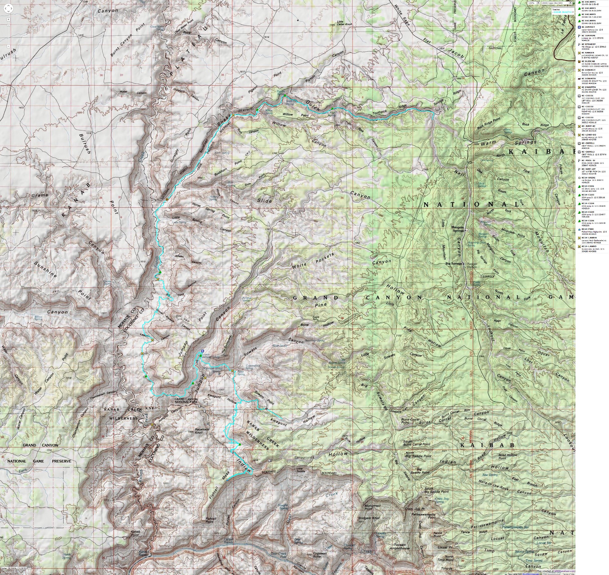
Maps:

| ||||
for a full-resolution map, click here. Caution - do not use this map or gps track for navigating the route. It can be a tricky place
Summary: Five of us backpacked from Sowats Point to the Esplanade
level above Kanab Creek. We ventured to Indian Hollow Spring to basecamp for two nights, climbing Fishtail Mesa
from this camp. Then, we continued along the Esplanade on the Ranger 41 Trail to Kanab Creek, and from there
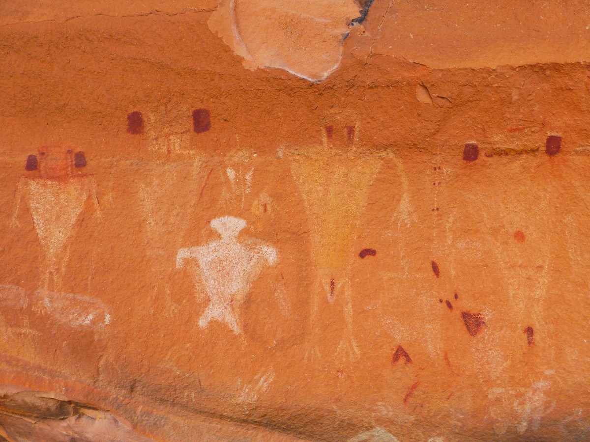
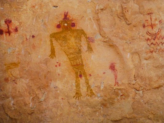
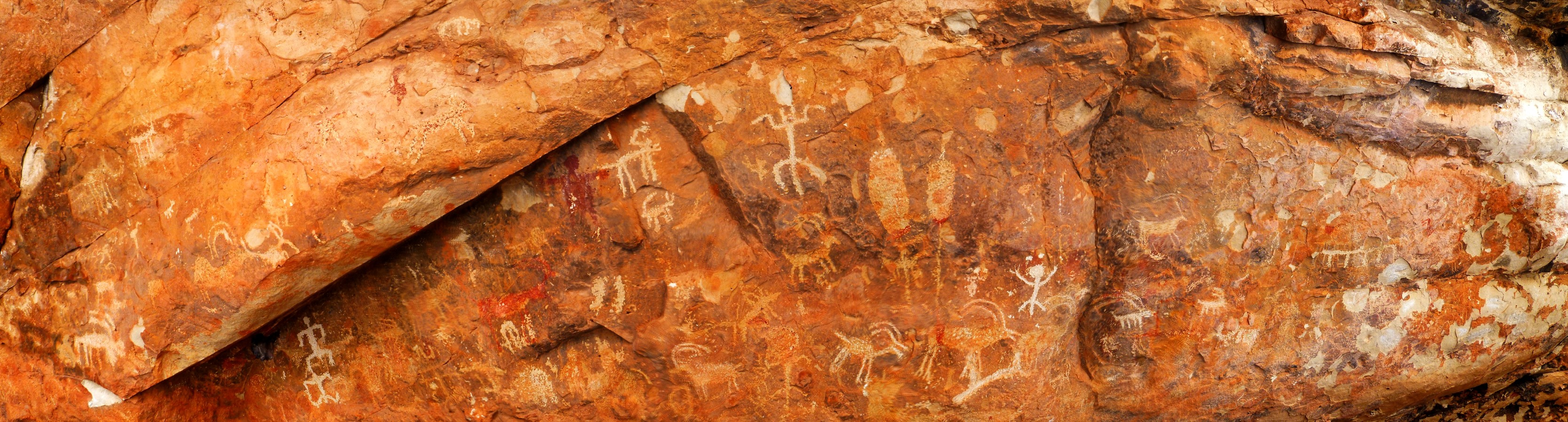
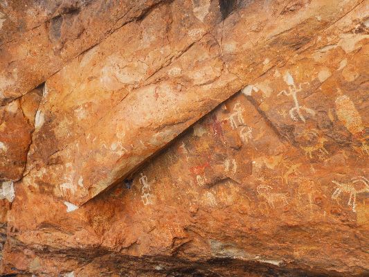
to Snake Gulch. Enveloped in a heavy snow storm, we exited Snake Gulch, missing most of the fabulous pictos hidden
there. Bob and I slithered the shuttle to retrieve Bob's vehicle from Sowats Point. The cache buckets are still
out there. Here's my report about Snowmageddon in Snake Gulch and Fishtail Frolic in Kanab Creek Wilderness,
a wonderfully deluxe adventure.
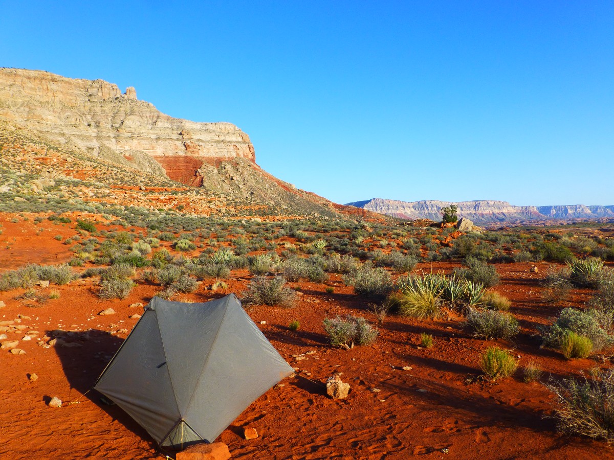
Prelim: To Sowats Point: Camp @ 6200'
Contents: 115 photos, 10 videos, 3 panoramas, and one dynamic map. Enjoy
It's splattering rain when I see the gray 4-runner at Jacob Lake.
Bob Bordasch? Yes, it is. Onto forest roads we venture, meeting Ben, Decker, and Bert at FR 423,
then continue with all three vehicles to the Snake Gulch TH, leaving two and sardining into Bob's
vehicle for the jaunt to Sowats Point and the start of the Jump-up - Nail Trail. About a mile back
from the TH, we find a good camp and set up table, chairs, food and get acquainted. The sun is out
and times are good on the Kaibab Plateau. Thanks to Bob for organizing this junket.
| ||||
 wKanab-Snake2014-banner-day1-1 Ben, Bob, Bert at Sowats Pt.jpg |
 |
 |
 |
 |
 |
 |
 |
 |
 |
 |
 |
 |
 |
 |
 |
 |
 |
 |
 |
 |
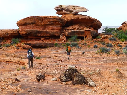
Day 1: Picto Deluxe, to Indian Hollow Spring:
6.9 miles; ERM = 13; camp @ 4500'.
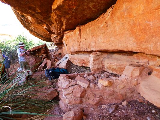
A mystical force, akin to animal magnetism, draws us into the shade of
a brush-shrouded overhang. Gloriosa! The Ancients also stopped here - to build a granary and draw some
rock art. Deluxe.
We've hiked off-route since dropping off two 5-gallon buckets as cache at
the top of the Esplanade. Blackbrush. Following segments of what is probably an old horse track, we venture
toward Indian Hollow Spring (not in Indian Hollow).
Back at the artwork, we stroll up canyon in hot sun, seeing another panel,
replete with figures sporting ear bobs. We camp about a half a mile from the spring and I walk back to a
nose of rock that looks suspicious - a cowboy camp with an old pack stove, a trove of horseshoes, some old
bulging unopened cans with labels rusted off, and a better place to camp. After an enjoyable rinse, dinner
follows with a three-course meal of soup, appetizer of olives and feta cheese, and polenta and chili. Yum.
Ben and Bert set the expectation bar high with this meal. Sunset approaches with the chortle of a distant
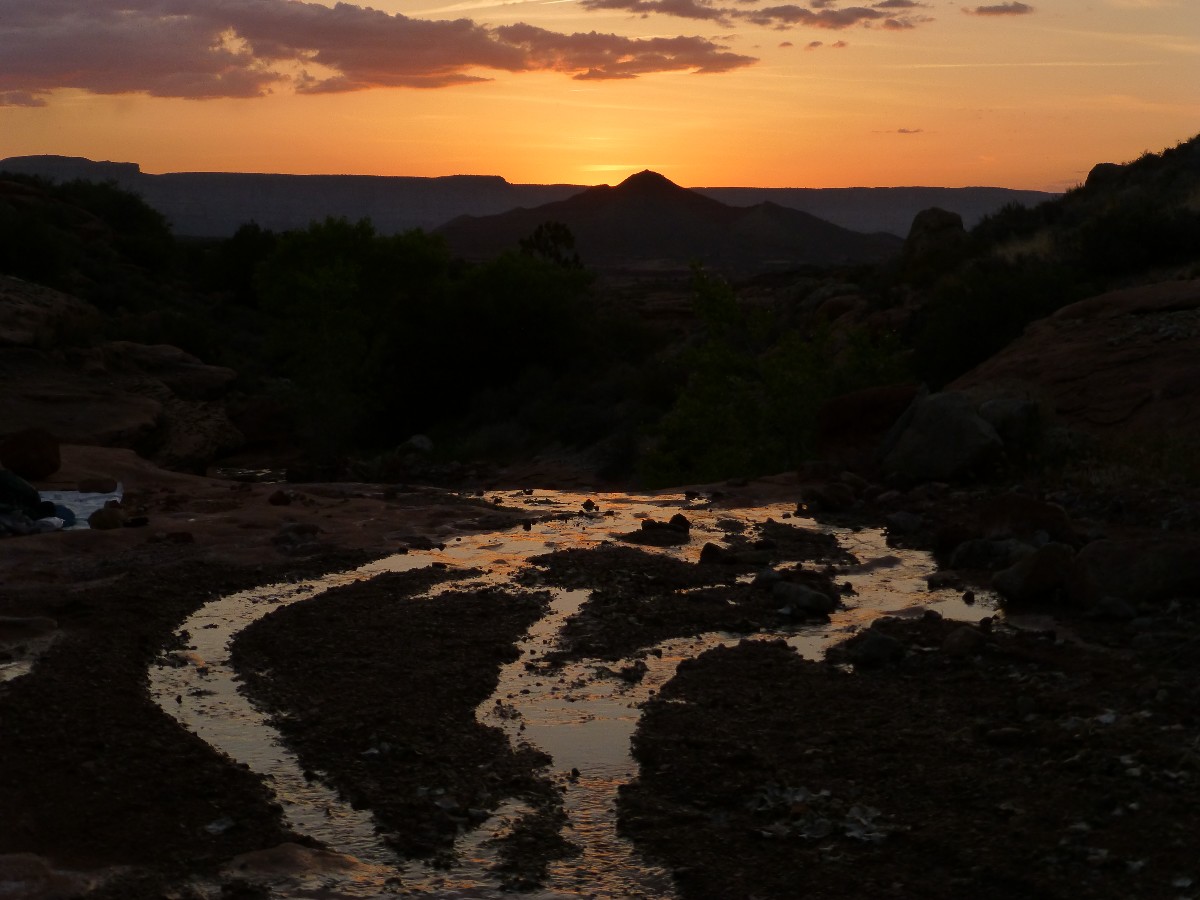
froggie. The sun sets behind Racetrack Knoll and midges chew on my ears.
| ||||
 |
 |
 |
 |
 |
 |
 |
 |
 |
 |
 |
 |
 |
 |
 |
 |
 |
 |
| ||||
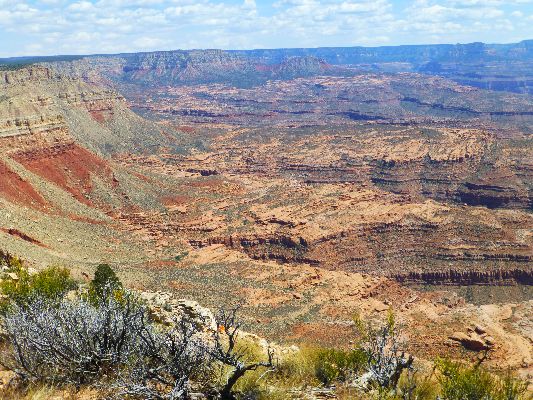
Day 2: Fishtail Frolic? To top of Fishtail Mesa (day trip):
8.7 miles; ERM = 18.
The rocks skitter, leaping from the angle of repose. The whole incline
feels like it's in motion. Steep. Seemingly endless. Precarious at times. We're sliding down the scree
below the flattish summit of Fishtail Mesa. It's a bit like this country's slide into oligarchy, to the
casual eye it looks stable, yet it could all rumble downhill in an instant.
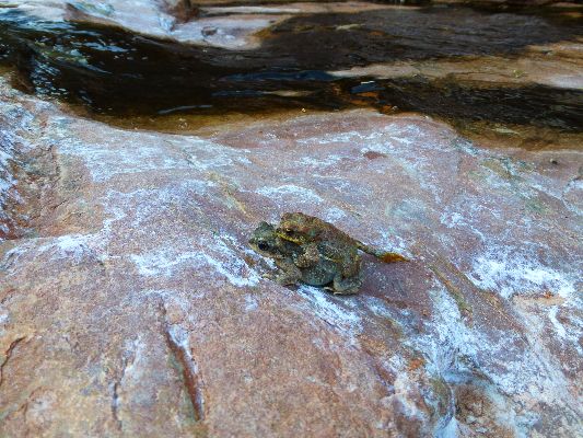
We start the day walking over and into Indian Hollow Canyon, reaching the
canyon floor at a froggie pond. Then, upstream to below the saddle of Fishtail Mesa and up to the saddle
- steep, yet not as bad as where today's tale started. Climbing. Ben and Bob continue up the nose from
the saddle, while Bert, Decker, and I contour around and up the steep slope to almost the top. After
rendezvousing with Bob and Ben, who have come rolling along from the nose, we climb up a chute and wander
across the mesa to the high point. Then, we return to the chute and then the angle of repose slope and
finally back to Indian Hollow. Tired. Beginning to bake.
Back at camp, it's time for a bucket bath and then it's my turn to cook
(orzo with dried meat and peas, egg flower soup, humus and pita bread). It's growing dark and the froggies
are hopping over the slickrock near the water. Step carefully. Time to study the inside of my eyelids.
It's a frolic (not) of Fishtail I won't want to repeat. The others echo this opinion, noting that it's
good to have scrambled Fishtail, yet it's probably not an adventure they want to repeat.
 |
 |
 |
 |
 |
 |
 |
 |
 |
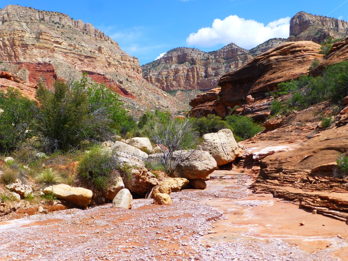
Day 3: Jumping down into Jump-up, to near Jump-up Spring:
10.7miles; ERM = 20; camp @ 4080'.
The wind buffets the Jump-up Canyon Cottonwoods, sounding like a distant
train at times. Many of the former Cottonwoods have been ripped out by a last-season flood and the base of
the canyon is now a gravel swirl. It's been a day of dull and cloudy sky, with poor photography conditions.
We're above drainage level in a cul-de-sac of Esplanade, hiding from wind and potential rains. Mostly protected.
The day starts with the roar of stove and calls of "Hot water!" at 5 a.m.
Groan. The various assorted body parts whine like sarah palin, the part-time governor and full-time quitter.
Some movement helps. We mostly retrace our route to the cache and reload, with lots of "extra" weight.
Rather than cut-up the buckets and carry them with us, we put our trash and Bob's webbing (brought for use
on Fishtail) into the buckets and re-cache them. The plan is for me to hike in at the end of the trip and
retrieve the buckets. (Editor's note - the buckets await retrieval - see the last day notes.)
Then, on to Sowats Canyon for lunch, before climbing out and winding our
way here, to Lower Jump-up Spring. We see the first people of the trip, and also the last. Ahh, wilderness.
 |
 |
 |
 |
 |
 |
 |
 |
 |
 |
 |
 |
 |
 |
 |
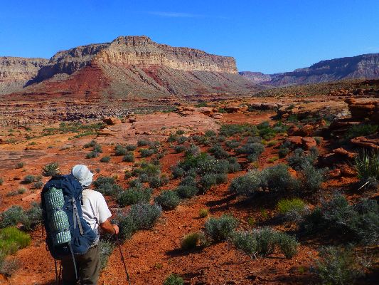
Day 4: Esplanade Ranger:
7.1 miles; ERM = 11; camp @ 4200'.
Strolling the Esplanade Garden on the Ranger 41, cactus, four o'clock,
paintbrush, paper flower, phlox, banana yucca, indigo bush are all in fine form. A garden. Great walking,
tremendous long-Ranger views, lilting the Ranger 41 Trail. There is a good measure of wind and some clouds
however. We search for potholes to which the hikers we met at Jump-up alluded, and also find some secret
pictos under an arching dome of sandstone. Lovely.
Contouring on, we dump packs at a camp spot two miles distant. Bob, Ben,
Decker, and Bert explore for water off the steps toward Kanab Creek while I return with an empty pack to the
first found potholes. Meager. Straining the water through a handkerchief helps remove the mosquito larva,
other debris. 28-pounds of water in the pack, argh. Yet, prior to returning to camp, I enjoy a bucket bath on
the slickrock.
Returning to camp, Decker waves and calls "We found good water and have enough
for camp and personal use!" It is better quality than the water I retrieved. So, I keep the water I already
treated and donate the rest to my bucket. Ben and Bob use it and enjoy a partial slickrock bath on the gorgeous
sun-warmed Esplanade.
The breeze is still with us as Decker cuts salami and cheese and plops them on
crackers for an appetizer, while Ben cooks leek soup. Fine. Then, mushroom curry over couscous as we don shirts,
then jackets and wool hats. It's good to be sitting on this insulated pad. Chilly. Leaning back against our
slickrock of Esplanade, we peer at the Kaibab, Coconino, Hermit layers as they glow in the low-angle light. Good
night Coconino, good night Hermit Shale....
| ||||
 |
 |
 |
 |
 |
 |
 |
 |
 |
 |
 |
 |
 |
 |
 |
 |
 |
 |
| ||||
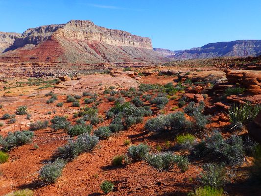
Day 5: Ranger Redux, to Kanab Creek:
10.7 miles; ERM = 18; Camp @3650'.
The sweep of rock escarpment is as vast as an oligarch's portfolio,
and this morning, it's as cold as the heart of a banker, which has been replaced by a calculator.
Think of the heartless cheney and other selfish repulsicans, now that's cold.
It's glorious yet frigid. Nearly as frigid as Ann Coulter's compassion.
After a cool and windy night, we start on the Ranger wearing several
layers of clothing. As the sun arrives, so do the shorts. Later, Bob remarks on the heat. We enjoy it
all on this Esplanade terrain. Ahh, weather diversity.
Esplanade, keep on rolling, to a tune we are strolling. There's a
surprising amount of elevation change today. We pause at Dinner Pocket and explore down to Kanab. One
dark coffee pothole along the way, nothing but rocks in Kanab. Will we find water in Kanab upstream?
Humm. Continuing on, I find a natural arch (natural bridge?) and we get off route due to storms last
monsoon that swept away cairns and the trail. The day drags on. When we reach Kanab Creek, there is no
creek and we don't find water for some distance.
Eventually, there is water. Frogs serenade as we throw camp into place
and enjoy the last bits of sun on the cliffs. I'm sleeping near what others termed the "bridal nook" on
a previous trip. Of course, I was hiking with Kathleen, so "bridal" has some relevance. A topic for
excellent dreams? Why not.
| ||||
| ||||
 |
 |
 |
 |
 |
 |
 |
 |
 |
 |
 |
 |
 |
 |
 |
 |
 |
 |
Day 6: Desiccated Snake Slog, to above Wildband Spring (near Pigeon Spring):
15.2 miles; ERM = 23; camp @ 4950'.
The desert columbine shudders in the blasting wind, perched on a travertine
shelf at (thank Darwin!) wet Willow Spring. Wondrous. Sure, there was plenty of water in Kanab above our Day
5 camp - yet we hiked this stretch mostly before the sun arrived. Disappointment - no water at the Ed Hatch Cabin,
although the cabin appears to be holding up OK. This Zane Grey panorama has a tattered look, cowburnt and
desiccated. We did find water at Rock Spring. The Willow water makes us dream of a nearby camp, yet Ben,
Decker, and Bert must catch flights from one of those waterless cities that should not exist, Las Vegas,
tomorrow - and we're substantially behind schedule to help this happen. Otherwise, we're right on schedule,
strolling (now officially a slog) Snake Gulch.
On to Wildband Spring we plod, on and off the disappearing trail/horse track,
scraping and thrashing through blackbrush/sage created by years of cowburning (overgrazing), welfare ranching
on our public range. Soon we abandon all hopes of a trail and hike in the drainage. Certainly, the Grand Canyon
Trust is doing a better job, after drastically reducing the stocking on the allotments it now holds (see links
section). It's another of the many myths of the West. Rarely did anyone take good care of public grazing lands,
or pay a fair AUM (Animal Unit Month) grazing fee. Can you say "welfare ranching!"? How many (any?) repulsicans
do you hear whining about these welfare artists and loafers at the public's expense? Sadly, in addition to
supporting these welfare workers, the land suffers greatly, as evidenced by the lack of grass and the monoculture
of blackbrush or, in some areas, sagebrush. Sad. Admittedly, this welfare operation is nothing like the
horrid coddling and preferential treatment of bankers, wall-streeters, and corporations, where the game is
rigged to enhance the rich at the expense of those in the middle and lower classes. How many bankers have
gone to jail over the destruction of the economy? Zero. Oligarchy. Oh, they're just following the golden
rule, those with the gold rule. Kind of like repulsican jesus: support the money changers, throw out and
refuse to feed the poor (e.g., cuts to food stamps, etc.), pro-life by voting for guns rather than life, condone
torture, refuse healthcare to all but the rich, etc. and etc.
At Wildband, Ben has climbed up and over a dividing ridge and is toting back
25 liters (50 pounds!) of heavy water. Reorganized, we continue to a cowboy alcove that Bert has located near
Pigeon Spring (mudhole). A good area to camp because the horribly vigorous wind seems to be bringing in a
storm front and we may need the shelter (how prophetic). Argh, 15-miles plus today. I'm too tired and it's
too late to continue writing.
| ||||
 |
 |
 |
 |
 |
 |
 |
 |
 |
 |
 |
 |
| ||||
| ||||
| ||||
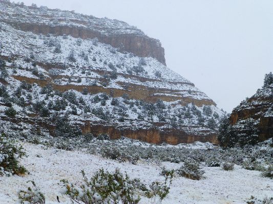
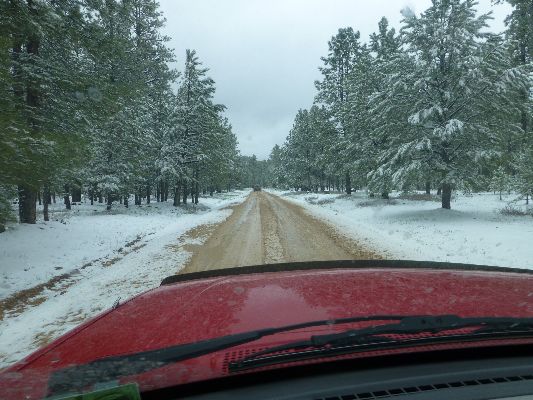
Day 7: Snowmageddon in Snake Gulch, to TH and run the soggy shuttle:
9.7 miles; ERM = 13. Total GPS miles = 69.0. Total ERM = 116.
My cold toes are swishing in sodden boots as hail twangs off my hat,
frosted nose, and anorak. Burr. Welcome to snowmageddon in Snake Gulch. Argh.
Bob and I pause in an alcove near Table Rock as the hail changes into
heavy snow. We see only the ghostly shapes, not the vibrant pictos. Huge Basketmaker anthropomorphic
figures in red, yellow, accented with a green slash here and there. Somewhere. Out there on the canvas
of Coconino, through a veil of snow. Plodding and sloshing on, we're glad the trail has improved, yet
now it's partially obscured by the snow. On and on, in the silence.
Reaching the TH, we note that Ben, Bert, and Decker were not far ahead
of us - because the snow outline where their car was parked can be distinctly seen. Here's hoping they
made it out to paved roads without incident.
Now it's time for the return shuttle. Yikes. Slow and gumbo. It takes
nearly three hours to run the 60-mile (round trip) shuttle - with the 9 miles of Sowats Road by far the
worst. (The video shows the "good road," FR 22 - no hands were free to video the Sowats Rd.) Deep ruts,
mud, slippery at times. And, Bob and I did not see anyone, even on the road, until we were nearly to Sowats.
Yet, we're warm and moving forward. Arriving at Sowats Point, we get a glimpse of The Country through the
snow veil, when it's not popping into our eyes, that is. The cache will have to wait for another trip - it's
time to get off these roads and muse about the Fishtail Frolic and Snowmageddon in Snake Gulch.
| ||||
*ERM: Energy Required Miles, are there data to support this
mileage adjustment?
Journal of Outdoor Recreation, Education and Leadership
Petzoldt first proposed his theory in his 1976 book “Teton Trails” to
help backpackers plan trips and calculate their energy needs on mountain trails. “Petzoldt defined one
energy mile as the energy required to walk one mile on the flat. He recommended adding two energy miles
for every 1,000 feet of elevation gain, so a person hiking one mile and 1,000 feet upward would use the
equivalent of three energy miles,” Phipps said.
Petzoldt’s energy mile theory was just a reflection of the mountaineer’s
“gut feeling,” Phipps said. The theory had never been tested in a laboratory before the study began in WCU’s
Exercise Physiology Laboratory in the spring of 2010, Phipps said.
To determine the validity of the theory, the study measured the energy cost
and perceived exertion for walking on flat ground, with and without a 44.5-pound backpack, and up an elevation
gain of 1,000 feet, with and without the backpack, through the collection of metabolic data, Phipps said.
Twenty-four student, faculty and staff volunteers, including 12 males and 12
females, went through four testing sessions as the research continued into fall semester of 2010. The study
results showed that the additional energy cost for ascending 1,000 feet ranged from 1.34 to 2.02 energy mile
equivalents, for an average of about 1.6 miles, compared to Petzoldt’s use of two energy miles for each 1,000
feet. The range revealed by the study was due to the “hikers” personal weight differences, Phipps said.
“It is remarkable that Petzoldt’s energy mile theory is so close to the actual energy cost measured during our
study,” Phipps said. “In the field of outdoor education, it’s important for leaders to include an estimation
of energy requirements during the planning of hiking trips.”
Phipps said the energy required for hiking up steep mountain trails would vary
for individuals and groups, and the variables of the trail would also factor in, but he recommends that
backpackers stick with Petzoldt’s idea of adding two energy miles for every 1,000 feet of elevation gain when
planning trips.
The Validity of Petzoldt's Energy Mile Theory, 2010
Authors: Maridy McNeff Troy, Maurice L. Phipps
Publication: Journal of Outdoor Recreation, Education, and Leadership
| ||||
for a full-resolution map, click here. Caution - do not use this map or gps track for navigating the route. It can be a tricky place
Books:
Eaarth : making a life on a tough new planet, McKibben, Bill,
Time Books, 2010.
Maybe one : an environmental and personal argument for single-child families, McKibben, Bill, Simon & Schuster,
1998.
The end of nature, McKibben, Bill, Random House, 1989.
A River Runner's Guide to the History of the GRAND CANYON,
Crumbo, Kim, JOHNSON BOOKS 1880 South 57th Court, Boulder, Colorado, 80301
1994.
WV reports about the Kanab Cr. - Deer Cr. Area:
Kanab Kaleidoscope Cruise: Sowats - Kanab Creek - Deer Creek - Monument Point (2013)
Torrid Tapeats - Fishtail Frolic: Thunder River-Colorado-Deer Cr. - North Rim (2009)
Long Ranger: Kanab Creek Wilderness: Snake Gulch to Sowats Point (2006)
Jumping Up into Thundering River (2005)
Jumping Up Into Kanab Creek Wilderness (2004)
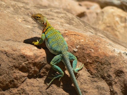
Click here or on the Looking Lizard to go to all WV reports about The Grand Canyon
| ||||
Hands on the ground conservation at Kane Ranch (Grand Canyon Trust), pdf file, 2.3 mb.
the geology of the Grand Canyon by the NPS
| |||||
| |||||
| |||||
| |||||
| |||||
| |||||
| |||||
 |
 |
 |
|
Wild Vagabond Main |
Trip Report Index  |
Caveat  |
|---|


