Backpacking Kanab Creek to Deer Creek: Sowats Point / Jumpup Canyon / Kanab Creek / Colorado River / Deer Creek / Monument Point
October 2 - 8, 2013
Text © copyright by Rob Jones and Photos © copyright by Rob

|
Kanab Kaleidoscope Cruise:
Backpacking Kanab Creek to Deer Creek: Sowats Point / Jumpup Canyon / Kanab Creek / Colorado River / Deer Creek / Monument Point October 2 - 8, 2013 Text © copyright by Rob Jones and Photos © copyright by Rob |
 |
|
| |||||
|
| |||||
| ||||
Co-Adventurers: Dave Cash, Joe Ryan, Earle Hayden, and Darrell Ashcraft
Kaleidoscope: a variegated changing pattern or scene, as in a kaleidoscope of colors.
ERM - Energy Required Miles. A mile is added for every 500' elevation gain or loss.
It's a very serviceable method of estimating energy required miles.
Yet, ERMs do not account for the texture of the topography. This route is tough going,
at times because there is no trail in Kanab, and the section from Kanab to Fishtail Canyon is truly a cheesegrater
experience.
Total trip - (per my GPS) of 44.8 miles and total ERM = 75, yet, because of poor signal for the GPS, some mileages and ERMs are estimated.
25 videos; 139 photos -- I suggest you start downloading the videos while you read the narrative and view the photos. Enjoy!

| ||||
for a full-resolution map, click here. Caution - do not use this map or gps track for navigating the route.
“The good thing about science is that it's true whether or not you believe in it.” - Neil deGrasse Tyson
Summary: Five of us backpacked from Sowats Point, through Jumpup Canyon
(with its Redwall narrows), to Kanab Creek and down Kanab Creek to The River. We thrashed along The River to Deer Cr.
Climbing out of Deer Creek, we entered Surprise Valley and took the Thunder River Trail to the Esplanade level.
We exited the canyon country via the Bill Hall Trail to Monument Point.
| ||||
 |
 |
 |
 |
 |
 |
 |
 |
 |
 |
 |
 |
 |
 |
 |
Prelim:
Dave has the permit and he invites the rest of us usual suspects to join in
on a Kanab Creek adventure. Today, October 1st, we gather at Indian Hollow CG and celebrate the start of
this long-awaited Canyon cruise. Italian sausage spaghetti, warm garlic bread, wine, beer, cookies,
oatmeal bars, yum. Delectable. A brief sorting of equipment and shuttle plans for the morning and night
has deeply set in.
| ||||
Day 1: Sowat?! Jumpup-Nail to Mountain Sheep Spring :
5.6 miles; ERM = 10.6; camp @ 3600'.
"Shade!" Darrell cries as we lilt along the Esplanade. It's time for lunch
in the cool below this hamburger rock.
We 5 start down the Jumpup-Nail Trail after a calm night at Indian Hollow
CG. The top portion of the trail drops elevation steeply and over rolley rocks. Joe heads for the
Cottonwoods near the meeting of the Esplanade level for our first break of the day.
Now, post sunny rock bath, we're clustered around the kitchen at
Mountain Sheep Spring. A small group of pictos grace the SS (sandstone) near where the spring pops up
from the gravel forming the stream bed.. Glorious. A portion of the spring spurts from a small overhang,
fringed with maidenhair fern. It's music water for sleeping.
| ||||
| ||||
 |
 |
 |
 |
 |
 |
 |
 |
 |
 |
 |
 |
Day 2: Elephant Hide Kanab Clatter. To near Showerbath Spring:
8 miles?; ERM = 10.
There's a golden hue on the polished elephant hide of the Jumpup Redwall
narrows. Redwall limestone. Polished to a glisten and with its native color or steely gray.
Deep and narrow enough to preclude GPS reception. Weak signal, no signal,
the mileage is just a guess. Winding. Rock walking. Glorious. After a few miles, we intersect Kanab Creek,
deeply entrenched into straight-walled Redwall Limestone. The rock-hopping fun continues amidst occasional slick
silt from a week-ago flash flood and in intermittently baking full sun when the canyon has a N-S orientation.
Switchback and again, for miles. Then water, yet with a hint of sulfur at Pencil
Spring. Now, we're in or along water to The River, two days away. Today, it's a day for boots, although I step
into a quicksand-like ick that coats the boots with slippery red silt.
Now, I'm scrawling notes by headlamp, from our camp on a bench just upstream of
Showerbath Spring (named by John W. Powell) - amidst green grass and low Mesquite trees. A narrow strip of stars
wink at us from the notch formed by 1000' high Redwall cliffs. It feels late and my old bones scream for bed.
| ||||
 |
 |
 |
 |
 |
 |
 |
 |
 |
 |
 |
 |
 |
 |
 |
 |
 |
 |
 |
 |
 |
 |
 |
 |
| ||||
| ||||
Day 3: Rumble in the Jumble. To Slide of Susurrus/Whispering Falls junction:
6 miles?; ERM = 8; interminable boulder texture to the topography.
The house size boulders of Redwall choke the channel to where it's
either climb or swim. We chose the Redwall scramble. Then the slide across the silt-coated rocks
and sand, arms windmilling at times for balance, courtesy of the recent flood. Yikes. It's a tedious
trip to the mouth of the canyon cradling Susurrus. The Slide. AKA Whispering Falls. Along the way,
we pause at Scotty's Hollow and walk the short distance to the spiraling falls. Cascading clear water
sings like a nymph in a glen.
Each side canyon and sharp turn in the canyon is graced with a huge pile
of boulders perched over deep pools. Eventually, we reach some glorious Muave Limestone walkways - in
sight of the depression that holds the mystic Slide.
The once good camp across from the canyon of Susurrus is gone, whisked
away by a flood, so we make do with a camp in the mouth of the Susurrus Canyon. A cool, nearly cold,
breeze courses down this canyon, yet fails to diminish or cool our martini-fueled evening. Yes, Joe
has again produced the super-size Nalgene martini, replete with green olives. Powerful stuff. We chat
about other trips, the trip today, future trips. It's wonderful to have dry feet. Cool night.
| ||||
| ||||
 |
 |
 |
 |
 |
 |
 |
 |
 |
 |
 |
 |
 |
 |
 |
 |
 |
 |
| ||||
Day 4: Sliding from Susurrus. To Susurrus, to The Confluence with The River:
5.5 miles? ERM = 7.
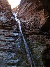
The glide of water whispers, swishes, and races down the slide, terminating
in a brief fall into a deep turquoise pool. Sparkles of water drip from the over-arching cavern into the pool,
appearing like champagne bubbles. Dave dives in, shattering the whisper and initiating the fun, followed by
Earle and Joe.
Getting to the Slide requires a minor scramble and a waist-deep wade. We
literally and metaphorically immerse ourselves in the aura of this arena.
Then, after finishing de-camping, we slide and glide down Kanab Canyon,
occasionally enjoying luscious Muav walkways and marveling as the canyon walls grow higher. By lunch, we're
shaded in a low nook of Muav or perhaps Bright Angel Shale near the confluence of Kanab and The River, from
which we are soon baked and we retreat up Kanab canyon to hide from the sun to while away the afternoon before
camping on the West side of Kanab Creek, enjoying a larger view of billions and billions of stars.
| ||||
| ||||
| ||||
| ||||
| ||||
| ||||
 |
 |
 |
 |
 |
 |
 |
 |
 |
 |
 |
 |
 |
 |
 |
 |
 |
 |
 |
 |
 |
Day 5: Jumble-ia. To Fishtail Canyon:
5.2 miles; ERM = 9.0. Topography cheese grater factor - 18 miles.
The cheese grater spiky limestone boulders eat boots and any body parts
that make contact with them. We're in the slow, tedious trudge from the mouth of Kanab Creek to Deer Creek.
The sun helpfully tracks behind the high South Canyon walls for a good deal of the day. Earle and Darrell
scout the "route" as we lumber along. Excruciatingly slow going, with little in the way of obvious route.
It's dramatically unlike the obvious route clothing worn by some delectable women. Yummy. We're not
having a yummy time today, as the rocks, infrequent sand, Mexican Locust, tamarisk, willows, mesquite,
and other grabby brush impede our paltry progress. The tamarisk reminds me of the tea-terrorists currently
causing a government lock-out, intrusive, antithetical to the purpose of a local plant, stealing water
from non-invasive species, a pox upon the Eaarth, disrupting what is good and natural about this ecosystem.
Joe rolls a rock and sprains some parts and we decide that this and our slow
pace form a good reason to camp at Fishtail. Finding clear water up canyon is a bonus. We locate a decent
camp just above The River, upstream of Fishtail, where last night's beavers patrolled for snacks, leaving
their tail-drag marks. Just prior to lights out, a kaleidoscope of warm colors reflect along The River.
A distant stratified striated double-breasted butte glows orange (buttes near Crazy Jug Point?). Darrell
quips about love "Put your wife and your dog in a car trunk and when you open it - see who's happy to see you."
Orion bursts out above the Southern wall, accompanied by billions and
billions of stars.
 |
 |
 |
 |
 |
 |
 |
 |
 |
 |
 |
 |
| ||||
| ||||
| ||||
Day 6: Oh Deery. To Deer Creek Camp:
4.6 miles; ERM = 9.5.
The horizontal evaporative cooler blasts from a free fall of Deer Creek Falls.
Refreshing. Joe nearly gets behind the falls. We've arrived at the falls after a journey starting at
Fishtail and progressing on slightly easier boulders and sand to the next canyon upriver, where a route
climbs to Cobblestone Natural Bridge, then continues through Siesta Spring (where we see a palm tree),
before dropping back down to River level. We climb around a Tapeats SS outcrop and back down and through
River-level springs and into the Deer Creek area. Surprisingly, despite the tea-terrorist lock-out,
non-motorized raft parties are still filtering through this area, and we enjoy a beer and some discussion
and some gazing at a sightly boatwoman. After a good amount of lounging, we hike up to and through the
Tapeats narrows, replete with ancient art work, mostly hand prints. The toilet is scenic and we have the
area to ourselves.
| ||||
| ||||
| ||||
 |
 |
 |
 |
 |
 |
 |
 |
 |
 |
 |
 |
 |
 |
 |
Day 7: Excellent Esplanade. To Monument Point (Bill Hall Trail):
9.9 miles; ERM = 21.
Puffing and grinding and gliding up from the spring of Deer Creek, the spring
that reminds me of an old girlfriend who enjoyed urinating in the outdoors, we enter Surprise Valley, slipped
and dipped out of sequence rocks - where we're walking around Redwall mounds far below the Redwall cliffs - and
into full penetrating sunlight. Over in the East cleft - can we hear or feel the resonating rumble of Thunder
River? Perhaps. I'd hoped to hike the loop from Deer Creek camp over to Thunder River and back along The River
- yet we used our day-off hiking from Fishtail to Deer Creek. Earle and Darrell are at the base of the
Redwall climb on the Thunder River Trail as Joe and I are taking photos of late season flowers surviving in the
shade, and Dave is admiring the sweep of rocks made by time, while contemplating another Canyon night or a return
to the beautiful blonde on the West coast. Maybe both.
Up the Redwall and onto the undulating joy of Esplanade SS walking. Strolling.
On the Esplanade, we are rolling. Under an arching bit of this sultry Supai level, we pause for a long lunch.
My lunch sack is nearly empty, a signal that out trip is closing. Along the Esplanade we lilt, pausing near
some pictos I found on an earlier trip - and one of the last good places for a (dry) camp. A quick visit to the
pictos and when I return - the others are gone, deciding to head for the rim.
Earle and I keep the throttle open and I chat a fond farewell as we pass Dave,
Joe, Darrell on our way to Monument Point and running of the return shuttle. Great hiking with you. Thanks for
making this a wondrous adventure. Dave, Joe, and Darrell slow some, apparently the pull of The Canyon area is
retarding their climb to the rim.
Driving after the shuttle, it's fully dark as I drift along FR22, glittering
eyes and glowing Aspen leaves are scattered along the side of the road. Road markers. Terrific country and
camaraderie, I muse, as I hurtle off the plateau, for home.
 |
 |
 |
 |
 |
 |
 |
 |
 |
 |
 |
 |
 |
 |
 |
"Capitalism: Nothing so mean could be right. Greed is the ugliest of the capital sins."
- Edward Abbey"Reality has a well-known liberal bias."
- Stephen Colbert.
| ||||
| ||||
 |
 |
 |
Maps:

| ||||
for a full-resolution map, click here. Caution - do not use this map or gps track for navigating the route.
Books:
Eaarth : making a life on a tough new planet, McKibben, Bill,
Time Books, 2010.
Maybe one : an environmental and personal argument for single-child families, McKibben, Bill, Simon & Schuster,
1998.
The end of nature, McKibben, Bill, Random House, 1989.
A River Runner's Guide to the History of the GRAND CANYON,
Crumbo, Kim, JOHNSON BOOKS 1880 South 57th Court, Boulder, Colorado, 80301
1994.
WV reports about the Kanab Cr. - Deer Cr. Area:
Torrid Tapeats - Fishtail Frolic: Thunder River-Colorado-Deer Cr. - North Rim (2009)
Long Ranger: Kanab Creek Wilderness: Snake Gulch to Sowats Point (2006)
Jumping Up into Thundering River (2005)
Other WV reports about the Grand Canyon:
Click here or on the Looking Lizard to go to all WV reports about The Grand Canyon
| ||||
Related Links:
the geology of the Grand Canyon by the NPS
the geology of the Grand Canyon by Bob Ribokas
More Truth Than Joke:
| ||||
| ||||
| ||||
| ||||
| ||||
| ||||
| ||||
| ||||
| ||||
| ||||
“The good thing about science is that it's true whether or not you believe in it.” - Neil deGrasse Tyson
"Capitalism: Nothing so mean could be right. Greed is the ugliest of the capital sins." "Reality has a well-known liberal bias."
|
Wild Vagabond Main |
Trip Report Index  |
Caveat  |
|---|