Text and photos © copyright by Rob Jones

Co-participants: Solo hike by Rob (Wild Vagabond)
camera: Panasonic DMC-ZS60
|
| |||||


| ||||

|
| |||||


|
| |||||


Las Colinas to the Canelo Hills (March 16 - 20, 2019; Part 1)
Completio±: Mexico Border to the Canelo Hills (April 14 - 16, 2019; Part 2)
Total Miles = 88.5; ERM = 154
Miller Peak Wilderness, Huachuca Mtns., Mt. Wrightson Wilderness, Canelo Hills, and so much more.
|
| |||||
| ||||
|
| |||||
|
| |||||
Overview: This report contains Parts 1 & 2, 2019 of the Completio± of The Quest to Hike the AZT, Arizona Trail. I envisioned this as one hike and indeed planned it this way. Yet, I got sick and had to quit at the Canelo Hills, later returning to complete the Quest. So, my apologies, this report is a bit disjointed, opening with the sole North to South hike of the Quest, followed in Part 2 with the Completio± of The Quest. Now, on to the Quest.
See all the sections I have hiked on the way to Completio±! of the Quest to hike the AZT by clicking on this link to all WV trip reports about hiking the Arizona Trail.
Preliminary Panoply: When I start planning for what I envision is the final AZT (Arizona Trail) section, conditions are looking good. Now, on the eve of departure I'm considering a flip flop, starting at the North end and hiking South to the border. How come? Snow and more snow in the Huachuca Mountains, specifically the Miller Peak Wilderness, which takes the AZT up to around 9500 feet. Reports are in the feet of snow, with wind, for the Miller Peak Wilderness. Yowza.
| ||||
Day 1: Kentucky Kamp Kruise:
10.9 miles - 10.1 AZT miles + 0.8 access walk. AZT mile 86.8 to 76.7.
*ERM estimated at 16. (*See a complete discussion of ERMs at the end of this report.)
So, to take the microspikes? The snow shoes? A panoply of equipment will
be required, argh. And, then one has the pleasure of carrying this Winter gear the rest of the section. Argh.
Yikes. Sure, the forecast is for clearing and rising temperatures, yet will
this be sufficient for general clearing of the North-facing high points, and within my time frame? I can't move
the trip because of a following Grand Canyon VIP (Volunteer In Park) excursion.
Reconsidering, I contact AZT Trail Angels Steve C. and Joe D. and work out a
flip flop of my AZT plans.
Therefore, March 15th finds me swapping food bags and checking equipment a
final time before the dreary drive through and around the overpopulation sprawl of Phoenix and then Tucson
before the relative calm of highways 83 and 82 and Patagonia, Arizona. Along the way I stop where the AZT,
Arizona Trail, crosses Sahuarita Road, a spot where last year I rigged the portable shade of the umbrella to
escape the roasting sun. Good times. Here, I place jugs of water for current AZT hikers in the storage box
near the road crossing.
The town of Sonoita is vaguely familiar because I recall Marv and I stopped
here and stayed in the fairgrounds, where we were haunted by a phantom flag wind on Day 2 of the glorious
38-day Border Bop bicycle tour from Mexico to Canada. Most excellent times - link.
Finally to Patagonia, where the caffeine jitters gradually wear off as I
fiddle with equipment. It's good to be stationary, although my body is still yo-yoing like a treadle sewing machine.
The flagging flies in the brisk breeze along a ridge
overlooking distant snow capped Mount Wrightson. Riders of an equestrian endurance ride
canter past, mule-faces snorting on the uphill. Vee the horsey flies past and I snap a
photo where all his hoofies are off the ground.
Earlier, after good conversation with Steve Chaffee
during breakfast in Patagonia, Steve shuttles me to an access to the North end of Passage 5.
This is the same entrance Steve and I used last year when I hiked the
Saguaro Sortie: Hyponatremia to Hypothermia on the AZT- link.
I enjoy my time with Steve, and we jabber away while
hiking the access route to the AZT. Steve and I part company exactly where we did last
Spring, although this time I am hiking South, toward completion of the quest to hike the AZT.
Link to Steve's book,
The Arizona Trail: Passages in Poetry, Stephen N. Chaffee, 2018, Wheatmark Publishing.
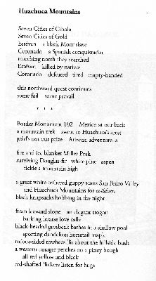
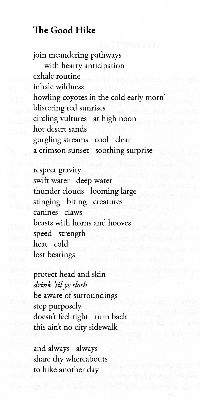
You will see two of Steve's poems in this report, "Huachuca Mountains" and "The Good Hike,"
(reproduced by permission of Stephen N. Chaffee).
Steve points out that this is where a yuge chunk of
the AZT will be rerouted if/when
the unworthy Rosemont copper mine will foul groundwater, eject and destroy migration
corridors for jaguars and everything down-food chain. Development will be outsourced
to a Canadian corporation (more corporate socialism on the way - you will be paying for
loss of lands, loss of water, and then the eventual clean-up after the miners go bust).
This misguided, selfish raping of public lands haunts my thoughts as I start up the
low rise on the AZT. Let them mine mar-a-largo, I suggest.
I meet Blazing Turtle and Justin, from San Francisco,
at Enzenberg Canyon and stop
for lunch #1, cool water, conversation, and respite. Glorious.
Along the open ridge, I'm now on a forest road, and accompanied
(or sensory assaulted) by stinky 100 decibel ORVs. And the wind, it's nearly cold at times.
The ORV drone fades, the wind continues, natural quiet returns.
Finally to Kentucky Kamp, replete with adobe wall structures,
an AC outlet, an outhouse, picnic tables, and water. Lovely. Deluxe even. Matt and Greg,
bike packers, are enjoying an overnight from Gabe Zimmerman TH and are at the Kamp, and we
enjoy a wide-ranging discussion into dark and the beginning of tonight's song dog serenade.
A phantom rain appears as I am almost asleep. What?
Day 1 photos - Completio±, AZT


Day 2: Pipelining it to Anaconda. To AZT 60.1:
16.6 AZT miles. ERM = 25.
Frost coats the weathered wood on the picnic tables.
Setting out, I'm soon following the pipeline that long ago delivered water to the hydraulic
miners of Kentucky Kamp. Dropping into the Apache Spring area, I encounter gorgeous Jane
from Utah. A piped siphon system brings the mining water through this dip. Rivets hold
the plates of the pipeline, apparently individually riveted by hand.
Careening through the Alligator Junipers, along the route of
the Santa Rita Pipeline (from Bear Springs to Kentucky Kamp) and beneath the snowy brow of
Mt. Wrightson, the day is progressing nicely.
It's a bit of a drag as the mileage along the ditch mounts.
However, the contour of the pipeline and later the ditch makes for reasonable walking. I
stop at Big Casa Blanca to again rest the feet, eating a late lunch while drying the tent.
The clear water oak tub of Bear Spring is delightfully enjoyed, then it's up, up over a high
saddle where I see remnants of snow, popping again in and out of the Mt. Wrightson Wilderness.
Then, a dramatic long downhill on a road occasionally coated with rolly rocks.
Cold wind, gathering clouds, and just enough rain spatters
prompt me to cover the pack and unleash the umbrella. Wind whips as I repeatedly ford Temporal
Gulch Creek on the way to Anaconda Spring. I'm guessing there are 12 creek crossings, where
rocks are needed to keep the boots dry. Dragging.
I find a camp and thankfully the wind drops. Dark collapses
as I filter water, finding the filter clogging and switching to AquaMira. It's not as fun
working into the dark thirty hour.
Dinner, exhaustion, collapse, oh my.
 |
 |
 |
 |
 |
 |
 |
 |
 |
 |
 |
 |
 |
 |
 |
Day 3: Corporate Socialism Bypass. To Harshaw TH, AZT 48.3:
14.8 miles - 11.8 AZT miles + 3 miles reroute. ERM = 18.
The external heat from the cook stove is welcome this chilly morning.
Later, I'm cradling the tube of well-sweetened coffee to continue the warming, alternating between frigid
hands and clasping the coffee cylinder between the legs, where those big arteries are pumping. Ahh.
Dew coats everything and cold air slumps down the canyon. I get on the
AZT to finish warming up. I soon meet Happy Joe and Tyson on the bypass.
The bypass. The bypass temporarily takes hikers far off the AZT, up
through clogged drainages and around ridges to avoid clean-up activities at an old mine site, per usual.
The bypass detours hikers through the klingon bushes (cat claw, mesquite, locust, other grabby plants)
and way up on a ridge and another higher ridge before returning to the AZT after several miles of wandering
excursion. Screaming yellow lichen decorate some of the erratic boulders in the high valley. Photogenic.
The klingon bushes cling on with tremendous gription, unzipping clothes and flesh if not delicately removed.
Keep pulling against the klingon and one is shredded. Because of corporate socialism, where miners
receive all manner of graft and gift from the public, then, following the miner business model, go bankrupt,
leaving the public to clean up and generations of grandchildren to deal with toxic water and landscape. Horrid.
This is yet another aspect of the republican way, give all to amoral immoral corporations and cut social
programs to pay for unearned corporate greed. Supporters of repulsican policy vote against using their
tax dollars for public service, instead providing corporate welfare without benefits except to the very
very rich. This bypass avoids mine toxin cleanup efforts, of course funded by you. The mine corporation
cashed the checks, then left toxic brew for you. Corporate socialism.
| ||||
 |
 |
 |
 |
 |
 |
 |
 |
 |
 |
 |
 |
Day 4: Canelo Concourse. Border Patrol Chauffeur and Concierge Service.
To Canelo TH area, AZT 35.0:
13.3 miles. ERM = 18.
Looping through the sparse oak woodlands, the morning air is cool and fragrant.
AZT aroma. Along rides Liz, a bike packer; and walks Junko, Kevin from Flagstaff.
The trail rolls, weaving around (mostly) rounded hills.
I pause near well-named Red Bank Spring, where water gushes out of a storage
tank and an historic windmill appears to have been replaced by solar panels.
I side mount the US made solar panel (4.9 ounce LightSaver by PowerFilm) on
the East-facing aspect of the pack, yet fluffy clouds and the journey East then South make collecting solar
load tenuous. Of course the fluffies are appreciated and scenic too.
Then, there's an upgrade to hike to Canelo TH, albeit a moderate one. Inching
up the low grade beyond Down Under Tank, I cross paths with Port and Starboard; then Kidsta.
Whatever is causing the copious sneezing and nasal discharge is also enervating
me. Ick. I have to employ the cowboy nose blow several times an hour, ugh. This adventure is certainly less
fun with whatever. It seems to be whatever plus some sort of upper respiratory disorder. In addition, I
planned the next days that are too far, given the elevation change, my advanced age, slightly heavy pack, and
then there''s the whatever. Argh.
Lounging on the bump above Down Under Tank, I watch a Buteo hawk skimming the
straggle of oaks, lightly lifted by helping thermals, hunting for afternoon snacks. Soaring, searching, free as a bird.
As I'm putting on my boots, I pinch an unseen wasp in the crook of my knee,
and I know this by the resulting stabbing pain. Yowee. I peel off the pants, remove the still angry wasp,
and apply some antihistamine to the obvious sting site, although the pain continues for awhile. Yow, again.
The final mile to Canelo Pass TH seems to take hours. I expected to be there
after gaining the last bump.
The water left by Steve C. is there at Canelo TH, at least some of it.
Someone has taken half of a gallon of the clearly labeled water. Not nice. I'm nearly too tired to eat,
yet I press on with necessary camp activities.
The rubiginous sunset over the Canelo Hills is grand.
 |
 |
 |
 |
 |
 |
 |
 |
 |
 |
 |
 |
.
Preliminary:
The shiny blimp hovers over the saddle near Parker Canyon TH, spying
on everyone doing anything. Eye in the sky or militaristic intrusion, or both? Have all of the
prophecies from 1984 come to pass? (1984 is a book; published in 1949; 1984 is a thrilling classic
novel by George Orwell that brings readers into a dystopian society where citizens know "Big brother
is watching you.") Yikes.
I've swirled the switchbacks of Hwy 83 to its end at Parker Canyon
"Lake." I'm here to cache some water for what I hope will be the last section in the quest to hike
the Arizona Trail, AZT. Hooray.
After the cache, I spiral back to FR799 (FR is Forest Road) and bump
the 3 miles on dirt to the Canelo Hills TH, where I meet Jin from Korea.
I pitch the TarpTent in the same spot as on the morning I abandoned
the trail. It's cool enough for pants and a sweater, although the forecast calls for dramatically
warming temperatures.
 |
 |
 |
Day 1: Trail Disappointment (not a Trail Angel, a Trail
Disappointment); Bopping the Border and Miller Peak Wilderness:
Walk to the US/Mexico border; Big Climb. AZT miles of 7 + 1.7 (to border) miles = 8.7; ERM of
29 (wow!, a lot of ERMs given the short mileage); camp at 8600'.
"Dramatically warming temperatures?" I mutter as the Snickers bar snaps
off, splinters, and chews like a brick. It's frozen. As I await Scott B., Trail Angel, for the shuttle
to Montezuma Pass, I'm packed and warming in the Subie Subaru, where the car thermometer reads 30F.
Scott never shows and does not answer my texts. What?
I go down to Hwy 83 and drive to find a slightly better
phone connection and try again. Nothing. No response.
I call the other nearby angels, and Scott at the Parker Canyon
Marina says that he can help, just not today, because it's a busy day at the marina.
I start driving toward Montezuma Pass, the kick-off location to get
to the Mexico-US border, and stop when I see a truck pulled over to the side of the road, and three
people (I soon discover) are watching some wild turkeys strutting in the shadows of a large oak.
I ask, and Emilio and Lisa and Manny save the day. They follow me
back to Canelo Hills TH to drop off the Subie, then take me to Montezuma Pass. Excellent and
selfless.
Chuck and Mari continue the goodwill, storing the pack in their car
while I hike down and down to the border.
It feels like more elevation than I expected.
I fly the AZT flag (handkerchief) at the border monument, then climb
back to Montezuma Pass, retrieve the pack from Chuck and Mari's car, and, after a short break, start
inching up toward 9,000' and the Miller Peak Wilderness. Tough going.
Very late start.
Ridges of snow clog sections of the trail and downed trees also
complicate passage after obtaining the first high ridge leading to Bathtub Spring, yet it's not a
significant issue. I am somewhere short of Bathtub Spring before dark collapses. Feeling exhausted
from the misfire of the start of the day and the late start, which results in pushing it up the steep
climb, I find a barely suitable place to pitch the tent and cook into the night. Nearly out of water
and gumption, I am happy to crawl into the fluffy bag. "Yippee," I slur, "I'm on the completio±
section of the Quest to hike the AZT."
.
Steve Chaffee, one of the excellent AZT Trail Stewards and the Trail Angel who twice shuttled me to AZT starting points, has written The Arizona Trail: Passages in Poetry (Link to Steve's book), Stephen N. Chaffee, 2018, Wheatmark Publishing. You will see two of Steve's poems in this report, "Huachuca Mountains" and "The Good Hike" (reproduced by permission of Stephen N. Chaffee).
| ||||
-1 Chrysa w.jpg) |
-2 Lisa & Emilio w.jpg) |
-3 Chuck & Mari w.jpg) |
-4 Border w.jpg) |
-5 Border w.jpg) |
-6 Border w.jpg) |
-7 Border w.jpg) |
-8 Border w.jpg) |
-9 Claret w.jpg) |
-10 Huachucas w.jpg) |
-11 Darrell-Taia w.jpg) |
-12 Miller w.jpg) |
Day 2: Down Gradient. C. Hart Merriam tribute. To Parker
Canyon "Lake" outlet:
To AZT mile 23.1. 16.1 miles; ERM of 27; camp at 5200'.
My icy fingers pour precious water into the hydration bladder. I'm at Bathtub
Spring after a dry evening where wind shrieked just above the tent. Not bad tent placement, I consider,
the tent barely rippled while the shrieking wind flew past above. After the Day 1 epic, I was tired enough
that I didn't notice the wind.
More up and contouring before dropping through
the "life zones" of C. Hart - Link.
The elevation romp continues, with Ponderosa terrain changing to pinyon-juniper,
to juniper grasslands dotted with oaks and agave.
Walking a lovely section near Granite Mountain, the trail is a bed of multicolored oak leaves.
I encounter white tail deer who hide in the oaks and call to each other. A
plaintive bleating chirping sound.
I stop in the Sunnyside Canyon zone where water appears, and cook and enjoy
breakfast, which was forestalled because of the late Trail Disappointment start yesterday, and the resulting
dry camp.
Alligators, alligators all around (Alligator Junipers), interspersed with
P-pines, oaks, Pinyon, a veritable transition zone.
I hear a squawking and bellowing and I wonder what cow is being tortured.
"Perhaps a bovine is caught in a fence?" I wonder. Which is what I expect to see. Rounding the bend, it's
a wobbly windmill which has apparently been replaced by solar panels, hence the state of disrepair. And, the
squawking. The wind has distorted the sound, changing it to cow verbage.
The AZT trends down gradually until the bumps leading to Parker Canyon Lake
TH, where fresh water and a foot break await. I relish in a prolonged foot and irrigation break before
labeling the remaining water "for public use - Darrell and Taia," and moving on toward the "Lake" outlet.
As I approach the Parker Canyon "Lake" outlet, I see a desert harbinger
of water, a beckoning beacon. What looks like a newly green Cottonwood tree marks the drainage below. Yowee.
Camp is on a bench out of the wind, above the cold slump, under spreading
oaks covering flat ground littered with the oak leaves from last Fall, and near water too. Deluxe.
Throwing camp into place, I enjoy a warmed bucket bath, removing layers
of salt and dirt. Ahh.
As dinner soaks, Darrell and Taia come past, pressing on to allow drive
time tomorrow. Empty water jugs bounce from tethers on their packs. Excellent youngsters.
Stars pop out as I'm finishing up the camp chores.
It's a gloriously quiet night and I can hear water trickling through
rocks several hundred feet away. Song Dogs chip in with dusk. Fantastic.
-1 Bathtub Sp w.jpg) |
-2 Oh Deery w.jpg) |
-3 view W w.jpg) |
-4 dike w.jpg) |
-5 ring o wire w.jpg) |
-6 peeking w.jpg) |
-7 miners w.jpg) |
-8 boundary w.jpg) |
-9 trail w.jpg) |
-10 windmill w.jpg) |
-11 solar w.jpg) |
-12 old sign w.jpg) |
-13 Parker Can w.jpg) |
-14 hills w.jpg) |
-15 fence lizard w.jpg) |
Day 3: Completio±! Canelo Hills. To AZT mile 35.0 and
the completion of The Quest to Hike The Arizona Trail. Yahoo!:
11.9 miles; ERM of 21.1.
A golden hue filters through the sheltering oaks at Parker Canyon,
signaling the start of the ultimate day of hiking the AZT. Not the penultimate day, but the ultimate,
final day - marking the Completio±! of the Quest. Yowee, golden is right.
I'm filtering a liter of trail water from what I suspect is the last
water source for awhile when Malcolm W. from England, a bike packer, suddenly appears. We chat awhile
and then both hit the trail.
A few miles later, I am hiking a glorious trail reroute section when I
meet Zach MacDonald (AZT Assistant Trail Director and a Trail Steward) and Zay (an AZT Trail Stewart)
installing a new gate in the reroute section. We chat awhile as their trail puppies wander in and out
of the shade. Zach and Zay are testing a new gate design, one that will take the place of the
magnificent super gates. This new design requires less steel and fabrication and less concrete to
install (thus being more easily toted into the trail), yet still has a solid frame. I volunteer to
help for a couple of hours, but Zay and Zach have no need for help. Thanks Stewards of the AZT!
I'm lounging in the shade of a juniper near a lovely pool of clear
water in Middle Canyon, just having finished the new trail reroute. It's cool enough for a wind jacket
as pulses of virga storm past. I don't need more sun, so I use the jacket. If not for the squalls,
this would be an umbrella day. As it is, it's a strap on your hat, comfortable day. I nap by the pool
for a few minutes, then decide the time for completio±! of the Quest to hike the Arizona Trail has arrived.
Completio± comes after a rousing climb to the AZT highpoint in the
Canelo Hills, affording sweeping views South to the starter mountains, the Huachucas, followed by a
steep descent to the Canelo Hills Trailhead.
I call Marney of the Oracle Chalet Village from the Canelo high point
and procure the last chalet for this evening before moving on to the Canelo Hills TH, the waiting Subie
Subaru, and the drive to the Chalet Village, smiling my thanks! to Steve C.; Emilio, Lisa, & Manny;
Chuck & Mari; Marney & Jim, the AZT Trail Stewards and volunteers, wonderful people all. It's a
nostalgic move because
I stayed at the Chalet the night before the first real start of this quest,
The AZT 200 (link).
Bookends
of the AZT. It's a bit like being in a rustic cabin, which is probably one reason I enjoy the Chalet.
Another reason is the supportive discussions I always have with Marney and Jim of the Chalet Village
and because I want to support these Trail Angles of the AZT. Marney and Jim give rides to and from
local trailheads and provide support of all types to hikers.
Now, at the close of this long day and this quest, I jot these notes
while bands of rain drum on the roof of Chalet #1. A Great Horned Owl hoots his hootage seemingly
right behind my headboard. (Jim of the Chalet later tells me that the owls live in the tall
evergreens above and slightly behind the Chalets.) Lovely. Later, I hear neighborhood Coyotes greet
each other. Song Dogs. The intermittent rain continues, washing the FR dust from the Subie.
Paisley emotions swirl through my memories of hiking the AZT, exuberance in completio±, pride in
sticking with it, sadness that the Quest is finished, a tugging washing machine of joy and hollow
feelings, at least for now. ...... (there's AZT sections to hike, and hike again).
Cheers and best wishes fellow hikers of the National Scenic Trail
called the AZT, may your Quest be as delightfully deluxe as mine.
See all the sections I have hiked on the AZT by clicking on this link to all WV trip reports about hiking the Arizona Trail. .
-1 camp w.jpg) |
-2 Malcolm w.jpg) |
-3 the AZT w.jpg) |
-4 Claret w.jpg) |
-5 Zay-Zach w.jpg) |
-6 Zach-Zay w.jpg) |
-7 Huachuca w.jpg) |
-8 yucca w.jpg) |
-9 yucca w.jpg) |
| ||||
.
|
| |||||
|
| |||||
.
*ERM: Energy Required Miles, are there data to support this
mileage adjustment?
Journal of Outdoor Recreation, Education and Leadership
Petzoldt first proposed his theory in his 1976 book ōTeton Trailsö to
help backpackers plan trips and calculate their energy needs on mountain trails. ōPetzoldt defined one
energy mile as the energy required to walk one mile on the flat. He recommended adding two energy miles
for every 1,000 feet of elevation gain, so a person hiking one mile and 1,000 feet upward would use the
equivalent of three energy miles,ö Phipps said.
PetzoldtÆs energy mile theory was just a reflection of the mountaineerÆs
ōgut feeling,ö Phipps said. The theory had never been tested in a laboratory before the study began in WCUÆs
Exercise Physiology Laboratory in the spring of 2010, Phipps said.
To determine the validity of the theory, the study measured the energy cost
and perceived exertion for walking on flat ground, with and without a 44.5-pound backpack, and up an elevation
gain of 1,000 feet, with and without the backpack, through the collection of metabolic data, Phipps said.
Twenty-four student, faculty and staff volunteers, including 12 males and 12
females, went through four testing sessions as the research continued into fall semester of 2010. The study
results showed that the additional energy cost for ascending 1,000 feet ranged from 1.34 to 2.02 energy mile
equivalents, for an average of about 1.6 miles, compared to PetzoldtÆs use of two energy miles for each 1,000
feet. The range revealed by the study was due to the ōhikersö personal weight differences, Phipps said.
ōIt is remarkable that PetzoldtÆs energy mile theory is so close to the actual energy cost measured during our
study,ö Phipps said. ōIn the field of outdoor education, itÆs important for leaders to include an estimation
of energy requirements during the planning of hiking trips.ö
Phipps said the energy required for hiking up steep mountain trails would vary
for individuals and groups, and the variables of the trail would also factor in, but he recommends that
backpackers stick with PetzoldtÆs idea of adding two energy miles for every 1,000 feet of elevation gain when
planning trips.
The Validity of Petzoldt's Energy Mile Theory, 2010
Authors: Maridy McNeff Troy, Maurice L. Phipps
Publication: Journal of Outdoor Recreation, Education, and Leadership
.
| ||||
Arizona Trail Association - trail and water conditions; maps of some of this hike
The Arizona Trail: Passages in Poetry (Link to Steve's book)
Link to all WV reports about hiking the AZT (same link as obtained by clicking on the above image)
How to use alum to clarify water prior to treating it.
Bill McKibben ¢ suggested books include: Maybe One, Eaarth, The End of Nature
Scenic Toilets of Inner Earth: Scenic Scatology of the Wilderness Vagabond
We Are Breeding Ourselves to Extinction (click here for full article, pdf)
More Truth Than Joke:
| ||||
| ||||
| ||||
| ||||
.
| ||||
.
| ||||
| ||||
| ||||
|
Wild Vagabond Main |
Trip Report Index  |
Caveat  |
|---|