The AZT 2017, Part 2
Arizona Trail 2017 (Part 2 for 2017)
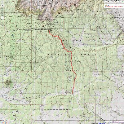
Cedar Ranch Trailhead to the North Kaibab Trailhead
Total AZT miles = AZT 625.6 at Cedar Ranch TH to 717.4 at the North Kaibab TH = 91.8 miles
June 5 - 11, 2017
Text and photos
© copyright by Rob Jones
 |
Co-participants: Solo hike by Rob (Wild Vagabond)
Total Trail Miles –> 91.8
camera: Panasonic DMC-ZS19

|
|---|
Glow Horses, Day 2
(Click the image for the full-size image)
|
|---|
|

|
|---|
The AZT, Day 2
(Click the image for the full-size image)
|
|---|
|

|
|---|
Morning Light on Day 4
(Click the image for the full-size image)
|
|---|
|

|
|---|
Western Tanager, Day 4
(Click the image for the full-size image)
|
|---|
|

|
|---|
Cow Elk, Day 4
(Click the image for the full-size image)
|
|---|
|

|
|---|
Lupine Morning, Day 6
(Click the image for the full-size image)
|
|---|
|
"Between every two pines is a doorway to a
new world". - John Muir
Overview: I backpacked from the Cedar Ranch Trailhead (TH) to the
South Kaibab TH in the main part of this trip. Previously, I hiked the AZT via the South and North Kaibab Trails
through Grand Canyon National Park.
So, as of this report, I've hiked from Oracle to the North Kaibab TH, a distance of AZT mile 200.8
to 717.4 = 516.6 miles, or 64% of the 800 miles from the Mexico to the Utah border.
Counting AZT miles from the Mexico border (AZT mile 0) to the Arizona-Utah
border (AZT mile 800), the AZT is 800 trail miles long.
See all the sections I have hiked on the AZT by clicking on this link to
all WV trip reports about hiking the Arizona Trail.
The Maps: To create the maps you see in this report, I downloaded the
GPS tracks from the ATA (Arizona Trail Association) site and created a map using gpsvisualizer, then captured
a view of the map for you to use. Some of the features mentioned in this report are not on the maps and many
of the features depicted on the maps are not mentioned in the report. I hope you find them useful nevertheless.
The sections as created by the ATA do not exactly correspond to the sections I describe, yet you'll get the
lay of the land from the maps.
Preliminary: A dark swirling cloud of dust chases and occasionally
envelopes Kathleen and me riding in the Subie Subaru placing water caches along the desiccated sections of
the AZT, Arizona Trail. With water reports far from current and the distances long between potential water
sources, it's prudent to cache some water.
Amazingly, as we dust to Lockwood Tank, we encounter over 50 mountain bike
riders from a middle school in Santa Barbara, riding between The Canyon and Sedona. Wonderful. It's so
refreshing to see young people exploring via muscle power rather than the Eaarth destroying ATVs or addicted
to electronic cocaine.
We're encouraged and thrilled to see a virtual lake at Russell Tank; so
grand that a few people are catching planted trout there.
It's a refreshing place for lunch under a stately Ponderosa Pine before
continuing to Grandview Lookout to place the last cache.


|
|---|
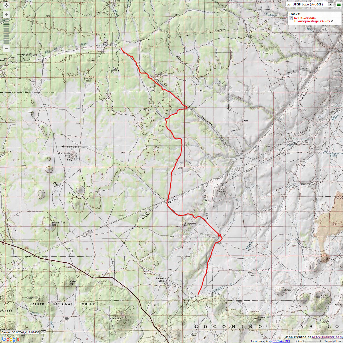
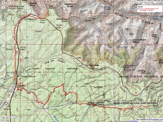
Map - AZT from Cedar Ranch TH to the Moqui Stage Stop, 24.5 miles, Passage 35
(Click the image to see the map)
|
|---|
|
Photos: Day 1 of the AZT 2017, Part 2
Day 1: AZT Association. AZT 625.6 to 627.7:
Cedar Ranch Trailhead, and out 2.1 miles. Camp @ 6360'.
Tim Wilson and I get out of his shuttle jeep at the Cedar Ranch TH
and, wow, there is Wendy L. of the Arizona Trail Association (ATA; see the links section near the end
of this report), and a happy group of young bike riders eating tacos at the TH. Coincidences abound.
These young AZT riders are experiencing a ride from the Peaks (San Francisco Mountain) to The Canyon.
Marvelous! The Seeds of Stewardship Program is an Arizona Trail Association venture to involve youth
from AZT gateway communities in experience, education, and service learning. With careful mentoring by
Sabrina of the ATA, these young stewards tell me they are having a "bodacious!" experience on the AZT.
Thanks to all of you who support the ATA and these young stewards. When you are connected to an area,
you protect and care for it.
Earlier, Tim meets me at the BIC (Backcountry Information Center) in
Grand Canyon National Park at 6 p.m. and shuttles me here.
After a quick catch-up, I say my goodbyes to Wendy and group and Tim
and walk two miles of the lengthy jaunt to Lockwood Tank before dark drops in and it's time to camp.
The distant hulks of the San Francisco Peaks can be seen as the nearly
full moon glows above my hasty yet excellent camp amidst a rare clutch of junipers. The ranchers and
others call the juniper "cedars," although the two are not related. A lone bat circles the TarpTent a
few times before silently flittering off in pursuit of crepuscular insects. It's an absolute silence out
here on night one of AZT 2017, Part 2. It's well past hiker midnight, 9 p.m., as I slip into the cuddly Marmot bag.
Egg salad sandwich, ramen soup, and a banana.
Photos: Day 2 of the AZT 2017, Part 2
Day 2: Arrowhead. To Lockwood Tank. To AZT 643.9:
16.2 miles. Camp @ 6390'.
The sleek Babbitt Ranch horses glow in the first light of day.
They snort at me then ignore me and go back to grazing. Lovely hay burners.
I'm on the trail by 5:30 a.m., getting in some miles before the
solar load bakes me. The low angle light adds a warm relief to the open grasslands.
Climbing a few hundred feet takes me into the pygmy forest of
Pinyon-juniper where I take a break in the shade, then unfurl the umbrella. It's all of 7:30 in
the morning. The San Francisco Peaks and cinder cone field punctuate the skyline at times, although
there's a haze from controlled (or uncontrolled?) burns.
As my feet call for break #2, I plop the pack nearly onto a mostly
finished arrowhead. Wow, this is the place. Someone else found this an excellent rest stop, and
apparently a place to create.
With the course turning into a slog, I locate another enveloping
juniper for rest #3 after about 11 miles of hiking. Natural quiet with (regrettably) almost no breeze,
and the buzz of the occasional fly.
The young AZT Seeds of Stewardship riders and I make it to a low rise
overlooking Upper Lockwood Tank (dry) for lunch. They have surged ahead and now they're sprawled under
a Pinyon Pine enjoying the shade. I find a spot overlooking the tank area and do the same.
The wind comes up so I furl the umbrella and continue to Lockwood Tank.
Wandering in search of a camp with shade and a relatively flat tent
site, I encounter a dilapidated ranch building and a very scenic outhouse, without any walls or door.
The vistas are "Yuge!" from this toilet (a word overused by our coprolalic "leader").
I lug up a bucket of water from Lockwood Tank to the knoll above the
ranch works, and enjoy a cool and refreshing bath. This helps ease the exhaustion until I discover that
the hiking pole I collapsed so that I could easily carry my trusty umbrella is jammed and won't extend.
No big deal except that it is one of the tent poles. After a prolonged struggle, I give up and make do
with a shorter pole. A tilting TarpTent is the result.
I nap awhile until the blazing sun slips low under the tree branches
and bakes me from the tent.
Lasagna with orzo and green beans and tvp (textured vegetable protein);
potato soup. Wasabi infused baked seaweed snack.
|
|---|
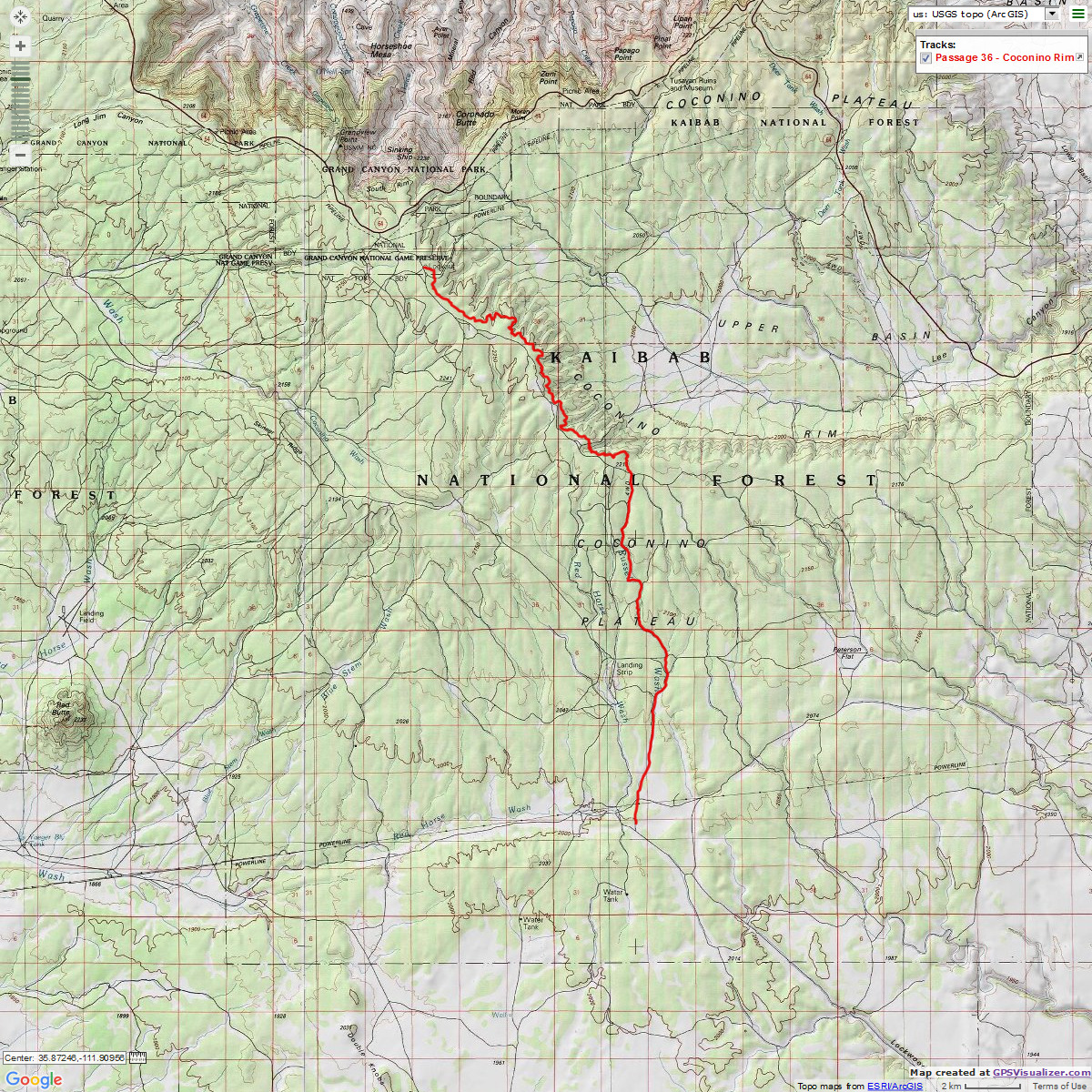
Map - AZT - from the Moqui Stage Stop to Grandview Lookout, 18 miles, Passage 36
(Click the image to see the map)
|
|---|
|
Photos: Day 3 of the AZT 2017, Part 2
Day 3: Swimming Hole/Kaibab Refreshment. To North Russell Tank.
To AZT 656.9:
13.0 miles. Camp @ 7080'.
Refreshingly, the AZT delves into the pygmy forest as soon as it crosses
into the Kaibab National Forest. The Babbits are wonderful to grant such access to the AZT, and I'm thrilled
to be back on public land. The royal purple of the dwarf Larkspur pop vivid in the morning light.
I start out wearing gloves as the cold air flows down the drainage toward
Lockwood Tank. Now, I'm relishing in the dappled shade provided by the Pinyon-juniper, or pygmy, forest.
I feel happy to have public land dirt under my boots as I ramble across the Kaibab Limestone dirt and rocks
on the Kaibab NF.
I stop for a foot break, snack, and water refill at the remnants of the
Moqui Stage Stop. Lovely. The midget bus jockeys shepherding the young ATA stewards have a flat jaw water
pump pliers, and it takes three of us to wrestle the hiking pole apart. It works.
A bit farther and a slight increase in elevation and I notice P-pines
(Ponderosa Pines). The scent of vanilla goodness wafts from the warm pines, an identifying odor of the
Colorado Plateau. As one hikes the AZT, one goes through the Life Zones outlined by C. Hart Merriam. This is
akin to hiking dramatic elevation (such as on the San Francisco Peaks) and climbing through the reverse of
Merriam's Zones: (1) Alpine, (2) Sub-alpine, (3) Hudsonian or Spruce, (4) Canadian, (5) Neutral or Pine,
(6) Pińon, and (7) Desert.
See a bit about C. Hart Merriam and his Life Zones here.
An Osprey rows past in the winds over North Russell Tank. Clearly, there's
lots of water, and fish, remaining in this tank.
I enjoy a bucket bath and a short nap before: eggs and orzo with tvp; pad
thai noodles; wasabi roasted seaweed snack.
Photos: Day 4 of the AZT 2017, Part 2
Day 4: It's a Grand View - Coconino Rim. To Grandview Lookout. AZT 668.2:
11.3 miles. Camp @ 7530'.
The huge coatrack is covered in velvet and anchored to the head of the
bull Elk speeding away from me through the seemingly impenetrable oak thicket. No issues for Mr. Elk.
The route climbs to, then along the edge, yet below the forest roads,
of the Coconino Rim, where I get a first glimpse of The Canyon, a peek of the North Rim escarpment. Gorgeous.
This is the most difficult of the sections in this trip because the trail
bobs through tiny drainages, sometimes larger ones, in the quest to stay just off the crest of the rim and
sort-of contour along. It's a relative "more difficult" however. It levels as it goes West.
As I go in search of the wildlife guzzler tank, I hear the corporate
welfare intrusive drone of the air tour terrorists (tour helicopters and planes). Horrid! They will be
even worse later today.
The orange fluffball zooms past just above the ground, then flashes more
yellow and tangerine as it stops in an oak clump. Western Tanager. He displays nicely until his drab
mate comes along to tell him to get a move on, at which time they undulate off together.
The wind starts to moan, and this enables me to walk within photo distance
of a cow Elk. And, it keeps me from climbing to the top of the swaying Grandview Lookout Tower, yikes.
I locate my cache and attempt to find a shady site where the wind is but
a murmur.
I'm back for more exploring of the Lookout when I again meet the young
stewards on their Arizona Trail Association sponsored ride to The Canyon, and Wendy invites me to join
this energetic group for tacos. They are yummy and the conversations are most excellent. About time to
go find camp before dark-thirty, the sunset paints the sky a rumpled swirl of reds and oranges. Deluxe!
As noted, tacos and hot cocoa with the young stewards of the Arizona
Trail Association.
|
|---|
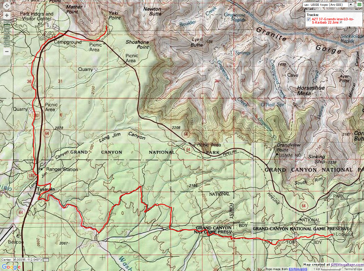
Map - AZT - Grandview Lookout to the South Kaibab TH, 22.5 miles, Passage 37
(Click the image to see the map)
|
|---|
|
Photos: Day 5 of the AZT 2017, Part 2
Day 5: Tankless. To FR 9122E. AZT 678.1:
9.9 miles. Camp @ 6870'.
The erratic wind brings the subtle aroma of P-pines and the background
roar of fast moving air. This keeps the temperature down yet difficult to keep on the hat. I stop at
Watson Tank to the tune of "Dust in your teeth, all you have is dust in your teeth" from an Idaho country
song of the same name. Today it's a dust bowl. Tankless.
The trail from Grandview ends in a road near Watson Tank, and who should
appear, French tourists following the GPS in their van. No, this is not the short way to Grandview. They
scrape off some of their rental van on the Kaibab Limestone and head back toward Tusayan.
Continuing on, there's a bit of road walking to Upper Ten-X Tank, which is
also tankless, dust in your teeth.
The wind and solar load continue unabated into the early afternoon. I
unfurl the umbrella and intermittently fight the wind for possession of it.
I'm early to the water cache, and now I'm lounging under swaying P-pines
enjoying the shade and the drift into evening on Day 5 of the AZT 2017 Part 2.
Maverik hikes in to chat, section hiking from the North border. We talk
about issues with good water on the AZT and also the significant water crossing problems hikers are having
in the Sierra area on the PCT (Pacific Crest Trail). Maverik is the only AZT hiker I encounter since Cedar Ranch TH.
A trio of mule deer nose over the rise, then scatter when they see me.
There's a pink wildfire tinge to the low clouds at sunset.
Couscous and orzo with beef and bullion, curry, parsley, green onions,
corn, and garlic; wakame soup.
Photos: Day 6 of the AZT 2017, Part 2
Day 6: The Canyon Edge. To the South Kaibab TH:
12.5 miles. AZT 690.6.
The solitary Elk whistle breaks the pre-dawn stillness of morning
6 on the AZT 2017 Part 2. Haunting.
Reclining in the deep needles from the stately P-pines and amidst
lavender Lupine, it's cool enough that a down jacket feels just right. It's a breakfast of couscous,
raisins, milk and protein powder, and a full 4 cups of mocha coffee as the early light spills through
the Ponderosa. Yummy.
The route winds ever so slightly down grade to the terrorist harboring
burg of Tusayan before crossing under Hwy 64; almost to The Canyon. Bloated carbon trumpdom selfish
Eaarth-wrecking winnehogos above, hiker below. Who sees and senses the Eaarth and its parts more,
and more completely? Tin can tourists? Air tour terrorists? To the Tusayan town council, the
high-decibel whine of aircraft is the sound of money. To people of the Eaarth, it's the sound of
global warming and corporate welfare. The welfare part is the theft of a precious public resource
(natural quiet, especially in the Park established for its preservation) and the "contribution" of
air pollution and visual disruption (socialize the loss, privatize the gain). And, an unpresidential
"president" takes us out of the Global Climate Change discussion, instead tearing apart safeguards
for clean air and water (concurrent with destroying what health insurance people have),
and giving our precious public land to his corporate masters, while setting
in motion the next economic collapse and rape of the middle class by destroying wall street regulations.
I meet Crocs, an AZT hiker, on the paved portion of this final leg
to The Canyon and we talk GC for half an hour.
Then, it's a fine walk past Mather Campground and onto a fire road
where smoke swirls North, across the route, from the remains of a recent controlled burn. A final
crossing of Hwy 64 and soon, there's The Canyon! Yowee! A quick photo at the South Kaibab TH and
the NPS shuttle bus arrives to ferry me back to the Subie Subaru parked at the BIC, Backcountry
Information Center, concluding this continuous segment from Oracle to the North Kaibab TH
(AZT mile 200.8 to 717.4 = 516.6 miles).
THE Canyon! South Kaibab TH to the North Kaibab TH:
Author's note: This report officially ends counting this
segment of the AZT to the North Kaibab TH, at AZT 717.4.
I've hiked The AZT/South-North Kaibab
several times, one of which can be seen here (click for the full Rimster trip report).
Photos: Scenic Toilets of the AZT 2017, Part 2

|
|---|
Looking for All Wilderness Vagabond trip reports about hiking the Arizona Trail?
Click the image to go to All WV reports about The AZT, Arizona Trail
|
|---|
|

Links and books:
Arizona Trail Association - trail and water conditions; maps of some of this hike
Link to all WV reports about hiking the AZT (same link as obtained by clicking on the above image)
How to use alum to clarify water prior to treating it.
Bill McKibben – suggested books include: Maybe One, Eaarth, The End of Nature
Related Sites:
Scenic Toilets of Inner Earth:
Scenic Scatology of the Wilderness Vagabond
We Are Breeding Ourselves to Extinction (click here for full article, pdf)
More Truth Than Joke:

|
|---|
with trump-you all lose all
(Click the image for the full-size image)
|
|---|
|

|
|---|
air is shared
(Click the image for the full-size image)
|
|---|
|

|
|---|
MEGA - Make Eaarth Great Again
(Click the image for the full-size image)
|
|---|
|

|
|---|
Innocent children hurt by their own president, part 1
(Click the image for the full-size image)
|
|---|
|

|
|---|
Innocent children hurt by their own president, part 2
(Click the image for the answer)
|
|---|
|

|
|---|
Innocent children hurt by their own president, part 3
(Click the image for the full-size image)
|
|---|
|

|
|---|
Innocent children hurt by their own president, part 4
(Click the image for the full-size image)
|
|---|
|
"What luck for the rulers that
men do not think". - Adolph Hitler