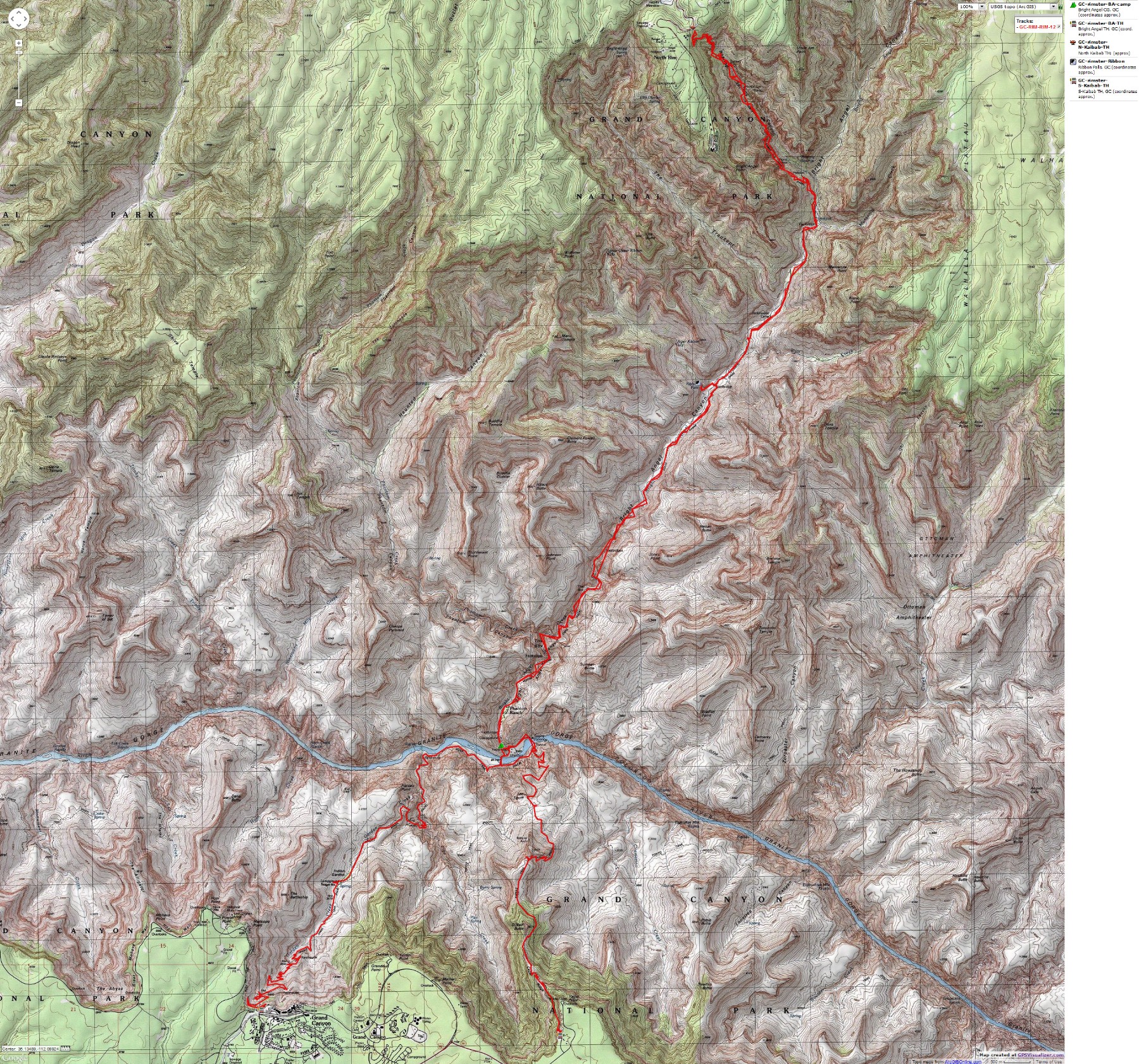
Rimster:
Grand Canyon Corridor Cruise / Rim - to - Rim - to - Rim in Grand Canyon NP / 
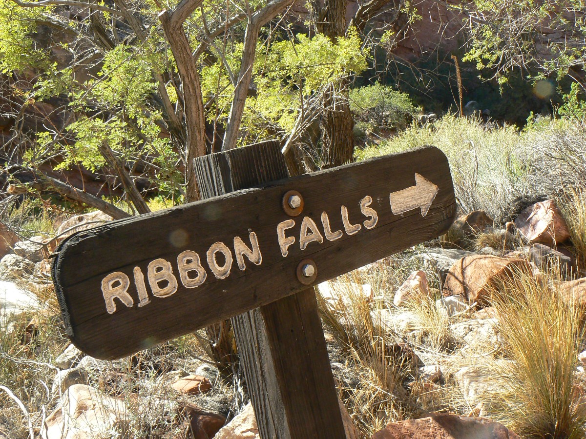
South Kaibab Trail / Bright Angel CG / North Kaibab Trail / Ribbon Falls / Cottonwood CG / North Rim / Bright Angel Trail
 

October 12 - 16, 2012

Text © copyright by Rob Jones and Photos © copyright by Rob

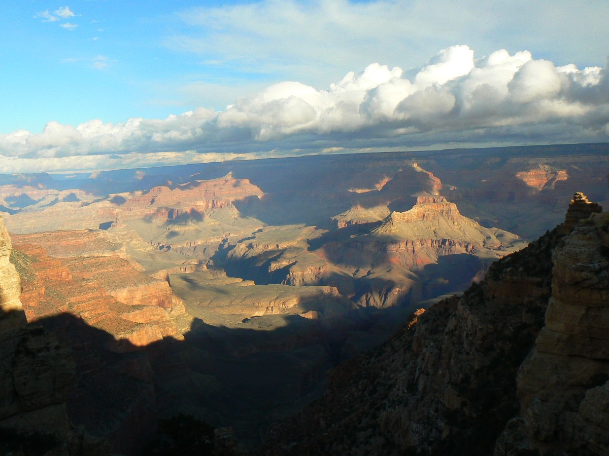
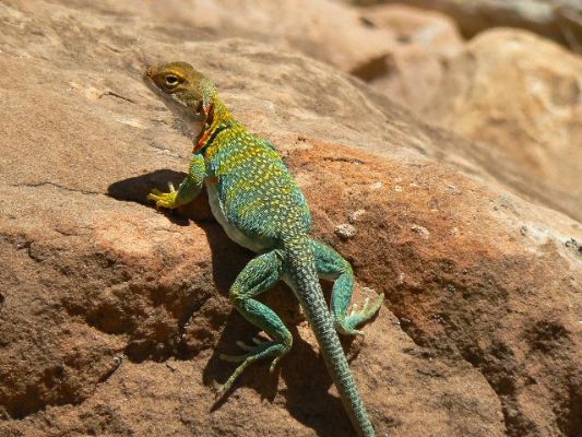
Down the South Kaibab - Day 1
(Click the image for the full-size image)
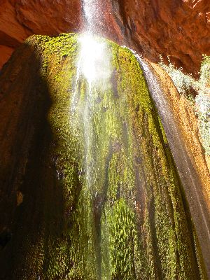
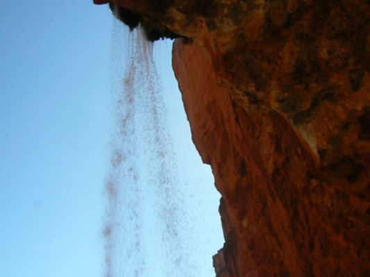
From behind Ribbon Falls - Day 2
(Click the image for the full-size image)

(There are - photos embedded in the trip narrative.)

Co-Adventurer: Kathleen Jones

ERM - Energy Required Miles. A mile is added for every 500' elevation gain or loss. It's a very serviceable method of estimating energy required miles.

Total trip - (per my GPS) 48.4 miles and total ERM = 92.3.

Camera - Panasonic DMC-FZ7

Movies: You may wish to begin downloading the movies as you peruse the report - this way, they will pop up to view (and you won't be waiting). The movies in the below list are also seen interspersed in the text. The movies are:

Movie of Ribbon Falls - scanning - 5.8mb.

Movie of Ribbon Falls - stationary - 1.5mb.

Movie from behind Ribbon Falls - stationary - 1.4mb.

Movie from behind Ribbon Falls - scanning - 4.8mb.

Movie of burble below Ribbon Falls - 1.4mb.

Movie of Ribbon Falls - 5.8mb
Movie of Ribbon Falls Day 2 - 5.8mb
(Click the image to see the short video - 6mb)

Movie of Ribbon Falls - stationary - 1.5mb
Movie of Ribbon Falls - stationary - Day 2 - 1.5mb
(Click the image to see the short video - 6mb)

Map - GC: Corridor Cruise; 48 miles; 2012
(Click the image to see the map)

for a full-resolution map, click here. Caution - do not use this map or gps track for navigating the route.

     Overview: Kathleen and I hiked an ethical (displaying trail courtesy, unlike rim-to-rim (R2) runners or fast walkers - see data below), rim-to-rim-to-rim backpack on the Grand Canyon corridor trails. South Kaibab to North Kaibab to Bright Angel. Yes, it's them there data, not your opinion, that counts. Data show (how come so many use "data" as a singular, data are, datum is; it's certainly not "datums") that R2s rarely exhibit trail courtesy and that courtesy is nearly completely absent among trail runners (that is, 0% of runners we encountered were courteous).

     90% - Backpackers exhibiting trail courtesy - very good.
     2.5% - (5 out of 200) R2 yield to uphill hikers - abysmal.
     O% - trail runners yield to uphill hikers - bushco winner.

GC Rimster - Day 1

Click thumbnail to see full size image
wgc-rimster-2012 day1-1  Kathleen and friend on Kaibab Express bus.jpg (190430 bytes)

wgc-rimster-2012 day1-1 Kathleen and friend on Kaibab Express bus.jpg

wgc-rimster-2012 day1-2  twist and turn.jpg (441004 bytes)

wgc-rimster-2012 day1-2 twist and turn.jpg

wgc-rimster-2012 day1-3  ooh and ahh.jpg (260654 bytes)

wgc-rimster-2012 day1-3 ooh and ahh.jpg

wgc-rimster-2012 day1-4  rain coming.jpg (285238 bytes)

wgc-rimster-2012 day1-4 rain coming.jpg

wgc-rimster-2012 day1-5  boat beach in rain.jpg (451777 bytes)

wgc-rimster-2012 day1-5 boat beach in rain.jpg

wgc-rimster-2012 day1-6  by a nose.jpg (172424 bytes)

wgc-rimster-2012 day1-6 by a nose.jpg

wgc-rimster-2012 day1-7  by a nose.jpg (195252 bytes)

wgc-rimster-2012 day1-7 by a nose.jpg

wgc-rimster-2012 day1-8  window to outside.jpg (536873 bytes)

wgc-rimster-2012 day1-8 window to outside.jpg

wgc-rimster-2012 day1-9  black bridge view.jpg (343866 bytes)

wgc-rimster-2012 day1-9 black bridge view.jpg

wgc-rimster-2012 day1-10  sewage and piano alley.jpg (532749 bytes)

wgc-rimster-2012 day1-10 sewage and piano alley.jpg

wgc-rimster-2012 day1-11  tunnel view.jpg (410614 bytes)

wgc-rimster-2012 day1-11 tunnel view.jpg

wgc-rimster-2012 day1-12  river trail view.jpg (494957 bytes)

wgc-rimster-2012 day1-12 river trail view.jpg

     Day 1: Damp Angel: To Bright Angel (BA) CG. 7.2 miles per GPS. NPS miles = 7.0. Elevation loss of 4570 and gain of 350'. ERM = 17.0. Camp at 2500'.
     The cool rain sweeps across the Tonto Platform and leaks through my partially-open jacket to dampen my camera case. It plasters wet pants to my legs and sends a dull ache through my arthritic fingers. Argh. Rain squalls have pursued us throughout the day as we ease down the glorious South Kaibab Trail.
     The storm passes and we hike awhile before the next one arrives. We can predict the arrival of the squalls because the temples and buttes to the West fade into the storm bulk, disappearing into a gray mass not long before the front hits us.... The rain clears the air and brightens the colors of rocks made by time.
     As we corkscrew into basement rocks, approaching the Black Bridge, it rains seriously, and we hide out in the tunnel to the bridge, and then under an overhang, before strolling to the camp and setting up the tent. As soon as the tent is up, the rain stops.
     I walk the river trail between bridges, then Kathleen and I walk to the cantina and eat a leisurely lunch (our lunch).
     The day started with a huge bull elk eyeballing us as we drive across the Kaibab NF. He's sniffing for cow elk, so pays us little attention. Big 
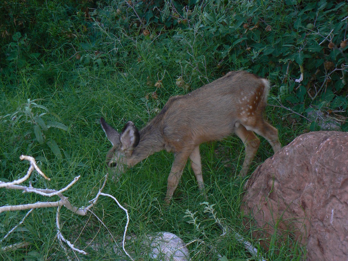
buck deer flit like ghosts in the Ponderosa. There's not enough light to get any photos.

     The mnemonic goes like this (read down, use first letter of starting word as a reminder - from the rim, down; with mixed layers near The River that do not follow this convention):

    Know - Kaibab Limestone
    The - Toroweap Formation
    Canyon's - Coconino SS
    History - Hermit Shale
    Study - Supai Group (including the Esplanade)
    Rocks - Redwall Limestone
    Made - Mauv Limestone
    By - Bright Angel Shale
    Time - Tapeats SS

    Know The Canyon's History, Study Rocks Made By Time.

Movie from behind Ribbon Falls - stationary - 1.4mb
Movie from behind Ribbon Falls - stationary - Day 2 - 1.4mb
(Click the image to see the short video - 6mb)

GC Rimster Day 2

Click thumbnail to see full size image
wgc-rimster-2012 day2-1  tent at morning.jpg (150678 bytes)

wgc-rimster-2012 day2-1 tent at morning.jpg

wgc-rimster-2012 day2-2  on the North Kaibab.jpg (465730 bytes)

wgc-rimster-2012 day2-2 on the North Kaibab.jpg

wgc-rimster-2012 day2-3  Ribbon Falls.jpg (266948 bytes)

wgc-rimster-2012 day2-3 Ribbon Falls.jpg

wgc-rimster-2012 day2-4  Ribbon Falls.jpg (243305 bytes)

wgc-rimster-2012 day2-4 Ribbon Falls.jpg

wgc-rimster-2012 day2-5  Ribbon Falls.jpg (210830 bytes)

wgc-rimster-2012 day2-5 Ribbon Falls.jpg

wgc-rimster-2012 day2-6  Ribbon Falls.jpg (366091 bytes)

wgc-rimster-2012 day2-6 Ribbon Falls.jpg

wgc-rimster-2012 day2-7  Ribbon Falls.jpg (252116 bytes)

wgc-rimster-2012 day2-7 Ribbon Falls.jpg

wgc-rimster-2012 day2-8 this way Ribbon Falls.jpg (572971 bytes)

wgc-rimster-2012 day2-8 this way Ribbon Falls.jpg

wgc-rimster-2012 day2-9  Cottonwood NB.jpg (149900 bytes)

wgc-rimster-2012 day2-9 Cottonwood NB.jpg

wgc-rimster-2012 day2-10  Cottonwood NB.jpg (183200 bytes)

wgc-rimster-2012 day2-10 Cottonwood NB.jpg

wgc-rimster-2012 day2-11  ancient stuff.jpg (186609 bytes)

wgc-rimster-2012 day2-11 ancient stuff.jpg

wgc-rimster-2012 day2-12  Sunset Cottonwood.jpg (185206 bytes)

wgc-rimster-2012 day2-12 Sunset Cottonwood.jpg

wgc-rimster-2012 day2-13  Sunset Cottonwood.jpg (237892 bytes)

wgc-rimster-2012 day2-13 Sunset Cottonwood.jpg

wgc-rimster-2012 day2-14  Sunset Cottonwood.jpg (169594 bytes)

wgc-rimster-2012 day2-14 Sunset Cottonwood.jpg

wgc-rimster-2012 day2-15  Sunset Cottonwood.jpg (214186 bytes)

wgc-rimster-2012 day2-15 Sunset Cottonwood.jpg

Movie from behind Ribbon Falls - scanning - 4.8mb
Movie from behind Ribbon Falls - scanning - Day 2 - 4.8mb
(Click the image to see the short video - 6mb)

     Day 2: Cottonwood Clog: To Ribbon Falls and Cottonwood CG. GPS = 9.0. NPS = 7.2 + distance to Ribbon Falls. ERM = 13.5. Camp at 4000'.
     Another phalanx of unyielding, republican-behaving (freedom is where my "rights" get priority over all others) trail runners and rim-to-rimmers (R2) nearly collides with me as I hike up Canyon. Is there any thought about carrying capacity or preserving natural value? No, just look at the population policies of the U.S., indeed, most of the world. Horrid, discourteous, louts and scum. I am relieved to round a corner in The Box, the basement rock slot of BA Creek, and not see R2s as they ignore all trail conventions and abuse the park resources too.
     I keep track for awhile: out of 200 that I pass, only 5 R2 yield to uphill hikers (2.5% courtesy score, abysmal). No runners yield at any time (0% courtesy score, republican). It's certainly difficult to enjoy the trail and its aura with this overpopulation of self-absorbed, self-important, selfish narcissists. A few of these misfits is an irritation. Hundreds produces a Canyon catastrophe. Litter, noise, clogged trails and facilities, clothing discarded, and a strain on search and rescue and other resources they are not funding. Backpackers comport themselves more ethically - demonstrating trail courtesy about 90% of the time. Repulsicans of the modern day vote against funding government services about 100% of the time. I say, give these R2 a sacrifice trail, one on the North and one on the South rim. How about the Uncle Jim on the North, and the Abyss on the South. It's only a vestige of my concern for their welfare that I say - relegate them to one trail on each of the rims - for their and the Canyon's best interests.
     Last night, Bill V. had warned us to wait until at least 9a before hiking to avoid the R2 trail terrorists. We do so, and Pete, surveying the trail, tells us he has already counted over 200 R2 and that the Park is concerned about this "emerging" issue. Emerging?! It's a full blown bushco!
     After the serpentine swirl through the narrow section past 
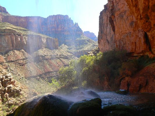
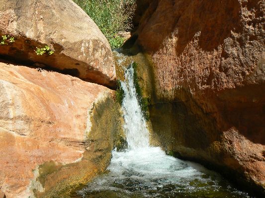
Phantom Creek and beyond, K and I pause to visit Ribbon Falls. Gorgeous. Water and deposition in action. Then, the short climb to Cottonwood Camp, where we enjoy a relaxing afternoon, bath, view of the tiny natural bridge, and a general wander of the area prior to enjoying sunset on rocks made by time. A Ruffous-sided Towhee kicks into the area and nearly explores into the open tent in his search for bugs. The BA Creek forms a pleasant background to the slightly cool evening.

Movie of burble below Ribbon Falls - 1.4mb
Movie of burble below Ribbon Falls - Day 2 - 1.4mb
(Click the image to see the short video - 6mb)

GC Rimster Day 3

Click thumbnail to see full size image
wgc-rimster-2012 day3-1  early a.m.  Roaring Springs.jpg (131982 bytes)

wgc-rimster-2012 day3-1 early a.m. Roaring Springs.jpg

wgc-rimster-2012 day3-2  Roaring.jpg (121031 bytes)

wgc-rimster-2012 day3-2 Roaring.jpg

wgc-rimster-2012 day3-3  at the North Rim.jpg (388060 bytes)

wgc-rimster-2012 day3-3 at the North Rim.jpg

wgc-rimster-2012 day3-4  Fall on the N Kaibab.jpg (713285 bytes)

wgc-rimster-2012 day3-4 Fall on the N Kaibab.jpg

wgc-rimster-2012 day3-5  Down from Supai Tunnel.jpg (331860 bytes)

wgc-rimster-2012 day3-5 Down from Supai Tunnel.jpg

wgc-rimster-2012 day3-6  Redwall Bridge.jpg (462642 bytes)

wgc-rimster-2012 day3-6 Redwall Bridge.jpg

wgc-rimster-2012 day3-7  Roaring Springs.jpg (282464 bytes)

wgc-rimster-2012 day3-7 Roaring Springs.jpg

wgc-rimster-2012 day3-8  Roaring Springs.jpg (271556 bytes)

wgc-rimster-2012 day3-8 Roaring Springs.jpg

wgc-rimster-2012 day3-9  Night visitor.jpg (331195 bytes)

wgc-rimster-2012 day3-9 Night visitor.jpg

     Day 3: Rimster: To North Rim and Back. GPS = 13.1 (30.9). NPS miles = 13.6. ERM = 31.2. Camp at 4000'.
     After nearly seven miles of over 4000' of elevation gain, I'm passing golden glow Aspens and fading color oaks and maples and almost to the quite cold North Rim. Yes. Rimster. (4 hrs up; 3.5 down) I'm at the North Kaibab TH, with goosebumps on my arms. A quick snack, a refill of the platypus, and I'm sliding back into The Canyon, headed for a leisurely rim-to-rim-to-rim. Yet, of course there's a stay at Cottonwood and again at Bright Angel CG before logging that last rimster on Day 5, and this is a good thing, a more ethical and harmonious path than those annoying, callous rim trotters.
     Down, through the Kaibab, the Toroweap, the white cliff of Coconino SS, into Hermit Shale and the Supai Tunnel, where I meet George Vargas and C. J. Malcolm of SAR, George a volunteer and C. J. the supervisor of SAR for the North Rim.
     Down, into the walkways of Redwall notched into this mass of limestone, running into the Muav and aural-visual splendor of Roaring Springs.
     Soon, the new scenic outhouse at the pumphouse residence rolls into view. Scenic toilet! Lovely. I'm feeling a bit wrung out, so I stop for a foot, water, and third snack break. It's a bit hot as I stroll the last of the distance to Cottonwood CG, where K has been day hiking and recovering. Back in camp by 3:30p, it's been a 7-hour jaunt, counting breaks. Now, a bath before local sunset sounds excellent. Then, as the small herd of Deer Mice scamper, the light fades from Canyon walls and the dining room lights are switched on at the North Rim Lodge, followed by Orion and friends.

GC Rimster Day 4

Click thumbnail to see full size image
wgc-rimster-2012 day4-1  morning light.jpg (294673 bytes)

wgc-rimster-2012 day4-1 morning light.jpg

wgc-rimster-2012 day4-2  Ribbon Falls - distant.jpg (124255 bytes)

wgc-rimster-2012 day4-2 Ribbon Falls - distant.jpg

wgc-rimster-2012 day4-3  Along the  N. Kaibab.jpg (294617 bytes)

wgc-rimster-2012 day4-3 Along the N. Kaibab.jpg

wgc-rimster-2012 day4-4  Along the  N. Kaibab.jpg (315862 bytes)

wgc-rimster-2012 day4-4 Along the N. Kaibab.jpg

wgc-rimster-2012 day4-5  Faulting.jpg (427375 bytes)

wgc-rimster-2012 day4-5 Faulting.jpg

wgc-rimster-2012 day4-6  Historic line.jpg (377064 bytes)

wgc-rimster-2012 day4-6 Historic line.jpg

wgc-rimster-2012 day4-7  in the BA Box.jpg (252500 bytes)

wgc-rimster-2012 day4-7 in the BA Box.jpg

wgc-rimster-2012 day4-8  in the BA Box.jpg (137574 bytes)

wgc-rimster-2012 day4-8 in the BA Box.jpg

wgc-rimster-2012 day4-9  leafy.jpg (322637 bytes)

wgc-rimster-2012 day4-9 leafy.jpg

wgc-rimster-2012 day4-10  Phantom.jpg (187675 bytes)

wgc-rimster-2012 day4-10 Phantom.jpg

wgc-rimster-2012 day4-11  BA delta view.jpg (346935 bytes)

wgc-rimster-2012 day4-11 BA delta view.jpg

wgc-rimster-2012 day4-12  Dragonfly.jpg (152466 bytes)

wgc-rimster-2012 day4-12 Dragonfly.jpg

wgc-rimster-2012 day4-13  BA Creek.jpg (559072 bytes)

wgc-rimster-2012 day4-13 BA Creek.jpg

wgc-rimster-2012 day4-14  Historic Line.jpg (469232 bytes)

wgc-rimster-2012 day4-14 Historic Line.jpg

wgc-rimster-2012 day4-15 another night visitor.jpg (450339 bytes)

wgc-rimster-2012 day4-15 another night visitor.jpg

     Day 4: BA Return: To BA CG. GPS = 7.6 (38.8 total). NPS miles = 7.2. ERM = 10.6. Camp at 2500'.
     The cool air envelopes us as we enter the basement rock gorge (the Box) of BA Creek. Luscious. We're up early and touring the North Kaibab Trail long before sunlight reaches the Cottonwood scenic toilet. Although much more subdued in number, the trail runners and rim hikers are no more considerate, that is, not considerate at all. Horrid.
     Passing the mouth of Phantom Creek, the sunlight leaks in, yet we're almost to BA. A beer in the cantina and a wander of the river trail and an early evening search for fox and deer is quite productive, although there is insufficient light for a good photo. Bil V. again comes by to see if we survived the hoard of trail runners - we have, yet with grumpy dispositions. The lilting loll of BA Creek washes away the grumpiness.

GC Rimster Day 5

Click thumbnail to see full size image
wgc-rimster-2012 day5-1  River glow.jpg (250601 bytes)

wgc-rimster-2012 day5-1 River glow.jpg

wgc-rimster-2012 day5-2  Starting up the BA.jpg (189836 bytes)

wgc-rimster-2012 day5-2 Starting up the BA.jpg

wgc-rimster-2012 day5-3  BA view.jpg (186102 bytes)

wgc-rimster-2012 day5-3 BA view.jpg

wgc-rimster-2012 day5-4  morn. light.jpg (194289 bytes)

wgc-rimster-2012 day5-4 morn. light.jpg

wgc-rimster-2012 day5-5  Almost to IG.jpg (311589 bytes)

wgc-rimster-2012 day5-5 Almost to IG.jpg

wgc-rimster-2012 day5-6  puddle view.jpg (192599 bytes)

wgc-rimster-2012 day5-6 puddle view.jpg

wgc-rimster-2012 day5-7  to IG on Tapeats.jpg (386607 bytes)

wgc-rimster-2012 day5-7 to IG on Tapeats.jpg

wgc-rimster-2012 day5-8  back to Plateau Point.jpg (220222 bytes)

wgc-rimster-2012 day5-8 back to Plateau Point.jpg

wgc-rimster-2012 day5-9  from top of Redwall.jpg (387061 bytes)

wgc-rimster-2012 day5-9 from top of Redwall.jpg

wgc-rimster-2012 day5-10  Supai art.jpg (273028 bytes)

wgc-rimster-2012 day5-10 Supai art.jpg

wgc-rimster-2012 day5-11  Almost on top.jpg (395115 bytes)

wgc-rimster-2012 day5-11 Almost on top.jpg

wgc-rimster-2012 day5-12  one way home.jpg (380268 bytes)

wgc-rimster-2012 day5-12 one way home.jpg

     Day 5: Final Rim: Out BA. GPS = (48.4 total miles). NPS = 9.5. ERM = 20. (Total ascent of 10,880' and descent of 11,038'); ERM total = 92.3.
     Up with Orion, we're finishing the last cookie and cocoa and packing as light replaces billions and billions of stars. We're completing the rimster, hiking out the BA Trail. Still, there are a few r-money runners, who yell "I'm coming through!" rather than observe common trail courtesy. Perhaps, someday soon, he will be elbowing his way past a not-so-gentle mule and we taxpayers will have to pay to have his cheese-grated corpse flown out of our Canyon?
     It's a joy climbing up through basement rocks and the Tapeats SS to Indian Garden, where we loaf awhile in the amphitheater and eat some snacks. Then, up more - almost totally in the shade of big walls today.
     I'm low on energy as we creep past the pictos in the Supai layer, yet delight in the artistry nonetheless. Rimster! Wonderful. We pause at Plaza Bonita to recharge, then head for home.

Scenic Toilets of the GC Rimster 2012

Click thumbnail to see full size image
wgc-rimster-2012 scenic toilet 1  Cottonwood.jpg (171030 bytes)

wgc-rimster-2012 scenic toilet 1 Cottonwood.jpg

wgc-rimster-2012 scenic toilet 2  Pumphouse.jpg (229720 bytes)

wgc-rimster-2012 scenic toilet 2 Pumphouse.jpg

wgc-rimster-2012 scenic toilet 3  Supai Tunnel.jpg (383161 bytes)

wgc-rimster-2012 scenic toilet 3 Supai Tunnel.jpg

wgc-rimster-2012 scenic toilet 4  Pumphouse.jpg (269046 bytes)

wgc-rimster-2012 scenic toilet 4 Pumphouse.jpg

wgc-rimster-2012 scenic toilet 5  Pumphouse.jpg (256380 bytes)

wgc-rimster-2012 scenic toilet 5 Pumphouse.jpg

wgc-rimster-2012 scenic toilet 6  Pumphouse.jpg (235884 bytes)

wgc-rimster-2012 scenic toilet 6 Pumphouse.jpg

wgc-rimster-2012 scenic toilet 7  Pumphouse.jpg (185847 bytes)

wgc-rimster-2012 scenic toilet 7 Pumphouse.jpg

wgc-rimster-2012 scenic toilet 8  Bright Angel.jpg (535549 bytes)

wgc-rimster-2012 scenic toilet 8 Bright Angel.jpg

wgc-rimster-2012 scenic toilet 9  BA.jpg (172429 bytes)

wgc-rimster-2012 scenic toilet 9 BA.jpg

wgc-rimster-2012 scenic toilet 10  Garden Creek near River.jpg (172946 bytes)

wgc-rimster-2012 scenic toilet 10 Garden Creek near River.jpg

wgc-rimster-2012 scenic toilet 11  Indian Garden.jpg (388625 bytes)

wgc-rimster-2012 scenic toilet 11 Indian Garden.jpg

wgc-rimster-2012 scenic toilet 12  3-mile on BA.jpg (311183 bytes)

wgc-rimster-2012 scenic toilet 12 3-mile on BA.jpg

Links:

Maps:

Map - GC: Corridor Cruise; 48 miles; 2012
(Click the image to see the map)

for a full-resolution map, click here. Caution - do not use this map or gps track for navigating the route.

Movies:

Movie of Ribbon Falls - scanning - 5.8mb.

Movie of Ribbon Falls - stationary - 1.5mb.

Movie from behind Ribbon Falls - stationary - 1.4mb.

Movie from behind Ribbon Falls - scanning - 4.8mb.

Movie of burble below Ribbon Falls - 1.4mb.

YouTube versions of videos:

short Ribbon Falls, camera stationary:

view from behind Ribbon Falls

burble below Ribbon Falls:

Ribbon Falls - scan with camera:

Books:

Eaarth : making a life on a tough new planet, McKibben, Bill, Time Books, 2010.

Maybe one : an environmental and personal argument for single-child families, McKibben, Bill, Simon & Schuster, 1998.

The end of nature, McKibben, Bill, Random House, 1989.

A River Runner's Guide to the History of the GRAND CANYON, Crumbo, Kim, JOHNSON BOOKS 1880 South 57th Court, Boulder, Colorado, 80301 1994.

Other WV reports about the Grand Canyon:

Click here or on the Looking Lizard to go to all WV reports about The Grand Canyon

All Wilderness Vagabond trip reports about the Grand Canyon
Looking for All Wilderness Vagabond trip reports about the Grand Canyon?
Click the image to go to All WV reports about The Grand Canyon

Related Links:

Scenic Toilets of Inner Earth

the geology of the Grand Canyon by the NPS

the geology of the Grand Canyon by Bob Ribokas

CCC - Civilian Conservation Corp - in the GC, pdf file, 1.2mb.

More Truth Than Joke:

vote republican
vote republican
(Click the image for the full-size image)

corporate welfare
corporate welfare
(Click the image for the full-size image)

Social Security funding solution

jimmy crow repulsicans
(Click the image for the full-size image)

no climate change debate?
(Click the image for the article - pdf)

r-money is a predatory wall-streeter
(Click the image for full-size image)


Wild Vagabond Main   Trip Report Index   Caveat