JMT, Hiking The Jaunty Juggernaut, The John Muir Trail
Septuagenarian Transnavigation of the JMT
South to North along
the Sierra, Horseshoe Meadows to Happy Isles
244.8 miles (average of 8.7/day)
August 7th to September 6th, 2021
(28 hike days)
Text and photos
© copyright by Rob Jones, Wild Vagabond
 |
Co-adventurers: Zig Sondelski and Rob Jones; assistance by Barry Brenneman and Barbara Boehme
Total Trail Miles –> 244.8 (average of 8.7/day), this includes resupply miles.
Total ERM = 438.8 (Energy Required Miles, see operational definition below), nearly twice the trail miles.

|
|---|
Grouse, Day 18
(Click the image for the full-size image)
|
|---|
|

|
|---|
Kearsarge Sun, Day 8
(Click the image for the full-size image)
|
|---|
|

|
|---|
Banner Pk, Thousand Island Lk, Day 19
(Click the image for the full-size image)
|
|---|
|

|
|---|
Cathedral Pk, Day 26
(Click the image for the full-size image)
|
|---|
|

|
|---|
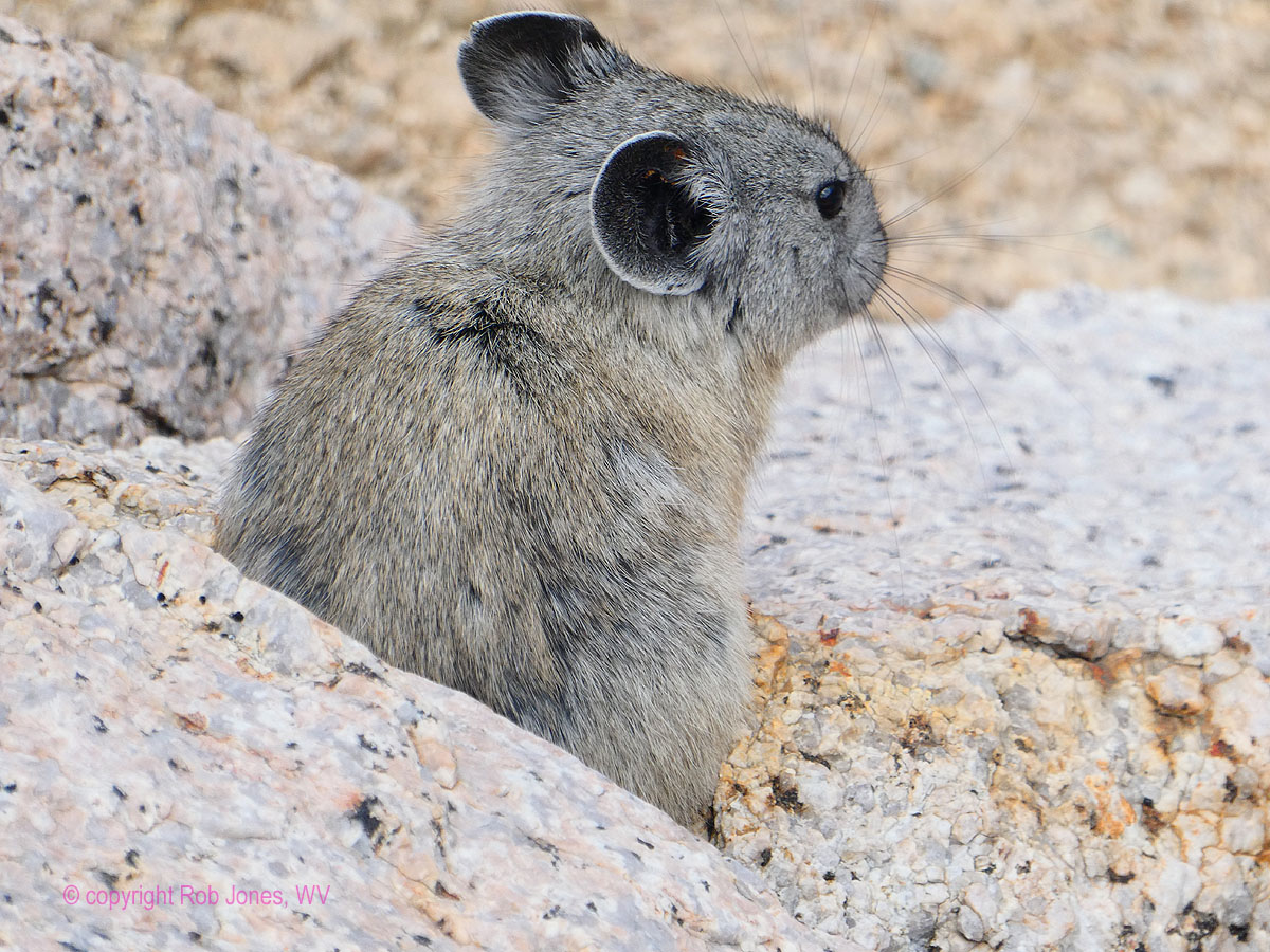
Pika, Day 7
(Click the image for the full-size image)
|
|---|
|

|
|---|
Marmot, Day 12
(Click the image for the full-size image)
|
|---|
|

|
|---|
TarpTent - S of Forester, Day 4
(Click the image for the full-size image)
|
|---|
|

|
|---|
Forester Pass, Day 5
(Click the image for the full-size image)
|
|---|
|

|
|---|
Banner Group, Day 19
(Click the image for the full-size image)
|
|---|
|

|
|---|
Great Western Divide, Day 4
(Click the image for the full-size image)
|
|---|
|

|
|---|
View to S from Forester, Day 5
(Click the image for the full-size image)
|
|---|
|

|
|---|
Zig at Kearsarge Pass, Day 7
(Click the image for the full-size image)
|
|---|
|

|
|---|
from Glen Pass, Day 9
(Click the image for the full-size image)
|
|---|
|

|
|---|
Mather Pass area, Day 11
(Click the image for the full-size image)
|
|---|
|
.

|
|---|
Movie 1: Evolution Basin, Day 14, 23mb
(Click the image to see the video)
|
|---|
|
.

 Map of the route hiked.
This web version from GPS Visualizer can be enlarged, assuming that
it works for you. ----> click here for the GPS visualizer map. Zoom in for a view with contour lines.
Map of the route hiked.
This web version from GPS Visualizer can be enlarged, assuming that
it works for you. ----> click here for the GPS visualizer map. Zoom in for a view with contour lines.
camera: Panasonic DMC-ZS70
Septuagenarian: A person who is 70 years old or between the ages of 70 and 80.
Summary:
This is a long report about our 28 day hike of the Jaunty Juggernaut, the John Muir Trail (JMT),
from Horseshoe Meadows to Happy Isles. We hiked South to North and were refreshed with four resupplies:
at Independence, Muir Trail Ranch, Reds Meadow, and Tuolumne Meadows.
My trail name is Wild Vagabond. Many years ago, I "earned" this trail name in The Grand Canyon,
and brought it with me to subsequent hikes. The website name "wildernessvagabond.com" evolved from the trail name. Zig's trail name
is Zigs, it's a play on zig-zag.
This report contains lots of photos, several videos,
and the text right out of my trail journal - Yowee and enjoy!
ERM = Energy Required Miles. A mile is added for
every 500' elevation gain or
loss. It's a very serviceable method of estimating energy required miles. ERM was initially used in Trails
of the Tetons (long out of print) by Paul Petzold, founder of NOLS. It's a wonderfully useful concept and
application. Add one mile for each 500' up AND down to distance = ERM. I use ERMs to calculate what the actual
day is like. It's a very serviceable method of estimating energy required miles. Largely, the total elevation gained
and lost were calculated using the HalfMile PCT app because it's easy and accurate to get a point to point total
elevation gain/loss using this app.
Total Trail Miles = 244.8.
Total ERM = 438.8, nearly twice the trail miles. This estimate comes from including the
approximately 97,000’ feet of elevation gained and lost along the JMT and Independence resupply, and adding this
to the trail miles produces the ERMs. Daily mileage and ERM are included in the day by day narrative.
“Wenk Miles” or “JMT miles” reference the official JMT mileage as specified in Elizabeth Wenk’s
Good Book, a trail bible. Sometimes, I used the FarOut (Guthook-Atlas) mile references (map app). PCT miles are from the venerable
HalfMile app and PCT maps - a true public service that has been unfortunately outsourced to lesser cartographers (yet still
available in archives on the web). I carried the Tom Harrison JMT mapset as a paper map.
Passes: Listed South to North
Cottonwood Pass (11,000'+)
Forester Pass (13,120')
Kearsarge Pass (11,760', twice)
Glen Pass (11,95')
Pinchót Pass (12,122')
Mather Pass (12,094')
Muir Pass (11,969')
Selden Pass (10,913')
Silver Pass (10,895')
Island Pass (10,226')
Donohue Pass (11,073')
Cathedral Pass (9700')
Background: The John Muir Trail is the premier hiking trail in the United States.
It's repetitively nominated or voted as the "best" hiking trail in the US. The trail starts in America's treasure, Yosemite National Park,
and continues 215 miles through the Ansel Adams Wilderness, Sequoia National Park, King's Canyon National Park, and ends at the
highest peak in continental United States, Mount Whitney at 14,496 ft.
Zig and I hiked a variation of the traditional trail. Starting South of Whitney, at Horseshoe
Meadow, and also a variation by hiking North.
About John Muir: (from Wikipedia) April 21, 1838 – December 24, 1914) also known as
"John of the Mountains" and "Father of the National Parks" was an influential Scottish-American naturalist, author, environmental
philosopher and early advocate for the preservation of wilderness in the United States.
His letters, essays, and books describing his adventures in nature, especially in the Sierra
Nevada, have been read by millions. His activism helped to preserve the Yosemite Valley and Sequoia National Park, and his example
has served as an inspiration for the preservation of many other wilderness areas. The Sierra Club, which he co-founded, is
a prominent American conservation organization. In his later life, Muir devoted most of his time to the preservation of the Western
forests. As part of the campaign to make Yosemite a national park, Muir published two landmark articles on wilderness preservation
in The Century Magazine, "The Treasures of the Yosemite" and "Features of the Proposed Yosemite National Park"; this helped
support the push for U.S. Congress to pass a bill in 1890 establishing Yosemite National Park. The spiritual quality and enthusiasm
toward nature expressed in his writings has inspired readers, including presidents and congressmen, to take action to help preserve
large nature areas.
John Muir has been considered "an inspiration to both Scots and Americans." Muir's
biographer, Steven J. Holmes, believes that Muir has become "one of the patron saints of twentieth-century American
environmental activity", both political and recreational. As a result, his writings are commonly discussed in books and journals,
and he has often been quoted by nature photographers such as Ansel Adams. "Muir has profoundly shaped the very categories
through which Americans understand and envision their relationships with the natural world", writes Holmes.
John Muir was noted for being an ecological thinker, political spokesman, and religious
prophet, whose writings became a personal guide into nature for many people, making his name "almost ubiquitous" in the
modern environmental consciousness.
Now - on with the Jaunty Juggernaut – Hiking
the JMT (John Muir Trail)!
"The mountains are calling and I must go".
- John Muir
"Wilderness is not only a haven for native plants
and animals, but it is also a refuge from society. It's a place to go to hear the wind and little else, see the
stars and the galaxies, smell the pine trees, feel the cold water, touch the sky and the ground at the same time,
listen to coyotes, eat fresh snow, walk across the desert sands, and realize why it's good to go outside of the city
and the suburbs.".
- John Muir
|
|---|
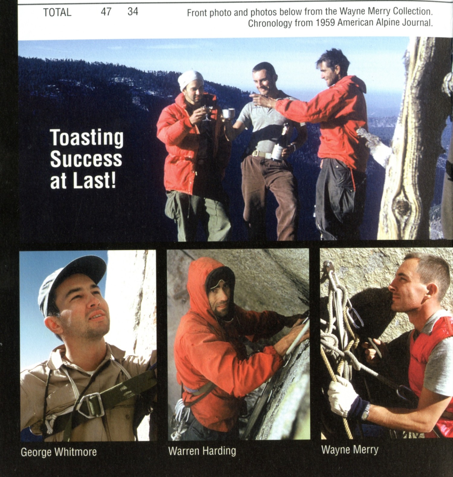
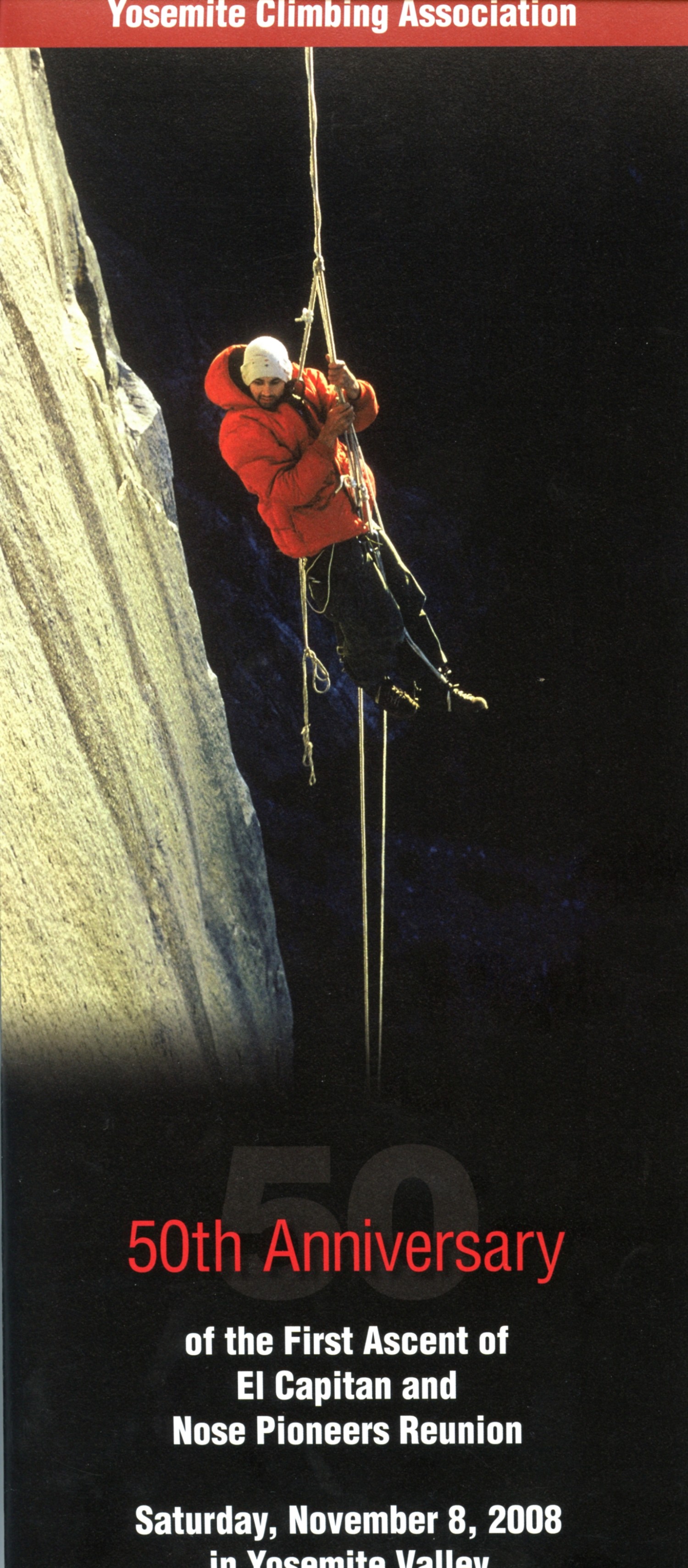
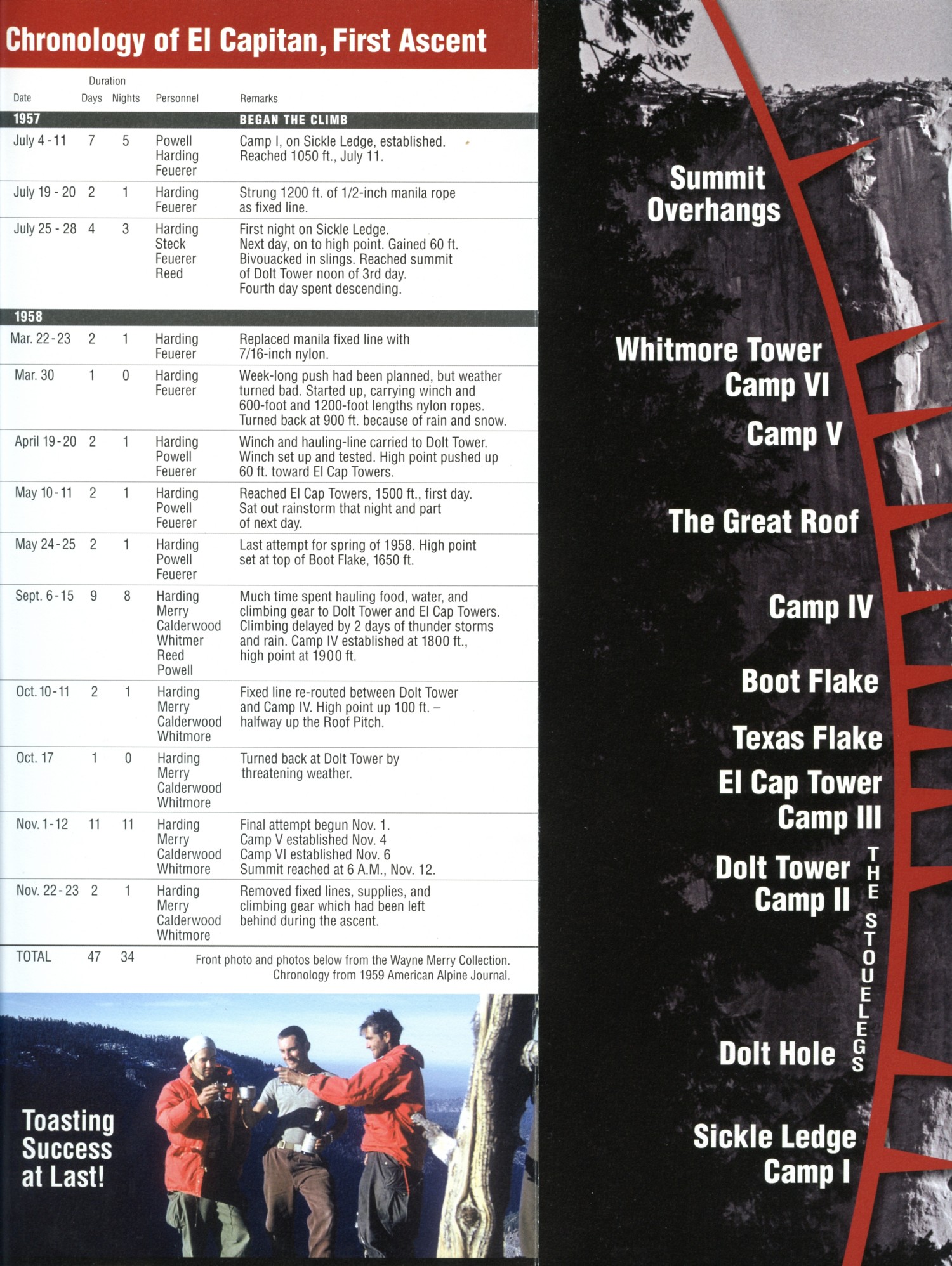
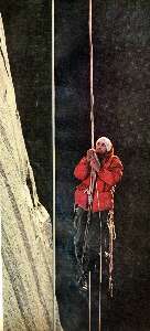
First ascent of El Capitan (Argosy article, 22mb)
(Click the 10 page pdf - 22 MB)
|
|---|
|
"In every walk with Nature one receives
far more than he seeks". - John Muir
"Keep close to Nature's heart...and break clear
away, once in awhile, and climb a mountain or spend a week in the woods. Wash your spirit clean".
- John Muir .
In 2010, I hiked the JMT North to South (link here for the report about this jaunt).
Preliminary: Zero, minus 5 months: The minutia overwhelms.
Sorting slowly through hike plans, and how many daily miles compared to how many ERMs, and finding water along the
way, and resupply options and number of days, and how much food per segment, and how to get additional calories without
adding much weight, and off trail dalliances, and getting to and from the trail, and packing the resupply for MTR, Muir Trail
Ranch, and for Independence, and for Mammoth, and dropping off the pack with Barry to bring it around to the East side,
and it's a bit much.
Zero, minus 1: Finally, the day arrives to ride with Gordon to the YARTS pickup
spot at the Fresno Airport,
and on the way to the Sierra. Yes, finally. After 4 hours on the YARTS, I'm at Yosemite Valley, where Zig and I rendezvous, then
wait some more for the YARTS to Mammoth. It's hot here at 4,000'. Four hours on YARTS from Fresno to Yosemite Valley, four
more hours on YARTS from Yosemite Valley to Mammoth. Pleasant, yet not comfortably spacious.
Meanwhile, Barry is hurrying through Death Valley, attempting to avoid melting his car
tires. He'll meet Zig and me in Mammoth for the evening. One resupply will be left here. The next day, we'll ride with Barry to
Independence, drop another resupply and rest the night.
Finally, Barry will drive all of us to Horseshoe Meadow for the start up Cottonwood Pass
to access the section of PCT, Pacific Crest Trail, and then North to meet up with the JMT, John Muir Trail, near Crabtree Meadows.
Zig and I meet Barry in Mammoth and check in for a civilized evening. We learn that Barry
avoided melted tires by traveling North of Beatty and over to Big Pine in the Owen Valley, a valley de-watered by ever thirsty Los
Angeles and California irrigators. Too many people. Too many farmers growing non-native crops.
From the PBS series Cadillac Dessert: “William Mulholland emigrated from Ireland in
1878, and worked as a ditch digger for the L.A. water system. He quickly taught himself hydraulic engineering, rose
quickly through the ranks, and soon became superintendent. He tried desperately to make the exploding population conserve
water, but growth sabotaged everything he did, and soon the city sucked dry the little Los Angeles River, its only
source of water. Mulholland knew he would have to find new water, and turned to the remote Owens Valley, 230 miles north
of L.A….”
As a common theme in all honest books about our increasingly more catastrophic
environmental, social, judicial, spiritual, and economic problems, is the unreported fact that all conservation efforts
will be outpaced and overrun by population growth. Again, from Cadillac Dessert: “Mexico City, struggling to provide
water for its growing population, is sinking -- in some sections up to 12 inches a year -- due to overdrawn aquifers.
Here, wealthy families get affordable piped water, while poor families must pay high prices for water brought in by
truck. In the developing world, 80 percent of illnesses such as cholera, typhoid and dysentery are related to the lack
of clean water and sanitation.”
As Ed Abbey said "Growth for the sake of growth is
the ideology of the cancer cell."
Without reversal of human population, we, all living things, and the Eaarth are soon doomed.
(Good reading note: Cadillac Desert by Marc Reisner.)
We enjoy a beer and sandwiches in Mammoth, then retire early because none of us
had been sleeping all that well.
Zero day: The morning is a refreshing blend of cool air and clean air as we
wait for Jeremy to cook breakfast sandwiches at the Cinnamon Bear. Yummy. MAGAvirus has reinvented itself in the form of mutations
spawned by vaccine refusers, many of them trumpians, repulsicans. They are earning their Darwin Awards in ever increasing numbers
and at faster rates. Freedumb! It's the antithesis of patriotism when repulsicans don't help in the war against the MAGAvirus. So,
society is hauled backwards by these selfish, duped, non-patriots, and we're eating first breakfast in a parking lot (to properly socially distance).
Then, down the Owens Valley we roll in the luxury of Barry's Subaru, slowly dropping into the
smoke bucket and apparent inversion near Bishop and below. Ick.
There's a second bakery stop at Schat's in Bishop for breakfast sandwiches (for tomorrow
morning) and fritter greaseballs and filled croissants. Exquisite.
Continuing on into the heat (106°F), we arrive at the Independence Inn, where we enjoy a
long discussion with Jim the Innkeeper and later a very fat sub sandwich at Port o Subs. The Mexican food truck is closed, so we don't
get to evaluate it, we'll do this later in the trip. Instead, we eat lovely salads at the Still Life Café and Bistro for dinner. Back to the
Independence Inn for some decent sleep.
Day 1 photos - JMT 2021
Day 1: August 7th. Soup Bowl. To Chicken Spring Lake:
Cottonwood Pass (11,000'). 4.4 miles, ERM of 7.6. Camp @ 11,218'.
Barry is shuttling Zig and me to the Horseshoe Meadows Trailhead amidst a
soup bowl of smoke. Ick. Up and up and up gaining elevation and eventually driving clear of the thick smoke, a resplendent
vista of tasseled trees and fractured rocks appears. The trailhead. Photo time and a fond farewell to Barry. Barry's hip is
troubling him and he is unable to hike with us. He had planned to hike the first leg of the JMT with us, but arthritis gets in
the way. Being the stalwart person he is, Barry helps us get started on the Jaunty Juggernaut. Thanks Barry!
Hoisting bloated packs, Zig and I lurch into the Golden Trout Wilderness, climbing
toward Cottonwood Pass at a bit over 11,000 feet.
It's a climb through a Foxtail Pine forest, the flexi bottle brush limbs adding an exotic
flavor to the trail. Gorgeous, elegant trees.
At the pass, we pause to eat sub sandwiches, a decadent lunch before switching
over to the more pedestrian grub in the Bear canister. Yummy.
In a matter of a hundred feet or more beyond the pass, we turn onto the PCT and
trundle North to Chicken Spring Lake. As we're searching for a camp, a phalanx of scouts arrive and we skirt around to the
West side for a camp with a view and a bit of natural quiet.
The sun is hot and the shade cold, intermittently punctuated by the wind. This
prompts a quick bucket bath.
It's been a busy day because we've seen some 30 to 40 people.
Two of the pleasant encounters are with Mike and Kelsey. Mike tells about being
bluff charged by a Bear in the Charlotte Lake area and has photos to prove it. Wonderful people, good discussions. These
are the only people who we later hear from, despite my sharing my web card (web and email address) with probably a
hundred people on this jaunt. Sigh.
"The world is big and I want to have a good look
at it before it gets dark". - John Muir
Day 2 photos - JMT 2021
Day 2: Rock Rounder. To Rock Creek: 9.64 miles, ERM of 15.5.
Camp @ 9680'.
There's no water between Chicken Spring Lake and Rock Creek, a distance of over
9 miles. So, we're lugging extra water to serve us most of the day. One could say heavy water.
It's a gorgeous morning on the granulated granite bench above Chicken Spring Lake.
The trail wanders through the twisted trimmed Foxtail forest, punctuated with
monarch gnarled lightning-streaked trunks. The forest seems trimmed at the top, perhaps a function of wind?
Lilting along, we're feeling the effects of the altitude and happy that today is a
rolling day. Delightful.
Visions of the Great Western Divide appear on the Northwestern skyline, the land
of the HST, High Sierra Trail, which Barry and I plied a year ago. Just another most excellent adventure in the Sierra.
High Sierra Trip Report (link here).
Our high hike offers excellent vantage points for viewing Whitney Meadow and Siberian Outpost, arranged in
splendid detail below.
On we lilt until the drop into the Rock Creek area, feet getting tired and ready for a
break at the New Army Pass junction. We hike the side trail into Rock Creek Ranger Station, where we chat with Backcountry
Ranger Matt Z. NPS, and view the new scenic toilet at Rock Creek RS, built in the 1940's.
As we're on the side trail to the RS, a long dusty stock string clouds past on the PCT,
heading to the Rock Creek crossing with the Bear boxes, so Zig pulls off the trail early and we find a superb camp above a minor
fork of Rock Creek. No bugs yet this adventure. Yahoo.
From camp on a low ridge above Rock Creek, the creek burbles below, providing a wild
backdrop to a delightful day.
"This I may say is the first time I
have been to church in California".
John Muir, after making the
first recorded ascent of Cathedral Peak in 1869.
Day 3 photos - JMT 2021
Day 3: Wrangling Wallace. Almost to Wallace Creek: Finally on
the JMT. To JMT 11.2. (PCT mile ~ 770.) 9.3 miles, ERM of 18.4. Camp @ 10,700'.
Note: JMT miles are measured from the top of Mt Whitney, North to Happy Isles.
Because of trail rerouting, your mileage numbers may differ.
It's a cool morning at Rock Creek camp and the down coat and hot yet weak
coffee are welcome.
We are on the trail before 7 a.m. and grinding up to Guyót Creek, the last water
until Whitney Creek some 5 miles distant.
Up more to a scenic footnote of Guyót Meadow and Peak. Gorgeous.
Continuing on, we eventually reach Whitney Creek and the bottom part of Crabtree
Meadows. What an astounding vista. In the foreground are Whitney Creek and Crabtree Meadows, backed by the skyline
of what I believe to be the topknot of Mt Whitney and the rampart of Muir.
Some more climbing and we reach the JMT/PCT junction in the heat of the day. More
up, yet less vigorous this time, and we're at the cusp of the drop into Wallace Creek. The trail is pulverized by corporate
welfare mule packing outfitters, socializing the loss (incredible trail damage, increased erosion, compacted and ravaged
meadows, fisheries harmed, wildlife forage stolen, etc.) and privatizing the gain (paying next to nothing to ameliorate the
trail and other assorted damage). Certainly, they are better than the horrid mountain bikers, scourge of many multiple
abuse trails; and stock are historic, bikers are not. I'll add that mountain bikers are certainly willing to share the trail - as
long as they always have the first turn.
We learn from talking with some HST hikers that the welfare outfitters are bound
for Wallace Creek. Oh no, add intrusive not natural noise and congestion to the list of grievances. Clanging lead mule bells
is not natural quiet.
Finding a feeble trickle about a half a mile from Wallace Creek, we locate a previously
used campsite and enjoy.
A habituated deer and youngster visit, yet otherwise it's a surround sound of
natural quiet. Hurrah.
Camp duties and journal notes dip into sunset and beyond. It's shaping up to be
a cool, bordering on cold, evening at JMT mile 11.2.
Click here for -- A note about tin-can tourists
"The power
of imagination makes us infinite". - John Muir
Day 4 photos - JMT 2021

|
|---|
Movie 2 - Bighorn Plateau, Day 4, 24mb
(Click the image to see the video)
|
|---|
|
Day 4: Moonscape. To the South flank of Forester Pass:
7 miles, ERM of 12.5. Camp @ 11,830'. JMT mile 18.2. PCT mile ~ 776.6.
Mule bells clank below as Zig and I pack up for the day. An excellent reason
to camp far enough from the Bear boxes. How far is far enough? It's generally an acoustic question.
The short drop to the Wallace Creek crossing is followed by a stepped climb to
Wright Creek, and another to the Bighorn Plateau and circular tarn. We're walking on granite occasionally tinted red
by potassium feldspar, one of the constituents of granite. Interesting. Glorious views of the low angle hulk of Mt Whitney,
and, the other direction, a terrific view of the Great Western Divide. I chat with Raymond and later Bailey about the joy
of traversing the JMT.
A micro burst of mini twister sends both hats sailing. Zig's cartwheels toward the
tarn and mine sails and settles amidst open ground the same color as the hat. We're able to retrieve both.
The Bighorn Plateau is one of the special places on the JMT and we reluctantly
press on to Tyndall Creek, surrounded by friendly Foxtail Pine. Several of the Tyndall forks are dry. Alarming.
Zig wants to get partway up to Forester Pass (13,120'), highpoint of the PCT. It's
not the highpoint of the JMT, which ends on Mt Whitney (14,505'). Forester is atop the Kings-Kern Divide. We've been
walking in the Kern Drainage while the Kings is over Forester. So, we creep up the trail, out of the friendly Foxtail Pine
forest and into a moonscape of rocks. Water and campsites are rare and offer next to no protection from the marauding
winds. After a good deal of searching, we locate barely passable tent spots amidst the tough ground cover and small
boulders, boulders too small to offer wind protection and too small to sleep on. Water is a tiny basin scooped out next
to the trail, where a feeble spring drips.
Apex tent guys and all anchors are employed, along with numerous rocks.
The wind dies to a whisper along with the sunlight.
"Thousands of tired, nerve-shaken,
over-civilized people are beginning to find out going to the mountains is going home;
that wilderness is a necessity..". - John Muir
Day 5 photos - JMT 2021
Day 5: Cirque Coyotes; Forester Pass. To Golden Bear Lake outlet, Bubbs Creek:
7.5 miles, ERM of 17. JMT mile 25.7, PCT mile 784. Camp @ 10,530'.
Coyotes call to their brother and sister Song Dogs as early sun hits their bench.
"How is everyone doing today?" they ask.
Zig and I are up before dawn and on the hunt for Forester Pass. It's quiet and
calm and relatively easy hiking to the upper lakes, where I wonder... Where's the trail? It must surmount the ridge
poking up in front of us? Zig points out the trail carved into native granite. Yoweee. It apparently zigzags up through a
talus slope, then switchbacks up the granite face, cut into and bridged across the rock. We pass the Downs plaque. He
was a nineteen year old youngster who died building this trail in 1930.
It's a well-graded trail, making the elevation less noticeable. Amazingly, it is
blasted and carved through a narrow notch in the dip of the ridge leading to Junction Peak.
At Forester Pass! A gaggle of cute girl scouts share the pass with a young Pika
and wilted Sky Pilots. There's a new regime of peaks and valleys ahead, wow.
Now for the 2600' decline to camp near Bubbs Creek. Ventriloquist Marmots
chirp their irritation or warning as I gather cold clear water from a heathery grass-lined stream exiting what may be a rock
glacier holding back a pond.
All this downhill reminds us of hiking the Grand Canyon. Of course, the initial drop to
River level is more than 2600'.
All WV reports about hiking the Grand Canyon (link here).
We're now rounding Center Peak and the Kearsarge Pinnacles.
A footbreak near a trickle of water prompts us to get out the Good Book
(Elizabeth Wenk, Hiking the JMT) and read prophecy about today's journey. The best scripture ever. All so-called
scripture is blasphemy but that from this Good Book.
We've dropped into the Whitebark Pine and now into the Lodgepole Pine
forest and we camp just prior to what we believe will be a busy camp near Bear boxes and a ford of Bubbs Creek.
Time to catch up with laundry and proper bathing and such.
Thunder rumbles from the direction of Forester, and I hope everyone is down safe.
"The grand show is eternal. It is always
sunrise somewhere; the dew is never dried all at once; a shower is forever falling; vapor is ever rising. Eternal
sunrise, eternal dawn and gloaming, on sea and continents and islands, each in its turn, as the round earth
rolls". - John Muir
Day 6 photos - JMT 2021

|
|---|
Movie 3 - Bubbs Creek, Day6, 7mb
(Click the image to see the video)
|
|---|
|
Day 6: Bull or Bullfrog. To Kearsarge Lake:
7 miles, ERM of 12. To the base of Kearsarge Pass, at Kearsarge Lake. Camp @ 10,950'.
Early light glints off the striated polished granite that forms the foundation for my TarpTent. Fabulous.
It's a glorious morning walking downhill on the JMT, enjoying the cascades of Bubbs Creek, the
polished exposed granite bedrock, and the morning coolness.
Before long we're at the Bubbs/JMT junction and turn sharply uphill out of Vidette Meadows
and climb to the Bullfrog Lake junction with the JMT. No longer on the JMT, we're hiking around Bullfrog Lake as we continue into this
cirque to Kearsarge Lakes.
We are on the way over Kearsarge Pass to Independence to resupply. But first, a night at
Kearsarge Lakes. Then the pass and to Onion Valley trailhead, where Jim of the Independence Inn is to shuttle us to town.
Despite the gathering dark gray clouds forming to the South, we explore and explore some
more for a decent campsite with adequate drainage and good wind protection. We find such, and it takes some effort to fit in the tents.
I unpack the backpack and place it under the sleeping pad to level out the slope. A border of erratic boulders and stunted
Whitebark Pine is a terrific find.
Instead of hurrying ahead with dinner preparation, Zig and I walk over to the other
Kearsarge Lakes in this series.
A light rain and hail storm cuts short dinner preparations, so I'm writing these journal
notes, in the tent.
Along the walk today, we enjoy an excellent discussion with Ryan and Lauren and later
with Adrian from the British Empire. Adrian is a PhD candidate in history who reports that Americans are broadly bigoted, whereas
British morons talk mostly about immigration, the fictional boogeyman. It seems like a trump play book, grab power by blaming
the other so the disenfranchised don't realize it's the trumps of the world who are the problem, not the other. Corporations are
the problem, greed and power brokers are the problem. Tax cuts for the wealthy and corporations breed greed, never the fictional
"trickle down." Rather than protect the people, government, especially repulsican government, socializes the loss and privatizes the
gain, a very nasty and selfish cycle. The goal of repulsicans is a government of authoritarian capitalists, increasing the wealth disparity
and shunting workers and citizens to third class standing, that is, no standing at all. Unless you are uber-wealthy, voting repulsican is
voting against your own best interests and those of the Eaarth.
Near Bullfrog Lake, we chat with a group of university students studying Mountain
Yellow-legged Frogs, each carrying a backpack with a net protruding out the top like a space antenna. The report is that the frogs
are doing well in some ponds, poorly in others. Removing non-native trout from selected high-mountain lakes at Sequoia &
Kings Canyon National Parks gives native frogs a chance to survive, we are told.
I pop out of the TarpTent and cook dinner while thunder echoes ominously. There're
thoughts about squatting on the closed cell pad with heels pressed firmly together to form the shortest electrical circuit, rather
than having the storm's electrical energy pass through other important, and precious, parts. The heart makes a poor circuit breaker
for massive electrical discharges, i.e., lightning. Shocking information! The storm is more thunder than rain production. A renewed
roving wind reinforces our careful tent positioning and ushers out the storm as dusk drops.
"One touch of nature makes the
whole world kin". - John Muir
Day 7 photos - JMT 2021
Day 7: More Kearsarge. To Onion Valley trailhead and Independence Inn:
Kearsarge Pass, 11,760'. 7.6 miles, ERM of 16.6. Camp @ 4,000' in the Inn.
The Pika pops out near Zig's hiking pole and displays his innate cuteness. Of course, I try for a photo.
We're able to stay in the shade to the pass, where we enjoy great views and a friendly
Alpine Chipmunk. The gorgeous photogenic Kearsarge Lakes and Pinnacles are left behind at the pass.
Zig contacts Jim G. at the Independence Inn to arrange a shuttle from the trailhead to the
Inn before starting the sweeping switchbacks down 2800' into Onion Valley. It's a Vitamin I descent, the "I" being Ibuprofen.
Administered prophylactically, the knees are eased. Using poles helps too, partly by taking part of the weight and also by causing
one to lean forward. Leaning forward can change body position so that the knee stays bent rather than straight, straight drives the
force through the knee while bent employs the quadriceps, acting like a shock absorber. Coupled with walking more flat-footed
(rather than striking the heel), your knees will thank you. I chat awhile with Mike about major downhill cruises.
Down past Big Pothole, Heart, and Gilbert Lakes. Down from Foxtail Pine to Lodgepole
Pine to Mountain Mahogany, to Sagebrush, slipping through ecozones and into the heat. We meet Walker and Anton on their way up,
out of the heat. They're smiling and so are we, we're headed for the taco truck.
Our next JMT section is pass after pass: Glen, Pinchót, Mather, and Muir. Yowee. So, some
rest time in Independence seems warranted.
Yet for now, Zig and I enjoy some downtime and the hospitality of Jim G., Independence
Inn Innkeeper. Although it's 110°F in Independence, we enjoy the coolness of the Inn. Thanks Jim.
We partake of the taco truck and eat lots of snacks during this Independence recovery
time. Delightful.
"Going to the mountains is
going home". - John Muir
Day 8 photos - JMT 2021
Day 8: Kearsarge Redux, Orange Blood Sun. To the foot of Glen Pass:
9.2 miles, ERM of 19.8. JMT mile 32.6. PCT mile 791. Camp @ 11,550'.
The orange blood sun breaks the horizon, sporting a line of yellow clouds across
the disc and appearing like Saturn in the smoky smog soup bowl that fills the Owen Valley. Enthralling and also Ick.
Jim has dropped off Zig and me early at the Onion Valley Trailhead, and we're
inching back up to Kearsarge Pass with bulbous backpacks filled with food, etc. The 2800' rise goes well, and we fill water
at the middle lake before reaching the pass. An excellent location for third breakfast. The trail is crowded by a hoard of
hikers, most apparently returning for church services after a weekend trip to busy lakes. We note that we are heading to
church, the cathedral of the pines. Along the trail we encounter Adrian of the UK on his way back to Berkley for historical
purposes. He tells about being nearly swept away when a high angle talus slope he was crossing started to move like a rock
avalanche. His climbing trip was exciting but not particularly fruitful because the rock was of poor quality. He is engaging,
partly because of his characteristic British wit and sarcasm, and partly because he's very quick mentally.
We take the high scenic trail through the Kearsarge Lakes area, pausing for lunch
before rejoining the JMT and beginning the climb to Glen Pass. We're able to find decent campsites at the base of the pass,
alongside Lake 11,540 at JMT mile 32.6. It's been a long day and we're happy to be back among the Sierra
crags.
"Not blind opposition to progress,but opposition
to blind progress..". - John Muir
Day 9 photos - JMT 2021
Day 9: Woods Downer. To Woods Creek Crossing:
Glen Pass, 11,950'. 9.4 miles, ERM of 18. JMT mile 42.0. PCT mile 799.8. Camp @ 8550'.
My feet languish frigidly in the steam tumbling down from a high mountain lake.
A super deluxe footbreak and second lunch indeed. Ahh. It's been a huge downhill, elevation loss day, with a highpoint of
11,950' and a low point of 8550'.
Zig and I start early with the final climb to Glen Pass, followed by a switchbacking
drop into the Rae Lakes Basin.
In 1906 the lakes were named for Rachel "Rae" Colby, wife of conservationist William E. Colby.
Smoke and haze obscures the ranging views as we walk the narrow land bridge between
two of the lakes and trudge over glacier-scraped and polished bedrock past Arrowhead and Dollar and other lakes. The Rae Lakes
Ranger Station is new, yet the scenic toilet may well be the one that I photographed eleven years ago, a metal throne perched
on the sidehill above the Station. Rustic. Sadly, other photo attempts are plagued by smoke, obscuring the views. There just
aren't many decent photos today.
Fin Dome provides decent reflections in the Rae Lakes.
Down more. A few patters of rain bring welcome clouds and higher humidity.
Still, we're hiking downhill.
At the swinging bridge over Woods Creek, called "The Golden Gate of the Sierra," we
find a campsite under a Jeffery Pine and catch up with proper bathing before another storm blows in. We're also among Western
Juniper which the Good Book says is a conifer despite it's shaggy bark and scaly leaves.
Wondering about the chances of getting beaned by one of the humongous Jeffery Pine
cones, we scramble completing cleanup as it appears that the storm is cranking up. It's mostly wind.
"One should go to the woods for safety, if
for nothing else". - John Muir
Day 10 photos - JMT 2021

|
|---|
Movie 4 - Gooseberry Grouse, Day 10, 7mb
(Click the image to see the video)
|
|---|
|
Day 10: Stairmaster Pinchót. To Lake Marjorie:
9.0 miles, ERM of 18.2. JMT mile 41.9. PCT mile 808.6. Camp @ 11,150'.
Pinchót Pass, 12,122', is named for Gifford Pinchót (1865 - 1946), first director
of the Forest Service. He was appointed by Theodore Roosevelt.
Stairmaster or stairway to slippery slide? The trail starts out as the direct route,
mostly up. Before long there's a long water slide and a moraine bordering it.
I hear what reveals itself to be a Blue Grouse mewing and plucking what looks like
gooseberries. Gooseberry Grouse.
Surprisingly bold, she gleans precious fruit while I snap photos. Thanks, Ms. Grouse.
A terrific aroma wafts down the trail from unseen pines. Ahh. Then the familiar
perfume of Coyote Mint. It's a grind, punctuated by exquisite scenery and intricate meadows. There's more soil in places,
perhaps because there's metamorphic rocks that have joined the igneous? Three snack breaks brings us to the last pond
where there's sponge cake peat bog floating mats of grass around this last pond.
Flapping shirt and cold ears result from the wind, which seems to be cranking up.
An ear band and hat anchor are required. Finally to Pinchót Pass for the final snack before descending to Lake Marjorie in
search of a protected camp, the wind still gusting hard enough to sail one's hat far into the lake.
It takes hours to locate a decent campsite for me, Zig having found one quickly. It's
dark by the time the gale lessens enough to pitch the tent. A very tiring afternoon.
"Everybody needs beauty...places to play
in and pray in where nature may heal and cheer and give strength to the body and soul alike".
- John Muir
Day 11 photos - JMT 2021
Day 11: Medial Moraine Mosey. To Palisade Lake:
Over Mather Pass, 12,094'. 10.5 miles, ERM of 19.3. JMT mile 61.9. PCT mile 819.4. Camp @ 10,860'.
Mather Pass, named for Stephen Mather, first head of the National Park Service, 12,094'.
It's a cold morning and we don't see the sun until we hike down to the South
Fork Kings, where there's some sun beginning to peek through the Lodgepole Pine forest. Along the way, I visit the
tent that is the Bench Lake Ranger Station. I find the station but cannot find the accompanying scenic toilet. Drat.
Second breakfast is near the now mild South Fork Kings River.
Now it's up, basically all the way to Mather Pass. Initially it's a young forest walk,
and as the trees thin, then disappear, it's a glacial cruise where the grade is manageable. We're surrounded by a jagged
ring of mountains, akin to something from the Lord of The Rings. First and second snacks are enjoyed at water stops along
the way and lunch is on a medial moraine.
The Good Book notes that the West side of the valley is granite while the East sports
many metamorphic peaks. Interesting. A revelation.
As we near the base of Mather Pass, we hike onto a medial moraine that separates
what appear to be two cirque basins.
The last segment to the pass is well graded.
Looking over the North side of the pass, we see Palisade Lake and Creek, which
eventually helps form the Middle Fork Kings River.
It's a drag down to camp near where Palisade Creek crosses the trail on its journey
to Palisade Lake.
A very cool evening ensues. I'm happy that we've seen no people since leaving
Mather Pass, a rarity along the busy JMT.
"One day's exposure to mountains is better
than a cartload of books". - John Muir
Day 12 photos - JMT 2021

|
|---|
Movie 5 - Bubbs Cascade, Day 12, 22mb
(Click the image to see the video)
|
|---|
|
Day 12: Palisade Plume Plunge. To Big Pete Meadow:
13.3 miles, ERM of 22.5. JMT mile 75.2. PCT mile 832.6. Camp @ 9250'. (Lowpoint of 8030 feet today.)
Smoke fills the valley, obscuring the grandé vista afforded by the Palisade drainage. Ugh.
The first part of today is down and down Palisade Creek. Along the lake, the trail is
etched into solid rock. Wow.
Through the outflow notch of this suspended cirque, and... The Golden Staircase!
The Golden Staircase was completed in 1938, the last segment of the JMT. It harbors approximately 50 switchbacks.
Through Lodgepole and Jeffery Pine, it's a glorious downhill plunge, except for the smoke.
It's like plunging into a plume. Ick.
First lunch is at a cruising cascade of chilly Palisade Creek water sluicing over glacier-burnished
granite. The Devils Crags are there, somewhere. Spectacular. Steve, a thermal engineer, comes along and joins us for lunch. He's
climbing, we are descending. We're all admiring and enjoying.
Meeting the Middle Fork Kings River, Zig and I start regaining some of the lost elevation.
We've dropped to 8030' and are beginning the quest to surmount Muir Pass (11,969'). To Grouse Meadow, to Little Pete Meadow,
to Big Pete Meadow, up. To the Bishop Pass junction and the LeConté Ranger Station. It's a new station made from peeled and fitted
logs accompanied by a new scenic toilet. Delightful. The Ranger is out on patrol, so photos suffice. I sit in the shade near the new
RS admiring the scenic toilet and, well, the scene that is this edge of a small meadow. A terrific place to spend a Summer, it reminds
me of our times in the Frank Church River of No Return Wilderness several years ago....
Volunteering in the Frank Church River of No Return Wilderness (link here).
Tiring, Zig and I search for a campsite. The area is clogged with those going to or coming
from Bishop Pass, and those waiting to be resupplied by pack string (horses and mules) via Bishop Pass.
So, on and up we struggle, finally finding a camp and water together. It's an excellent camp
because we're able to find previously used sandy tent sites uphill from the fire-smudged central sites. Time for a full bucket bath and
a bit of laundry, dinner, then catching up on these notes.
The Middle Fork Kings River, raucous and rumbling from its gorge, and the nearby burbling
creek provide background natural quiet for a not long enough rest.
"Who wouldn't be a mountaineer! Up here all
the world's prizes seem nothing". - John Muir
Day 13 photos - JMT 2021

|
|---|
Movie 6 - Midle Fk Kings - Le Conte Canyon, Day 12, 12mb
(Click the image to see the video)
|
|---|
|
Day 13: Rock Monstering Muir. To Wanda Lake:
Muir Pass (11,969'). JMT 83.4. 8.2 miles, ERM of 15.5. Camp @ 11,400'.
It's a quiet morning as we hike uphill looking for the Rock Monster. When
we finally spot it, it's fairly obvious between the trail and creek. The Monster tries to eat me for its second
breakfast, but I escape.
This entire stretch has been climbing toward Muir Pass, since leaving
Palisade Creek many feet and miles below.
Second breakfast (for me, not the Rock Monster) is streamside gazing
at the Black Giant perched on the Black Divide. Stark metal-flaked rocks, hints of mica add shimmer to the
igneous cobbles. The water is gorgeous, crisp, clear, nearly transparent in its purity. It's a good place for a
footnote to The Black Giant, on the Black Divide towering above us.
The trail climbs, briefly levels, climbs, etc. Eventually to Helen Lake,
where the final climb begins to Muir Pass (11,969') and Hut. On the long haul up, I pause to chat with
Suzanne and Karen, hiking the JMT.
We enjoy another lunch in the Muir Hut. It's restful to get out of the
glare from the white granite, which at times reflects light like a snow field. On top of Muir Pass, roughly halfway
along the length of the fabled John Muir trail that goes from Happy Isles in Yosemite to Mount Whitney in Sequoia
National Park, is the Muir Hut, or Muir Memorial Shelter. The stone building was constructed by the Sierra Club in
1930 both to honor its founder, John Muir, and to offer an emergency shelter for hikers caught out in a storm. We're
avoiding a storm of electrons knocking about in the glaring granite and recharging our photovoltaic arrays
(solar panels) outside the hut.
On the descent from Muir Pass we're going very slowly and quit at the
Wanda Lake outlet. We've transitioned into the San Joaquin River drainage.
Messages arriving on Zig's Zoleo from Bob G., who is serving as "base
commander," warn of increasing smoke ahead. "Oh, what fun," we comment. Currently, the smoke layer is
creeping up the valley, soon engulfing us.
An orange blood moon glows faintly through the night and smoke. Cold
hearted orb that rules the night, extracting oxygen, what a plight.
"Between every two pines is a doorway to a
new world". - John Muir
Day 14 photos - JMT 2021

|
|---|
Movie 7 - Dipper in Evolution Creek, Day 14, 7mb
(Click the image to see the video)
|
|---|
|
Day 14: Evolving through Evolution. To South Fork San Joaquin:
13.9 miles, ERM of 21. Camp @ 8400'
It's a cold, smoky start to Day 14 and I'm reluctant to take off layers until
the sun meets me at Evolution Lake.
Reflections abound in Evolution Lake as the haze briefly lifts. Gorgeous.
After cruising the lakes, a deep descent follows. Another staircase of sorts.
Down toward Colby and McClure Meadows. To the McClure Ranger Station and scenic toilet. The Backcountry Ranger
reports that there's another fire, this time South of us near Lake Isabella, the French Fire. It seems that we are surrounded.
Surrounded by fire, a troubling and intrusive thought. Continuing on into Evolution Meadow, it's a lovely low angle forest walk.
The ford of Evolution Creek is but ankle deep, a huge contrast to most JMT
crossings where thigh-high or higher is the norm during most years, but not this year. (This will be our only ford of the trip!)
I wondered where the dreaded Bear Creek crossing might be, then realize I walked across it on rocks, a mere trickle of its
typical self. A harbinger of water migrants fleeing many desiccated places on Eaarth? But to where?
Dropping down on tight switchbacks alongside Evolution Creek, I see a Dipper
(Water Ouzel) standing in a coursing cascade and prying bugs off the bottom as water crests over it. Creative.
Crossing the South Fork San Joaquin on a bridge, we continue along this gorgeous
stream until we find a good camp near the river. It's very possibly the same site used on Day 14 of my first JMT adventure.
Coincidence? Day 14, 11 years ago, Day 14 today. I know this because I had marked the 2010 camps on my Tom Harrison
mapset. Some would say karma, others would realize that the probabilities are supportive of overlapping camps.
The air quality is somewhat okay, better than last night. Zig and I remain cautious
about faint smoke or clear days ahead.
The burble of the San Joaquin is pleasant natural quiet to a long hike day.
"When we tug at a single thing
in nature, we find it attached to the rest of the world". - John Muir
Day 15 photos - JMT 2021

|
|---|
Movie 8 - Muir Rock alongside S Fk San Joaquin, Day 15, 20mb
(Click the image to see the video)
|
|---|
|
Day 15: Irrational Exuberance! To MTR:
5.6 miles, ERM of 8. Camp @ 8070'. Visit Muir Trail Rock and Muir Cabin. Resupply. Laundry.
Muir Trail Rock hides alongside the morning gold reflected on the South
Fork San Joaquin. Delightful. The San Joaquin, bound for fields of non-native plants, and worst of all, invasive
livestock, harbingers of the end of nature and the Eaarth. One wonders how come less water intensive plants
aren't grown down below in America's garden? What portion of the Eaarth's land mass is misused to support
livestock, something like 45%? Too much, and too great an impact. Time to get off animal proteins, starting with
the greatest offender, cattle. We might also talk about the welfare ranching industry on our public lands, abusing
the land, fouling streams, killing native animals and extirpating native plants.
"Agricultural land can also be broken down by whether it is used for
livestock vs. crop production. Livestock is the biggest of all land users in the world according to some sources,
and far outweighs the use of land for crop production. According to some estimates, 70 to 80% of agricultural
land is used for livestock, and only about 20 to 30% for crops. Beef/cattle in particular might be the largest land
user at around 60% of all agricultural land."
How much land is used for livestock? (link here).
This is how come I have long ago stopped eating beef anything. It's a
scourge on our Eaarth and results in particularly horrible outcomes on our public lands. Fowling streams, rivers,
lakes, eradicating predators necessary for a balanced ecosystem, stealing forage from native animals, compacting
soils and becoming a single-use subsidized depletion of our lands, there is nothing good about grazing on our public
lands.
Not convinced? See ---->
Western Watersheds Project (link here).
Craving a hamburger? Get something else. Please, for the Eaarth.
After crossing the Piute Creek Bridge, we start the hunt for Muir Cabin, finding
it pretty much as depicted on the USGS topographical map. This cabin was not used by Muir. No. Instead it was built by
FS folks in honor of Muir, long after his death.
We're back in the land of sweet smelling Western Juniper conifers and the
vanilla goodness of Jeffery Pine. Scrumptious.
On to MTR, Muir Trail Ranch, where weeks earlier we had mailed resupply
buckets stuffed with necessities for the next section. The buckets are brought into the MTR via boat, mule, unimog.
We're breaking up the long mileage and elevation days planned in a time
of irrational exuberance into shorted mileage days, and skipping Mono Hot Springs and VVR, Vermillion Valley Resort,
to allow time to do this. We dust into the Muir Trail Ranch (MTR) to a gathering throng of hikers seeking buckets of
food. Good thing we are early. We chat with Henry while Estelle finds our buckets.
Scrounging enough additional food to allow this, with kind help from Estelle of MTR, we repack
before wading across the San
Joaquin to visit Blayney Hot Springs. I had to point out that I was essentially homeless and very old to get any
additional food from the guardians of MTR, who told me that they saved all the extra food from buckets for the homeless.
We find a nice hot pot in the Blayney Meadow hot springs area and soak
briefly. I'm concerned that squirrels will again assault our camp, so I return to camp. Earlier, a squirrel chewed a
hole in the waist belt of Zig's pack, going after a bit of hard candy stored there.
We heat water and wash all our clothes, using the resupply buckets like
washing machines. Delightful.
Filling sunscreen and other bottles, repackaging scrounged meals,
etc. takes us into early evening.
Braydon joins us for dinner conversation.
It's been a long and productive day.
"Writing is like the life of a glacier;
one eternal grind". - John Muir
Day 16 photos - JMT 2021
Day 16: Contrast Effects. To Marie Lake:
Over Selden Pass (10,913'). 8.9 miles, ERM of 16. Camp @ 10,650'.
My lungs protest as they haul in the smoke-laden air. I can't see the South Fork
San Joaquin in the valley below. Ick.
It's a heavy lift from MTR to Senger Creek, Sallie Keyes Lake, and finally Selden
Pass (10,913') because the Bear canisters are loaded down with food for the next section. Zig weighs his pack at MTR
and concludes that the scale is off by 8-10 pounds. It's a huge contrast to the light flyer packs with which we floated
into the MTR area. Contrast effects. After the initial grunt on the connector trail out of MTR, the trail is generally well
engineered. This helps, yet not enough.
The smoke is fading some as Chainsaw (Will, a PCT hiker) and I talk about the
impending doom for the Eaarth and its inhabitants as psychopaths like trump and corporations most everywhere pursue
their self-serving agendas, mostly antisocial greed. These grifters con freedumb repulsicans into voting against their
own interests, fearing the "other" when in fact the would be authoritarian dictators (autocrats, plutocrats) are the
ones ruining their and our lives. Further, as Bill McKibben predicted decades ago in his book, The End of Nature,
mankind (unkind?) will do mostly the opposite of what is needed to prevent a series of climate related catastrophes.
A sentient being clearly sees that this is currently happening, huge wild fires, 'once in 100 year' storms every year,
mass extinction of animals, birds, insects, plants, all sorts of life. Sad. I much preferred the old Earth, before it was
modified by man to such an extent as to be unrecognizable, hence the revised spelling "Eaarth." No, it's not a future
catastrophe, but a catastrophe in progress leading up to a point, quite soon, where disaster costs will exceed the
GDP (Gross Domestic Product) and suddenly, suddenly even members of the repulsican party and corporate elitists
will see what is needed. Maybe, probably not.
The hike today is grand. Sallie Keyes Lake is a sapphire blue. Gorgeous. A
nearby snow survey cabin is locked up tight and I cannot find an associated scenic toilet. Drat.
Up and over Selden Pass we toil, to see the wonders of Marie Lake with its
azure water, peninsulas, and island. Lovely.
A wind protected camp is not easy to locate.
As I write these notes, smoke is steadily obscuring the Sierra. Oh no. The
streams are often dry. The snowpack is miniscule compared to historical averages. You know, global warming. A
haunting observation to end an otherwise (other than the smoke) delightful day.
"I only went out for a walk, and finally
concluded to stay out till sundown, for going out, I found, was really going in".
- John Muir
Day 17 photos - JMT 2021
Day 17: More like it. To Mono Creek Trail junction:
12.7 miles, ERM of 23. Up 1150', down 3830'. Camp @ 7940'.
A crisp pre-dawn morning and Orion is blazing prominently, lying down
on the SE horizon. This is more like it.
Clear air offers superb reflection photos near the Rose Lake junction.
This is more like it.
Yes, the air is clear, allowing the heat to leave and frilly ice to form in a
slow stream segment. This is more like it.
It's a downhill glide to the Bear Creek Trail junction, past flowers in meadows.
Bear Creek is but a rock hop, not the dangerous ford of yoré.
It's like getting new glasses everything is so clear. This is more like it.
Up and up to the Bear Ridge Trail junction, much more of a grunt than
expected, then down and down to the
Mono Creek Trail junction. A dizzying array of sweeping switchbacks, perhaps hundreds of them, drop down the
hiker to Mono Creek at about 7900'.
And, to inhale and be greeted with the aroma of Jeffery, Whitebark, and
other Pine, the satisfaction of faintly cedar Western Juniper. Ahh. This is more like it.
Not the foul cesspool of what trump's breath must be like. No. What would
you expect the breath of an authoritarian charlatan grifter psychopath to smell like? Horrid.
It's a long down elevation day and we're much lower than when we started
just after starset this morning.
The tumbling natural quiet of Mono Creek provides white noise, covering
the unnatural noise of PCT/JMT hikers talking too much and too late into the good night.
"We all travel the Milky Way together,
trees and men". - John Muir
Day 18 photos - JMT 2021

|
|---|
Movie 9 - Blue Grouse, Day 18, 8mb
(Click the image to see the video)
|
|---|
|
Day 18: Grouseville. To Squaw Lake:
Silver Pass (10,895'). 8.1 miles, ERM of 16. Camp @ 10,300'.
The day starts cool and low (in elevation) along the raucous writhing waters of Mono Creek.
As we start the up and up, I notice young Bear tracks on the trail. He's making
his way toward the VVR, Vermilion Valley Resort, or perhaps just using the trail as a handy access to berryville?
After passing through well-named Pocket Meadow, Heather Mermaid and Emily
Brazen Backpacker stroll up the trail. We've been exchanging greetings for the past several days and we're all planning to
spend time in Mammoth. Perhaps we'll meet again?
Photos together
Heather Mermaid
Emily Brazen Backpacker
The trail continues up through increasingly alpine terrain. During a snack, or second
breakfast, stop, a Clark's Nutcracker is our only visitor, scolding us and talking Jay talk.
It's a slog working our way up over 3,000' to Silver Pass. It's beautiful along the way,
partly because the air quality is again almost average (good). The Sierra air quality is usually excellent, but not recently because
of the surrounding forest fires. Ugh.
Eventually, Silver Pass is attained and it's time to soak in the fabulous vistas and eat a late lunch.
Then, we switchback down several hundred feet to Squaw Lake, where campfire debris
is mixed into the granulated granite. A pox on fire starters everywhere. It's difficult to camp without getting coated with soot. Icky.
During a trip to the lake outlet for water, I hear chortling clucking. It's Ms Grouse and
two youngsters. Grouseville. They tolerate me taking photos and shooting video. Satisfying.
It's feeling like it's going to be a cold night, so I gather all the equipment that could be
damaged by freezing, such as the water filter, and bring them in the tent or the vestibule.
The wind slithers through the trimmed and stunted pines which form part of the
windbreak, yet doesn't affect the TarpTent or my sleep. Goodnight from Squaw Lake on Day 18 of the Jaunty Septuagenarian
Juggernaut.
"The sun shines not on us but in us".
- John Muir
Day 19 photos - JMT 2021

|
|---|
Movie 10 - Skyline & Tully Hole-Fish Cr, Day 19, 23mb
(Click the image to see the video)
|
|---|
|
Day 19: Phantom Hill. To Duck Lake Outlet:
JMT mile 140.1. 9.7 miles, ERM of 18. Camp @ 10,190'.
It's a cool morning accompanied by fantastic views to Banner Peak near
Thousand Island Lake. Yowee. Ridges and peaks everywhere, appearing as in a clump rather than an
organized range. Complicated.
Down, with skims of ice, to Fish Creek crossing on a steel bridge.
We're now hiking in the Fish Creek watershed of the San Joaquin River. I see a gorgeous reflection and meadow
photo on the way down. Ruben, Commando, meeting, also on the way down. He's hiking the PCT from Washington.
Then up into hot sun sagebrush hillside alongside tranquil Fish Creek to
Tully Hole. Switchbacks lead to a traverse into Lake Virginia. Second breakfast is enjoyed looking at the ridge
between us and Silver Divide.
The air is mostly clear, although I can see gray grunge creeping up the
lower valley.
Next is gorgeous Lake Virginia, surrounded by complex geology featuring
metamorphic and igneous intrusions juxtaposed. Some black, others red, and the white of area granite. What
happened here?
Over the next bump to Purple Lake we hike. A rock glacier borders this
section of trail for awhile.
Now we encounter the phantom hill issue. What looks like a contour
around a bluff is actually a sustained climb above steep slopes. Finally, we careen dramatic switchbacks down
to the Duck Lake Outlet and camp.
"The clearest way into the Universe is
through a forest wilderness". - John Muir
Day 20 photos - JMT 2021 + Mono Lk
Day 20: Reds Rumpus Rescue. To Reds Meadow Resort and Mammoth:
11.3 miles, ERM of 18.5. Camp @ 7750'. The contour that is.
It's an N-95 morning as we start out for the next water at Deer Creek, five miles hence.
Zig has on his N-95 mask, and for good reason. Smoke! A Ronald Reagan of smoke, oh so harmful and despicable. A Ronnie
Reagan is a huge pile of unpleasantness, destroying future liberties and economic viability via lies, propaganda, and horrid
policy such as gutting regulations intended to protect people from psychopathic corporations.
Here's the contour that we were expecting yesterday. A pleasant glide through the current monoculture of
Lodgepole Pine around a large bluff, mostly level, on the contour. It's a rumpus delight, moving along smoothly.
I hike and talk awhile with Kevin as the contour continues. Kevin, an electrical engineer who worked designed
semiconductors, is attempting to hike a section of the PCT, if the fire gremlins allow it.
Later, I meet Jenny, who moved to DC to fight the good fight with the National Park
Conservation Association. She once worked at some of the small Monuments on the Colorado Plateau, Wupati, Sunset Crater, etc.
As Zig and I are lounging in the shade alongside a crisp cold water streamlet just North
of Fish Creek (which appears to have been defiled by an algae bloom, another sign of global warming), we see a vision; Barbara
bringing delectables. Fresh fruit, hard boiled eggs, other good stuff. Rumpus Rescue!
We all hike past the Red Cones, cinder cones, and through the 1992 Rainbow Fire area.
The area appears to have recovered little in the decades since the fire burned out the big trees. There are edges, transitions
between forest and open shrubbery, enhancing edges, that harbor a wide variety of species. During a short foot break I see
Chickadees, Nuthatches, Flickers and sister woodpeckers, even a Brown Creeper.
Its a pumice walk. Underfoot are the explosive bits of volcanism. We'll see the columnar
features that make up the Postpile when next back on the trail. The columns cooled slower and deeper beneath the surface than
the pumice and cinders.
Yeah, Reds Meadow. We complete the distance to Reds Meadow and Barbara drives us
to Mammoth for rest and recovery.
In Mammoth, Barbara lays out a smorgasbord of goodies for dinner, including salmon,
strawberries and chocolate, soup, fresh veggies, amazing.
Zig and I invest time in planning for the final section, sketching out a revised day by day
schedule. And preparing a food cache to shuttle to Tuolumne Backpackers Camp. And dithering with the digital morass that
constitutes electronic communication.
Then, the cache at Dog Lake TH, Tuolumne. The Park is limiting access, a direct outgrowth
of rampant human overpopulation. One has to have a pass or valid permit to enter Yosemite. Malthus was and is correct about the
increasing catastrophic consequences of human population growth. And, all reputable climate scientists note that measures to
combat climate change will be ineffective without a concomitant decrease in the human population. Frightening.
After positioning the resupply bucket in a Bear Box at the Dog Lake TH, we roll to Mono
Lake and learn about yet another incident of Los Angeles stealing water and endangering an ecosystem. Beautiful tufa,
interesting lake and first people stories.
"When one tugs at a single thing in
nature, he finds it attached to the rest of the world". - John Muir
Day 21 photos - JMT 2021
Day 21: Gladly Gladys. To Gladys Lake:
8.0 miles, ERM of 14.5. Camp @ 9585'.
The columnar postpile displays its hexagonal splendor in the cold
morning air. My fingers are cold enough that it's difficult to operate the camera. Raynaud Syndrome. Pumice
dusts underfoot as we gaze at first the end of the column, and then the fitted vertical posts. The tops of the
Postpile have been polished smooth by a geologically recent glacier. A fabulous example of geology in progress.
We're back on the trail exactly where we left off, and Barbara is again
with Zig and me in the early coolness.
Leaving the Devils Postpile National Monument, the trail enters the Ansel
Adams Wilderness in the Inyo National Forest. The forest is overloaded with Red Fir, a crowded forest. Lodgepole
Pine join in the congestion, making the area ripe for a fire.
Barbara turns around and returns to her car as we continue climbing toward
Gladys Lake. Thanks to Barbara, Zig and I are enjoying lighter packs and memories of good grub. She's off to explore
Yosemite and other parts yet undecided.
The air quality is excellent, and photos of the Minarets appear to be sharp.
It's a gorgeous day when one can see the full Sierra. All is not good, however, as the Caldor Fire is uncontrolled and
closing forests and trails to the North, near Lake Tahoe. Yikes.
Up and up, we are searching for the cup of the lake basin. There really isn't
one, we discover. After climbing high above the Middle Fork of the San Joaquin River, we edge around the shoulder of
the drainage and into the Gladys basin. It's windy, so we try out a couple of sites on the North side of the lake, finding
one that's a bit better protected yet has been used a great deal (i.e., dusty, soot and charcoal) and also visited by horses,
albeit not recently.
It's good to be back on the trail again.
"The idea of wilderness needs
no defense, it only needs defenders.”
- Ed Abbey
Day 22 photos - JMT 2021

|
|---|
Movie 11: Trout clog below Ruby Lake, Day 22, 12mb
(Click the image to see the video)
|
|---|
|
Day 22: Secret Passes, FS Closing. To Thousand Island Lake:
Plus around lake to camp. 8.4 miles, ERM of 16.8. Camp @ 9940'.
We drop into a basin to see stupendous Shadow Lake reflections after leaving
Gladys and Rosalie Lakes. Getting up with Orion has its benefits. The golden hue sparkles across Rosalie Lake. Then Shadow
Lake sports gorgeous reflections. It's terrific to again breathe and see through clean air.
Now, another climb ensues. But first, we get a load of water at Shadow Lake and
enjoy second breakfast lounging on a polished granite outcrop.
At the junction of a trail to Ediza Lake, not far West of Shadow Lake, we encounter
a Forest Service woman who informs us that all the California forests are closing at midnight and continues with "you'll have
to go out via Agnew Meadows, terminating your hike." Apparently, the forest supervisors are worried about the large
number of fires currently burning, the horribly dry conditions, and the lack of personnel available for checking on hikers
and others, and certainly there's
no personnel or equipment to extract people from the backcountry. Zig asks "what's the other option, there must be one." To which the
FS woman replies "you can get over Donohue Pass by midnight tonight, that's the option." Yosemite NP is not (yet) closed.
So, that's what we decide to do, head for Donohue Pass, by midnight (hah). We will be hiking legally if we escape into
Yosemite.
Up through the granite muffins alongside a frothy Shadow Lake inlet we hike.
Then it's up and up, higher than some passes at over 10,100'.
This is repeated above Garnet Lake, another secret pass. Argh.
At the Garnet Lake outlet, there's a phalanx of large trout queued up just below
where the feeble outlet drops from the lake. It appears that the trout can't jump the drop and are stuck in the dwindling
outlet flow.
It's easier going from Ruby to Emerald and then to Thousand Island Lake. No
surprise passes, yahoo.
Near the outflow from Thousand Island Lake, the PCT, which has been wandering
the East side of the drainage since Reds Meadow rejoins the JMT, at least until Tuolumne Meadows. It's good to see
this old friend again.
We were trying to get to Donahue Pass, the border between Inyo National
Forest and Yosemite National Park, but we're far short of Donohue.
Well, we didn't make it, but gave it a decent attempt. Tomorrow is another day.
"“Belief? What do I believe in?
I believe in sun. In rock. In the dogma of the sun and the doctrine
of the rock. I believe in blood, fire, woman, rivers, eagles, storm, drums, flutes,
banjos, and broom-tailed horses…”
- Ed Abbey
Day 23 photos - JMT 2021

|
|---|
Movie 12: Thousand Island Lake vista, Day 23, 20mb
(Click the image to see the video)
|
|---|
|
Day 23: Escape To Yosemite. To Lyell Fork:
Island Pass (10,226') and Donohue Pass (11,073'). 9 miles, ERM of 16.1. Camp @ 10,250'.
Banner Peak glows with the early morning pink as it presides over
Thousand Island Lake. Gorgeous.
We are up early and soon enjoying the quiet coolness of hospitable
Island Pass.
Mike and Iggy, booted out from the forest, stop to talk about Grouse on
the trail and trips not completed.
Slipping past the Rush Creek Trail junction, and continuing up toward
Donohue Pass, we find a raucous creek that provides superb ambiance for third breakfast as it roars downward
across huge plates of girlfriend ass smooth granite. Sit a spell, rest the feet, soak up the natural quiet that is the JMT
without people. Apparently the trailheads are being closed down because now almost all footprints lead North.
Solitude in the Sierra? What? On the JMT? Even more rare.
The meadow's hollow reverberations to my footsteps speak in low tones as
I work my way farther up Donohue. Hollow and eerie, the low frequencies can be felt via bone conduction, foot to brain.
It's an excellent discussion. Bog/tundra walking.
Mountain Bluebirds flit among the gnarled wind-polished ghost trees, popping
out like neon decorations among the pine green.
More elevation gain into a rockscape lightly dotted with scrubby conifer. This
area was scraped clean by glaciers and few pockets hold soil.
At the pass we leave the Ansel Adams Wilderness of the Inyo National Forest
and enter Yosemite National Park. Free! Free at last, from forest closures.
Tired, we drift downhill into the forest and find a camp near excellent water,
the nascent Lyell Fork of the Tuolumne River.
"This is the most beautiful place
on Earth. There are many such places. Every man, every woman, carries
in heart and mind the image of the ideal place, the right place, the one true home, known or unknown, actual
or visionary.”
- Ed Abbey
Day 24 photos - JMT 2021
Day 24: Lyell Lounger. To below Ireland Creek junction:
6.3 miles, ERM of 10.5. Camp @ 8850'.
Cold. Cold enough to freeze a wet bandana inside Zig's tent. Burr.
The Goosefeet baffled and overstuffed with premium down jacket is fluffy and warm this morning. Glory. My core is
warm, lovely. Even so, my feet are frozen inside their boots. Argh, time to walk. Stiff legging it down the trail helps
some. Gritting the teeth helps, maybe a little, nah, probably not at all. Banking up on the West side of the valley
accesses a spot of early sunlight. Glorious. It's time to shed clothes and prop feet on boots in the warming,
delightful sun. Ahh.
Slowly warming, the trail plunges down Lyell Canyon. In the distance I can
see the looping braids of the Lyell Fork in the U-shaped flatlands created by glacial and erosive action.
When the trail meets the meadow, the tawny brown grasses harbor a quiet
creek and superb natural quiet. This is the wilder part of Yosemite. Thanks to our Forest Service friends for shuttling
down the pipeline of through hikers because wild country is best enjoyed without crowds.
To misquote Ronnie Reagan, destroyer of the middle class and initiator of the
gargantuan American wealth inequality, "people are the problem, not the solution." Yes, there're too many people,
particularly people, who are not corporations, voting repulsican against their own best interests. Sad. It's a combination
con and shell game for the repulsicans; use fear of the other and promises never intended to be honored to lure (dupe)
information resistant voters. Professional gaslighting! Gaslighting is a colloquialism that is loosely defined as making
someone question their reality. The term gaslight is also used informally to describe someone (a "gaslighter") who
persistently puts forth a false narrative which leads another person (or a group of people) to doubt their own perceptions
to the extent that they become disoriented and distressed. That is, trumpism, repulsicans. Think about the fictitious
"trickle down economics," which have been repeatedly disproven to help anyone but the rich, contribute nearly nothing
to the economy, and exacerbate the income inequality that is America. We as a nation are falling behind and we're
running out the clock on preventing additional global warming and the demise of Eaarth because of repulsicans and
their ilk. Thus, the forest closures, fires that cannot be contained, severe drought, disappearing water, famine, war,
more war, more religious war, greater inequality of opportunities, wealth inequality, decreasing life span and life; this
is the repulsican way because it's designed for rule by and for the rich. A limited entry plutocracy. Part of the way is
paved by conspiracy theories. Very sad.
Yet, for now, Zig and I are lilting along the Lyell Fork of the Tuolumne River,
enjoying the ecologically rich ambiance. Delightful. It's cool in the shade, cool enough to wear a jacket at noon.
We stop early and do a proper washing, a bit of laundry, and some excellent
lounging.
Black-capped Chickadees arrive to glean the local Lodgepole Pine. Later,
Zig spots a Great Blue Heron stalking the meadow, apparently looking for frogs, snakes, rodents, something to eat.
Local sunset is before 6 p.m. The temperature begins its decline. It
certainly does feel like Fall.
"In the first place you can’t
see anything from a car; you’ve got to get out of the goddamned
contraption and walk, better yet crawl, on hands and knees, over the sandstone and through the
thornbush and cactus. When traces of blood begin to mark your trail you’ll begin to see something, maybe.
Probably not.”
- Ed Abbey
Day 25 photos - JMT 2021

|
|---|
Movie 13: Lyell Fork, Day 25, 5mb
(Click the image to see the video)
|
|---|
|
Day 25: Tuolumne Tour. To Tuolumne Backpackers Camp:
5.6 miles, ERM of 6. Camp @ 8590'.
It's another cold morning as we awake to frost in the meadow, ice
in the top of the water bottle, and smoke clogging the valley. Ick.
My down pants are on until final pack-up and it takes a mile or so to warm
up the frigid toes. Burr. Again, these deluxe pants are baffled and overstuffed with good down (Goosefeet).
As I'm shedding clothes near a rock overlook of the river, along come
Toni and Mike from the UK. We talk and walk to the twin bridges over the Tuolumne River, where we meet Adam
Tait, Wilderness Ranger, who checks our permit, then stays to chat about life with the NPS and the joy of the
wilderness vs. the drudgery of moving every 6 months and being separated from loved ones. We're fortunate
to have public lands lovers and workers like Adam. Adam is friends with one of our Grand Canyon NPS contacts,
Kate P. and her husband Wayne, who reportedly looks very much like Adam.
The Tuolumne River is but a trickle of its former self, and the previously
characteristic turquoise hue is mostly browned out.
On to the Dog Lake TH to retrieve our Bucket 'O Cache resupply before
visiting the general store for a snack, then off to the Backpackers Camp for the evening.
Sadly, it's no longer a Backpacker Camp, but a place functioning as a spillover
camp where people drag in huge tents, folding chairs, all manner of non-backpacking equipment, which they dump
out of their cars (the sign clearly says "camping for people without vehicles") before moving or hiding the vehicles,
some are using carts to transport all their car camping gear to the so-called Backpackers Camp. Sigh.
Then, there are many who light stinky fires despite wanting the camp experience
of fresh air; fires notwithstanding the extreme fire danger and the clog of smoke from forest fires. The fire debris ruins
the camping area, making it a soot pit. There's no reason for fires here.
Repacking the Bear canister for the final section of this John Muir Trail Jaunty
Septuagenarian Juggernaut, I experience a paisley panoply of emotions about wanting to finish vs. the wonder of the trail, etc and etc.
"This I may say is the first time I
have been to church in California".
John Muir, after making the
first recorded ascent of Cathedral Peak in 1869.
Day 26 photos - JMT 2021
Day 26: Cathedral of the Mountains. To near the site of the defunct Sunrise High Sierra Camp:
Cathedral Pass (9700'). 9.8 miles, ERM of 15.5. Camp @ 9400'.
The spire horns of Cathedral Peak preside over its namesake lake, calling
all to church services. The Cathedral of the Mountains. Get thee to church, young sinner. Then, sin some more so
that you can come back to church. A cycle worth repeating.
As we grunt up toward Cathedral, we meet Lucy and Barsha, traveling the JMT, Northbound.
After another cool night and it's good to be on the trail. Interestingly, we're
Northbound, but soon traveling South. While the PCT has continued North, the JMT loops through the Tuolumne area
before swinging South for the last stretch, the dive into Yosemite Valley at about 4,000' in elevation.
Near the first bench beyond Cathedral, I meet José and Nubia, father and daughter
and first time backpackers, and we talk about all
they have learned. I admire their resilience and sunny dispositions.
Cathedral Pass drops away below, yet the trail continues climbing over the shoulder
of Columbia Finger, a couple of hundred feet higher than the pass.
On into Long Meadow, dry, desiccated dry. So, we're hauling watering from
Cathedral Lake for tonight's camp. More heavy water hauling in the Sierra, disappointing.
Gazing at Cathedral Peak, which with its sister peaks once rose above the glaciers,
I'm thinking of my friend, George Whitmore, a member of the climbing group to accomplish the first ascent of the Nose of
El Capitan. Gone too soon, vibrant conservationist George, killed by the MAGAvirus and the selfish psychopath grifter and
his minions who did basically nothing to prevent the spread of this killer.
I wonder what this primo defender of Yosemite would say about the High Sierra
Camps? Is the huge impact from hauling everything, sometimes everyone by horse and mule worth the access provided
to those who might otherwise not see any of the Yosemite backcountry? Given the tough conditions (no water at some
camps for one), will the High Sierra circuit ever be revived?
Gazing from the polished granite bench near the Sunrise Scenic Toilet and
alongside the ancient grinding holes bored into the smooth granite, I watch the last light of the day fade from domes,
ridges, peaks, and Long Meadow, thinking about my friend George.
Now, a respectful look at the first ascent of El Capitan - yes, that's the George Whitmore mentioned above.
First Ascent of El Capitan: 50th Anniversary, followed by 1959 article
|
|
|---|
First ascent of El Capitan (Argosy article, 22mb)
(Click the 10 page pdf - 22 MB)
|
|---|
|
"There are
some good things to be said about walking. Not many, but some. Walking
takes longer, for example, than any other known form of locomotion except crawling. Thus
it stretches time and prolongs life. Life is already too short to waste on speed. I have a
friend who’s always in a hurry; he never gets anywhere. Walking makes the world much
bigger and thus more interesting. You have time to observe the details.”.
- Ed Abbey
Day 27 photos - JMT 2021
Day 27: Little Yosemite Scenic Toilet. To Little Yosemite Backpackers Camp:
9 miles, ERM of 17. Camp @ 6150'.
The sunrise is early over Long Meadow, illuminating distant ranges of rock. Sitting
on the grinding hole slab, it's a spectacular reminder of how come this is called Sunrise Camp.
Down the trail to second breakfast where I'm sharing a break spot with two Grouse. They
don't seem to be bothered by my chewing and I'm not bothered by their plucking at the ground.
It's a quiet morning as Zig and I hike over what may be the last uphill of this jaunt. Then, it's
down, followed by more down. There's water in early Sunrise Creek, excellent cold water.
Entering a burned area, the ground turns to soot and stays that way for about 2 miles.
Thick, grabby brush chokes the trail, making these miles seem much longer indeed.
More quiet walking until the Half Dome intersection, where all manner of day hikers and
apparent vagrants appear.
Before long we're at Little Yosemite Valley Camp, where a potential flagration of dead and
downed wood fills the spaces between a metropolis of tent spots, each dusty. Yet there are no signs of camp fires to add the
standard amount of grime and soot to the dust. Hurahh. I later learn that two community fire rings are organized away from all
the forest litter. Good.
As the sun drops lower and the air cools some, the dead tree birds appear. Brown
Creeper, White-breasted Nuthatch, woodpeckers. Crepuscular drumming ensues, delightfully.
And the last supper of the trail? Potatoes and pińto beans with spam, cheese,
and cholula. Lovely.
Good night from the last trail night of the John Muir Trail Jaunty Septuagenarian
Juggernaut.
republican outcomes
"Wilderness is not only a haven for native plants
and animals, but it is also a refuge from society. It's a place to go to hear the wind and little else, see the
stars and the galaxies, smell the pine trees, feel the cold water, touch the sky and the ground at the same time,
listen to coyotes, eat fresh snow, walk across the desert sands, and realize why it's good to go outside of the city
and the suburbs.".
- John Muir
Day 28 photos - JMT 2021

|
|---|
Movie 14: Nevada Falls and domes, Day 28, 16mb
(Click the image to see the video)
|
|---|
|
Day 28: Happily to Happy Isles. To Happy Isles, the visitor center, and YARTS:
Completion of the quest to hike the Jaunty Juggernaut a second time. 6.5 miles: 4.5 trail miles + 2 valley miles. ERM of 9.
The trail starts out quiet but not cool. Soon it's dropping toward the Valley. Taking the
JMT route, we avoid the numerous horse steps of the Mist route.
Nevada Falls is a throaty dribble, mimicking the water shortage that is now California. This
year is the lowest snowpack in recorded history, and it shows in the dry lakes and streams and the literally sinking land as farmers
recklessly pump groundwater to replace surface water. There's really no replacement, it's merely groundwater theft or mining,
making a mess of yet another precious resource.
Joining in with the Mist trail, the hiker/stroller population dramatically increases. Paved
trail, more people. Paved trail? What? Yes, it appears that the trail was once paved to the Falls area. Now, the pavement
starts lower - still....
We meet Steve of Ohio on his way up into the Yosemite high country and talk
about conditions we encountered, his trip to the trailhead, the wonders of the trail. A very pleasant fellow.
Happy Isles, more people and more heat. Zig goes to trailhead parking, where he
left his car weeks ago. I continue walking to the village area and I miss the 11:30 a.m. YARTS and wait into the gathering heat
for the 4:06 p.m YARTS. Fortunately for me, there's room on the bus and a kindly driver who modifies my trip time. Yahoo.
(My original reservation was for the 6 p.m. YARTS.)
It's cool on the bus and good to not be driving.
And, just like that the trip is over. Difficult to grasp. It just doesn't feel right, and
won't for weeks. Hiking the Jaunty Juggernaut has been a life-affirming event of consequence.
It’s a difficult re-entry to this so-called civilization, replete with the rot and
decay related to overpopulation and directly causing social and environmental problems. Yet, the stroll down is lovely,
between assaults upon natural quiet. Down, a long way down to Yosemite Valley, ending the Jaunty Juggernaut. Food!
Attempting to sleep in a bed. Negotiating public transportation. Argh.
And the memories, the experience of the JJ on the JMT. Amazing, and it’s still public
land, somewhat wild, at least for now.
Total Trail Miles –> 244.8.
Total ERM = 438.8 (best estimate), nearly twice the trail miles.

|
|---|
Movie 15: Happy Isles serenity, Day28, 6mb
(Click the image to see the video)
|
|---|
|
"Climb the mountains and get their good
tidings. Nature's peace will flow into you as sunshine flows into trees. The winds will blow their own freshness
into you, and the storms their energy, while cares will drop away from you like the leaves of Autumn".
- John Muir
.
Scenic Toilets of the JMT 2021
.

Best of Breast: Nut Butter

|
|---|
A footnote to future adventures, from Pinchót Pass, Day 10
Thanks for reading the WV reports
(Click the image to see the video)
|
|---|
|
Links and books:
All WV PCT, JMT, Sierra hike reports:
Click here or on the PCT trail marker to go to all WV reports about The PCT, JMT, Sierra hikes
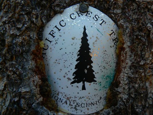
|
|---|
Looking for All Wilderness Vagabond trip reports about the PCT, JMT, Sierra hikes?
Click the image to go to All WV reports about The PCT, JMT, Sierra hikes
|
|---|
|
Map of the route hiked.
This web version from GPS Visualizer can be enlarged
In 2010, I hiked the JMT North to South (link here for the report about this jaunt).
High Sierra Trip Report (link here).
Click here to: see the First ascent of El Capitan, Argosy Magazine, 1959 (10 pages) 22 MB.
Marc Reisner (1993) Cadillac Desert: The American West and Its Disappearing Water,
Revised Edition, Penguin Books
Elizabeth Wenk & Kathy Morey (2007) John Muir Trail, 4ed, Wilderness Press
Bill McKibben – suggested books include: Maybe One, Eaarth, The End of Nature
Bear Boxes in the Sierra Nevada
JMT map pack by Harrison Maps (commercial site)
Post Holer site - maps and resources for planning (PCT site)
Pacific Crest National Scenic Trail Website (FS, NPS, etc. site)
About the PCT - maps
Learning to use a map and compass - instructional page (Ron Watters)
Related Sites:
The Jig Is Up: Supplies of oil and gas are running out
We Are Breeding Ourselves to Extinction (click here for full article)
All WV reports about hiking the Grand Canyon (link here).
Volunteering in the Frank Church River of No Return Wilderness (link here).
How much land is used for livestock? (link here).
Western Watersheds Project - how livestock are the scourge of public lands (link here).
More Truth Than Joke:

|
|---|
a good wall
(Click the image for the full-size image)
|
|---|
|

|
|---|
MAGAvirus mortality factors
(Click the image for the full-size image)
|
|---|
|

|
|---|
Blood on his hands
(Click the image for the full-size image)
|
|---|
|

|
|---|
four horsemen of the MAGAvirus
(Click the image for the full-size image)
|
|---|
|

|
|---|
corporate shill
(Click the image for the full-size image)
|
|---|
|

|
|---|
disapoptamist
(Click the image for the full-size image)
|
|---|
|

|
|---|
people don't like gop policies, so the gop invents hobgoblins
(Click the image for the full-size image)
|
|---|
|

|
|---|
finite Eaarth
(Click the image for the full-size image)
|
|---|
|
|
|---|
fraudit
(Click the image for the full-size image)
|
|---|
|

|
|---|
GOP loon race
(Click the image for the full-size image)
|
|---|
|
|
|---|
map and compass skills or death
(Click the image for the full-size image)
|
|---|
|
|
|---|
Closer is farther
(Click the image for the full-size image)
|
|---|
|