Indian Garden / Plateau Point / Salt Creek / Granite Rapids / Hermit Rapids / Hermit Rest
(March 28 - April 1, 2015)
Text © copyright by Rob Jones; and Photos © copyright by Rob

|
Hermit Hiatus, Part 3: Grand Canyon Trip Report:
Indian Garden / Plateau Point / Salt Creek / Granite Rapids / Hermit Rapids / Hermit Rest (March 28 - April 1, 2015) Text © copyright by Rob Jones; and Photos © copyright by Rob |
|
|
| |||||
|
| |||||
| ||||
Co-Adventurer: Kathleen Jones
Camera: Panasonic DMC-ZS19
Hiatus - a break or interruption in the continuity of a work, series, action, etc. As in, our 'work' of roving the GC in all its grandness. In Anatomy, a hiatus is a natural fissure, cleft, or foramen in a bone or other structure. This is one big ditch.
ERM - Energy Required Miles. A mile is added for every 500' elevation gain or loss. It's a very serviceable method of estimating energy required miles.
Total trip - (per my GPS) of 36.8, total ERM = 64.5.
Click here to go to the original Hermit Hiatus trip report (2008)
and, click here to go to the Hermit Hiatus, Redux trip report (2012)
All WV Grand Canyon Trip Reports can be found here.

| ||||
Day 1. A Verdant Purple Haze: To IG and Plateau Point.
7.5 miles, ERM = 14.
The mnemonic goes like this (read down, use first letter of starting word as
a reminder - from the rim, down):
Know - Kaibab Limestone
Know The Canyon's History, Study Rocks Made By Time.
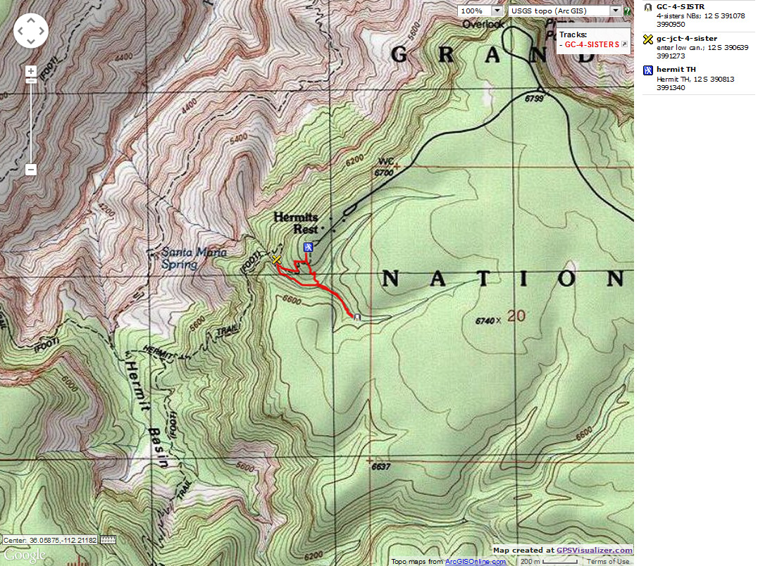
![]() Do you want to save the map for wandering the Hermit Trail and Tonto, 2015? -- Right Click (then save this file: "save
link as..." in most browsers) on this Download link to get
the GPX file from
my GPS - you can then open it in your mapping software. Note - that's a Right Click on this link.
You will get the track for your software shown in the map above.
Do you want to save the map for wandering the Hermit Trail and Tonto, 2015? -- Right Click (then save this file: "save
link as..." in most browsers) on this Download link to get
the GPX file from
my GPS - you can then open it in your mapping software. Note - that's a Right Click on this link.
You will get the track for your software shown in the map above.
The verdant oasis below has a purple glow. It's the Red Buds
interspersed among the newly-leafed Cottonwood trees. A gorgeous purple haze drifts in a verdant
swirl of Cottonwood.
Down. Down more. On the Bright Angel Trail trough the throng of day
hikers we go. It's a pleasant short jaunt to a place where we feel at home. Hey, it was home just a
few days ago.
(link to VIPs at IG report)
Arriving in IG, I go to take after photos of the GCHBA work done last
week. There's a ballroom in the RS (Ranger Station), newly painted clinic and RS, spruced up signs
and trail, and more, much more. We tour the results of our
recent volunteer service trip at IG.
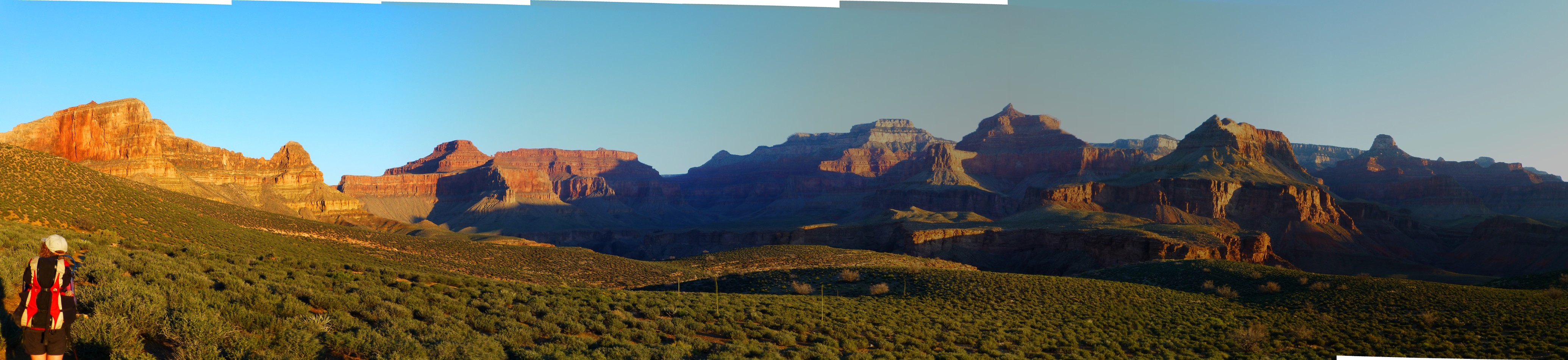
Then, Kathleen wants to go out to Plateau Point. The River growls below.
Today it's more jade green than earlier this week. Off to the East, I hear the cascade of Garden Creek
as it slides to meet Pipe Creek. Hedgehog cactus bloom along with the first Brittlebush. Gorgeous views.
We encounter Ranger Elyssa and chat about adventures enjoyed.
The day is fading and it's time to eat beneath the Redwall Limestone
cliffs, with the background of the first Canyon Tree Frogs singing their Canyon melody. Bats swoop
through camp in the gathering dusk. Home is where you hang your bat.
The - Toroweap Formation
Canyon's - Coconino SS
History - Hermit Shale
Study - Supai Group (including the Esplanade)
Rocks - Redwall Limestone
Made - Mauv Limestone
By - Bright Angel Shale
Time - Tapeats SS
Day 1 photos from Hermit Hiatus, Part 3


| ||||
Day 2. Salty Dog : To Salt Creek, 7.5 miles. ERM = 11.
The froggy in the polished rock pool just a few feet down Canyon chortles
as if to tune up for tonight's festivities. Glorious. We're anticipating a froggy serenade tonight.
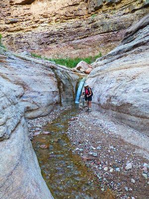
We're hiding out from old sol and enjoying the natural quiet of the slot
below the trail in Salt Creek. Luscious shade and a slight breeze refine the day. Lounging on polished
rock relaxes away the insults of the air tour terrorists.
Earlier, the drone of the air tour terrorists canceled the sound of the
River, the rapids, and most natural sounds. Unnatural is the clatter and intrusive whopping of the air
tour terrorists. Just imagine how horrid the noise is closer to the fly for corporate welfare line, that
is, the edge of the no-fly zone. Atrocious!
The day begins for us at 4:30a. We're on the trail a bit after 6, cruising
along in the cool, going with the sun.
Soon, we settle into the Horn Creek drainage, where cool air also pools.
Time for sunscreen before plying the other side of the contour, which is now in the sun. The radioactive
water in Horn slithers clearly and crisply through the polished rock pools, looking delicious, pristine.
Around Dana Butte the contour-hugging Tonto Tontours. It may not be very
far straight line, yet it's miles on the Tontour.
We stop for a snack where the view continues down River to Hermit Rapids.
Cope Butte can be seen, yet is dwarfed by all the nearby features.
We glide into Salt for solitude.
A sun-warmed bucket bath washes away that salty dog feeling.
 |
 |
 |
 |
 |
 |
Day 3. Granite Rapids Sans Social Skills: 5.5 miles, ERM = 8.5.
We're camped at about 2400 feet.
The River throbs and its surface is stretched glossy smooth at the head
of Granite Rapids. Fidgeting, it growls sonorously, drowning out most other noises. Finally, the natural
nature noises predominate. We're cloistered against the sheer basement rocks in the deep shade of
Precambrian Schists and Zoroaster Granite, with the jade River pulsing against our camp beach. Deluxe.
Spiny Lizards skitter between the sun and shade, maintaining their reptilian temperature in the zone.
The only downside is sharing the area with a large group of hikers and the absence of our picnic rafts,
which seem to be late in arriving. It's 1p and so far, no baloney boat has stopped to serve up lunch.
The day starts with a Tontour from Salt to Cedar and then to Monument,
where we enjoy a snack break. Curling around the Monument spire totem composed of Tapeats SS and Zoroaster
Granite, we drop into Monument Creek and wade the gravel to The River. Duos and foursomes of warblers
twirl through the shrubbery establishing territory, cavorting. Lavender fragrantly blooms, along with
Mariposa Lilly, Paintbrush, Red Bud, Phlox, Blackbrush, Brittlebush, Goldeneye and others unknown. It's
a lazy afternoon along the Colorado.
Then, horrors. A private river party from Washington assails the beach,
akin to an amphibious landing by the US Marines, and the greeting is "Hey, you're in my bedroom!" No,
"Hello, can we share this area?" Not River etiquette, not at all. Outfitted well by PRO of Flagstaff,
with everything but manners or social skills. Ghastly behavior, the base of conflicts on the River.
A significant contrast to our interaction with the AZRA people at Lava during a prior trip. Sure, Mike
was a gem, yet that was pretty much the extent of good graces in this graceless hoard. This being
overrun by superior antisocial numbers certainly lowered the quality of today. Still, we enjoy the
middle night, when things finally quiet down, and River sounds recapture the night.
 |
 |
 |
 |
 |
 |
 |
 |
 |
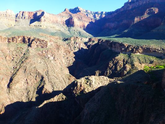
Day 4. Hermit Ho: To Hermit Rapids. 6.3 miles, ERM = 11.
Hues of many flowers glow in the early morning Tontour light, with excelsior
views from the low pass below Cope Butte. Down to refreshing Hermit Creek and through a glittering geological
tour of basement rocks to The River. The mica, quartz, granite, and other sparkly silicas glisten in the early
sunlight.
Scouting up River, we don't find much in the way of campsites. Down River,
we find an aerie camp below a rock wall - with a superb vista of Hermit Rapids. A turquoise bikini babe invites
us to share the camp. Smile.
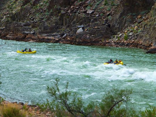
We go to explore and treat water for the rest of today and tomorrow, take a
bath and nap in the shade of an old Tamarisk. The wind is up, so we move our bags from the windswept aerie
to a site near Hermit Creek. The well-appointed aerie is too exposed to wind, despite its other alluring
exposure. While moving, we catch the run of a rafting group as it rollicks through Hermit Rapids.
The wind builds and continues on into early evening, yet we're snuggled into
our tamarisk and cutleaf willow clutch.
| ||||
 |
 |
 |
 |
 |
 |
Day 5. Stairway to Heaven: the Cathedral Stairs.
to Hermit Rest. 10 miles, ERM = 20. Total miles of 36.8, total ERM = 64.5
Slowly I turn, inch by inch, step by step, I approach the Cathedral
Stairs through the Redwall Limestone. Kathleen and I are up before the sun and preparing for the
long haul from River to rim. And it is, a long haul.
Up along Hermit Creek, walking the gravels and scanning for Bighorn
Sheep in the early shadows we walk until it becomes a trail just before Hermit Creek Camp. Out on
the Tonto, the Four 'O Clocks are open and awaiting the sun, as are we. Soon, we're on the long ramp
leading to the Cathedral Stairs, still in the shadow of the East wall, climbing steadily. Whew, we're
in the tight switchbacks of the Cathedral Stairs through the Redwall, which we believe to be the tough
section. By comparison, we find the Supai traverse to Santa Maria Spring more exhausting. Mostly
because it never seems to end, on and on, rolling on. The spring is around the next corner, maybe
the next, etc. Somewhere in this stretch the sun finds us and it's time for sunscreen.
Kathleen and I stop in the Hermit Rest House, lounging behind the
Arizona Grape screen, for a second gorpage. The first gorp stop was along the Supai traverse. The
rest of the hike is mostly in the sun, yet we're high enough and the day is cool enough that the climb
through the Coconino, Toroweap, and Kaibab layers goes smoothly. The mileage and altitude gained is
wearing, however, and it feels good to stow the boots and wet shirt in the Subaru and roll toward a
well-deserved shower on the Colorado Plateau, honoring the Hermit Hiatus once again.
| ||||
 |
 |
 |
 |
 |
 |
Four Sisters Natural Bridges: Found during a day hike off the Hermit Trail.
These gorgeous NBs (natural bridges) were apparently a common feature of the Hermit's
(Boucher) tourist mule rides because the old trail is rumored to have entered and exited The Canyon via the canyon just
below the top portion of the current Hermit trail, the quarter mile near the TH. Here is a video and some photos depicting
The Four Sisters. Apparently, some call these girls the Three Sisters. Yet, there are four NBs, and Three Sisters is
the name of a series of spires in Monument Valley. It's not easy to photograph all four of The Sisters in one image,
so I included a video so you can see for yourself. Better yet, take a day hike to Dripping Springs from Hermit's Rest,
and visit The Sisters on the way back.
Also see the info sheet by Emily Davis, Interpretive Ranger at the GC, and the person who told me the general area
in which to look for the Four Sisters.
Ranger Emily told me about the Four Sisters NBs - here is some info (click here for pdf)
Brief directions - Four Sisters NBs: Walk one quarter mile
down the Hermit Trail, starting measurement at the TH sign. Watch for the low canyon off to your left, going down.
As the trail gets to an easy access, drop into this low canyon and walk up canyon for 0.4 miles, taking the
right canyon at the first branch, and the left canyon at the second branch. NBs span the low drainage.
A more direct way back to the trail can be hiked from the first fork you took going up canyon - just hike North
up the side of the canyon and back to the main trail (see map) - or return the way you came. The whole loop is
about a mile.
On another trip, I found the Four Sisters - here is the movie (mp4; 27mb)
Links:
Click here to go to the original Hermit Hiatus trip report (2008)
and, click here to go to the Hermit Hiatus, Redux trip report (2012)
Maps:
| ||||
| ||||
Books:
Eaarth : making a life on a tough new planet, McKibben, Bill,
Time Books, 2010.
Maybe one : an environmental and personal argument for single-child families, McKibben, Bill, Simon & Schuster,
1998.
The end of nature, McKibben, Bill, Random House, 1989.
A River Runner's Guide to the History of the GRAND CANYON,
Crumbo, Kim, JOHNSON BOOKS 1880 South 57th Court, Boulder, Colorado, 80301
1994.
Other WV reports about the Grand Canyon:
Click here or on the Looking Lizard to go to all WV reports about The Grand Canyon
| ||||
Related Links:
And - Click here to see a Grand Canyon
River Archeology Virtual Tour.
the geology of the Grand Canyon by the NPS
Ranger Emily told me about the Four Sisters NBs - here is some info (pdf)
On another trip, I found the Four Sisters - here is the movie (mp4; 27mb)
More Truth Than Joke:
| ||||
| ||||
| ||||
| ||||
|
Wild Vagabond Main |
Trip Report Index  |
Caveat  |
|---|