|
| |||||
|
Grand Canyon:
Grapevine Galleria, Redux!
Grandview to BA: / Visiting Hance Creek / Circum-ambulation of Horseshoe Mesa / Cottonwood Creek / Grapevine / Lonetree/ Bright Angel Campground / Indian Garden 52.3 miles; ERM = 89 October 3rd to 9th, 2016 Text © copyright by Rob; and Photos © copyright by Rob |
|
| |||||
|
| |||||
| ||||

| |||||
| ||||
52.3 miles; ERM = 89 Co-Adventurers: Solo hike camera: Panasonic DMC-ZS19
Summary: This trip report describes a Tontour, starting at Grandview Point and dropping
down to Horseshoe Mesa and the Tonto Trail before proceeding West to Cottonwood Creek, Grapevine
Creek, Lonetree Creek; then down the South Kaibab to Bright Angel CG before completing the hike
via Indian Garden and the Bright Angel Trail. Along the way, I hiked all three trails from the
Tonto to Horseshoe Mesa.
ERM = Energy Required Miles. A mile is added for
every 500' elevation gain or
loss. It's a very serviceable method of estimating energy required miles. ERM was initially used in Trails
of the Tetons (long out of print) by Paul Petzold, founder of NOLS. It's a wonderfully useful concept and
application. Add one mile for each 500' up AND down to distance = ERM. I use ERMs to calculate what the actual
day is like. It's a very serviceable method of estimating energy required miles. Remember, however, that the
ERMs are estimates because they depend on GPS satellite coverage and math functions.
Day 1: Pondering Page. To Hance Creek on the Tonto Platform:
5.2 miles. ERM = 12. Camp @ 3700'.
Using ERMs does not account for the 'texture' of the route or trail - that
is, rocky, boulders, no trail, slimy mud, etc., yet does help approximate the route.
Tim Wilson meets me at the BIC (Backcountry Information Center) and
shuttles me to the Grandview TH (@ 7400'). The wind is stiff, making for a very cool pack check before
setting off for Horseshoe Mesa and then Hance Creek via Page/Miner Spring.
John of Australia and I talk along the trail as we drop through layers
of rocks made by time. John selected the Grandview trail for his one day hike in The Canyon because he
thought it would be fairly quiet. And, it is. We encounter a half dozen hikers on the way to Horseshoe
Mesa. On Horseshoe, we hide from the wind in the lee of the long abandoned miner cookhouse walls and enjoy
a brief lunch before poking around a bit, then dropping down to Page/Miner Spring on a precipitous and
rarely maintained narrow trail through the Redwall Limestone. The trail twists past historic mining
explorations, one sporting an old pump.
Meeting the side trail to Page/Miner Spring, I drop my pack and John and
I stroll to the spring. Gorgeous clear and crisp water tinkles though Maidenhair Ferns clinging to the
spring recess, where the water is squeezed out at the juxtaposition between Redwall and Muav Limestone.
Classic, many of the Canyon springs are prompted by the Muav.
For John, it's time to climb back to the rim and drive to the Hopi Cultural
Center for the evening. I continue down to meet the Tonto Trail, then East to Hance Creek, where I find
good water and noisy neighbors, who have sprawled their one party across several camp areas. trumpish.
Because the wind is still vigorous, I find a sheltered small site above the
Tonto, nestled in the mesquite, Rabbitbrush, Cliffrose, and other wind cutting brush.
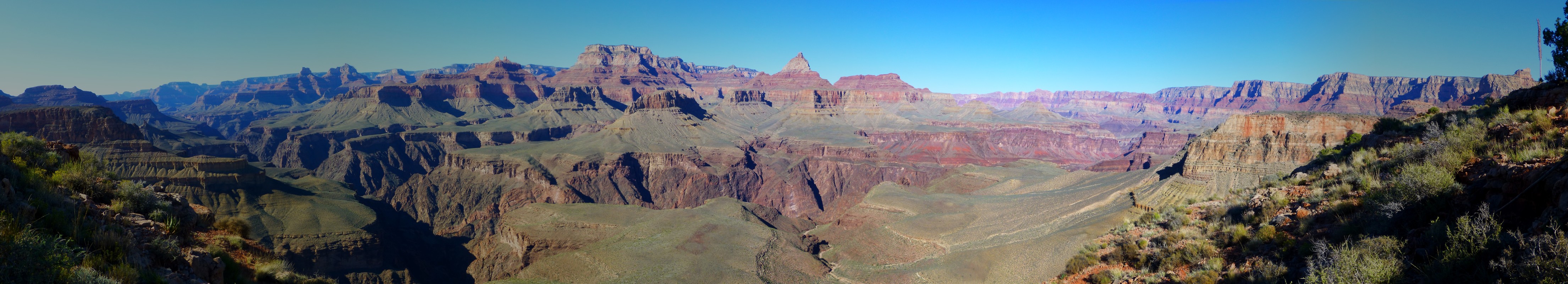
Sadly, Angel's Gate, which is directly across the Canyon, is bounded by a
gray cloud backdrop, limiting photographic possibilities.
The clouds race by overhead and the ground level wind swirls about, urging
me to make an early appointment with the tent. Striving for an early tent time, I am reminded how far into
Fall I am as it gets seriously dark before 7 p.m.
And, more Canyon Time is exquisite and fine, I muse. Counting this and the
upcoming VIP (Volunteer In Park) trip (click here for this VIP report)
I will have backpacked 27 days this year in The Canyon. Then, there
are the day trips on the South Kaibab - Tonto -BA loop, the Hermit Trail, day hikes off the North Rim to
Roaring Springs, Widforss, etc. and there are a host of luscious Canyon miles about which to muse.
How long will we have access to wild public lands? With the rise of selfish
trumpmania, which is just another reincarnation of corporate and 1% welfare, the republicans' plans tirelessly
include privatizing public land. This meets the mantra of republican lies to their followers, who unerringly
vote against their own best interests. Socialize the loss and privatize the gain! Of course, there are far too
many corporate democrats too. Hillary is one of these ilk. Yet, the basic social fabric will remain with
Hillary, while with the donald all will be sacrificed to an amoral/immoral corporate cabal of socio- and
psychopaths while the middle class get the shaft. Note historical data - republican administrations shift the
cost to the middle class and poor while creating huge public debts to enhance the 1% and corporations. It's
corporations that are cruel, inhuman, and by nature amoral and immoral (their quest is only money, more and
more), yet rank and file republicans blame the government while the tax cuts go to the rich and corporations.
Amazing and difficult to understand how people forget bushco, reaganomics, and how republicans shifted the
wealth, draining the middle class and forcing many of them into poverty (with the tacit or active assistance
of a few corporate democrats, sigh). A corporation took my job, stole my health care, took the social
security/medicare I paid into -- blame the government! What!? OK, enough of this, it drains the color
from the kaleidoscope Canyon.
Day 1 Photos - Grapevine Galleria 2016


Day 2: Cottonwood Caper. Contour on the Tontour: to Cottonwood
Creek (5.2 miles; ERM = 7); and circumnavigate Horseshoe Mesa (5.5 miles; ERM = 11); total miles of 10.7;
total ERM = 18). Camp @ 3560'.
The morning glow touches Angel's Gate, then slowly spreads to the Western
Redwall. Delightful.
I'm lounging in my slickrock Coconino Sandstone bucket seat and watching
the early rays play across my truncated view of The Canyon.
Then, it's contouring on the Tontour. Yes, the Tonto Trail strives to
stay on the contour (or level line on terrain or a map), thus the moniker, Tontour. Of course, this is
also a tour on the Tonto, so a double meaning here.
I realize it's 9 a.m. when I hear the distant, yet intrusive, thundering
rumble of the air tour terrorists. Horrid! The selfish and self-serving chambers of commerce intrude
into the land set aside because of its soundscape. What!
It's a Tontour on the contour around Horseshoe Mesa and into Cottonwood Creek.
No creek. Where is Cottonwood Creek? Oh, oh. I go in search of water,
finally finding a solitary pool about 1,000' above where the Tonto Trail crosses the drainage.
Bob of Maine arrives and he tells me about water at Grapevine and in Lonetree.
I drag a bucket of water back to camp and filter all of it before
returning for another bucket full, which I intend to warm in the sun (bath time later).
After setting up camp, I load the pack as a day pack and backtrack to
the old trail that climbs to the fin of Redwall North of Horseshoe Mesa (the horseshoe-shaped crest of
the mesa). This is the middle route to Horseshoe Mesa from the Tonto. It's about 1.5 miles to the base
of the old trail, then a direct route up to the mesa, the trail showing signs of long ago construction.
After the 1,000' climb, now atop the Redwall, I turn North and walk to the tip of the fin, where there are
panorama opportunities.
Then, hiking the fin South, I'm back to the old cook house location, near
the junction of the trail down into Cottonwood Creek, passing the route to Cave of the Domes along the way.
Tempting, and I have my headlight, yet there's just not enough time.
The trail off the mesa into Cottonwood Creek is steep and filled with
rolly pebbles. Slow going.
After the trail levels some, I pass the arm coming in from the West and
containing a spring. Crossing though this arm of the canyon, I see a dribble of water, then two campers,
then Bob of Maine. The water disappears just below Bob's camp.
Bob and I chat more, then I'm getting chilled and light is fading, so off
to camp I go with my flattening feet.
I start dinner soaking while bathing in the last light, and eat dinner
accompanied by billions and billions of stars. Ursa Major (The Great Bear), the Big Dipper, lounges on
the Tonto Platform across The Canyon and points the way to the North Star.
 |
 |
 |
 |
 |
 |
 |
 |
 |
Day 3: Grapevine Galleria. To Grapevine Canyon:
5.5 miles. ERM = 8. Camp @ 3612'.
It's so peaceful and quiet under my trio of junipers and so lovely
watching the golden sunlight slide down the Redwall above and across The Canyon, that I find it
difficult to do anything but enjoy the morning. Yet, it will be heating on the Tontour. Not just yet,
I muse. I pause to allow the tent bottom to dry while contemplating the day and The Canyon. Delightful,
and no air tour terrorists, at least not yet, wholly sponsored by your chamber of commerce. Unfettered
growth, the ideology of the cancer cells. Scourge.
Back on the Tontour, I contour around to the West arm Cottonwood spring.
Dry. Continuing, I can hear the rustle of wind rippling through the wings of the swifts flying
acrobatically, barrel rolling over the Tapeats Sandstone ledge, showing off with gusto. I can hear the
rumble of The River careening through Grapevine Rapids, interrupted by the intrusive jet overflights
and the distant drone of dollar decibel terrorist helicopters that have been declared soundless by the
commerce chamber's lackies mccain and reed. Selling a treasure to money changers. Fools and minions.
Representing money and more money and little else. Corporations are amoral and immoral. And guess how
these "people" might vote?
Dropping
down part way through the Tapeats on the route which may go to The River produces a good view of the milk
chocolate River fidgeting through the constricting walls of dark chocolate nougat basement rocks. Humm,
I consider stopping for a tortilla lavishly slathered with yummy hazelnut spread. I wait for the first
Grapevine spring to do so.
Now, about 1:30p., I'm lounging in the shifting shade of a juniper at
the Tontour crossing of Grapevine, the East arm. It's lunch #2. I walk up canyon looking for water,
which trickles near some tent sites 800' above the trail. These camps are probably better protected from
a rising wind, which is propelling fluffy cumulus clouds from the West, I consider. And perhaps they are
recipients of early shade because the canyon walls are more narrow up here?
Exploring down Grapevine, it's a bit sketchy initially getting off the
ledge and into the canyon proper; this involving a short down climb. Then it's a pleasant walk through
small slickrock bowls and past an overhanging spring dripping through Maidenhair Ferns. Spectacular.
A stream of clear water begins. As the canyon widens it is chocked with bowling ball rocks, becoming
less interesting. So I return to the camp area where this canyon forks, to gather water and set up camp.
The wind continues to pulse and shriek, yet this camp offers decent, albeit not complete, protection.
As the bursts of wind buffet my laundry and The Canyon colors dull in
the descending dusk, I realize that I've seen no one today. Except for the swifts, dragonflies, song
sparrows, tadpoles, tiny red frogs, bats, pinyon jays, lizards, et al. What wonderful company for a
Canyon quest.
 |
 |
 |
 |
 |
 |
 |
 |
 |
Day 4: Lone to Lonetree. To Lonetree Canyon:
9 miles. ERM = 12. Camp @ 3580'.
I unfurl the umbrella not long after sweeping around the first corner
of the Tontour out of Grapevine Creek. It feels much warmer than yesterday.
I meet a woman going toward Grapevine and she's toting an umbrella. Not
very talkative or engaging, she tells me info that is a trumpish of the truth (totally false), such as
there is water 300' up canyon in Boulder. Not helpful.
I trundle along the Tontour, hoping to see some Bighorn Sheep. Just scat,
and a few days ago too. I meet Larry (of the UK) and Liliana (of Poland) who are visiting The Canyon for
the first time. Yikes, they have lugged water from the South Kaibab TH and still have a gallon, after
camping at Cremation and at Lonetree. Their spirits are good but their feet flat and other parts aching,
and a view of Grapevine Rapids is what they need, along with a break. We talk about water and camps at
Grapevine and Cottonwood, which they will visit before exiting The Canyon via the Grandview Trail.
I'm definitely ready for a break myself, my feet exclaim, when I've hiked
about 6 miles to Boulder. I pull up a rock under a helpful Singleleaf Ash and enjoy lunch #1. Delightfully
deluxe. It's very decent in the shade and the views are close Redwall and good.
I've moved on, hiking the Tontour, and now I'm sheltered in the lee of the
sun next to a cheese grater limestone boulder, enjoying a foot break with one more push to Lonetree.
The looming hulks of Zoroaster and Brahma Temples fill more and more of the view. Lunch #2, and more
excellent hazelnut creamy spread on a fat tortilla. Excellent indeed.
Rolling into Lonetree, I see few spots to camp and some red mud puddles.
Not good. Dropping the pack, I take my bucket and all the empty bottles (they're all empty now) and
start down canyon in search of decent water. It's discouraging. Then, a lone Cottonwood (the lone tree?)
and a brief trickle of good water, now over 20 minutes of hiking below the Tontour crossing. Yippee.
Filtering full all bladders, I slog back to camp and start dinner. While dinner soaks, I partake of a
bucket bath and set up the rest of camp. Crimson slips off Zoroaster as I put on the evening clothes
for dinner. It appears that I am the only person in Lonetree tonight. Lone to Lonetree.
 |
 |
 |
Day 5: Tontour to BA. To Bright Angel Campground:
8.9 miles. ERM = 15. Camp @ 2480'.
The rustling, fidgeting burble of Bright Angel (BA) Creek soothes
me and perhaps calms the hyperactive pace of R2 (rim to rim ruffians)? Nah, the R2 focus on the
"me, Me, ME!", yet mostly don't experience The Canyon, except as a personal race track, making a
good study of their shoelaces. Anyway, there's too many of them, and there's too few hiking ethics
in this R2 hoard.
Still, the BA Creek rolls on, nearly to The River in Bright Angel
CG and here producing an oasis of luxuriant vegetation, thanks to the careful ministrations of Sjors,
the BA permanent volunteer, supplemented by the annual work of VIPs (Volunteers In Park) of the GCHBA
(Grand Canyon Hikers and Backpackers Association). We of the GCHBA are again hiking in to BA in a bit
over two weeks. Here's the report of this volunteer service project, Finding Phantom. Link.
The day starts with more Tontouring from Lonetree to Cremation to the
scenic toilet at the Tipoff. The trail gets lost in the fractured rocks as it undulates through the
branches of Cremation, and it plunges through canyons here rather than contouring. Not Tonto-esque
at all.
From the Tipoff, it's three miles of downhill to BA. And, it's quiet.
Amazing. Perhaps I'm ahead of the crowd? Ranger Betsy later tells me that I was fortunate to hike
in the lull, between the frenetic early and late R2. Super serendipity.
I have my choice of campsites and drop the pack for lunch #2. Then
to the cantina of Phantom Ranch to write a few postcards, to the sewage treatment facility to check
the number of buckets we left for storing food (left only 7) for the
upcoming VIP (Volunteer In Park) trip (click here for this VIP report)
volunteer service project.
And to attempt a video of the milk chocolate sludge that is currently The River. Thunderstorms in the
long tributaries of the Little Colorado are pumping tons of silt and mud into The River.
Feeling tired, I return to camp to watch rocks made by time and am
lulled into a near stupor by the sound of tumbling BA Creek water. After dinner, the meditational bliss
is superb on the bench above Bright Angel Creek.
For rocks made by time, the mnemonic goes like this (read down, use first letter of starting word as a reminder - from the rim, down):
Know - Kaibab Limestone
The - Toroweap Formation
Canyon's - Coconino SS
History - Hermit Shale
Study - Supai Group (including the Esplanade)
Rocks - Redwall Limestone
Made - Mauv Limestone
By - Bright Angel Shale
Time - Tapeats SS
Know The Canyon's History, Study Rocks Made By Time.
 |
 |
 |
 |
 |
 |
| ||||
Day 6: Indian Garden:
4.9 miles. ERM = 8. And to Plateau Point. 3 miles. ERM = 4. Total miles 7.9. Total ERM = 12. Camp @ 3850'.
The breeze ruffles the fig and pomegranate and Cottonwood leaves while
the outline of puffy clouds appears overhead. It's morning in BA Camp, and a delightful one too. I
can see the headlights bobbing and hear the R2 loudly rehearsing their scripts for the False Bravado
(AKA face book) over the natural quiet of Bright Angel Creek. Praise bushco, most of the R2 are on
the trail across the creek. And, hey, I'm writing notes for my own version of false bravado, and hope
it's more entertainment and information than bravado.
Now, back to the real world.
Up through rocks made by time; basement rocks, then layer upon layer,
younger and younger. But today I'm going to Indian Garden, so it's basement rocks, the Tapeats Sandstone,
and part of the Bright Angel Shale.
For lunch it's free range hazelnut spread, peanuts, oreos, pretzels, stuff
like that. Yummy.
Plateau Point beckons, and I agree. The clouds close in and the vistas
are compromised, yet it's still grand.
Just back from the Point, lightning, thunder loud enough to prompt me to
cover my ears, and a pattering of rain interrupts lunch #2, and it's good to be under the IG ramada.
The rain bursts forth intermittently and I'm happy to have organized almost
everything into the rocket boxes and brought the empty pack under cover too. It's cool enough for a jacket.
Ranger Meghan stops by during her campground tour and points out where two
lightning strikes have brush smoldering. It drizzles a bit more and the humidity is high, so there seems
little likelihood of a big fire.
It's a dark and cloudy evening in IG Camp.
 |
 |
 |
Day 7: Rim Time. To BA TH:
5.1 miles. ERM = 12.
The pink glow slides down the Redwall escarpment backing IG camp.
Other hikers seem to be in a big hurry to leave this splendid place. I doubt that the temperature
warrants that urgency.
Rising to the South Rim, I find the trail in good condition because
the fine youngsters of the American Conservation Corp are actively working on it. It's a lovely hike,
but for the rim-to-rim runners who unethically and discourteously yell "I'm coming through!" and bump
into and off anyone on the trail; treating people as bowling pins, inanimate objects. Typical; trumpentine.
Bullying and aggressive behavior have been normalized by the people of trumpville. Of course, rim-to-rim
runners are incompatible with the Park mission of preservation of the natural and enjoyment by all but
the selfish R2.
The crowds thicken above the 1.5 mile rest area and soon I'm strolling
the rim back to the BIC for the drive home, reminiscing about another worthwhile Grand Canyon adventure.
 |
 |
 |
| ||||
Links:
| ||||
Other WV reports about the Grand Canyon:
Click here or on the Looking Lizard to go to all WV reports about The Grand Canyon
| ||||
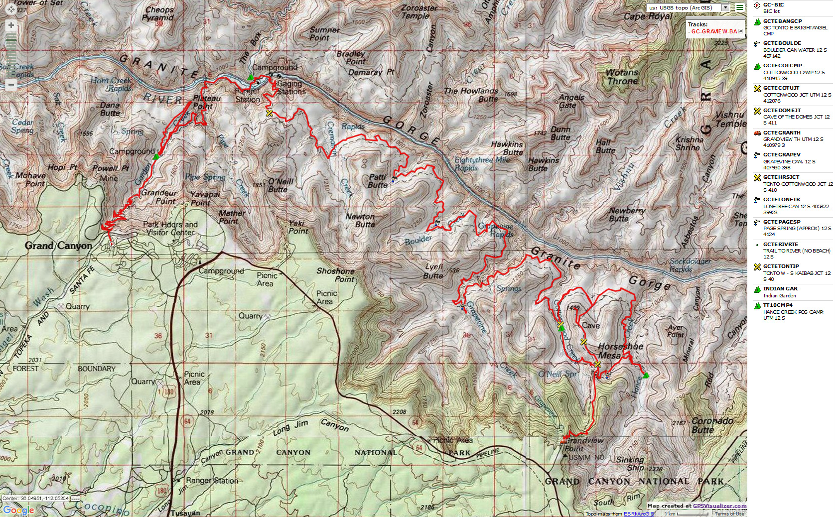
Map:
| |||||
Related Links:
The first Grapevine Galleria trip report (2009)
the geology of the Grand Canyon by the NPS
Eaarth - Living on a fundamentally altered planet by Bill McKibben
More Truth Than Joke:
| ||||
| ||||
| ||||
| ||||
| ||||
| ||||
| ||||
|
Wild Vagabond Main |
Trip Report Index  |
Caveat  |
|---|