
(Click the image for a full-size view (26k); Photo by Rob)
|
|
|---|
|
Brent and Ring Arch
(Click the image for a full-size view (26k); Photo by Rob) |
SUWA has something to say about Lockhart Basin and the active neglect it is receiving from the Bureau of Leasing and Mining (BLM). See SUWA at:
http://www.suwa.org
|
Wild Vagabond Main |
Trip Report Index  |
Caveat  |
|---|
The Trip:
Night 1: Windy Arrival: We (Brent Laughlin, and I) bolted out of Smog Lake. It's an early out on Tuesday evening, as we escaped the deconstruction of I-15, headed through Price and Moab (yuppies and yuppos, everywhere) and into the night. We would drive all the way to the Indian Creek/Lockhart Basin Road just outside The Needles District of Canyonlands N.P. The wind blew our tents like sails on the slickrock ocean as we attempted to set them up in the light of the hazy full moon. It's nearly midnight as we close up the tent, and, buffeted by the wind, are rocked to sleep.
Day 1: Wind Rim: In the morning, we skulked over to the Needles Outpost for some coffee to accompany our on-the-road breakfast of muffins, fruit, and left-over snacks from last night. Thin cloud trails coursed across the robin egg sky. We marveled at this vaporous artistry and ignored the prognostication. After obtaining our trip permit that we had previously reserved, we drove around to the Elk Mountain Road near Dugout Ranch and then up this dirt road to over 7,000' and the trailhead in the shade of Cathedral Butte. The wind was tearing over the rim as we peered through the edge of the pygmy forest and down into the distant Upper Salt Creek Canyon.
It's 1000' down to dry Salt Creek and 4 miles total to Kirk Cabin and our SC1 (Salt Creek camp #1) camp. Along the way, we wandered a mile or so through old reeds and marsh, an incongruent feature in this dusty desert. The wind shrieked, welcoming us to the interior of Canyonlands and clogging my stove pump with Jurassic sand.
|
|---|
|
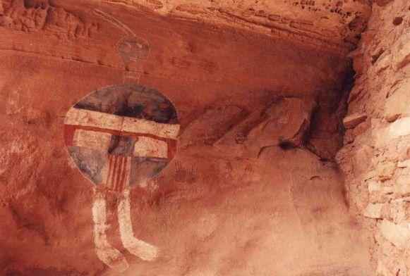
The Unbelievable All American Man
(Click the image for a full-size view (20k); Photo by Rob) |
Day 2: Icy Archaeology: We awoke to gray clouds and more wind. It had gotten cold enough to freeze the water in the pan on the stove. Ahh, but what a day! We saw fresh Mountain Lion tracks, an Anasazi metropolis replete with pot shards and matates, lots of other ruins, Kirk Arch, another arch high on a distant fin, Wedding Ring Arch!, and all this before lunch.
We lumbered on, lunching at the astonishing, astounding, and amazing All American Man pictograph, a surrealistic painting that seems unlike any of the others in the area. It most likely gets its name from the red, white, and blue pigments adorning this odd little guy ensconced in a cave-like suspended alcove that also houses some old food storage ruins. Small hand-prints accompany the Man.
Continuing, we soon encountered the Four Faces Pictograph under the distant watchful eye of what we initially thought was Fish Eye Arch (it was just another unnamed 'natural arch' designated on the map). "What do these pictos mean?" asked Brent. "Perhaps this means one should not stand under the overhang, or be hit in the head by a rock" we mused. There is so much to see, and we were quite certain we had missed lots of good stuff.
SC3 is a "marginal camp" the ranger had told us. "We had a difficult time locating it because of how much archeological activity there is in the area," he continued. This spiel had sold us, and the distance was right for a planned day hike to Angel Arch. We grew anxious for upright walking without packs, and soon after found the post designating SC3 camp. After establishing camp mostly in the 4-post boundary set-up by the National Park Service, we enjoyed a quick shower accompanied by snow flakes on the breeze, followed by snow squalls.
|
|---|
|
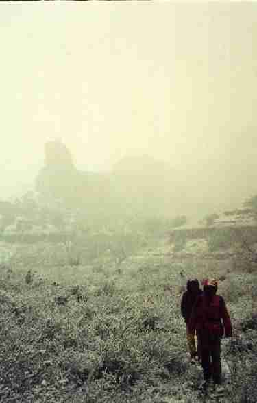
White out on the return to camp
(Click the image for a full-size view (12k); Photo by Brent) |
Day 3: Snow Squall, or what! A skiff of fluffy snow slid off the Sphinx tent, startling me to the prospect of real, bad weather. During breakfast, the squall rolled in, gradually engulfing the distant, then not-so-distant buttes. We debated leaving, but opted to hike toward the next panel, then decide. The ridges disappeared, reappeared. We were lulled when the snow abated upon our return to camp. So, we packed for a long day hike to Angel Arch. About the time we reached Upper Jump, the storm jumped in and stayed with us all day. We sloshed on toward Angel Arch. After a cold lunch in a dingy alcove, we considered the visibility, our wet boots, our eagerness to endure, then returned to camp.
We invested the afternoon and evening camped in the tents, reading, shucking snow from the tent flies, peeking out at the continuing snow, and eating lunch foods for dinner.
|
|---|
|
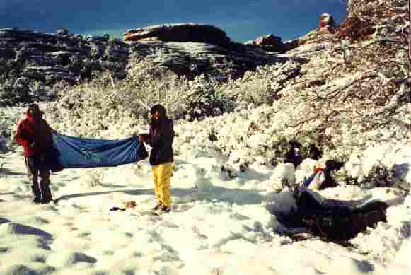
Shaking the snow load
(Click the image for a full-size view (21k); Photo by Brent) |
Day 4: White Out, Mud Out, Drive: I could see blue sky bordering snowbound slickrock as I pushed away accumulated snow from the bottom of the tent fly and peeked out. Getting out of the tent was a chore not easily entered into because it was cold and each movement near the door brought some cold snow coursing off the fly and onto various body parts. But, we had been in the tent for quite awhile and we wanted out, and now. The stove was primed with denatured alcohol, and soon it was purring away, melting the head of ice in the pans. The exposed water bottles were frozen, but the water bag was mostly water because it was insulated by approximately a foot of snow. We hustled through breakfast and packing and then... Where is the trail? Brush laden with gobs of snow had collapsed, obliterating the trail. We headed out with apprehension. Would we find the trail or wander most of the day? What about the road? It must be impassable. Brent was concerned about the trail. I was more worried about the road.
We raided the lunch bag for plastic sacks to cover the socks, hoping to ward off the wet. Wearing anoraks and rain pants all day, we bulled through the bushes collapsed on the trail. As I was doing this, a bull rush poked me in the lip, punching a neat cookie-cutter hole in it. Ouch. After several false starts through the brushy areas, we got rolling and found the key-hole access through a rock peninsula and popped out into the park near the All American Man. Here the going was easier, and we strolled along to Kirk Cabin without big route errors. "Such scenery!" we raved, marveling at the named and unnamed arches, ruins, and pictos. It's paradise, dusted with snow.
We paused for lunch on the slick-n-slide where the spring water flows into Upper Salt Creek. It's cool, but sunny, and it's great to have off the sodden boots. Then, back on the trail, which we quickly lost while trying to navigate across the open expanse surrounding what must be the springs. We even paused to consult the map, thinking that we might have gone into the wrong canyon arm. No, we're in the right canyon, but tiring. On and off the trail, we finally reached the sign declaring all the awful things one cannot do in the Park. Here, we began the knee-deep, at times, snow climbing to the rim. It was a slog.
At last, we're peering down into Upper Salt Creek from the winter wonderland of the rim near Cathedral Butte. We made it, and all in one day. After clearing 10" of wind-packed snow from Brent's Rodeo, we noticed that the only tracks on the road were from a few wandering elk. Yikes, what does this mean? Will we be stranded here for another night or more? We negotiated the 16+ miles of snow, dirt, and slimy clay mud to the tarmac, snow on the first few miles, firm snow grinding on the bottom of Brent's Rodeo, then, that awful 3 mph sideways helpless slide on the wet clay. Surprisingly, the bottom few road miles were nearly dry. We were also surprised to see that the stream crossing near the road had been graded and that the water level was low.
Whew. We began the anticlimactic drive into Moab, where we encountered the appalling, gruesome, horrendous, ghastly hordes of boneheads involved in the jeep safari. These hopelessly misguided mechanized assholes are attempting to destroy what remains of Utah's backcountry. The vehicles were so thick and so unruly that we saw five vehicles stopped by police in the time it took us to eat a snack from the infamous City Market. We decided we had seen, heard, and smelled enough of this destructive throng, so we continued over Soldier Summit, accompanied by some vagrant snow squalls. It was a late arrival in Smog Lake, where we began drying heaps of soggy equipment and dreaming about a through-hike of Upper Salt Creek.
Epilog: Several weekends later, while visiting Capitol Reef NP, we encountered one of the rangers we had talked with in the Needles District. He had been reassigned to Capitol Reef. He told us that one of the backcountry rangers had been stranded for an extra day in Upper Salt the same weekend we came out, and that other folks had been unable to get up to the trailhead. We just couldn't understand how this could happen.
Please read the caveat and take action to save our remaining wild bits.
|
Wild Vagabond Main |
Trip Report Index |
Caveat |
|---|