Magnificent Muffin Mania, Redux:
GCHBA Volunteer Service Project - in Grand Canyon NP /
Grand Canyon Hikers and Backpackers Ass. (GCHBA) / Painting Rest Rooms, River RS / Rebuilding the Compactor Shed/
and much more
(March 12 - 22, 2018 )
Text
© copyright by Rob; and Photos © copyright by Rob Jones
|
 |
Co-Adventurer VIPs: Annette A., Tom B., Barry B., Holly B., Kathy H., Mike H.,
India H., Bill J., Rob J., Roger S., Becky S., and Tim K. Rebecca from the NPS VIP Office joined us for a day.
Mule packing by packers of the NPS
(National Park Service).
Site-based planning by Elyssa S. and Jeff S. (with thanks to Debbie B.,
Canyon Ranger District; Todd N., NPS)
GCHBA planning and organization by Rob Jones, GPP-SP
(Grand Penultimate Poobah of GCHBA Service Projects).
VIP is Volunteer In Park.
This volunteer service project was supported by the NPS people who put the "Service!"
in NPS; and by the members and Board of the GCHBA (Grand Canyon Hikers and Backpackers Association). Thanks for
your support of our precious public lands.
camera: Panasonic DMC-ZS60
Note: the opinions in this report are not necessarily those of the GCHBA or its Board.

|
|---|
Into The Canyon, Day 1
(Click the image for the full-size image)
|
|---|
|

|
|---|
Verde along the Tonto, Day 1
(Click the image for the full-size image)
|
|---|
|

|
|---|
Tonto Silhouette, Day 1
(Click the image for the full-size image)
|
|---|
|

|
|---|
India totes in style, Day 4
(Click the image for the full-size image)
|
|---|
|

|
|---|
Flannel Mouth Sucker Swirl, Day 6
(Click the image for the full-size image)
|
|---|
|

|
|---|
The Group, Day 8
(Click the image for the full-size image)
|
|---|
|

|
|---|
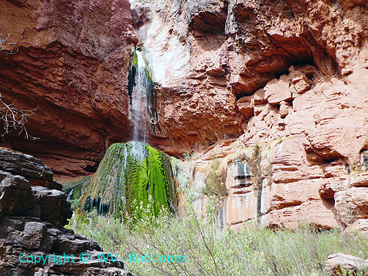
Ribbon Falls, Day 9
(Click the image for the full-size image)
|
|---|
|

|
|---|
Cloud pattern, Day 10
(Click the image for the full-size image)
|
|---|
|

|
|---|
Sand swirls in The River, Day 10
(Click the image for the full-size image)
|
|---|
|

|
|---|
Redwall morning glow, Day 11
(Click the image for the full-size image)
|
|---|
|
|
|---|
Movie: video 3: Ribbon Falls, 20mb, Day 9
(Click the image to see the short video)
|
|---|
|
ERM = Energy Required Miles. A mile is added for
every 500' elevation gain or
loss. It's a very serviceable method of estimating energy required miles. ERM was initially used in Trails
of the Tetons (long out of print) by Paul Petzold, founder of NOLS. It's a wonderfully useful concept and
application. Add one mile for each 500' up AND down to distance = ERM. I use ERMs to calculate what the actual
day is like. It's a very serviceable method of estimating energy required miles. Remember, however, that the
ERMs are estimates because they depend on GPS satellite coverage and math functions.
Using ERMs does not account for the 'texture' of the route or trail - that
is, rocky, boulders, no trail, slimy mud, etc., yet does help approximate the route.
See more information about ERMs at the end of this report.
Overview: This is another report about a GCHBA
(Grand Canyon Hikers and Backpackers Association) volunteer service project in The Canyon. This time,
our group of 12 VIPs (Volunteer In Park) worked at the Phantom Ranger
Station/BA (Bright Angel) area, painting the River Ranger Station (inside and out) and SAR storage unit, the
Delta and Campground
Rest Rooms, rebuilt the compactor shed and painted it, rebuilt a valve house box, built tables and a book shelf,
refinished the Bunkhouse cabinet doors and table, and applied linseed oil to infomation kiosks and roofs and
the Phantom Ranger Station fence, among other tasks. This group contributed 577 volunteer service hours to
Grand Canyon National Park during this project.
I hope you enjoy the Muffin Mania photos and such, and that you are all over your
congresspeople to properly fund and support and care for our public lands, Rob, GPP-SP (Grand Penultimate
Poobah - Service Projects).
|
GCHBA Task List, Bright Angel CG/Phantom RS, 3-2018 (pdf)
(Click the image for the document)
|
|---|
Day 1: Roundabout to the Garden (March 12th). To Indian Garden
via the South Kaibab and Tonto Trails. 9.5 miles; ERM of 17.
The verdant Cottonwood glows green against the red buttes of the North
Rim as we round Burro Spring on our way across the Tonto Platform. Holly, Tom, and I are lilting the
Tonto, passing 12 Mule Deer grazing in the fading light. It's been a long day of preparation and hiking.
For me, it all starts early with final packing of the food box and the
backpack, followed by the drive to The Canyon, where Holly and I meet the other VIPs (Volunteer In Park)
of the GCHBA, Grand Canyon Hikers and Backpackers Association. Next, part of our group sorts food and
group gear for Magnificent Muffin Mania, balancing the weight of the banana boxes, which will be muled to
Bright Angel/Phantom Ranch tomorrow.
Finally, we're ready to hike. Some go directly to Indian Garden via the
Bright Angel Trail and three of us ride the NPS bus to the South Kaibab Trail and start in this way. It's
initially crowded and the going is slow. We're picking up trash along the way.
At the Tipoff we glide farther down the trail to where we can see into
Bright Angel Campground, glimpse and hear The jade River and eat a late lunch on the smooth sandstone
where the Tapeats layer tips off, into the abyss. Eponymously, it's called The Tip Off.
We roll into IG, Indian Garden, campground just in time to set up tents
before dark collapses. A Screech Owl hoots his hootage to the blazing night sky.
Day 1 Photos- VIPs at BA, 3-2018
Day 2: Old BA. To BA via the Old BA.
Clear Creek Trail to the CCC Benches. 8.5 miles; ERM of 15.
The gap in the granary peers down on Tom, Tim, and me as we lilt down
through the Tapeats SS on the Old BA, Bright Angel. After an enjoyable night sky evening at IG we're
bound for BA to begin our VIP tasks. The Old BA swirls downward, switchbacking under the historic
telephone line and along an historic Native American route, dropping through the Tapeats SS (SandStone)
and the top portion of the basement rocks (Zoroaster Granite and Vishnu Schist).
There are issues with the water because the Transcanyon Pipeline has
developed yet another leak. So, the water is off in the campground, and later the Bunkhouse. Thankfully,
the Flannel Mouth Suckers are forming spawning pods in well-watered Bright Angel Creek. Congress will
create a yuge national deficit by granting unearned corporate welfare to big banks, big pharma, corporations,
wallstreet, the very uber wealthy, yet they won't fund the replacement of the pipeline. Nor will congress
require corporations et al., to do anything in return for this largesse. This is yuge.
Tim, Bill, Annette, and I visit the Phantom Ranch cantina for a celebratory
beer before hiking up the Clear Creek Trail in search of a cell signal. We close out the evening with warm
brownies in the Bunkhouse. Thanks Annette and Holly. Deluxe.
Bats swirl through hiker midnight (9 p.m.) yet few of us VIPs are upright
at this late hour. I sleep on the screen porch, where the burble and rustle of fidgeting Bright Angel Creek
accompanies cool air sliding down toward The River in the gulch created by the Bright Angel Fault. Superb.
Day 2 Photos- VIPs at BA, 3-2018
|
|---|
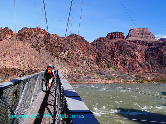
Movie: video 1: Crossing the Silver (BA) Bridge, 45mb, Day 2
(Click the image to see the short video)
|
|---|
|
Know - Kaibab Limestone
The - Toroweap Formation
Canyon's - Coconino SS
History - Hermit Shale
Study - Supai Group (including the Esplanade)
Rocks - Redwall Limestone
Made - Mauv Limestone
By - Bright Angel Shale
Time - Tapeats SS
Know The Canyon's History, Study Rocks Made By Time.


|
|---|
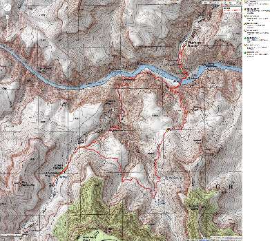
Map - IG to Old BA Trail to BA and up via Miner Route to Tonto - 13 mi
(Click the image to see the map)
|
|---|
|
Day 3: Navajo Brown, All Around. 4 miles; ERM of 4.5. .
The early morning passage of the concession mules wakes me to a pre-dawn
blush on the tip of the rim. It's time to wake up and smell the muffins (blueberry today).
Tim and I tackle the cleaning preparation of the campground and the
delta bathrooms, discovering an abandoned sleeping bag, fluffy slippers, and MREs (Meal Ready to
Eat - military ration, also discovered by the rock squirrels). Disgusting. With the Transcanyon
Pipeline out of commission, we try to rig a sump pump to use to spray off the dust and dirt-encrusted
walls of the rest rooms. It fails and we resort to buckets of water and brooms.
As we begin to paint the exterior of the delta rest rooms, the wind
cranks up to 40 MPH and dust abrades my face and embeds grit, sand, leaves, etc in the freshly applied
Navajo Brown paint. Ick.
Day 3 Photos- VIPs at BA, 3-2018
Day 4: Stormy Pulsing. 4 miles.
I'm searching and searching for my shorts. Where have they gone
and how? The how is obvious, propelled by vicious winds. Yet where? After a very long search, I
find the flying bloomers scrunched behind a water filter box, wedged against the screen porch screen.
Blueberry muffins again today. Yahoo.
OK, now back to work painting the delta toilet. Rain, sun, graupel,
wind pulses foul the work day, intermittently.
At lunch, we throw some wet clothes in the dryer during the snack.
Ahh, a hot VIP shirt to warm the Canyon wet one.
Then, back to painting and dealing with storm pulses.
The crew gathers in the luxurious (except for the water restrictions)
bunkhouse for dinner and story telling, each tale more fanciful than the previous one. And louder too.
Day 4 Photos- VIPs at BA, 3-2018
Day 5: Rainforest. 4 miles.
A triple berry treat is being baked by Baker Barry. Berry bodacious.
Another round of muffin mania.
The Black-throated Swift barrel rolls above the delta toilet as
I paint the rainforest green trim, finishing the exterior of this toilet.
Mike and Kathy are rebuilding the compacter shed. Holly and Tom
are making tables from old Park signs. Annette is painted the cabinets in the bunkhouse. Roger,
Bill, and Tim are painting the campground toilet exterior while Barry rebuilds the valve box near
the River Ranger Station. India is hiking out, while Becky hikes into The Canyon.
Cabinet doors are installed as dinners are prepared.
The wicked dark thirty wind blows lose clothing, sleeping bags,
assorted unanchored items about the Bright Angel drainage, portending an unsettled evening.
Day 6: Wrestling the Sign. 7 miles, ERM of 8.
A thunderous clippety clop of mules wakes me as the skyline
of the South Rim lip can barely be discerned.
Blueberry muffins, once again and yummy too.
Holly and I, with help from Tom, and also Rebecca from the VIP
office wrestle out the old sign and install the new sign case on the North Kaibab, just beyond the
scenic composting toilet. Back and forth we walk for tools, and again, and again. We have
enough difficulties that it becomes a struggle. Most of the muscle groups complain, repeatedly;
and all my joints seem to have aged several decades beyond their current state of older than dirt.
I feel relieved that the evening closes with the aid of mango
tango and chocolate chip brownies. Decadence.
Day 6 Photos- VIPs at BA, 3-2018
Day 7: White Rim. 6 miles. ERM of 7.
Through the clouds, mist, and drifting rain, I see a whitewash
of snow on the Coconino Sandstone and layers above. It's a cool morning in The Canyon.
By the time Barry and I are resetting a pack pole in the BA
campground the rain has stopped, replaced by a cold wind.
Then to cleaning restroom screens and lights, vacuuming insect
clumps from the ceiling. Rounding out the day helping rehabilitate the trash compactor shed
before a luxurious shower now that water restrictions have been cancelled because the Transcanyon
Pipeline has been (again) repaired.
Day 7 Photos- VIPs at BA, 3-2018
Day 8: Ranger Feed. 7 miles. ERM of 8.
Pumpkin with dark chocolate chips muffins greet the day. Some
snow remains on the upper Canyon layers. Visitors report that the low is 20F on the rim.
It's lovely down here, near the roiling rolling River.
Soon Barry and I are removing an artisan quality juniper post
and moving it to the amphitheater area where we dig a hole in the Idaho topsoil (90% rock and
10% dirt) and add a new sign to the amphitheater.
Then, the penultimate (for there is always one more) task is
applying linseed oil to the Ranger Station fence.
Providing closure is a scrumptious dinner prepared by Rangers
Elyssa and Jeff. Two types of pasta, three sauces, garlic bread, brownies, and adult beverages.
Wonderful. After a group photo, we trundle back to camp saying goodbye to Tim, Roger,
Annette, Holly, and Barry who will hit the trail early tomorrow.
Day 8 Photos- VIPs at BA, 3-2018
Day 9: The Box.
16 miles. ERM of 20. To Ribbon Falls.
Apple crispy with heath bar chips muffins propel the early
VIP departees up the 4500' to the rim.
Bill and I start up the North Kaibab Trail, heading to Ribbon
Falls. Bright Angel Creek thunders through the tightness of basement rocks forming The Box.
It's a glorious quiet day and we see no other hikers for more than 2 miles. It's 7.2 miles
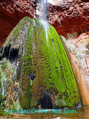
from BA to the Ribbon Falls turn off, and another half mile to the calcium carbonate cone coated
with dreadlocks of jade green moss, crystal water sparkling and coursing through the locks,
sliding sleek to stream level. Gorgeous.
I ease up behind the falls for some video and a portrait. The
Canyon shimmers through the falling water.
It's a delightful place for lunch and contemplation.
My feet bruise some on the return and I take a break before
helping Mike and Kathy round up empty banana boxes and plastic buckets and get them stored
in the waste water treatment shed or at the SAR cache for transporting tools back to IG.
A final Canyon shower and then dinner. I'm too tired, stuffed,
and busy with Becky's gift of a large stout beer to rally for a trip to the Phantom Cantina.
Day 9 Photos- VIPs at BA, 3-2018
|
|---|
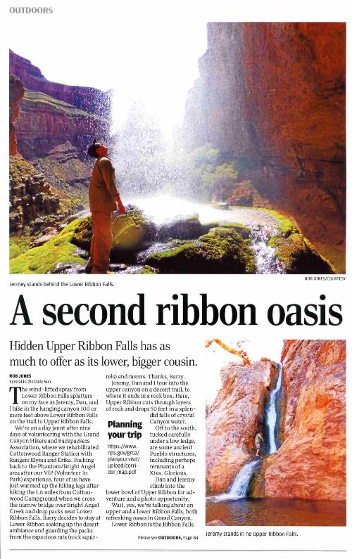
Bonus Feature: A Second Ribbon Oasis - AZ Daily Sun 3-30-2016, pdf
(Click the image to see the article)
|
|---|
|
|
|---|
Movie: video 2: Ribbon Falls, 71mb, Day 9
(Click the image to see the short video)
|
|---|
|
Day 10: IG Bound.
11 miles. ERM of 15. Up the South Kaibab, across the Tonto to IG, then out to Plateau Point.
No muffins greet the dawn; unimaginably, we're all maxed out on muffin mania.
Lazily packing, we remaining VIPs pass the newly painted rest
rooms and River Ranger Station, the rebuilt compactor shed, The Phantom Ranger Station fence, the
rebuilt valve house box, many assorted completed tasks on the way to cross The River. Paisley
emotions rule the morning, it's sad to leave, yet the trail beckons.
Up the South Kaibab, climbing above the jade green River, through
the basement rocks to and through the base of the Tapeats SandStone to the Tipoff and the scenic toilet
residing there. After a break, it's back across the Tonto to IG, pausing for lunch at Pipe Creek,
the tinkling burble of this miniscule flow provides an ambience rare to desert lore. At IG, a
hummingbird explores Kathy's red hat for nectar. The Red Buds are just beginning to bloom; and soon
IG will be resplendent in purple haze. Setting the TarpTent, Bill and I walk to Plateau Point to
watch the lenticular clouds form and listen to the River roll. Plateau Point is beach front property,
displaying the signs of waves in the (Tapeats) sandstone.
Approaching sunset, we remaining VIPs enjoy dinner with Ranger Betsy
on the new deck at the IG Ranger Station. We VIPs of the GCHBA replaced this deck during our last tour
de' Canyon. Veggie soup and a SouthWest Greek salad. Thanks Betsy!
Day 10 Photos- VIPs at BA, 3-2018
Day 11: Spit Out of The Canyon.
5 miles. ERM of 11. Up the BA to the BIC.
The first spitting raindrops dot the pack just after I
load in the tent. Good timing. Soon, I'm climbing out of The Canyon, looking out to a gray
day over the great abyss. Rain sputters yet I get wet from exertion and not really the rain.
The weather and the reported ice on the upper reaches of the BA Trail appear to have diminished
the crowds cascading down into The Canyon and it's reasonable to pick a way through the clumps
of Canyon gazers. Setting a steady pace, I'm nearly out of The Canyon by 10:30 a.m. when I
encounter the NPS Packers and mules on their way into The Canyon. We greet each other with
"thanks for what you do" and "see you again, my friend."
Day 11 Photos- VIPs at BA, 3-2018
"I measure your health by the number of shoes and hats and clothes
you have worn out." Ralph Waldo Emerson
"Under the desert sun, in the dogmatic clarity, the fables of theology
and the myths of classical philosophy dissolve like mist. The air is clean, the rock cuts
cruelly into flesh; shatter the rock and the odor of flint rises to your nostrils, bitter
and sharp. Whirlwinds dance across the salt flats, a pillar of dust by day; the thornbush
breaks into flame at night. What does it mean? It means nothing. It is as it is and has no
need for meaning. The desert lies beneath and soars beyond any possible human qualification.
Therefore, sublime."
Ed Abbey
*ERM: Energy Required Miles, are there data to support this
mileage adjustment?
Journal of Outdoor Recreation, Education and Leadership
Petzoldt first proposed his theory in his 1976 book “Teton Trails” to
help backpackers plan trips and calculate their energy needs on mountain trails. “Petzoldt defined one
energy mile as the energy required to walk one mile on the flat. He recommended adding two energy miles
for every 1,000 feet of elevation gain, so a person hiking one mile and 1,000 feet upward would use the
equivalent of three energy miles,” Phipps said.
Petzoldt’s energy mile theory was just a reflection of the mountaineer’s
“gut feeling,” Phipps said. The theory had never been tested in a laboratory before the study began in WCU’s
Exercise Physiology Laboratory in the spring of 2010, Phipps said.
To determine the validity of the theory, the study measured the energy cost
and perceived exertion for walking on flat ground, with and without a 44.5-pound backpack, and up an elevation
gain of 1,000 feet, with and without the backpack, through the collection of metabolic data, Phipps said.
Twenty-four student, faculty and staff volunteers, including 12 males and 12
females, went through four testing sessions as the research continued into fall semester of 2010. The study
results showed that the additional energy cost for ascending 1,000 feet ranged from 1.34 to 2.02 energy mile
equivalents, for an average of about 1.6 miles, compared to Petzoldt’s use of two energy miles for each 1,000
feet. The range revealed by the study was due to the “hikers” personal weight differences, Phipps said.
“It is remarkable that Petzoldt’s energy mile theory is so close to the actual energy cost measured during our
study,” Phipps said. “In the field of outdoor education, it’s important for leaders to include an estimation
of energy requirements during the planning of hiking trips.”
Phipps said the energy required for hiking up steep mountain trails would vary
for individuals and groups, and the variables of the trail would also factor in, but he recommends that
backpackers stick with Petzoldt’s idea of adding two energy miles for every 1,000 feet of elevation gain when
planning trips.
The Validity of Petzoldt's Energy Mile Theory, 2010
Authors: Maridy McNeff Troy, Maurice L. Phipps
Publication: Journal of Outdoor Recreation, Education, and Leadership
Links:

|
GCHBA Task List, Bright Angel CG/Phantom RS, 3-2018 (pdf)
(Click the image for the document)
|
|---|
Related Links:
Grand Canyon Hikers and Backpackers Association site (GCHBA)
GCHBA Service Projects Page
Magnificent Muffin Mania: GCHBA Volunteer Service Project At Bright Angel CG and
Indian Garden CG, 10-2017
Canyon Rover: GCHBA Volunteer Service Project At Phantom RS (Ranger Station) and Bright Angel CG, 3-2017
Finding Phantom: GCHBA Volunteer Service Project At Phantom RS (Ranger Station) and Bright Angel CG, 10-2016
VIP Cottonwood Rehabilitation Cruise:
GCHBA Volunteer Service Project At Cottonwood RS, 3-2016
Bonus Feature from the 3-2016 volunteer project: A Second Ribbon Oasis - AZ Daily Sun 3-30-2016, pdf
VIPs at IG - Volunteering at Indian Garden RS, 2015
GCHBA Gusher at BA - Volunteering at the bottom of The Canyon, 2015
Scenic Toilets of Inner Earth
the geology of the Grand Canyon by the NPS
Eaarth - Living on a fundamentally altered planet by Bill McKibben
Other WV reports about the Grand Canyon:
Click here or on the Looking Lizard to go to all WV reports about The Grand Canyon
|
|---|
Looking for All Wilderness Vagabond trip reports about the Grand Canyon?
Click the image to go to All WV reports about The Grand Canyon
|
|---|
|
More Truth Than Joke:

|
|---|
welfare is for the rich
(Click the image for the full-size image)
|
|---|
|

|
|---|
Intelligent Life?
(Click the image for the full-size image)
|
|---|
|
|
|---|
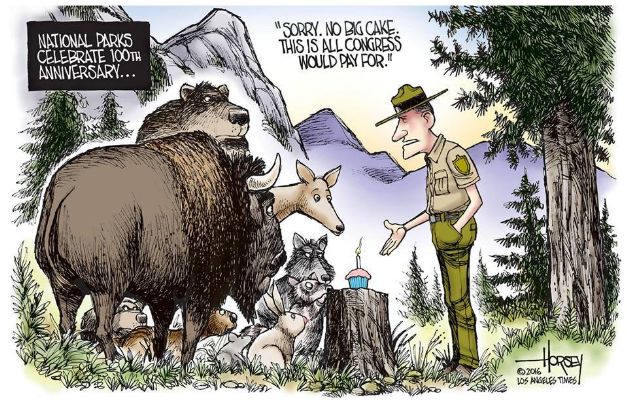
congress, fund the parks
(Click the image for the full-size image)
|
|---|
|


