(September 25th to October 3rd, 2021)
Text © copyright by Rob; and Photos © copyright by Rob Jones of the WV

|
Grand Canyon /
Escalantť Equinox Escapade: Grand Canyon /
Visiting: Tanner - Beamer - Escalantť Route - Nascent Tonto - Grandview
(September 25th to October 3rd, 2021) Text © copyright by Rob; and Photos © copyright by Rob Jones of the WV |
|
Co-Adventurers: Solo jaunt; assistance by Tim Wilson
Total miles = 58.7; ERM of 107 ERM = Energy Required Miles (see full description below).
camera: Panasonic DMC-ZS70
|
| |||||
|
| |||||
|
| |||||
|
| |||||
|
| |||||
|
| |||||
.
| ||||

![]()
| ||||
 |
 |
 |
 |
 |
 |
 |
 |
 |
| ||||
Day 1: Tanner Trajectory: To Tanner Rapids from Lipan Point:
8.3 miles, ERM of 20. Camp @ 2700'.
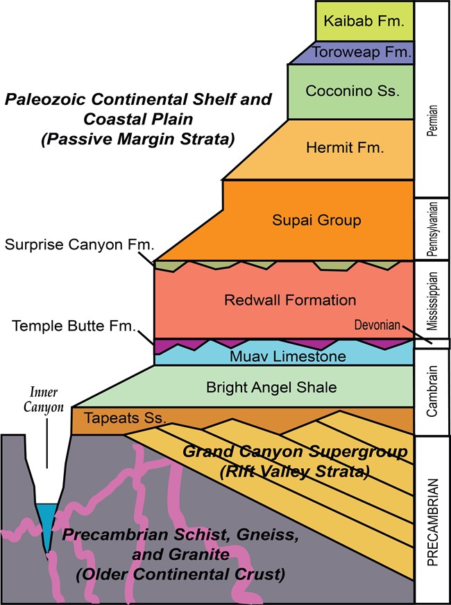
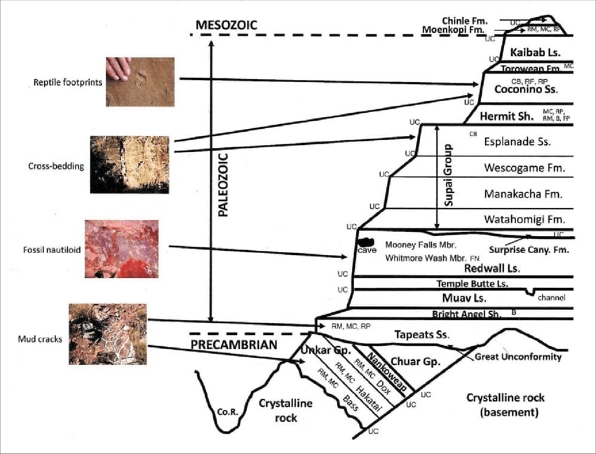
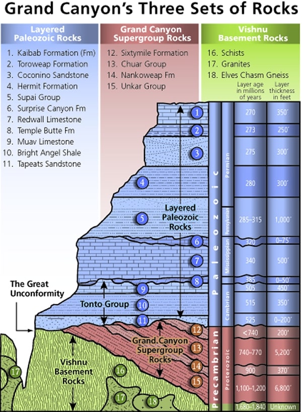
Mnemonic for the basic GC layers - Know The Canyons History, Study Rocks Made by Time
Know - Kaibab Limestone
Know The Canyon's History, Study Rocks Made By Time.
Tim Wilson and I are chatting and lounging in the shade of the Stegosaurus Rocks at the head
of Seventy-five Mile Canyon on the Tanner Trail, a place we'll loosely call Seventy-five Mile Saddle, under the watchful slope of
Escalantť Butte. Now in the Supai Formation, we've ball bearing hiked through the Kaibab and Toroweap Limestone layers and
the CoconiŮo Sandstone.
Tim heads back up the Tanner to work and I heft the bulky too-heavy bulbous pack and
continue toward the Colorado River, far below. "Well" I quip "the bulbous does contain 8 nights, 9 days of food and supporting fuel,
etc, so what do you expect?"
The day started at 5 a.m., (three days after the Fall Equinox) with a trip to the Park to meet up
with Tim at Grandview Point, a shuttle to Lipan Point, and plunging down the Tanner. Thanks for the shuttle and good discussions Tim.
Onward, with the next footbreak near the top of the Redwall descent, where the view is up
River to Temple and Chuar Buttes. Gorgeous.
Starting about 7500', I'm now around 5500', and The River is approximately 2700'. Of course,
the trail rolls, gathering and losing an additional thousand feet on the route to Tanner Rapids.
Below the Redwall and into the Muav Limestone for the next short break. I'm feeling fortunate
because thunderstorms are forecast for tomorrow, and the clouds seem to be gathering some today, providing sporadic and lovely shade.
Still, it's hot at times, probably about 90įF.
The trail continues sharply down, into the Dox of the Grand Canyon Supergroup. This grade
appears to be interrupted by the Shinumo? Then, more angled right grade to the foot in dry Tanner drainage, a short distance from
The River and the Tanner Scenic Toilet.
Gathering water, I see Ms. Blue (Heron) skulking in the tamarisk overhanging The River.
Time to retrieve the camera.
The clouds come and go, sunlight fades, intermittent color sweeps across the glassy water
upstream of Tanner Rapids. Canyon time.
I've used the apex guy lines to allow all four panels of the TarpTent Notch to be raised, yet
it's still quite warm.
When bats silently buzz me, I realize it's time to retrieve the headlamp and shuffle along to bed.
The noseeum bugs convince me that this is the right move.
I spend most of the evening nude on the pad until a brief rain rousts me to close the tent doors,
after which it's cool enough for part of the sleeping bag.
The - Toroweap Formation
Canyon's - Coconino SS
History - Hermit Shale
Study - Supai Group (including the Esplanade)
Rocks - Redwall Limestone
Made - Mauv Limestone
By - Bright Angel Shale
Time - Tapeats SS
Check the links section for lots more geology stuff. Here are versions of this basic schemata:
| ||||
| ||||
| ||||
| ||||
 |
 |
 |
 |
 |
 |
 |
 |
 |
 |
 |
 |
Day 2: Palisade Prowl; Beantown. To the base of the Beamer Trail: 4 miles, ERM of 6. Camp @ 2760'.
Lounging at second breakfast in the deep shade of an Espejů Creek cutback, the silence is the way it should be, natural
and complete. I can hear flies buzzing across the dry streambed. Downstream an unseen Raven chortles. This, natural quiet, is The reason
for the Park. Not the intrusive clatter of air tour terrorist overflights, which represent corporate welfare, plutocracy, climate change, and the
marbled obese fattening of America. No, this is not stuff of the Park charter. Horrendous. Yes, it's corporate welfare, where we literally pay
profiteers to steal a rare and precious public resource and privatize the gain while socializing the loss.
There are much better alternatives for the callous rich, out of shape (assuming they were ever in
shape) and infirm and just plain lazy, one example being the well graded and informative vistas from the Trail of Time along the South Rim.
And, surprise, it's in the no fly zone, so quiet. All air tour terrorist activities should be only over the corridor, much like a utility easement.
This way, corridor users can enjoy the air tourists, and use is concentrated so that the vast majority of the wild portions of the Park are
preserved properly. And using the Trail of Time is not a climate buster like wasteful aviation. One of the very few positive outcomes of the
MAGAvirus and associated freedumb vaccine refusers might be the highly anticipated bankruptcy of the harmful and wasteful and
unnecessary air tour terrorists. Get out of your tourist tin can and walk, crawl, bike, use a wheelchair or walker and absorb the incredible
vistas, the natural quiet, the information of the Trail of Time. Please. Do it for the Eaarth.
This morning, I again encounter Ms. Blue, this time standing watch over The River from the Dox cliffs
as I edge around to where this high route drops back to near River level in the unnamed drainage South of Comanche Creek.
When I get to the lower level, I see a Raven fly into a dead tree carrying something. The something,
as best I can tell, is a hapless lizard, which the Raven tears into bits and enjoys as breakfast. I try for a short video.
It's a great day to hike, given the overcast sky, but a poor day for charging up via my Lightsaver
solar panel. It's more humid too.
I wander to the Palisades abandoned mine area and prowl about. I find some pottery sherds, a
rats' nest of cable, and the remains of what I suspect is the cabin associated with the mine. The mine entrance is gated to protect bats. The
only other stuff I find from the mining days are clumps of broken dishes and bottles.
On to camp. Entering the protected nook where tamarisk border mesquite, I duck in to see a
curlicue of mesquite beans artfully littering the ground. Beantown. Natural art. This is at approximately River Mile 66.
Late second lunch is a tortilla layered with tuna, mayonnaise, bacon/ghee from a Breast milk
container, and salty potato chips. Yummy. Yes, one of the terrific things I learned preparing to hike the JMT (John Muir Trail) this year
was the use of Breast milk containers to store olive oil, ghee, nut butter, you know, those calorie dense foods that have lots of fat, which
is good for controlling pack weight and also for keeping one warm through the night. Terrific. I prefer the Kiinde 6 ounce twist-top
model. I have not had them leak, even when toting olive oil through the Sierra or The Canyon. They are tough and about 3 or 4
of them weight an ounce. Pragmatic. (See one use of Breast milk containers after Day 9.)
 |
 |
 |
 |
 |
 |
 |
 |
 |
 |
 |
 |
 |
 |
 |
Day 3: A Bodacious Beamer Beating; Astounding Azure.
To the LCR, Little Colorado River, and back:
13.1 miles, ERM of 21.
Bats swirl just off the ground in the fading crepuscular, as if flying a roundabout.
Around and around me and the center mesquite they circle, artfully dodging each other and the numerous obstacles.
I must serve as an insect magnet, I muse. I sit still and enjoy the show with a big grin on my face.
Early wind prompts me to reconsider camping downstream from the LCR/River
confluence. Since I'm up fairly early, I'll switch to a long day hike.
And the wind does buffet me as I carefully walk the narrow ledges for which the
Beamer is famous. One and done ledges. One extra step and you're done, off into the abyss and a few hundred feet of
thrill before you hit the River. Or an inconvenient rock. An unpleasant outcome.
The dark clouds make a mess of the early photography. As the storm pulse heads
West, clouds are replaced by brain-baking sun. Clouds peel over the rim, curling around the rim and drifting downward over
to the South, perhaps near CardeŮas? There's a short opportunity to capture some of the River/Chuar Butte grandeur, and
much of the morning glow is missing from the River, yet it's what's offered. Spectacular. One is mindful of terrain and the
one and done while gazing at the sheer immensity of The Canyon.
The LCR, yowee, is resplendent in indescribable blue. Astounding azure, is what
I termed it the last time I was here. An inadequate description, yet okay.
Photos fail to capture the silky cerulean blue of the LCR. Turning up the LCR, I
continue to the Beamer Cabin, which apparently is a reworked Native structure. The placement is fine, and still in the shade.
Probably, it's always in the shade this time of year. After a deserved break, I start back to camp at Beantown. But first, I
drop to the River at the only access between the LCR and near Palisades Creek to treat two liters of water and eat the main
lunch, second lunch. The heat increases along with the solar load, and, its umbrella time.
A yellow-footed Collared Lizard jumps onto a rock alongside the trail, reminding
me to look closer for Canyon splendor. We eye each other, and one of my eyes is a camera lens.
Increasing my foot breaks as the shade lengthens in the side canyons, and my
septuagenarian grit fades, I arrive back to Beantown just prior to dark. The River water has warmed in the bucket
I hung this morning in the mesquite, just right for a bucket bath.
The Canyon electric company puts on a silent strobe light show far up Lava Canyon,
perhaps even the North Rim, yet only intermittent swirls of cool air reach Beantown.
Tamarisk, (Tamarix spp.) commonly known as salt cedar: is an exotic (non-native)
shrub or tree that grows in dense stands along rivers and streams in the West. Tamarisk, introduced to the U.S. in the 19th century
as an erosion control agent, spread through the West and caused major changes to natural environments. Tamarisk reached the
Grand Canyon area during the late 1920s and early 1930s, becoming a dominant riparian zone species along the Colorado River
in 1963 (following completion of Glen Canyon Dam).
The impacts caused by tamarisk in the Southwest are well documented. These prolific
non-native shrubs displace native vegetation and animals, alter soil salinity, and increase fire frequency. Salt cedar is an
aggressive competitor, often developing monoculture stands and lowering water tables, which can negatively affect wildlife
and native vegetative communities. In many areas, it occupies previously open spaces and is adapted to a wide range of
environmental conditions. Once established in an area, it typically spreads and persists. (from the NPS Grand Canyon page)
Grand Canyon Panorama Project - by Larry Wieland, Little Colorado. You can see the area I hiked by visiting this site. There are many options - click on the spheres to go to a panorama from that point. There are several panoramas taken from the Beamer Trail, for instance. Options also include: Add geology or topo map. A super series of panos and supporting geology maps. Start with the below link, use the geology map, move around to another pano. Superb. Grand Canyon Panorama Project - Little Colorado River Panorama (link here).
| ||||
 |
 |
 |
Day 4: Local Exploration. Palisades Creek:
@ 4 miles, ERM of 6.
Sitting back against a supportive mesquite tree, I'm watching the first blush
of pink caress the South flank of Temple Butte, just peeking above the tamarisk that provide a break from the vigorous
upcanyon morning wind. Canyon time is slowly savored as I await the couscous, raisins, protein powder, nido, milk
powder, and sugar breakfast to hot soak into its full goodness. Ahh. Accompanied by hot chocolate, it's basic Canyon
cuisine. A healthy breeze shoots through Beantown, so I know it's screaming out in the open.
Sunlight leaks into Beantown and I surmise that it's time for exploration. I've
earned a day of exploration by yesterday day hiking to the LCR rather than trundle there and back and camping near the
LCR. It's another quiet day. I've seen no other hikers since dropping below the Redwall on Day 1. Sure, I've seen boaters,
and only from a distance. Hurrah.
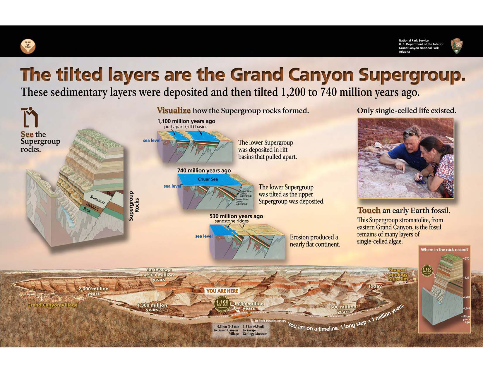
Palisades Creek seems to be part of the Grand Canyon Supergroup because it's a
mishmash of familiar and unknown layer cake strata and tilted layers. I contemplate how little I'm certain about as I lounge
on what appears to be Bright Angel Shale. Shinumo and a bulky basalt intrusion are also evident. I'd like some guidance
from Geology Tim about now.
It's a surround sound of natural quiet, except when this quiet is shattered by the
invasive aversive air tour terrorists overflighting in high-decibel aluminum tubes.
It's a day of schizophrenic weather. The wind blasts along the River, upcanyon,
then calms before gusting downcanyon, sounding like a freight train as it arrives. Clouds obscure the sun, cooling the Eaarth,
flipping to roasting mode under full sun. I'm napping in the shade on this shale slickrock bench awaiting the arrival of the
Bighorn Sheep I've been following when a sock flies past, wrapping around my nose. No Sheep, just vagrant socks. It's a sign
that it's time to return to Beantown to cleanup and cook, and perhaps lounge a bit more.
Diabase Sill: An intrusion of igneous rock into existing rock which spreads along bedding planes in a nearly horizontal sheet.
 |
 |
 |
 |
 |
 |
Day 5: CardeŮas Caper. To CardeŮas drainage:
7.5 miles, ERM of 11.
The day starts cloudy and goes on to include some rain. Just enough to employ the umbrella.
A fine day for walking yet I'm unable to get any charge on the panel today,
so these notes will be truncated.
As I'm just getting the moving parts up to turtle speed, I encounter Mike, the
first hiker since part way through Day 1. A long chat about the LCR and Canyon stuff ensues.
On to the benches before Tanner, where the wind tries to fly my hat into the
River. Fortunately, I've anchored it to my pack, so it stays another day.
In a well-protected nook next to the River at Tanner, I encounter Larry of Kentucky.
A long discussion and lunch is enjoyed before continuing to CardeŮas. There's a rafting group that's just pulled into
CardeŮas, a not particularly hospitable commercial group, so sharing is no fun, no fun at all. The guide tells me to get
lost in every way except saying it. "We are a group that likes our space, we are taking over the beach, we are wondering
how you might access any water here," etc. Gee, what BS. I search and find a decent site, one that's too close to the
CardeŮas drainage given current conditions, yet it will do. The next section of the Escalantť Route is far from the River
and other water, so this is it.
Fortunately the day closes with a sunset glow over downriver buttes, followed
by the first clear night sky of the trip. The air cools rapidly, the Milky Way bisects the night sky, and it's actually cool
enough to use the sleeping bag. And appetite and hunger abound. Wow. A goodnight from a pleasantly cooling CardeŮas camp.
 |
 |
 |
 |
 |
 |
 |
 |
 |
Day 6: 75 Split Pea Chocolate Thunder. To Seventy-five Mile Canyon. You Otter stay for dinner:
7 miles, ERM of 11
I'm lounging in the precious deep shade of the wall at the mouth of Escalantť Canyon
watching and listening to the chocolate thunder of the River, which is about 200 feet distant. Yes, chocolate thunder.
The day starts with the uphill on the fault plain above Unkar Rapids. First stop is
Hilltop Ruin, an apparent signaling location because one can see this location from other important places. It's nowhere
near water but the vista is spectacular. It's a day of transition from mostly cloud cover to mostly sunny.
The buttes and slopes are well dappled by cloud shadows.
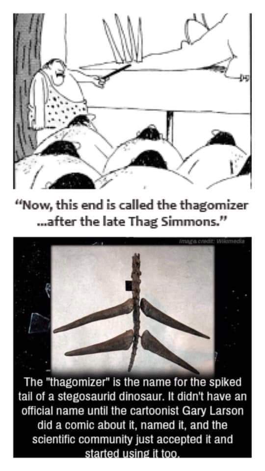
Continuing on the up-scarp, I gaze at the Thagomizer Ridge bristling above. The
name Thagomizer comes from a Gary Larson cartoon describing a Stegosaurus tail as a "Thagomizer." Thag being a hapless
Neanderthal who too close approached a Thagomizer. This name has been officially adopted by scientists. Really, look it up.
I'm wondering how far up this slope the trail climbs below Thagomizer Ridge. It's a tedious process.
Of course, Neanderthal and Dinos did not overlap, something repulsican VP candidates
(e.g., Palin) don't understand. Yet, anything is fair game in a Gary Larson cartoon.
Then, looking back at the Unkar area, I notice that the River is now split pea soup green.
Oh oh, oh no. It must have rained hard somewhere in the vast LCR drainage. Either that or in the Paria River drainage. Yikes.
Now I'm appreciative of taking the time to locate my tiny satchel of alum and add it to my water kit.
It's tedious getting around, through the boulder clutter and the boot-width Escalantť
Route and into the Escalantť Drainage. And incredibly noisy at times from the air tour terrorists.
Now, at the mouth of Escalantť Creek, the River hue has deepened to chocolate fudge
as it thunders through the unnamed rapids.
As the Shinumo Quartzite is rising slanted from the River, I'm climbing it to then hike
along the rim of Seventy-five Mile Canyon to the quartzite slide/steps leading into the canyon proper. And what a gorgeous canyon
it is. Polished quartzite walls inlaid with artistic swirls and designs.
Crunching down canyon, I soon see a member of the Otter river rafting group, also
exploring the canyon.
Rounding the wall near the River, I encounter a whole group of Otters, who after some
discussion, graciously invite me to join them in the nook. Fabulous, and more.
A loss of gross motor skills soon follows as the Otters ply me with beer. The effect is
heightened by dehydration. Silly, yet I have reduced water guzzling after seeing the mucky murk of chocolate thunder. Then
dinner accompanied by a costume party, where the young women decide I should be "No shit, Sherlock," complete with funny
hat and "No shit" emblem on a vest. Excellent fun with wonderful people displaying superb hospitality. Dinner is chicken with
rice, yams, edamame, and Dutch oven pineapple upside cake. Fabulous. The range of discussion topics is phenomenal, from
classic blacksmithing to preventing antisocial behavior in school-aged kids to touring The Canyon. Thanks for your hospitality,
Otters.
The group switches to playing music, and I enjoy the superlative natural quiet of Neville
Rapids while inspecting my eyelids.
 |
 |
 |
 |
 |
 |
 |
 |
 |
 |
 |
 |
 |
 |
 |
Day 7: Papago Pursuit. To Red Canyon/Hance Rapids:
1.5 miles, ERM of 2.
I've just said my goodbyes to the delightful Otter group and popped out
into the sun from the 75-mile nook when I see Larry starting the trek along the sidehill to the base of the Papago
Wall (followed by the Papago Slide), then the rock hop and brush beater to Red Canyon/Hance Rapids. I'm leaving
the Otter group with full belly (French toast), and clean water, and good spirit bolstered by good people.
Larry and I trundle along the sidehill before enjoying a French toast and pineapple
upside down cake goo snack in the slot of Papago, below and gazing at the Papago Wall. The French toast, of course, courtesy
of the Otter rafting group. Thanks Kevin, Jemima, et al.
I see a way up the wall, finding it to represent what Lon A., formerly of the BIC, described
as the "perception of danger." Gretchen and Adrian come along and fluidly scale the Wall.
Then over the small bump to the top of the Papago Slide, a precarious pile of large
sugar cube talus luring hikers to glide the Slide, leaving behind their precious skin. It's a slow and solo (one hiker at a time) descent.
Now, approaching 6 p.m., I'm lounging in camp not far from Hance Rapids and enjoying
the view of a diagonal diabase sil knifing through what I'm guessing is Hermit Shale, awaiting dinner cooling, and the alum
finishing its magic with the mud water. It's cleared enough for cooking, yet I'm hoping for more clarity in producing drinking
water for tomorrow's hike. A full laundry is drying on a friendly mesquite.
Clarifying muddy River water - link here
The temperature is just right for shorts and sandals, which is a good thing because I
River washed everything else as soon as finding a camp.
As the post Equinox sunset fades into dusk, I revisit a short mileage day well hiked.
| ||||
 |
 |
 |
 |
 |
 |
Day 8: Hakatai Hance Hump. To Hance Creek. Nascent Tonto Trail:
7.5 miles, ERM of 18. Camp @ 3700'.
It's already trending toward hot as I weave through the Tapeats boulders and
round the corner onto the Hakatai hump grade. Today starts the Tonto Trail as one hikes West from Red Canyon.
Nascent. The trail in the Hakatai Shale chugs up the angle of repose before sliding into Mineral Canyon. Time for
second breakfast and a footnote to Vishnu Temple. The alum-settled water is very tasty indeed, especially considering
the chocolate sludge from which it came.
From Mineral Canyon the trail climbs up to the Tapeats Sandstone and enters
the layer cake strata of The Canyon, representing horizontal formations. The Tonto begins its Tontour on the contour.
From here, one lilts along the Tapeats to Hance Creek, a lovely tour indeed.
Pausing in some shady ledges, and it's first lunch.
I join Brandon in the deep shade slickrock bench at Hance Creek. We lounge
through second lunch and talk about Canyon stuff. There's also discussion about how to keep one's personal inflation
rate low. Perhaps the most salient factor is not having children. Either that or "Maybe One" which is also the title of a
book by Bill McKibben. Of course, none is the only environmentally valid option in these days of spiraling global heating,
desertification of the Eaarth, species annihilation, and increasing hoards of climate migrants. He who has little house is
little owned. Not having any loans, etc. make for a low personal inflation rate. Adrian and Gretchen come into the Hance
riparian area and gather water for a night on Horseshoe Mesa. Lots to lug, Brandon and I note. Local sunset has arrived,
quickly engulfing the Hance basin. Time to set camp, gather more water, enjoy a bucket bath and dinner.
This is the first and only camp of the current adventure without background River
music. Instead, it's fabulous quiet now that the air tour terrorists have returned to base to count the value stolen from the public.
A few, apparently confused or second family Canyon Tree Froggies chortle listlessly
in Hance Creek as natural quiet deepens gloriously. There are young tadpoles in the creek and I implore them to hurry,
cold weather is on the way.
 |
 |
 |
 |
 |
 |
 |
 |
 |
Day 9: Where's the Trail? To Grandview Point:
5.2 miles, ERM of 12.
.
Billions and billions of stars grace the sky as an owl begins his pre-morning
hootage. Crepuscular calling. I'm up with the stars to get an early start on today. The owl knows best, because very
quickly it's crepuscular creep, with dawn quickly following, "hoot, hoot-hoot," repeat.
I see that Brandon is ready to go, and we briefly hike the Tonto Trail before
starting the climb up the East side trail to Horseshoe Mesa. This is the trail that passes Miner/Page Spring. It's not
my favorite trail, and Brandon and I talk briefly about circling the Mesa and going up the Center (historic) trail. Some
Tontouring is always fun. Yet this adds more than 3 miles to the quest to reach the Mesa.
The bottom part of the East side trail is OK, luring hikers up into a rockpile
that has replaced the trail. The trail was steep, now it's 70% gone, used as a stream path for one of the recent
thunderstorms that damaged several Park trails.
It's a grunt. Easy to get off the route, it results in floundering over the steep
erosion talus. Ick.
After a long foot and snack break in the shade of the old miner cookhouse
walls and a visit to the Mesa scenic toilet, we start through the Supai Formation toward the rim. This scenic toilet
provides excellent views of Vishnu Temple and several buttes of the Zoroaster collection. The Supai Formation trail
has experienced numerous washouts, yet nothing like the mess of the East Mesa route. It's more annoying than
dangerous or confusing.
Nearing the CoconiŮo Sandstone, the trail is less impacted. Yet decidedly
more up. And up.
Amazingly, when I reach the top I see Brandon, Adrian, and Gretchen
replenishing electrolytes by eating salty snacks, while telling tales of The Canyon. I join them and we discuss the
joys of an Escalantť Equinox Escapade.
*ERM: Energy Required Miles, are there data to support this
mileage adjustment?
Journal of Outdoor Recreation, Education and Leadership
Petzoldt first proposed his theory in his 1976 book ďTeton TrailsĒ to
help backpackers plan trips and calculate their energy needs on mountain trails. ďPetzoldt defined one
energy mile as the energy required to walk one mile on the flat. He recommended adding two energy miles
for every 1,000 feet of elevation gain, so a person hiking one mile and 1,000 feet upward would use the
equivalent of three energy miles,Ē Phipps said.
Petzoldtís energy mile theory was just a reflection of the mountaineerís
ďgut feeling,Ē Phipps said. The theory had never been tested in a laboratory before the study began in WCUís
Exercise Physiology Laboratory in the spring of 2010, Phipps said.
To determine the validity of the theory, the study measured the energy cost
and perceived exertion for walking on flat ground, with and without a 44.5-pound backpack, and up an elevation
gain of 1,000 feet, with and without the backpack, through the collection of metabolic data, Phipps said.
Twenty-four student, faculty and staff volunteers, including 12 males and 12
females, went through four testing sessions as the research continued into fall semester of 2010. The study
results showed that the additional energy cost for ascending 1,000 feet ranged from 1.34 to 2.02 energy mile
equivalents, for an average of about 1.6 miles, compared to Petzoldtís use of two energy miles for each 1,000
feet. The range revealed by the study was due to the ďhikersĒ personal weight differences, Phipps said.
ďIt is remarkable that Petzoldtís energy mile theory is so close to the actual energy cost measured during our
study,Ē Phipps said. ďIn the field of outdoor education, itís important for leaders to include an estimation
of energy requirements during the planning of hiking trips.Ē
Phipps said the energy required for hiking up steep mountain trails would vary
for individuals and groups, and the variables of the trail would also factor in, but he recommends that
backpackers stick with Petzoldtís idea of adding two energy miles for every 1,000 feet of elevation gain when
planning trips.
The Validity of Petzoldt's Energy Mile Theory, 2010
Authors: Maridy McNeff Troy, Maurice L. Phipps
Publication: Journal of Outdoor Recreation, Education, and Leadership
.
 |
 |
 |
| ||||
Links:
Map of the route hiked.
This web version from GPS Visualizer can be enlarged
Link to all WV trip reports about The Canyon (WV)
Panorama Project: Escalante Route
the geology of the Grand Canyon by Canyon Dave
the geology of the Grand Canyon by the NPS
Falter - Has the Human Game Begun to Play Itself Out on this Eaarth? by Bill McKibben
Other WV reports about the Grand Canyon:
Click here or on the Looking Lizard to go to all WV reports about The Grand Canyon
| ||||
More Truth Than Joke:
| ||||
| ||||
| ||||
| ||||
| ||||
| ||||
| ||||
| ||||
| ||||
|
Wild Vagabond Main |
Trip Report Index  |
Caveat  |
|---|