Astounding Azure:
Grand Canyon Trip Report - Tanner Trail / Beamer to LCR (Little Colorado River, an improbable blue)
/ 75-mile / Papago Slide and Wall! /
Red Canyon / New Hance Trail
(April 20 - 26, 2015)
Text
© copyright by Rob; and Photos and sound © copyright by Rob Jones
|
 |
Co-Adventurers: Jeremy Wright, Dave Rumbellow, & Rob
Click here
to see the report about the first exploration of part of this section. The Escalante Escalade!
Click here
to see the report about the second exploration of part of this section. The Evocative Escalante!

|
|---|
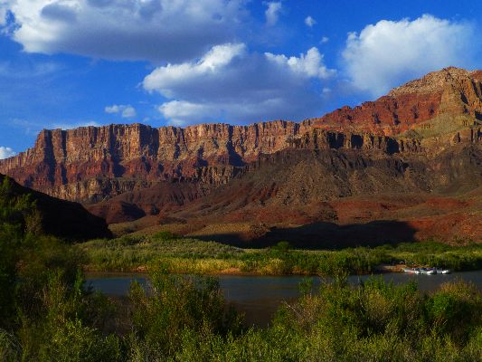
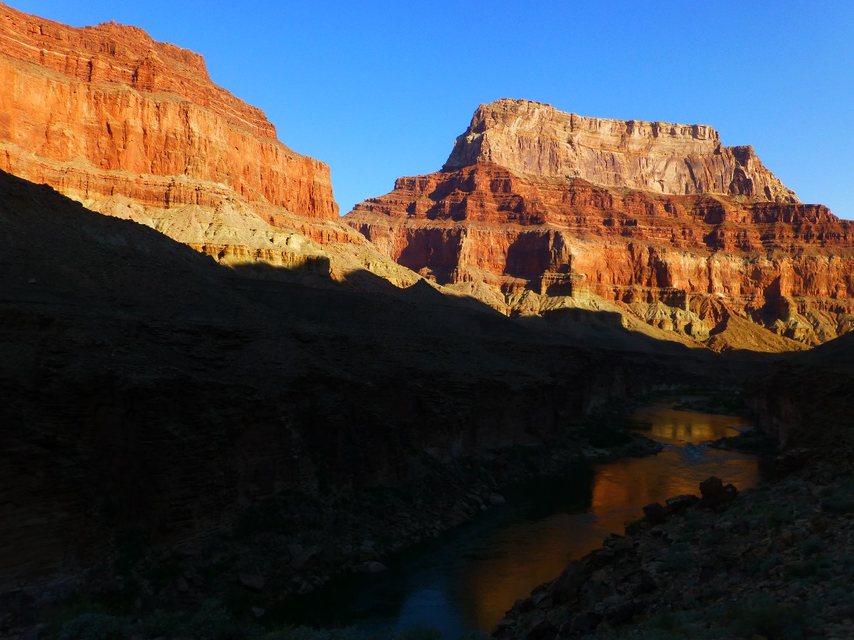
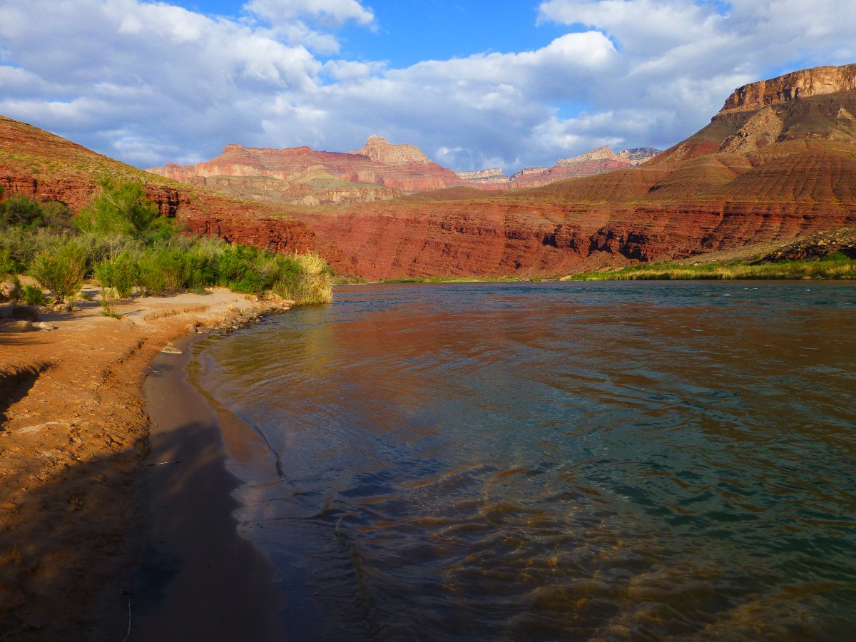
Tanner Beach, Day 1
(Click the image for the full-size image)
|
|---|
|

|
|---|
Starting on the Beamer, Day 2
(Click the image for the full-size image)
|
|---|
|

|
|---|
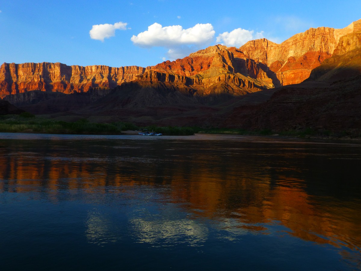
Early morning on the Beamer, Day 3
(Click the image for the full-size image)
|
|---|
|

|
|---|
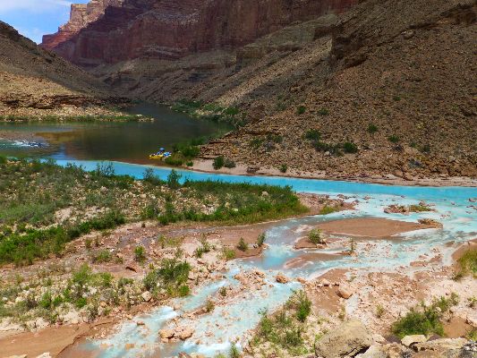
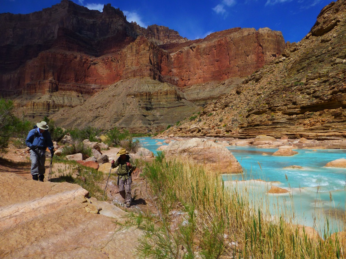
Astounding Azure of the LCR, Day 3
(Click the image for the full-size image)
|
|---|
|

|
|---|
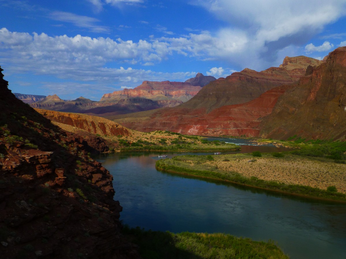
Cardenas Beach, Day 4
(Click the image for the full-size image)
|
|---|
|
|
|---|
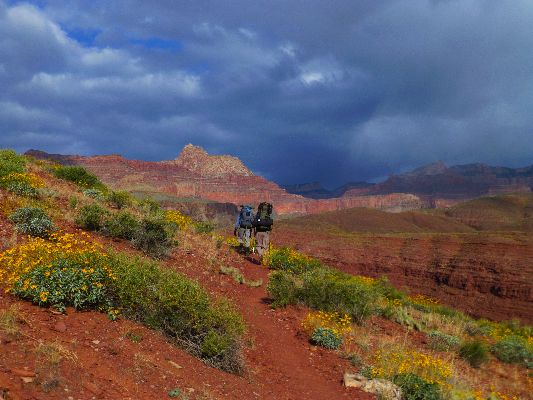
On the Escalante Route, Day 5
(Click the image for the full-size image)
|
|---|
|

|
|---|
pano from Lipan Point (Tanner TH) - scroll L-R to view it all (3356 pixels wide)
(Click the image for the full-size image)
|
|---|
|
|
|---|
movie 2 - Along the Beamer, Day 3; 10.5mb
(Click the image to view the movie)
|
|---|
|
Astounding =
causing astonishment or amazement
Click here to: Hear the committee in support of natural quiet in the GC. (MP3 file; 192kb)
Click here to see the destruction
of natural quiet over the Grand Canyon - Natural Quiet or Noise Park? (youtube video - 4.5 min.)
Click here to see Alum Water
treatment for GC hikers (pdf by John Ladd)
The greatest challenge we face in America today is to stop the buying and selling
of our poltiicians and political process by corporations and the rich.
- Bill Moyers
I want to ask you to do one thing in connection with it, in your own interest
and in the interest of the country — keep this great wonder of nature as it now is,
I hope you will not have a building of any kind, not a summer cottage, a hotel, or
anything else, to mar the wonderful grandeur, the sublimity, the great loneliness and beauty
of the canyon. Leave it as it is. You cannot improve on it. The ages have been at work on
it, and man can only mar it.
- Teddy Roosevelt, 1903
Total miles hiked = 48.8. Total ERM = 89.
ERM = Energy Required Miles. A mile is added for every 500' elevation gain or loss.
It's a very serviceable method of estimating energy required miles.
Camera = Panasonic DMC-ZS19


|
|---|
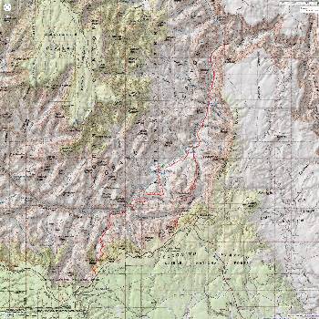
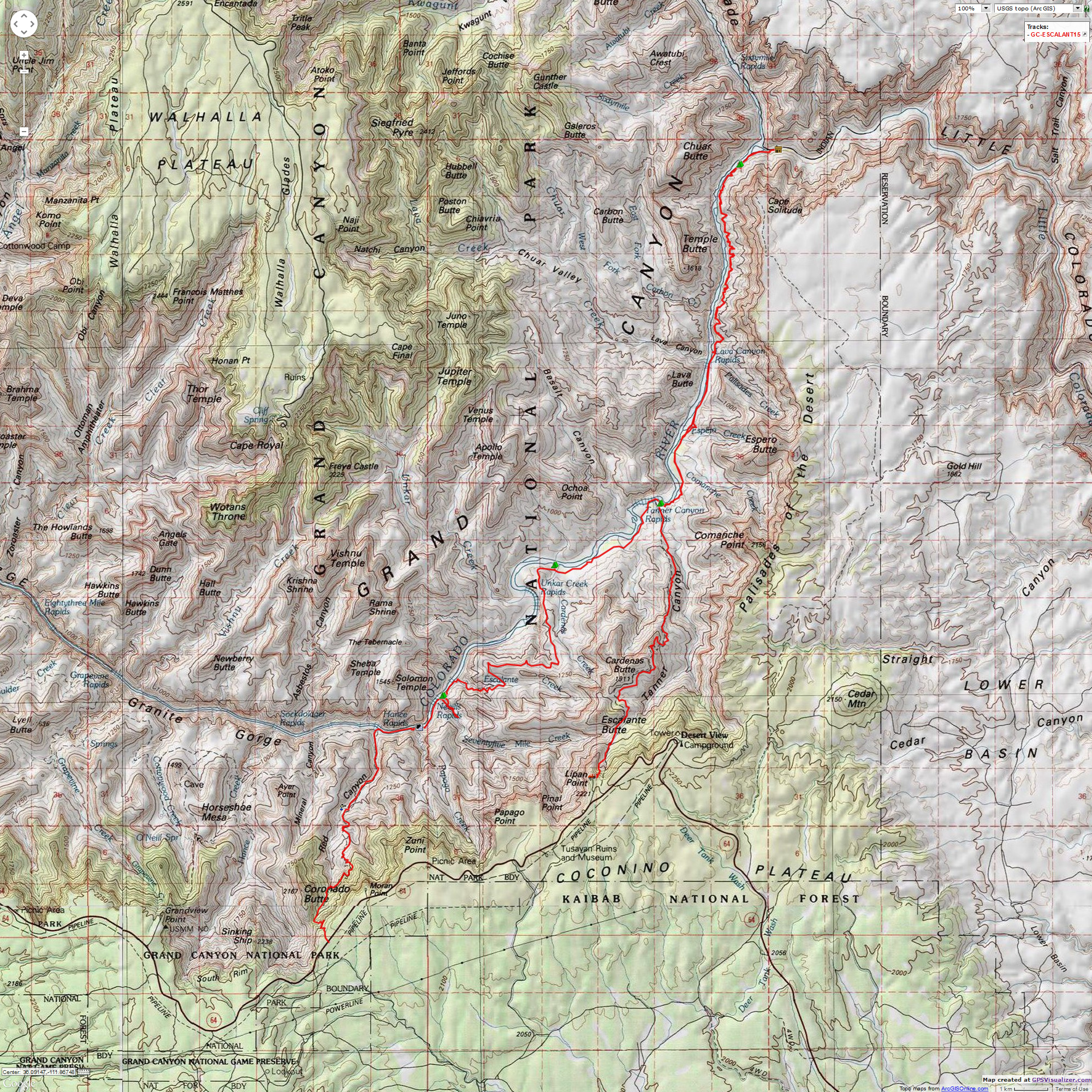
Map - GC: Tanner - Beamer - Escalante - Red Canyon -New Hance; 2015; 49 miles
(Click the image to see the map)
|
|---|
|
for a full-resolution map, click here. Caution - do not use this map or gps track for
navigating the route.
Right
Click (then save this file: "save link as..." in most browsers) on this Download link to get the GPX file from
my GPS - you can then open it in your mapping software. Note - that's a Right Click on this link.
You will get the track for your software shown in the map above.
Day 1. Trounced by Tanner - To Tanner Beach.
8.1 miles, ERM = 20.
I'm watching the kodachrome of Canyon colors as they morph from red
to pink, gold to yellow along the Palisade of the Desert. My view includes the eddies of the Colorado
above Tanner Rapids. Ahh. Jeremy, Dave, and I are finally in camp after a trouncing by the Tanner Trail.
The day starts with a shuttle to Lipan Pt by Tim Wilson. Then the dramatic
drop through the Kaibab, Toroweap, and Coconino, more stepping down than hiking. Some actual hiking and a
few shade stops brings us to the rolly rocks Redwall plunge. From here, the trail mostly contours, wrapping
feet against the side of boots with the side angle to the tread. More down, into the Dox Sandstone.
Approaching the scenic toilet of Tanner.
Jeremy produces a GC Margarita that lubricates the Canyon aches.
A bucket of River water frigidly removes the salt and grime.
Day 1 photos from Astounding Azure
|
|---|
movie 1 - Tanner Beach, Day 1; 9.5mb
(Click the image to view the movie)
|
|---|
|
Day 2. Pleasing Palisade - to Palisade. 4.0 miles. ERM = 6.0.
Andrea of the NPS rolls along the trail, greeting us as we approach
the foot of the Beamer Trail. It's been a fine day of shuffling along the Palisade area, on the benches
and alongside the River. Clouds roll in and out, and I employ the shiny umbrella when the sun glares.
We locate a fine camp sheltered by Mesquite and Tamarisk and lounge away
the afternoon with River baths, laundry, journal writing and gazing at rocks made by time.
A delightful day but for the flying turd fondlers, the air tour terrorists.
Noise, unnatural noise, abrasive, intrusive, money-driven noise that is an anathema to the Park charter,
which lists natural quiet as a precious resource. This resource was sold to corporate welfare artists by
McCain, once a maverick for public land (hah!). As is usual, the corporation gets the profit, the public
gets to pay for it via loss of a public resource.
The air tour terrorists and other corporate welfare power people are in
great contrast to what Abbey says. “Yes, there are plenty of heroes and heroines everywhere you look. They
are not famous people. They are generally obscure and modest people doing useful work, keeping their families
together and taking an active part in the health of their communities, opposing what is evil (in one way
or another) and defending what is good. Heroes do not want power over others.” - Edward Abbey
The words of John L. Stoddard highlight how much the character of the Grand Canyon has been lost since the
description of his visit to the Park was published in 1904:
"Many grand objects in the world are heralded by sound: the solemn music of Niagara, the roar of the active
geysers in Yellowstone, the intermittent thunder of the sea upon a rocky coast, are all distinguishable at some
distance; but over the Grand Canyon of the Colorado broods a solemn silence. No warning voice proclaims its
close proximity."
For our generation, the Grand Canyon is now heralded by the intrusive sound of aircraft.
Day 2 photos from Astounding Azure
Day 3. Beamer Bounce, an Improbable Blue - 13.1 miles. ERM = 21. Day hike.
Silky azure blue, the LCR (Little Colorado River) blue springs water rolls
into the jade River, melding with the Colorado jade and disappearing. We've made it to the LCR, mostly
hiking in the shade of the big walls of the Palisades of the Desert. Now, as we approach Beamer cabin,
it's getting hot.
The LCR is an astounding azure. Even that fails
to describe the hue of
the LCR. Is it cornflower blue? Iceberg blue? Bleu de France? Cerulean blue?
All fail the quest to
describe the improbable blue of the LCR. Then, there is the feel, the texture, of the mineral-laden water.
Silky, velvety, silken, satiny. Imagine your favorite girlfriend - it's more silky than that.
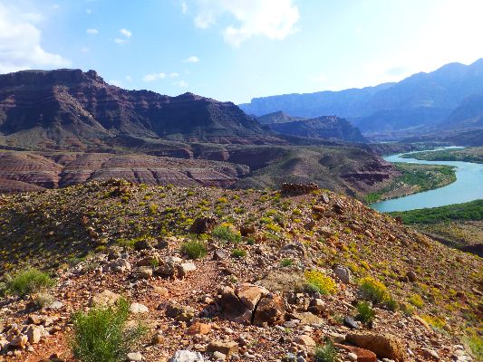
Along the Beamer, the views across the gold -flaked River to Chuar Butte
are magical.
Walking the narrow edge of the Beamer, far above the River, presents an
eerie void of Canyon. On the River side of the trail, it's one and done, one step off the trail and you're
done, 300 feet of air to the crispy Colorado waters. Not a place for the inattentive.
Jeremy floats in the mineral-laden waters, and soon it's time to start the
slog back to camp.
We stop at the camp area just downstream of the confluence, which affords
the only access to the River before dropping off the Beamer nearly 6 miles distant. A place to replenish
the water bottles, enjoy the last hat and shirt dip of the day.
The umbrella works well for the first several miles, then the breeze becomes
too much and it is stowed.
We ease into camp in time for a bucket bath and clothing rinse before
cooking dinner in the dark.
Tired puppies.
My big toe is throbbing from being pierced by a Canyon caltrop this
morning, while out searching for a scenic toilet in the dark.
|
|
|---|
movie 3 - Beamer blooming colors, Day 3; 13 mb
(Click the image to view the movie)
|
|---|
|
Day 3 photos from Astounding Azure
|
|---|
movie 4 - Astounding Azure, Day 3; 15.5 mb
(Click the image to view the movie)
|
|---|
|
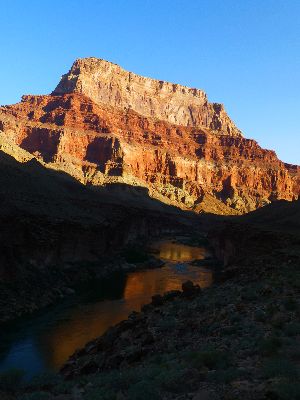
Day 4. Cardenas Cruise - to Cardenas Creek. 6.9 miles. ERM = 11.
The Tanner Rapids water leaps and jostles, cooling the nearby air like
a Phoenix evaporative cooler (yet so much better and more sustainable). Phoenix, another of those legions
of cities that should not exist (not sustainable, no water, etc., like Las Vegas, Los Angeles...). We've
retraced our route to Tanner from Palisades, and we're enjoying lunch in the cool aura alongside the rapids.
Then it's on the beach and bench route to Cardenas, where we're happy
to find no rafters. Along the way, we can see on the skyline the faint outline of the Hilltop Ruin,
noting its careful placement to survey the land.
I'm still feeling enervated, presumably because of yesterday's good
beating, and feel fine not sharing Cardenas camp.
Day 4 photos from Astounding Azure
Day 5. Slithering Shinumo Shuffle- to 75-mile. 7.7 miles. ERM = 11.
The magical slithering smoothness of the Shinumo Quartzite narrows accompanies
us as we approach the River roar in 75-mile Canyon. Almost home for the evening. Not quite, Oars people are
in the 75-mile camp and are typically unwilling to share. What is it about Oars people that they totally
lack social skills or River ethics? Something similar happened in South Canyon, and we were the first there,
yet far back from the beach. Oars wanted us to move so that they could have the entire area. I wonder what
their reaction might have been today if we were in camp first? Certainly, this is not the behavior
exemplified by AZRA and other credible outfits. (boycott Oars!)
The day starts with a climb to Hilltop Ruin, surrounded by a host of
Brittlebush and Goldeneye (which look very much like Brittlebush - except for more green, less olive,
in the leaves) and many other species of wildflowers. The fierce wind nearly flattens them, however.
Along the Escalante Route, it's tedious boot-width side-hilling to the
drop down into Escalante Canyon. Rain plagues us and we share an overhang with a giant Wood Rat nest.
I use my umbrella to shield my feet, which lapse outside the overhang.
At the mouth of Escalante, we join a formation of Shinumo rising from
the River, and walk this ramp to the route around and then down into 75-mile.
Turned away from our intended camp, we search downstream for a marginal
camp, where we enjoy good cheer accompanied by Jeremy's GC Margaritas, while a cold wind shrieks around
the corner of our barrier rock.
Read about the gushing transfer of
wealth from the once-middle class to the very few wealthy elite) are as endangered as
elephants. From Bill Moyer's broadcast:
Click here -
Read and listen
to the entire Bill Moyer's piece on "Gilded Ages," the ever-growing economic inequality
and iniquity, that is - the wealthy elite and corporate welfare.
Day 5 photos from Astounding Azure
|
|---|
movie 5 - Hilltop Ruin, Day 5; 23 mb
(Click the image to view the movie)
|
|---|
|
Day 6. Papago Pokey- to Red Canyon. 1.5 miles. ERM = 2.
The Papago Wall constitutes a perception of danger. It appears insurmountable
until one gets their hands on the rock, at which time it goes without issue. That is, unless you make it an
issue. The route near The River is submerged, so this is it.
We've walked the low route from camp to and up the wall, then scuttle around
to and down the slide and through the brush to Red Canyon.
The veranda is occupied and two traveling Canadians tell us that there is no
water at Red Canyon Spring.
So, we set-up camp where there's apparent shelter as yet another storm pulse
blows in, promptly filling my tent with sand before the rain anchors the flying grit. Cleaning out the tent,
I consider a nap, although then the sun pops back out and the tent becomes a baker.
Then, heavy clouds roll in and it's possible to get a nap. Out to filter
water and cook dinner before being forced back in the tent by a 7p rainstorm, which appears to be parked
here for the night. Yikes.
Day 6 photos from Astounding Azure
Day 7. Heavy Hance - 7.5 miles. ERM = 18. (Total miles = 48.8. Total ERM = 89.)
The blood red Hakatai Shale glistens in the wet of the intermittent
rain showers. Yes, we're experiencing sometimes showers as we wander up Red Canyon, wondering if the
spring is flowing (it is) and whether we could have camped near the base of where the trail launches out
of the drainage (probably so). Yet, hikers we encountered yesterday told us they had not seen water or
a spring. They were just not looking in the right place, I suppose.
Leaving the Red Canyon drainage, we hike the angle, up and up, up some more.
Occasional storms sweep across the canyon, and the rain jackets and pack covers come on and off. Then, the
long contour in the Supai, followed by, imagine that, more up. The grappling gription through the Coconino
results in a broken pole tip. The semblance to a trail seems remote in the Coconino. Yikes, this would
really be a slog if the trail was covered with snow.
I'm feeling the drag of thousands of feet of Canyon climbing as we encounter
the New Hance sign. A brief lope through the forest to stretch the leg muscles and we're on the tarmac to the
car, reaching it after a mile or so of road walking.
Pockets of blue poke through the clouds as Jeremy, Dave, and I drive toward
Cameron, yet nothing to rival the improbable astounding azure of the LCR.
Day 7 photos from Astounding Azure

Hike of the Day
|
One of my Arizona Daily Sun articles was published while I was working
on this report - here it is (pdf)
(Click the image for the document)
|
|---|
Links:

MAPS:
|
|
|---|
Map - GC: Tanner - Beamer - Escalante - Red Canyon -New Hance; 2015; 49 miles
(Click the image to see the map)
|
|---|
|
for a full-resolution map, click here. Caution - do not use this map or gps track for
navigating the route.
Right
Click (then save this file: "save link as..." in most browsers) on this Download link to get the GPX file from
my GPS - you can then open it in your mapping software. Note - that's a Right Click on this link.
You will get the track for your software shown in the map above.
MOVIES:
Click here to see the destruction
of natural quiet over the Grand Canyon (youtube video - 4.5 min.)
OK, it's audio only, yet: Hear the committee in support of natural quiet in the GC. (MP3 file; 192kb)
Supportive Information:
Click here to: Hear the committee in support of natural quiet in the
GC. (MP3 file; 192kb)
Click here to see and hear
the destruction
of natural quiet over and in the Grand Canyon (youtube video - 4.5 min.
Click here to see Alum Water
treatment for GC hikers (pdf by John Ladd)
Click here to see Doug's Rock Garden site about the Escalante Route.
Grand Canyon River Archeology
Virtual Tour starting with Hilltop Ruin.
Click here to see the NOAA forecast for the high country.
Other WV reports about the Grand Canyon:
Click here or on the Looking Lizard to go to all WV reports about The Grand Canyon

|
|---|
Looking for All Wilderness Vagabond trip reports about the Grand Canyon?
Click the image to go to All WV reports about The Grand Canyon
|
|---|
|
.
 .
.
More truth than joke

|
|---|
The Founder
(Click the image for the full-size image)
|
|---|
|

|
|---|
Dumb
(Click the image for the full-size image)
|
|---|
|

|
|---|
Beware! Banksters
(Click the image for the full-size image)
|
|---|
|
|
|---|
global sham denegrates science
(Click the image for the full-size image)
|
|---|
|

|
|---|
Take my advice - I'm not using it.
(Click the image for the full-size image)
|
|---|
|


