(December 10 - 20, 2020)
Text © copyright by Rob; and Photos © copyright by Rob Jones of the WV

|
Grand Canyon /
Ice Capades in The Canyon / GC Corridor Cruise 2020
(December 10 - 20, 2020) Text © copyright by Rob; and Photos © copyright by Rob Jones of the WV |
|
Co-Adventurers: Solo hike
Total miles = 49.5 miles; ERM of 79 ; ERM = Energy Required Miles (see full description below).
camera: Panasonic DMC-ZS70
|
| |||||
|
| |||||
|
| |||||
|
| |||||
| ||||
.
.

| ||||
Summary:
This report is about using a last minute permit to hike an
ethical R2, rim-to-rim. Snow and cold and the short hiking hours prevented the full R2, yet it was
enjoyable all the same.
capade (plural capades). An exhibition or event, usually for entertainment. An adventure.
Preliminary: I thought I would try for a last minute
Corridor permit, perhaps an ethical rim to rim, so I applied for a late season permit and obtained a
permit that works, albeit it isn't my full request. I'll be hiking down the South Kaibab to camp #1 at
Bright Angel (BA) Campground. Camps #2 & 3 are at Cottonwood. The layover day is to explore up
towards the North Rim. Camp #4 is back across The Canyon and up to Indian Garden (IG). The final
day is hiking out the BA Trail to the South Rim.
An ethical rim-to-rim, or R2, involves courteous deportment
while on the trail and in camp, basically while in the Park. Examples include: Yield to uphill hikers
(not just nod or provide inane or clever excuses about how come you are too special to follow trail
etiquette, actually yield), quietly signal if you want to pass another visitor then slow while doing so,
honor natural quiet (talking quietly, music to self via headphones, etc.), leave no trace, harm no resources,
behave with honor.
 |
 |
 |
 |
 |
 |
 |
 |
 |
Day 1: Squalling to BA. To Bright Angel Campground via
the South Kaibab Trail. Plus walking the River Trail and visiting Phantom Ranch:
9 miles, ERM of 19. Camp @ 2500'.
Shards of snow swirl as I drop below the rim on the South Kaibab Trail.
There should be plates of ice coating the trail tread, instead dust poufs around the Lowa boots as the Tardis
(my ULA pack) pushes me down the grade. It's a seriously dry year. Mother Eaarth is suffering, and so are the
Canyon springs, plants, and wildlife.
A cloud dome lids the sky, keeping some of the heat trapped down with
us bipeds. The snow is brief.
Andrew of the NPS emergency services comes loping past with a small crew,
answering a request for assistance from a troubled hiker. I volunteer to help and Andrew provides a description.
Eyes and neck on a swivel, I continue down, looking for the young woman
Andrew has described. "Somewhere down by Skelton Point" is the report. Of course, the search crew finds her
before I do, and not far beyond Oooah Point. Seeing that things are under control and not serious, I exchange nods
with Andrew and drift farther into The Canyon.
Johnny and Noah of ACE, Arizona Conservation Experience, are reworking
the trail tread near Cedar Ridge and we chat awhile about the history of the trails and how repulsicans of yore, such
as Cameron, were (and still are) selfish profiteers, similar to the repulsicans of today, engaging in all manner of
corporate welfare - where we lose our natural resources and the Cameron types profit from our loss.
A skylight appears on O'Neal Butte as the sun briefly peeks through the cloud dome.
"Warming, it seems" I say to myself as another squall rolls through.
Then, it's cooler again as storm squalls ripple past, high above, yet
impacting the surface of Eaarth.
Pausing at the Tipoff, I enjoy lunch listening to The River growling below. It's
a short lunch because the temperature is again on the decline.
After setting up camp in an eerily quiet BA, Bright Angel, Campground I head
for the Silver Bridge and around on the River Trail before continuing on up the North Kaibab to Phantom Ranch, also
strangely quiet. Rain accompanies me on this circuit, just enough to quiet some of the dust, not much.
BA Campground is restricted to half it's full complement of hiker groups
because of the MAGAvirus and issues with the wastewater treatment plant. The population of BA Campground
has always been curtailed because of the limited capacity of the wastewater treatment plant, yet this is much worse.
Rangers Betsy and Kate come by doing campground checks, and we talk
about how the MAGAvirus has ruined many a good plan. In our case, three VIP, Volunteer In Park service projects.
The last VIP adventure was the VIP Winter Rounder at Phantom Ranch over a year ago. click here
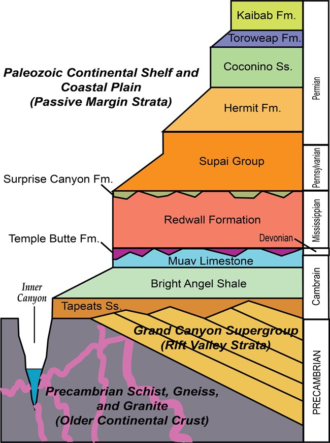
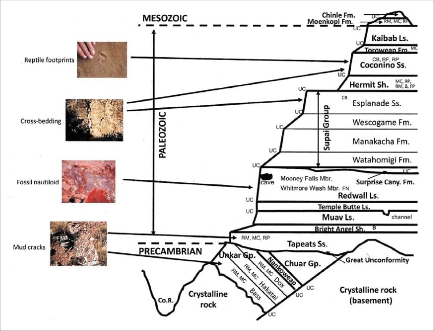
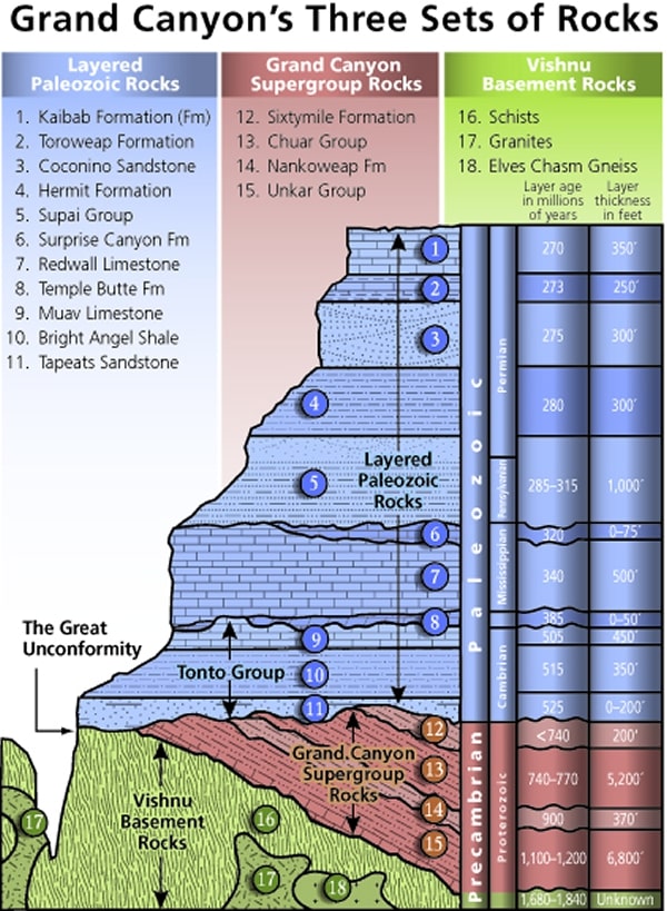
Mnemonic for the basic GC layers - Know The Canyons History, Study Rocks Made by Time
Know - Kaibab Limestone
The - Toroweap Formation
Canyon's - Coconino SS
History - Hermit Shale
Study - Supai Group (including the Esplanade)
Rocks - Redwall Limestone
Made - Mauv Limestone
By - Bright Angel Shale
Time - Tapeats SS
Know The Canyon's History, Study Rocks Made By Time.
Check the links section for lots more geology stuff.
Here are versions of this basic schemata:
| ||||
| ||||
| ||||
the geology of the Grand Canyon by the NPS (23mb pdf file)
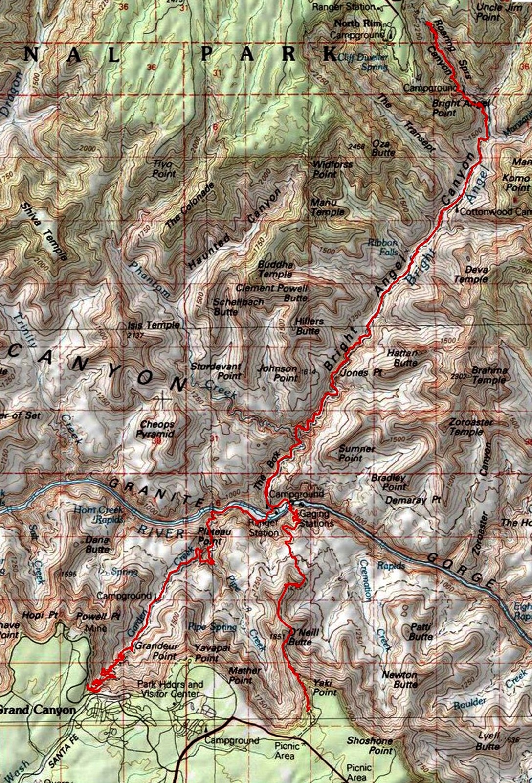
Grand Canyon Panorama Project - by Larry Wieland, South Kaibab Trail. You can see the area I hiked by visiting this site. There are many options - click on the spheres to go to a panorama from that point. There are several panoramas taken from the South Kaibab, for instance. Options also include: Add geology or topo map. A super series of panos and supporting geology maps. Of course, panoramas are available for the entire corridor trail system. Grand Canyon Panorama Project - South Kaibab Trail (link here).
| ||||
 |
 |
 |
Day 2: Lilting to Cottonwood.
7.5 miles + 3 to Manzańita and back = 10.5 miles, ERM of 15. Camp @ 4040'.
From 2500' to 4040' at Cottonwood to 4400' at Manzańita.
The tinkling of Cottonwood leaves glancing off the top of the tent reminds
me of rain and serves to stir me for the Day 2 jaunt. Out the open TarpTent door, I can see bright starlight fading.
Delightful dark sky wonders. Time to become upright and greet the day.
A large Mule Deer buck is thrashing the willows and eyeing nearby does. "Hey
guy," I suggest, "it's December, time to concentrate on making it through the Winter." His antlers seem a bit misshapen,
and I wonder about inbreeding in The Canyon because it doesn't seem there's an adequate number of deer to foster
proper genetic diversity.
It's a solitude without trump runners day. Spectacular. trump runner? Yes, me,
Me, ME! rim runners, without trail etiquette or even recognizing that others are on the trail. I might say narcissistic, self-centered,
ego driven, and selfish, but I won't. R2 have lots of excuses about how come they always have the right of way. Their motto
seems to be "I am happy to share the trail, without excuses, as long as I always have the first turn."
Today, I'm happy to be sauntering solo. It's quiet. It's safe to look around and gawk.
Each corner I come around, I automatically scan ahead, and, seeing no trump runners, a wide grin spreads over my face.
Grinning, grinning, grinning. So much grinning, grinning, grinning. Are all rim runners trump runners? No, yet it seems a
majority are. Despicable.
Part of the issue, concern, and problem is that there are too many R2 in The
Canyon. It's way past time to limit the number of R2 in The Canyon. I propose a maximum of 50 permitted R2, split
between North and South Rims. No North Rim access? Twenty-five it is, from the South Rim. And yes, permitted, that
is having an official paid paper NPS permit. Yes, for day use, anyone below the Tapeats Sandstone level. Unfair? This is
not a freedumb without responsibility situation. We backpackers have a paid permit, so should hikers below the Tapeats
Sandstone level because it's good for resource protection and visitor experience - remember the mission of the NPS?
The National Park Service mission statement is to "preserves unimpaired the
natural and cultural resources and values of the National Park System for the enjoyment, education, and inspiration
of this and future generations." This is difficult, if not impossible, with the uncontrolled onslaught of R2.
It's very cool lilting in the breezy Box, alongside BA Creek. Cool experience,
cool temperature too. Natural quiet surrounds, the sizzle surround sound of moving, tumbling water bouncing off the
close in walls of the Box. Glorious.
A Dipper dips and bobs on a polished rock in Bright Angel Creek, then
flies on stubby wings into a small waterfall. Looking for breakfast.
As I'm talking with Jake (NPS compost crew) and then Kate (NPS interpretation),
a chill comes over The Canyon. A solid cloudbank follows as I scurrying past the trail which leads to a wade of BA Creek
on the way to Ribbon Falls. The Ribbon Falls bridge is twisted and wrecked. No passage this direction.
Upper and Lower Ribbon Falls article. pdf - click here
I'm feeling pleased that the only people I see on the way to Cottonwood are NPS folks.
I setup camp in a site well protected from roving winds, then tour the area,
evaluating our work on the Cottonwood Ranger Station. It seems to be holding up well.
Link to the report about the Cottonwood Rehab Project Report click here.
Up the 1.5 miles to Manzańita Reststop, I chug, exploring.
I have a nice chat with Dan of the NPS trail crew, who are repairing a blowout from
yet another pipeline break. This Park and all public lands need and deserve investment to maintain them for future generations.
Republican strategy is to starve and degrade the Parks and other public lands to the point where they are in horrible condition,
then blame this on the government (yes, it's the repulsicans that are doing this - although they are not interested in governing,
they are interested in widening the income inequality gap), and circularly conclude that private corporations or private ownership
will do soooo much better. Insert expletive describing such callous nastiness here ______.
Back in camp, Sean is cooking with a self-fashioned Vienna sausage alcohol stove he
constructed in the parking lot after discovering that the South Rim General Store didn't have any isobutane canisters. Not optimal.
I offer some cook time on my stove, yet he replies that he likes a challenge.
Ryan and friend roll quickly in at dusk after a full day sortie to the North Rim.
There's a total of 5 campsites in use tonight. Nice and quiet.
A salmon pink sunset briefly adorns the Western sky, providing a colorful end to daylight
and a hearty harbinger for the hike tomorrow. Or so I hope
| ||||
| ||||
 |
 |
 |
 |
 |
 |
Day 3: Supai Snow Swirling. Or, visiting a host of Scenic Toilet porches. To
the Supai Tunnel and back. 9 miles, ERM of 15. Cottonwood Camp again.
4.5 to Supai Tunnel. Supai Tunnel at 6840' = elevation gain of 2800 '.
The first person I see today is Forest, working the trail with the NPS.
He's rigging the overhead trolley rope to haul small boulders from the streambed below to the wall being built on the hillside. Clever.
I pause at Manzańita for a liter of water and chug up the trail, wind buffeting
and making the right clothing combination difficult to find. Roaring Springs leaps from the Redwall/Muav interface and
currently forms the source for North and South Rim water. The light has been flat all day, yet nevertheless I try for a
short video. I wonder, did I see flakes of snow fly past?
Waves of grapple swirl around the Redwall Bridge. Yikes, the storm intensity
appears to be building.
It's clear that conditions are drastically deteriorating, so I opt for having lunch
under the awning for the Supai Tunnel Scenic Toilet.
Cold. My fingers feel frozen, and the Snickers bar certainly is. I put the Snickers
in my pocket to thaw and turn my attention to an apple fruit pie (yummy) and a Cliff and a protein bar. The Snickers snaps
despite the warming and this affirms that it's time to move, if I can.
The intensity of the snow increases and the temperature plummets, more. Burr.
With nothing to prove, I start back.
When my teeth stop chattering and I regain finger function, the snow lofting
upward from Roaring Springs Canyon is beautiful.
Rain gradually replaces snow below the Redwall.
Now I'm enjoying another snack on the covered porch of the Manzańita Scenic
Toilet. It's nice to be mostly warm and out of the drizzle. A Canyon Wren works the Muav Limestone a few feet away,
staying under the overhanging rocks. Using his bird brain well.
The drizzle turns to rain on the leg to Cottonwood Camp and I hastily reset the
tent (I've been using the hiking poles, which double as tent poles) and again seek shelter on a scenic toilet porch, this time
the Cottonwood Scenic Toilet. It's alternating rain and snow, ick. My body says it's time for another snack.
The sun appears just before sunset, highlighting a wet cold day. As I slip into
the tent, I note that there is ice on the inside and outside of the fly. Yikes.
| ||||
 |
 |
 |
Day 4: IG Ice Capade. To Indian Garden (IG).
13 miles, ERM of 19. Camp @ 3760'.
Claw fingers attempt to open the frozen Platypus. Argh. Ice coats the
tent. Double argh. The water containers stored under the tent vestibule are frozen nearly solid. It's a bit of a
struggle getting through breakfast and packing. Everything takes longer with frosty phalanges and frozen gear.
With feet like boards and curled hands (Raynauds Syndrome), I set out
at a fast pace to warm up. I'm guessing that it's about 20°F this morning. The mittens stay on, with four layers on
the torso until I'm in the sun of Phantom.
Again, it's delightful traveling through the Box. The only people I encounter
are the NPS Fisheries crew heading to shock and remove trout from BA Creek above the Box. Give native suckers a chance.
Yikes - there's ice beneath the faucet at BA. Yet its decently warm in the full
sun. Yes, sun. You know, that heater in the sky? Even so, I have on the wool hat during a lunch break in a sunny
campsite near the pomegranate tree.
I'm able to dry the groundsheet during lunch, while the other damp or
still frozen gear will wait until IG.
I set out up the BA Trail, which is mostly in the shade this time of year.
It's wonderful to have some direct sun, which lasts only until I get across
the Silver, BA, Bridge. And it's a quiet trail up to IG and I make decent time, hanging the tent and bag as soon as I arrive.
There aren't many hiking hours this close to the Winter Solstice, so I have
limited time to explore. Ranger Kate rolls in at sunset and we chat and watch the Canyon colors fade from the deck of
the IG Ranger Station. One of the topics we discuss is the difficult choice young people of today have about education
that saddles one with crushing debt. The repulsican plan is to give tax breaks to the uber wealthy and corporations,
while dems want those in the next generation educated or skilled in a trade and advancing the country. There are really
a lot of differences between the parties. I cook dinner and fix a hot water baby as a full slate of Winter stars illuminate
the desert sky. See the IG deck construction here
See the IG deck replacement project here click here.
 |
 |
 |
 |
 |
 |
Day 5: Up and Out. To the South Rim. 5 miles + 3 to Plateau Point, total of 8 miles, ERM of 11.
Total = 49.5 miles, ERM of 79
A buck deer huffing and chortling wakes me in the night. At first I wonder if a Cougar is stalking the deer, there are so many yearlings in the camp. Nope, it's an amorous buck. Again he's at it when the first sprinkle of rain kisses the tent just before dawn.
Although the sprinkle is but a warning, it's lovely to have a camp with the refurbished ramadas at IG. So I wrap up the tent and lounge under the shelter, watching the poor lighting on rocks made by time and slurping a mocha grandé that also warms the hands. Deluxe.
Link to refurbishing the ramadas here click here.
I opt to allow the day to warm and hike out to Plateau Point. It's dark
and cloudy, yet the trip is still worth it. I'm the only hiker on the Plateau Point Trail today and this is sheer loveliness.
A ray of light appears just as a buck deer is shifting to the other side of the trail to chase a doe. That's about it for
the light today, this and brief bursts of light on portions of the North Rim layers.
After final packing, I start the climb through the layers of rocks made
by time. In the Supai Formation, I scan the trailside boulders, looking for the oldest tracks in The Canyon. I find
them and sit down briefly to imagine their origin. Communing with my ancient lizard-like ancestors is my kind of genealogy.
More up, yet still in the Supai layer, I photograph the pictographs (rock art)
enduring under a peaked boulder. Hand prints and figures - what does it mean? Was this some sort of guide to Canyon
features? A guide to water or places to hunt or good camping? Perhaps ceremonial, spiritual? There's more rock art
in the Kaibab Limestone, mostly to the top of this trail that takes advantage of a fault and was a Native American route.
It's up and up, up into snow at the 1.5 mile rest house. Colder, temperatures
dipping below 30°F as the snow-covered trail winds through the Coconino Sandstone. The population density increases
as I approach the South Rim, many day trippers not practicing social distancing or wearing masks when they closely
encounter others. This MAGAvirus pandemic is likely to continue for another year, perhaps more. Both of these
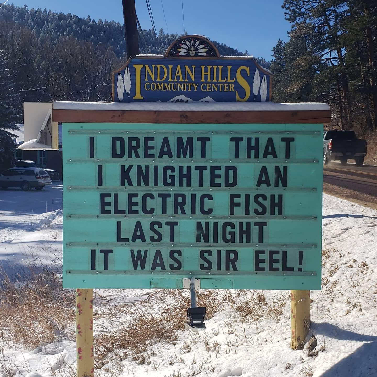
issues are foremost, as noted by the sharp guy who updates the outside board at the Indian Hills Community Center
"2 factors affect viral spread, population density and population density." Well put, yet still sad and deplorable.
Gaining the rim, there is sun and visitor polished ice and a piercing wind, a
fitting conclusion to ice capades in The Canyon.
Oldest tracks in the GC: Approximately 310 million years ago, a pre-amphibian or early reptile-like animal walked the sand that would become the Supai Formation with an unusual diagonal gait. It's a distinctive “lateral-sequence” walk, meaning their front and rear legs on one side moved before the front and rear legs on their other side moved. Was it walking on a dune? In a huge wind? Around a mound? Paleontologists have yet to determine what these tracks tell us, yet they are fascinating. If you look carefully, you'll see them in the Supai Formation. More about these tracks in the links section.
South Kaibab Trail: The NPS, National Park Service, obtained control of The Canyon in 1919 and, being frustrated with Cameron's toll road on the Bright Angel Trail, built their own trail, the South Kaibab. It's a ridge route rather than a canyon or fault route like most GC trails. Initially, the South Kaibab Trail was called the Yaki or Yaqui Trail because it started at Yaki Point. The name was later changed to the name of the nearby national forest, the North Kaibab. The name "Kaibab" reportedly is derived from Paiute for "Mountain Lying Down,” which is their name for the Grand Canyon. The Arizona Trail, a National Scenic Trail, uses the South and North Kaibab Trails as it rambles 800 miles from the Mexico to Utah border across Arizona and through The Canyon.
Bright Angel Tail: This major corridor trail takes advantage of the Bright Angel Fault, much as the native peoples
did. A well-worn path existed before being "developed" by Cameron. The Havasupai used this route and farmed
around the perennial waters of what is now called Garden Creek, at Indian Garden Campground and Ranger Station,
about 5 trail miles below the South Rim.
In the late 1880s, prospecting partners Pete Berry and Niles and Ralph
Cameron improved the BA trail at a cost of $500 in order to better reach mining sites within the Canyon. In February
of 1891, Berry registered it with Yavapai County as the “Bright Angel Toll Road,” though it was often known also as
“Cameron’s Trail” because Berry transferred control of the trail to Ralph Cameron. Cameron quickly turned to
mining tourists and charged a toll to use the BA Trail.
After many attempts to buy out or administratively move Cameron out
of Indian Garden and off the BA Trail, Santa Fe Railroad developed the Hermit Trail in 1910 to take visitors to their
facilities in the interior of the Canyon at Hermit Camp, while the frustrated NPS constructed the South Kaibab Trail
to provide free rim-to-river access and an alternative route to Phantom Ranch.
Finally, in 1928, Coconino County agreed to cede control of the trail to the
National Park Service in exchange for a new approach road to the park. The NPS subsequently rebuilt much of the
BA trail so it has a more uniform grade. The work was done by members of the CCC, Civilian Conservation Corp,
and Havasupai workers. More at:
https://grcahistory.org/sites/rim-to-river-and-inner-canyon-trails/bright-angel-trail/
 |
 |
 |
 |
 |
 |
 |
 |
 |
 |
 |
 |
| ||||
.
Trickle down does not work, no leadership on the MAGAvirus, and other republican damage that is killing Americans:
Meanwhile, trump and his enablers continue to inflict awful damage on the
American people, refusing to protect them (remember that oath of office?) and acting only in their self-interest.
Here's what Heather Cox Richardson said about this on December 17th, 2020:
"The reality that Joe Biden is about to become president and Kamala Harris is about to become vice president is sinking
in across Washington, and today gave us some indications of what that’s going to mean.
Stories about what exactly happened in the Trump administration are coming out,
and they are not pretty. Politics trumped everything for members of the administration, even our lives.
Today Representative James Clyburn (D-SC), who chairs the House Select Subcommittee
on the Coronavirus Crisis, revealed documents from senior appointees in the Trump administration overriding the work of the
career officials in the Centers for Disease Control and Prevention. Those documents show that the political appointees at
the Department of Health and Human Services called for dealing with the coronavirus crisis by pursuing a strategy of “herd
immunity,” deliberately spreading the coronavirus to try to infect as many people as possible, with the theory that this
approach would minimize the dangers of the pandemic. While doing so, they downplayed what they were doing, tried
to hide the dangers of the virus, and blamed the career scientists who objected to this strategy for the rising death rates.
Although the White House has tried to distance itself from senior Health and
Human Services Adviser Paul Alexander, last summer he was widely perceived to speak for his boss Michael Caputo, the
Health and Human Services Assistant Secretary for Public Affairs whom Trump had appointed, and for the White House
itself. Alexander, a part-time university professor from Canada, defended Trump against scientists, accusing CDC Principal
Deputy Director Dr. Anne Schuchat of lying when she provided accurate public information about the worsening
pandemic. When she suggested everyone should wear a mask, he claimed: “her aim is to embarrass the President.”
Alexander attacked Anthony Fauci for his attempts to protect Americans. “He just won’t stop!!!!!!!!!!!!!!!!” wrote
Alexander on July 3, 2020 (yes, I counted the exclamation points); “does he think he is the President???”
Alexander advocated spreading the infection to younger Americans: “So the
bottom line is if it is more infectiouness [sic] now, the issue is who cares? If it is causing more cases in young, my word
is who cares…as long as we make sensible decisions, and protect the elderely [sic] and nursing homes, we must go on
with life….who cares if we test more and get more positive tests.”
Alexander wrote to Caputo: “There is no other way, we need to establish herd,
and it only comes about allowing the non-high risk groups expose themselves to the virus. PERIOD.” On the same day,
he wrote: “Infants, kids, teens, young people, young adults, middle aged with no conditions etc. have zero to little
risk….so we use them to develop herd…we want them infected…”
On July 24, he wrote to FDA Commissioner Stephen Hahn and Caputo: “it
may be that it will be best if we open up and flood the zone and let the kids and young folk get infected” as a strategy
to get “natural immunity…natural exposure,” an argument that illuminates Trump’s insistence this summer that
schools and colleges must open.
But the idea that young people are safe from the virus is wrong. Today, an
article published in the Journal of the American Medical Association reported that while Americans older than 65 have
borne the brunt of the coronavirus, young adults are suffering terribly. From March through July, there were almost
12,000 more deaths than expected among adults from 25 to 44. Young Black and Hispanic Americans make up not just
a disproportionate number of that group of victims; they are a majority. Those extraordinary death rates have continued.
Younger adults are indeed endangered by the coronavirus; the idea it is harmless to them “has simply not been borne
out by emerging data,” doctors Jeremy Samuel Faust, Harlan M. Krumholz, and Rochelle P. Walensky—Biden’s pick to run
the CDC-- wrote in the New York Times today.
Another report today showcases two former CDC political appointees who are
now speaking out to call attention to the silencing of career scientists at the agency. Kyle McGowan, a former chief of
staff at the CDC, and his deputy Amanda Campbell watched as political appointees in Washington ignored scientists,
censored doctors’ messages to the public, and cut the agency’s budget. “It was… like a hand grasping something, and
it slowly closes, closes, closes, closes until you realize that, middle of the summer, it has a complete grasp on everything
at the CDC,” McGowan told New York Times reporter Noah Weiland. “Every time that the science clashed with the
messaging, messaging won.”
Politifact, the Pulitzer Prize winning fact-checking website from the Poynter
Institute, named the downplaying and denial of the seriousness of coronavirus its “Lie of the Year.”
Today it became clear the administration dropped the ball in other important
ways. We have more information now about the extensive computer hack that appears to have been conducted by
operatives from the Russian government. It’s bad. Hackers placed malware on commercial network management
software upgrades to gain access to government computers, along with those of major U.S. companies, as far back
as last March. They have been able to root around in our secrets for months. Hackers accessed the Treasury and
Commerce Departments, the State Department, the Department of Homeland Security, and parts of the Pentagon,
among other targets. The intrusion was discovered on December 8, when the cybersecurity company FireEye
realized it had been hacked and alerted the FBI.
Today the FBI, the Cybersecurity and Infrastructure Security Agency
(CISA), and the Office of the Director of National Intelligence (ODNI), issued a joint statement acknowledging “a
significant and ongoing cybersecurity campaign” and indicated they are not sure yet what has been hit. “This is a
developing situation, and while we continue to work to understand the full extent of this campaign, we know this
compromise has affected networks within the federal government.” It is clear the U.S. has been hit hard: Trump’s
National Security Adviser Robert O’Brien has cut short an overseas trip to come home and deal with the crisis.
In the New York Times, Thomas P. Bossert, Trump’s former Homeland
Security Adviser said, “the magnitude of this national security breach is hard to overstate.” He insisted the U.S.
must call out Russia for this attack (assuming it is confirmed that that country is, indeed, behind the attack). “Trump
must make it clear to Vladimir Putin that these actions are unacceptable. The U.S. military and intelligence community
must be placed on increased alert; all elements of national power must be placed on the table.”
“President Trump is on the verge of leaving behind a federal government,
and perhaps a large number of major industries, compromised by the Russian government. He must use whatever
leverage he can muster to protect the United States and severely punish the Russians.”
The New York Times called this breach “among the greatest intelligence failures
of modern times.” Senator Richard Blumenthal (D-CT) called it “stunning.” “Today’s classified briefing on Russia’s
cyberattack left me deeply alarmed, in fact downright scared. Americans deserve to know what’s going on,” he tweeted.
Blumenthal also recognized the severity of the coronavirus early: he tweeted on February 25: “This morning’s classified
coronavirus briefing should have been made fully open to the American people—they would be as appalled & astonished
as I am by the inadequacy of preparedness & prevention.”
And yet, there are signs that the country is reorienting itself away from Trump
and modern-day Republicanism.
Former New Jersey Governor Chris Christie, previously a staunch Trump
supporter, has released an advertisement urging people to wear masks and admitting he was wrong not to wear one
at the White House. It seems likely he is eyeing a future presidential run, and clearly is calculating that it is wise these
days to distance himself from Trump’s anti-mask politics.
Senate Majority Leader Mitch McConnell (R-KY), who has refused to advance
a coronavirus relief bill since the House passed one last May, seven months ago, is now trying to make a deal that includes
direct payments to Americans hurt by the pandemic. He explained to Republicans today that Republican senate candidates
Kelly Loeffler and David Perdue, who are running against Democrats Raphael Warnock and Jon Ossoff in Georgia, are
“getting hammered” because the people want the bill and the Senate is holding it up.
Finally, Bloomberg last night ran a story by journalist Craig Stirling highlighting
the work of economists David Hope of the London School of Economics and Julian Limberg of King’s College London, who
examined the concept of “supply side economics,” or the “trickle down theory.” This is the economic theory popularized
in the 1980s saying it’s best for the economy not to support wages at the bottom of the economy—the demand side—but
rather to free up capital at the top—the supply side—because wealthy entrepreneurs will create new jobs and the resulting
economic growth will help everyone. This idea has been behind the Republicans’ forty-year commitment to tax cuts for
the wealthy.
In their study of 18 countries over 50 years, Hope and Limberg concluded that
this theory was wrong. Tax cuts do not, they prove, trickle down. They do little to promote growth or create jobs. Instead,
they mostly just help the people who get the tax cuts."
.
*ERM: Energy Required Miles, are there data to support this
mileage adjustment?
Journal of Outdoor Recreation, Education and Leadership
Petzoldt first proposed his theory in his 1976 book “Teton Trails” to
help backpackers plan trips and calculate their energy needs on mountain trails. “Petzoldt defined one
energy mile as the energy required to walk one mile on the flat. He recommended adding two energy miles
for every 1,000 feet of elevation gain, so a person hiking one mile and 1,000 feet upward would use the
equivalent of three energy miles,” Phipps said.
Petzoldt’s energy mile theory was just a reflection of the mountaineer’s
“gut feeling,” Phipps said. The theory had never been tested in a laboratory before the study began in WCU’s
Exercise Physiology Laboratory in the spring of 2010, Phipps said.
To determine the validity of the theory, the study measured the energy cost
and perceived exertion for walking on flat ground, with and without a 44.5-pound backpack, and up an elevation
gain of 1,000 feet, with and without the backpack, through the collection of metabolic data, Phipps said.
Twenty-four student, faculty and staff volunteers, including 12 males and 12
females, went through four testing sessions as the research continued into fall semester of 2010. The study
results showed that the additional energy cost for ascending 1,000 feet ranged from 1.34 to 2.02 energy mile
equivalents, for an average of about 1.6 miles, compared to Petzoldt’s use of two energy miles for each 1,000
feet. The range revealed by the study was due to the “hikers” personal weight differences, Phipps said.
“It is remarkable that Petzoldt’s energy mile theory is so close to the actual energy cost measured during our
study,” Phipps said. “In the field of outdoor education, it’s important for leaders to include an estimation
of energy requirements during the planning of hiking trips.”
Phipps said the energy required for hiking up steep mountain trails would vary
for individuals and groups, and the variables of the trail would also factor in, but he recommends that
backpackers stick with Petzoldt’s idea of adding two energy miles for every 1,000 feet of elevation gain when
planning trips.
The Validity of Petzoldt's Energy Mile Theory, 2010
Authors: Maridy McNeff Troy, Maurice L. Phipps
Publication: Journal of Outdoor Recreation, Education, and Leadership
.
Links:
Link to all WV trip reports about The Canyon (WV)
South Kaibab Trail description - pdf (NPS)
North Kaibab Trail description - pdf (NPS)
Bright Angel Trail description - pdf (NPS)
Grand Canyon Panorama Project - South Kaibab Trail (link here - and access to other Canyon panos)
the geology of the Grand Canyon by Canyon Dave
the geology of the Grand Canyon by the NPS (23mb pdf file)
Oldest tracks in the GC, National Geographic article
Falter - Has the Human Game Begun to Play Itself Out on this Eaarth? by Bill McKibben
Other WV reports about the Grand Canyon:
Click here or on the Looking Lizard to go to all WV reports about The Grand Canyon
| ||||
More Truth Than Joke:
| ||||
| ||||
| ||||
| ||||
| ||||
| ||||
| ||||
| ||||
| ||||
| ||||
| ||||
| ||||
| ||||
|
Wild Vagabond Main |
Trip Report Index  |
Caveat  |
|---|