(April 24th to 30th, 2019)
Text © copyright by Rob; and Photos © copyright by Rob Jones of the WV

|
Grand Canyon /
B¾ucher Bound in The Canyon /
Visiting: Hermit Trail, Monument, Granite Rapids, Tonto Trail, Slate Creek, B¾ucher Creek and Trail
(April 24th to 30th, 2019) Text © copyright by Rob; and Photos © copyright by Rob Jones of the WV |
|
Co-Adventurer: Solo Adventure
Total miles = 49.8; ERM of 82. ERM = Energy Required Miles (see full description below).
camera: Panasonic DMC-ZS60
|
| |||||
|
| |||||
|
| |||||
|
| |||||
.
| ||||
.

| ||||
Introduction:
A bit of history, from the Arizona State University site, By Michael F. Anderson:
"The entire network of trails within Hermit Basin (aka Waldron Basin) is due to Louis D. B¾ucher,
an immigrant from Sherbrooke, Quebec, Canada who arrived at the canyonÆs South Rim before 1891, when other pioneers of the South
Rim were just starting to stake out their personal spheres of influence. B¾ucher chose the area about eight miles west of what
later became Grand Canyon Village, probably for the terrain, which allows multiple opportunities to descend through the typically
steep Kaibab and Coconino cliffs. He probably helped Dan Hogan and others build the nearby Waldron Trail about 1896, and another
early trail from HermitÆs Rest down past Sweetheart Spring to Hermit Basin about the same time. Unlike other canyon pioneers, he
did not immediately record his trails as toll roads, but did record his ōSilver Bell Trailö (the historic Dripping Springs and
Boucher alignments combined) in February 1902, only a few months after the Grand Canyon Railway arrived at the rim to the east.
Day 1: Monumental Cathedral Stairs. To Monument Creek, from Hermit Rest.
9.2 miles; ERM of 18. Camp @ 2990'. Hermit Rest TH at 6650', Monument Camp at about 2990'.
The B¾ucher Trail was one of the few named trails in the Grand Canyon I had not hiked prior to
this "B¾ucher Bound" adventure. So, I applied for a permit and, among four options with sliding start dates, I obtained a B¾ucher
permit. Having heard a variety of tales about how difficult this trail is, I decided to arrange the route so I would be going up the
B¾ucher. I can recommend this approach to you, especially if you want to stay a night on the Esplanade Extension - that point of
Esplanade (Supai) Sandstone below Yuma Point/Eremita Mesa. My rationale is that carrying yuge quantities of water up this degrading
route is easier than going down it with a full pack. Please refer to the NPS pdf file,
here -- B¾ucher Trail - NPS
or in the links section below describing the
B¾ucher (pronounced "bo¾-shay").
To add proper historical flavor to your own B¾ucher adventure, you might start by coming down
the Waldron Trail and ending your hike by exiting via the Dripping Springs/Silver Bell Route, making a true loop starting and ending
at the Waldron TH off the Rowe Well Road.
NPS Waldron Trail - NPS pdf.
You will want to get permission from the NPS to park overnight
at the Waldron TH. Note that the Silver Bell Trail has not been maintained for quite a few years. Patient and experienced hikers
will enjoy the solitude of this route.
So, following the GCHBA (Grand Canyon Hikers and Backpackers Ass.) volunteer service project in
The Canyon (link) and the completion of the quest to hike the AZT,
Arizona Trail (link here).
I am psyched to be bound for the B¾ucher.
B¾ucher is an enigmatic historical character, known after 1910 as ōthe hermit.ö There is little
doubt that he was eccentric, riding about the area on his pure white mule, Calamity Jane, and seemingly preferring his own company
to othersŚodd behavior for an early tourist guide. The Santa Fe Land Development Company apparently labeled him The Hermit after
they bought out his interests to build their own Hermit Trail in 1909, no doubt to add a little romance to their advertisements,
but he was not a true loner.
....despite his publicized proclivity for being a hermit, he has more canyon features named for
him than nearly all other pioneers combined: B¾ucher Creek, Canyon, Trail, and Rapids; Hermit Rest, Road, Trail, Camp, Fault,
Basin, Creek, Rapids, and Shale; and Eremita (Spanish for Hermit) Mesa and Tank. A hermit in life, perhaps, but in the afterlife
he is as well remembered as a rock star!"
I'm lounging in the shade of tall Tapeats Sandstone walls, my tired feet in soothing flip-flop
sandals, and relishing the distant background orchestra of Canyon Tree Frogs, bleating earnestly like sheep. Deluxe. Monument
Creek trickles nearby, while in the other direction sits the new Monument Scenic Toilet. Picturesque.
I start the day a bit late by Canyon standards and once on the Hermit, encounter Erin and Jayme,
on their way out after exciting Canyon times.
Soon, it's time for a footnote at Santa Maria Spring. Old (no longer in use) Scenic Toilets near
Santa Maria Rest House blend nicely with the surrounding rock. Synergism.
Air tour terrorists interrupt The Canyon experience as I drop deeper into the Supai level. A Canyon scourge.
The next group I meet is a covey of women on an REI adventure at Lookout Point. They all
seem thrilled at what they experienced during their adventure, telling tales of snakes and sunsets.
A Black-throated Swift zooms past, barrel-rolling with ease.
Redbud bloom against dark desert varnish on a Coconino Sandstone boulder.
Spiny Lizardo performs push-ups for bluster, perhaps parallax.
Chris and Clarisa, are visiting from the mid-East, Ohio.
I'll see them next at the junction of the Tonto and the Hermit Trail, and again at Granite Rapids.
Gold coats rocks made by time as local sunset slides more firmly over Monument Camp.
Day 1 photos - B¾ucher Bound


| ||||
Day 2: Granit¾ Rapidm¾. The Sandals Resort. To Granite Rapids. 4 miles; ERM of 6. Camp @ 2380'.
The Canyon Tree Frog Chorus has concluded their nightly performance and the Redwall bands above the
Monument Scenic Toilet are aglow.
Good morning from Monument Camp.
Mark rolls past on his way to "beat some of the blowtorch of Tonto walking," sporting his newly glued
boots. Mark reports that the sole came off his boot and the AZRA (Arizona Rafting) folks used their raft glue to reattach it,
avoiding cancellation of his trek to the North Rim and a big feast dinner at Phantom Ranch. Good and responsible people, those AZRA folks.
The muted rumble of Granit¾ Rapidm¾ becomes prominent, then primary as I drift down Monument Creek to
The River. The once absent creek flow re-emerges from the gravel and now hosts pods of pollywogs, hurrying toward adulthood. Squiggles
of quartz zigzag through the pinkish Zoroaster Granite in these polished streamside basement rocks.
Making my way upstream into the tammies and reintroduced cottonwoods, box elder, and willows (thanks
for this), I find terrific photo opportunities, complete with River reflections. Gorgeous.
I opt to lounge by The River, absorbing the rollicking, roiling, rambunctious River sounds while the
deep shade lingers.
Obnoxiously, the high decibel drone of air tour terrorists intrudes into the natural quiet of
Granit¾ Rapidm¾. Repulsive. Deplorable.
The anticipated lunch boat does not arrive as I while away the afternoon with limited exploring.
Still, it's a pleasant, reflective day at the beach, alongside The River in The Canyon.
Chris and Clarisa arrive and we cooperatively enjoy the shade.
It's growing hot until thunderclouds build and the temperature declines. We're still enjoying
this sandal day.
Moving camp to what I believe is a sheltered nook, I discover it's not when the twisting wind
sweeps in with the next front, filling the tent with sand. Sandals resort, sadly inside my tent. Calm returns and the growl of
Granit¾ Rapidm¾ returns to prominence. Billions of stars populate the sky when I look up not long before dawn.
Day 2 photos - B¾ucher Bound


Day 3: B¾ucher Rounder. To B¾ucher Creek. 10.2 miles; ERM of 15. Camp @ 2700'.
After climbing up from Granit¾ Rapidm¾ and Tontouring to the Hermit Creek area, I'm exploring
the historic Hermit Camp. I find the premier Scenic Toilet, staged in the open air so that users get a nearly 360 degree Canyon experience. Lovely.
Old cable works are found. I read somewhere that the cable was removed around 1926. Apparently,
the cable came down from near Hermit Rest (on the rim) to this camp in one span. Tent platforms can be seen, along with an old
cellar and corral. It is a good historical example of miners developing their mining claims on our land to mine tourists.
As I'm cooling my flattened, hot feet in the shade near Hermit Creek, I see something in the
periphery. A fat Chuckwalla is scaling the rock wall, apparently destined for the cracks and overhangs above. I twist and
try for a photo, yet Mr. Lizardo skitters over the edge above before I can get organized. He's probably inflated in a rock
cleft by now and removing him would be impossible. A passable photo results, just not what I hoped for. Cody and Aubree appear
to spend some down time on these smooth, glorious benches alongside Hermit Creek, dotted with Scarlet Monkey Flowers. It's a
day to add pinches of salt to the drinks - warding off hyponatremia (low blood sodium levels as a result of drinking too much water
without eating salty snacks), and the umbrella pops into action when leaving Hermit Creek.
A respite at Travertine Canyon is discouragingly brief because of encroaching sun. It's become
breezy with patches of cloud cover from building cumulus clouds.
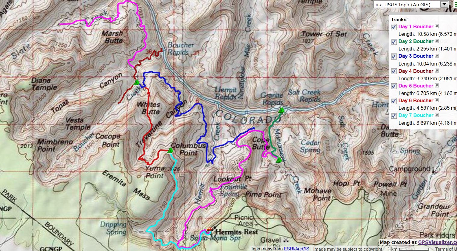
More Tontouring beneath Whites Butte to B¾ucher Creek and more lovely water. The water is
delightfully deluxe, although one leg of the stream by the main campsites comes from a travertine cave one passes on the way
down to the B¾ucher. I wonder if this increases the mineralization of the water and if this is a good thing.
I search unsuccessfully up and down B¾ucher for a less sun-exposed camp. Nothing. Earlier
trip reports mention Cottonwood trees at the creek, which are long gone. One of the bakers it is, with a local sunset time
of 5 p.m. Nevertheless, I don't stay at the main camps, instead searching among alternative sites on the bench SW of and paralleling
B¾ucher Creek. I find a meander in B¾ucher Creek below the historic remains of the B¾ucher Cabin that achieves early sunset and
lounge on a polished rock outcrop and gaze at rocks made by time until local sunset in camp.
It's well after true sunset when I finish chores and a refreshing salt-removing bath (bath at camp,
far from the frog-delighted stream). Ahh. The temperature and the distant froggy chorus are fine, fine at last. It's a joy to sit
nude drying on a square rock in the vestige of light and write these notes with the background baaing.
 |
 |
 |
 |
 |
 |
 |
 |
 |
 |
 |
 |
 |
 |
 |
 |
 |
 |
 |
 |
 |
 |
 |
 |
 |
 |
 |
 |
 |
 |
 |
 |
 |
Day 4: B¾ucher Rapidm¾. Explore to The River and up B¾ucher Creek. Another day at the beach.
6 miles, ERM of 11.
First, I locate the remains of the Hermit cabin and his prospect adit. There is little
to either because B¾ucher opted to mine tourists rather than minerals, the prospect existing to warrant claim to the area.
All evidence is gone of his fruit trees, and there is little remaining of this B¾ucher Creek cabin to remind us of this
famous figure, The Hermit, B¾ucher.
Lilting streamside along B¾ucher Creek's clear flow, froggies jump and Monkey Flowers bob
as I pass dry Topaz Canyon and continue down the B¾ucher toward B¾ucher Rapidm¾. Morning deep shade delights and soon the
distant rumble of B¾ucher Rapids (B¾ucher Rapidm¾) joins the creek music.
Along comes Blake, and as we talk, we are soon joined by Klaus and Hermann from the Black
Forest of Germany.
Klaus, Hermann, and I saunter down to B¾ucher Rapidm¾. This is their planned beach camp and
they find a small campsite at the down River end of the small beach. Because there is little room, I find a nook under a
sheltering Mesquite and enjoy some beach time swaddled in a wet shirt, the thunder of B¾ucher Rapids blotting out the
insidious cacophonous, clattering katzenjammer of the climate change accelerating air tour terrorists. Glorious place.
Oates, Mark, and Mike come along. They're also camping here near The River, then climbing
out of The Canyon via the B¾ucher Trail tomorrow.
Lounging continues into the heat of the afternoon, then I hike back to camp and from there up
canyon until surmounting the Tapeats Sandstone layer, at which point B¾ucher Creek dries up. Along the way are miniature Elves
Chasm settings, cascading water, burbling, Monkey Flowers, moss, idyllic.
Back at camp, I'm away from the main camps and have only the froggies chortling below and the
Hummingbird Moths to keep me company. Clouds fill in the twilight sky while bats begin their earnest flitter for food.
| ||||
 |
 |
 |
 |
 |
 |
 |
 |
 |
 |
 |
 |
 |
 |
 |
Day 5: A Gem of a Day. Tontouring the Tonto. To Slate Creek and Back.
11 miles; ERM of 13.
I call "may the shade be with you" to Klaus and Hermann as they pass the mouth of Topaz
below and I grind up onto the Tonto. Earlier, I talk with Oakes, Mike, and Mark about the sandstorm they experienced at B¾ucher
Rapids camp. Not fun. It was mostly calm in my camp nook, situated between gangly mormon tea and blackbrush and assorted shrubbery.
The Tontour on the Tonto is a delightful colorfest. The Tonto Trail endeavors to remain on the
contour as it Tontours The Canyon. The yucca and cactus families are blooming, as are the Mariposa Lily, Brittlebush, gold
something, Four O'clock, even the mormon tea blooms beneath the imposing Tower of Ra, looking on from across The River. The
River whispers from the depths as I stroll the slate blues and buffs of the Bright Angel Shale, held in position by the
resistant Tapeats Sandstone. This whisper may be the sound of Crystal Rapids, just downstream of where Slate dumps into The
River. Deluxe. Until the arrival of the money-driven motors, wrecking natural quiet wherever the corporate socialism allows.
Horrid. It must be 9 a.m. I'm talking about the air tour terrorists.
Wrapping up the water and lunch bag in the closed cell sitting pad inside the pack precedes the
unfurling of the umbrella. It's getting hot and the solar load is beyond noticeable. The reflective umbrella is popped into
action and adds comfort to this glorious morning.
Now I'm resting behind a large boulder at Slate Creek enjoying a boots off break and sucking down
extra water. Slate Creek is flowing well across the Tonto and provides air conditioned comfort (wet shirt and hat) along with
additional drinking water.
It's a quiet trail (except for the air tour terrorists), and I see no one since the Germans, early this morning.
The Cash Brothers' juniper is nearby, the place where I met this excellent duo many years ago -
they helped make the logistics of the -
John Muir Trail possible (link here).
Thanks Dave and Steve!
It's hotter on the return to B¾ucher, and windy too, making impossible the use of the portable shade umbrella.
Rats have attempted to defeat the rat sack, left in camp filled with food bags, cook pot and such;
rumpling the chain links and making a mess of some. Yet no food accessed. Damn rats.
 |
 |
 |
 |
 |
 |
 |
 |
 |
 |
 |
 |
 |
 |
 |
Day 6: Supai Slog. Natural Quiet Prevails! To the Esplanade Extension of the Supai layer, below Yuma
Point/Eremita Mesa. 4.3 miles; ERM of 11. Camp @ 5250'.
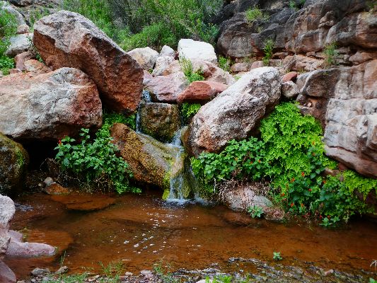
A double rainbow blossoms as the rain waves begin. The wind gusts hard, nearly ripping off the
pack cover, which is flapping around like a flag in a gale. I'm not wearing a rain jacket because I'd get as wet wearing one as being
out in the maelstrom. I chance photographing the rainbows, shielding the camera as best that I can. Soon, my shirt and pants are
hanging wet and limp. I rig an external codpiece from my handkerchief to shield the camera, which is also somewhat protected by my
angled body on the ascent and my yuge belly.
Into the Redwall break, where it's a bit slippery at times. Mostly, there's good gription in the Redwall.
The joy of inching the Redwall is accompanied by rain-washed desert aroma on the thin Whites Butte
plateau above the Redwall - Cliffrose and Lavender. There's fun in stretching legs on the contour of the Redwall top, then....
The Supai feels more difficult because of rock slides, unstable earth/rock sections, and because it
follows the Redwall climb. Now I'm getting soaked mainly from the wet vegetation rather than from the rain. Glorious, albeit cloud-
and low light-muted views await on the Esplanade Extension, the Supai nose below Yuma Point/Eremita Mesa.
Stopping at the first overlook jutting out above The Country, drizzle again sets in. Covering the
pack after putting the food in the rat-rumpled rat sack, I employ the umbrella and go to inspect the next point, apparently the one
with the elevation indicated on the USGS quad (5429'). I can see what might be a thin overhang in the Esplanade, just below more
tent sites. B¾ucher bonus! It's an overhang and a few more not as good overhangs. One could be a narrow camp, others - not
so much. I drag over the heavy pack and enjoy lunch #1 in the overhang while gazing at the distant Hermit Trail where it joins
the Tonto near Cope Butte, emerging from the Cathedral Stairs, The River growling through Granite Rapids - although the growling
I hear may be from Hermit Rapids, just out of my view. Then, all but foreground disappears as the next squall rolls through,
accompanied by thunder and, of course, more rain. The storm pulses have a special reward - air tour terrorists, here even nearer
and noisier, fly only between the pulses, and soon quit flying. Yahoo, something to be said for rainy days. Thunder rumbles, and
I can hear it. Amazing.
It's very cool, however, and I am wearing almost all I have, with the shirt still drying.
No happy Canyon moods yet today, as the moods change from sullen, to depressed, to angry and pensive.
The rain stops and I move topside, where I meet Sydni T. from texas who came down
without her hiking partners, who apparently bailed because of the rain. She plans to dayhike to B¾ucher Creek tomorrow.
Sunset accompanies a brief semi-clearing of the sky, and I try for a panorama and a video.
Then, clouds re-form and the wind cranks up, resulting in tying extra guys to the tent and
reminding me that I could have camped below the top ledge with fewer views but more wind protection. Then the rain resumes.
I'm comfy in my fluffy bag, finally using the full bag (not just as a blanket as I've done every evening except tonight).
| ||||
 |
 |
 |
 |
 |
 |
 |
 |
 |
 |
 |
 |
 |
 |
 |
Day 7: Return of the Hermit. To Hermit Trailhead @ 6640'. 5.1 miles; ERM of 8.
I sleep in to 6 a.m. or so. The gusts of wind have stopped, so I opt to get up and enjoy
breakfast. Rain patters in, so I retreat to the overhang for breakfast, dragging the entire pack along. Not much of a storm today.
Contouring on this section of the B¾ucher, the trail skirts above Hermit Canyon, sometimes
tenuously close to the canyon. Quiet and a bit wild in character, I'm enjoying this trail. The vertical wall holding up
Eremita Mesa occupies the West aspect while the abyss of Hermit Creek emphasizes the vacuum to the East. The Scenic Toilets
near Santa Maria Rest House can be (barely) seen across Hermit Canyon as the junction with the Dripping Springs Trail nears.
Dripping Springs Trail connects with the Hermit Trail and at this point I have completed the ranging loop and need only climb
out of this basin to the rim. I've been B¾ucher Bound and now hike the today quiet trail to the Rim, Subie Subaru, and home.
Day 7 photos - B¾ucher Bound


| ||||
 |
 |
 |
 |
 |
 |
 |
 |
 |
 |
 |
 |
.
*ERM: Energy Required Miles, are there data to support this
mileage adjustment?
Journal of Outdoor Recreation, Education and Leadership
Petzoldt first proposed his theory in his 1976 book ōTeton Trailsö to
help backpackers plan trips and calculate their energy needs on mountain trails. ōPetzoldt defined one
energy mile as the energy required to walk one mile on the flat. He recommended adding two energy miles
for every 1,000 feet of elevation gain, so a person hiking one mile and 1,000 feet upward would use the
equivalent of three energy miles,ö Phipps said.
PetzoldtÆs energy mile theory was just a reflection of the mountaineerÆs
ōgut feeling,ö Phipps said. The theory had never been tested in a laboratory before the study began in WCUÆs
Exercise Physiology Laboratory in the spring of 2010, Phipps said.
To determine the validity of the theory, the study measured the energy cost
and perceived exertion for walking on flat ground, with and without a 44.5-pound backpack, and up an elevation
gain of 1,000 feet, with and without the backpack, through the collection of metabolic data, Phipps said.
Twenty-four student, faculty and staff volunteers, including 12 males and 12
females, went through four testing sessions as the research continued into fall semester of 2010. The study
results showed that the additional energy cost for ascending 1,000 feet ranged from 1.34 to 2.02 energy mile
equivalents, for an average of about 1.6 miles, compared to PetzoldtÆs use of two energy miles for each 1,000
feet. The range revealed by the study was due to the ōhikersö personal weight differences, Phipps said.
ōIt is remarkable that PetzoldtÆs energy mile theory is so close to the actual energy cost measured during our
study,ö Phipps said. ōIn the field of outdoor education, itÆs important for leaders to include an estimation
of energy requirements during the planning of hiking trips.ö
Phipps said the energy required for hiking up steep mountain trails would vary
for individuals and groups, and the variables of the trail would also factor in, but he recommends that
backpackers stick with PetzoldtÆs idea of adding two energy miles for every 1,000 feet of elevation gain when
planning trips.
The Validity of Petzoldt's Energy Mile Theory, 2010
Authors: Maridy McNeff Troy, Maurice L. Phipps
Publication: Journal of Outdoor Recreation, Education, and Leadership
.
Links:
Link to all WV trip reports about The Canyon (WV)
the geology of the Grand Canyon by the NPS
Falter - Has the Human Game Begun to Play Itself Out on this Eaarth? by Bill McKibben
Other WV reports about the Grand Canyon:
Click here or on the Looking Lizard to go to all WV reports about The Grand Canyon
| ||||
More Truth Than Joke:
| ||||
| ||||
| ||||
| ||||
| ||||
| ||||
|
Wild Vagabond Main |
Trip Report Index  |
Caveat  |
|---|