The AZT 2018, Part 2
Transcanyon Terminus on the AZT
Arizona Trail 2018 (Part 2 for 2018)
AZT mile 690.6 to AZT mile 788.7, a trail distance of 98.1 miles (ERM = 146)
Grand Canyon National Park,
North Rim, Kaibab Plateau, Buckskin Hills
May 17 to 27, 2018 (only hike days)
Text and photos
© copyright by Rob Jones
 |
Co-participant: Ron Watters
camera: Panasonic DMC-ZS60

|
|---|
Northern Terminus, Day 11
(Click the image for the full-size image)
|
|---|
|

|
|---|
The AZT, Day 11
(Click the image for the full-size image)
|
|---|
|

|
|---|
Spiny Lizardo, Day 1
(Click the image for the full-size image)
|
|---|
|

|
|---|
BA Babe, Day 1
(Click the image for the full-size image)
|
|---|
|
|

|
|---|
Lizardo - Lizarda Cavorting, Day 2
(Click the image for the full-size image)
|
|---|
|

|
|---|
Ron at Ribbon Falls, Day 2
(Click the image for the full-size image)
|
|---|
|

|
|---|
Grand Canyon Pink, Day 2
(Click the image for the full-size image)
|
|---|
|

|
|---|
N Rim (Ed Abbey) LO and Scenic Toilet, Day 5
(Click the image for the full-size image)
|
|---|
|

|
|---|
Movie: Behind Ribbon Falls 25mb, Day 2
(Click the image to see the short video)
|
|---|
|
"Anarchism? You bet your sweet betsy.
The only cure for the ills of democracy is more democracy. Much more." - Edward Abbey
Summary: Ron and I backpacked from the South Rim of the Grand Canyon,
through The Canyon to the North Rim, then across the North Kaibab Plateau and Buckskin Hills to the
Arizona-Utah line, the top (Northern) terminus of the nearly 800 miles long Arizona Trail. Transcanyon
to the Terminus.
For me, this adventure completes 90.9% of the Arizona Trail, AZT, and
only the first 86 miles of the AZT remain to be hiked. This venture will wait for moderate Spring
temperatures and (I hope) a decent water year.
We hiked from AZT mile 690.6 to AZT mile 788.7, a trail distance of
98.1 miles (ERM of 146), although the actual distance we hiked was greater. So, to date, I have hiked from AZT
mile 86.8 to 788.7; 701.9 AZT miles.
See all the sections I have hiked on the AZT by clicking on this link to
all WV trip reports about hiking the Arizona Trail.
Ron Watters - website, National Outdoor Book Awards: Yes, Ron is a writer
and publisher (with wife Kathy) and the originator of the National Outdoor Book Awards, NOBA. Need a recommendation
for books about being outdoor, including how to and children's books, see NOBA. From Ron's site, you
can learn about navigation (including map and compass use) and read some excellent stories penned by Ron. Here are
the links:
Ron Watters, main page.
National Outdoor Book Awards.
Background relevant to this trip report:
The AZT, Arizona Trail: Flagstaff's own Dale Shewalter, a fifth-grade
schoolteacher, walked what would become the AZT in 1985, after spending several years piloting trail sections.
The first section of the AZT was dedicated in 1988, starting from the North Rim of Grand Canyon National Park
and running for 54 miles toward Utah. Other segments followed, and the AZT was officially completed in 2011,
26 years after Dale pioneered the route and one year after he died. Numerous public land agencies (e.g., the
NPS, FS, BLM) and volunteer groups and individuals made the AZT a reality, starting with Dale's vision. The
need for trail and easement work are continuous along the 800 mile AZT, which travels through almost all C.
Hart Merriam's life zones as it rambles from the Mexico border to Utah.
Merriam and Life Zones: And who is C. Hart Merriam? As scientists
and nature lovers know, Dr. Clinton Hart Merriam, America's first bio-ecologist, established the Life Zone
concept in 1889 on the San Francisco Mountain of Arizona. When he was sixteen years old, Merriam accompanied
the 1872 Hayden Survey to Yellowstone, and was the founder and first chief of the U.S. Bureau of Biological
Survey, now the Fish and Wildlife Service. Merriam was the first to advance and define the Life Zone concept
in scientific terms. In his report on the San Francisco Mountain region (1890) he concluded that forms of
life are dependent upon altitude zones, and the designation of a region or zone by the presence of animals
and plants not found in other zones. Because temperatures on North slopes differ from those with Southern
exposure, life zones do not run on arbitrary contours. Latitude, the distance from the equator, is also
important in determining climate. This combination of altitude, exposure, and latitude (climate) is basic
in the ecology that governs the existing distribution of plants and animal indigenous to the various regions.
Merriam's concept was fundamental in the development of the science of
ecology, and is one of the most important modern generalizations in biology. As America's first bio-ecologist,
Merriam ranks in the top tier of American scientists. His "laws of temperature" establishing life zones and
life distribution were fundamental to the Life Zone concept.
Merriam divided the region into seven "life zones" because of differences
in their biology (resident plants and animals). Merriam's premise was that temperature was the largest
controlling factor in these life zones. Starting from the top of San Francisco Mountain to the lower Painted
Desert, he named these zones: (1) Alpine, (2) Sub-alpine, (3) Hudsonian or Spruce, (4) Canadian, (5) Neutral
or Pine, (6) Pińon, and (7) Desert.
The Merriam (wild) Turkey and the Merriam Elk (now extinct - due to
livestock overgrazing and market hunting) were named for him, Clinton Hart Merriam. Rocky Mountain Elk
were introduced in Northern Arizona in 1913 from Yellowstone National Park and are the Elk you see today
when wandering around San Francisco Mountain and across the Coconino and Kaibab NF (National Forest).
Yet, not on the North Kaibab along the AZT because there are no Elk on the North Rim.
From the NAU website I learned that the Merriam-Powell Center for
Environmental Research at NAU is helping to create the scientific knowledge and understanding needed to
address significant environmental challenges, including climate change and biodiversity loss. C. Hart
would be troubled by our inadequate response to climate change, yet a happy scientist that others are
pursuing the generalizations he formed while working out of the Merriam Base Camp along what is now the
Arizona Trail.
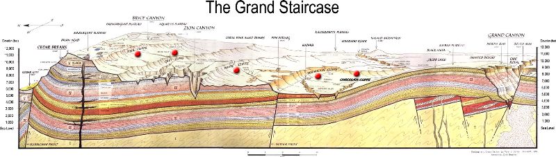
The Grand Staircase (from the NPS) is an immense sequence of
sedimentary rock layers that stretch south from Bryce Canyon National Park through Zion National Park
and into the Grand Canyon. In the 1870s, geologist Clarence Dutton first conceptualized this region
as a huge stairway ascending out of the bottom of the Grand Canyon northward with the cliff edge of
each layer forming giant steps. Dutton divided this layer cake of Earth history into five steps that
he colorfully named Pink Cliffs, Grey Cliffs, White Cliffs, Vermilion Cliffs, and Chocolate Cliffs.
Since then, modern geologists have further divided Dutton's steps into individual rock formations.
What makes the Grand Staircase worldly unique is that it preserves
more Earth history than any other place on Earth. Geologists often liken the study of sedimentary rock
layers to reading a history book--layer by layer, detailed chapter by detailed chapter. The problem is
that in most places in the world, the book has been severely damaged by the rise and fall of mountains,
the scouring of glaciers, etc. Usually these chapters are completely disarticulated from each other and
often whole pages are just missing. Yet the Grand Staircase and the lower cliffs that comprise the Grand
Canyon remain largely intact speaking to over 600 million years of continuous Earth history with only a
few paragraphs missing here and there.
Unfortunately, the Grand Staircase is such a vast region of rock that
no matter where you stand on its expanse, most of it will be hidden behind the curvature of Earth.
However, it is best viewed from Hwy. 89A north of Jacob's Lake, Arizona. Or, from the AZT.
|
|---|
The Grand Staircase
(Click the image for the full-size image)
|
|---|
|
Navigation: Mostly, we used paper maps for navigation. Because
the Atlas Guides (Guthook) AZT app is optimized for the i-smartass-phone, one using an android-smartass
(perhaps an i-smartass too?), such as me, does not realize that the app is not working properly until on
the trail, where updates are impossible. In the case of the current trip, apparently the app was updated
and new water reports were not visible in the version of AZT app in use. This resulted in my thinking
that there were no recent reports and that water sources were tenuous at best. Other aspects of the app
worked OK, yet the lack of timely water reports resulted in a great deal of extra planning and work to
place water caches, some that were superfluous. Disappointing. Fair warning, you AZT hikers.
ERM = Energy Required Miles: A mile is added for every 500'
elevation gain or loss. It's a very serviceable method of estimating energy required miles. ERM was
initially used in Trails of the Tetons (long out of print) by Paul Petzold, founder of NOLS. It's a
wonderfully useful concept and application. Add one mile for each 500' up AND down to distance = ERM.
I use ERMs to calculate what the actual day is like. It's a very serviceable method of estimating energy
required miles. Remember, however, that the ERMs are estimates because they depend on GPS satellite
coverage and math functions.
Using ERMs does not account for the 'texture' of the route or trail - that is, rocky, boulders,
no trail, slimy mud, etc., yet does help approximate the route.
See more information about ERMs at the end of this report.
Preliminary 1:
After months of sporadic planning, I'm on the road to the Kaibab Plateau; the Subie Subaru wallowing
under the dead weight of over 250 pounds of precious water. Because of the climate change "drought,"
Ron and I are caching water for all the sections of the AZT, Arizona Trail, on the Plateau. Also, I'm
caching water for Art (Karts) H., who is traveling the AZT not far ahead of us. And, there's water for
use in camp, making up the remainder of the water weight.
It's worrisome, this dry, windy weather and developing dry climate.
I find a high (8200') camp among the P-Pines (Ponderosa) along FR (Forest
Road) 205 and work on camp while waiting for Ron to arrive. It's chilly, yet the Pines break up the wind,
which is forecast to be 30 mph tomorrow. I'd prefer the moderate temps at Stateline Camp, yet there is
little to stop the wind and abrasive dust at this camp. It's quiet and I see only one turkey hunter on
my dirt road travels today.
I had drafted the food plan on the back of an envelope, prompting Ron to
send me an apropos quote. Ron arrives and we're chilled by the end of dinner. It takes my toes 20 minutes
to warm once in the fluffy bag.
"Any expedition worth doing can be
planned on the back of an envelope.". - Bill Tillman
Preliminary 2: Caching:
Wandering forest roads in search of pre-planned water cache points is the quest today.
Off we go on the 205 to the 249 and hike in a water cache. Back
on the 249 to the 247 to the Winter Road for a cache, and return on the bone jarring House Rock Valley
Road (BLM 1065), South to Hwy 89A and back to camp for a late lunch before caching two more locations
South of Murray Lake TH (trailhead).
Ron and I are both cooking potatoes and eggs with chilies and onions.
Culinary twins.
Once in the tent, the Song Dog (Coyote) serenade cuts through the clear
brisk air at 8200'.
Preliminary 3: Congestion to heaven:
We're still waiting for the queue of traffic to move along toward the North Rim NPS
(National Park Service) entrance station. Yikes a big traffic jam on the North Rim. After an
hour we are free of the snarl and exploring for the picnic area water cache. Deciding to defer
this decision, we trundle along to the North Rim Backcountry Information Center (BIC), where we
talk with Steve B about our Canyon plans. Steve has been a terrific resource for planning and executing
this jaunt. Thanks Steve!
The short story is that we are good to go. From here, a visit to the
campground hosts yields another positive - a place to store our resupply buckets. We'll resupply from
these buckets when we complete the cross-Canyon (Transcanyon) jaunt.
Perhaps a wager in the lottery is in order, given our fantastic success
today. Then we recall getting locked out of Ron's truck, and leave the wager to others.
Prelim Photos- AZT 2018, part 2
Preliminary 4: South Rim:
Today we enjoy 2 old fire lookouts complimented by scenic outhouses.
After finishing up the caching where the AZT crosses 89A, we bump
and bounce to Stateline CG, where Ron leaves his truck after carefully checking his pack. We see lookout
#1 and scenic toilet near Jacob Lake. As we're readying to go from Stateline, Mr. Cup, an AZT hiker from
Japan, puffs in talking about the heat of today.
Then the long drive around to the South Rim and to the Kaibab NF for dinner
and camp and the second of the combo of lookout and toilet. Grandview Lookout. The wind moans through the
P-Pines, occasionally ruffling the TarpTents. Yet, it's considerably warmer here at 6500' then the past
few nights. Yes, two TarpTents. Ron has a ProTrail and I have a Notch. U.S. designed and constructed by
a non-corporation. What else can you want except the functionality for which TarpTent is known?
Prelim Day 4 Photos- AZT 2018, part 2
.
Steve Chaffee, one of the excellent AZT Trail Stewards, has written
The Arizona Trail: Passages in Poetry (Link to Steve's book), Stephen N. Chaffee, 2018, Wheatmark Publishing.
You will see three of Steve's poems in this report, "Grand Canyon South Rim," "Grand
Canyon Inner Gorge," and "Grand Canyon North Rim"
(reproduced by permission of Stephen N. Chaffee).
|
|---|
Grand Canyon South Rim - poem by Steve Chaffee
(Click the image for the pdf)
|
|---|
|
Day 1: AZT 2008, Part 2, hike. BA Babe:
To BA, Bright Angel Camp. 9.5 miles. ERM of 19. (ERM is Energy Required Miles.)
Camp at 2600'.
The ramp retina BA Babe gazes googly eye at Ron and me sheltered by basement rocks
from the penetrating sun. BA Babe wiggles her nose, chunks off some desiccated brush and appears to ignore us.
Bighorn Sheep ewe, BA Babe.
We start out before sunrise at Grandview LO and soon we are rolling along toward
the BIC, Backcountry Information Center, to park my Subie Subaru. Deciding to hike down the BA, (Bright Angel)
to avoid some of the uncourteous rim-to-rim runners, we launch into The Canyon. Glorious.
The traffic is surprisingly mild and we arrive at Indian Garden and the Ranger
Station (RS) deck (replaced by us VIPs) to further absorb the Canyon ambiance during lunch #1 here is the link
to this volunteer (VIP) trip report. Along the way to Indian Garden, we meet
Ranger Betsey, who is hiking out to attend a meeting on the rim before hiking back in later today.
While on the RS deck, a blustering Spiny Lizardo postures with inflated neck
while doing pushups. Colorful guy. Two PSAR, Preventive Search And Rescue, guys come by and we talk about volunteer
ventures in The Canyon.
Off on the Old BA we continue, making our way to the next big break at the Pipe
Creek Rest House via this abandoned trail and part of the BA through the basement rocks (Zoroaster Granite and
Vishnu Schist). Another wet shirt helps ease the strain of the 95F temps. Soon, we're trundling over The River
on the Silver, BA, Bridge and into the streamside BA camp.
It feels great to be out of the sun and finished with hiking for the day.
Sjors the Master VIP, Volunteer In Park, comes by checking camps and we catch up
about all things Canyon. I'll see Sjors during the next volunteer venture.
Then, a proper BA Creek baptism refreshes, relieving the body of an extra pound
of salt.
BA Creek burbles as the golden light slides up massive layers of rocks made by time.
Starting out sleeping nude on top of the bag, I am cozied inside at the gray
blush of morning; the cool air slipping down canyon in the Bright Angel Fault.
Day 1 Photos- AZT 2018, part 2
Day 2: Dreadlocks and Tsunami. To Cottonwood Camp:
7.5 miles. ERM of 11. Camp at 4,000'.
The crystal water slides through the emerald green dreadlocks adhered
to the calcium carbonate cone; Ribbon Falls. A gorgeous falls in a stunning setting. Crisp, yet probably
contaminated water sluices past yellow and red Monkey Flowers, Canyon Tree Frogs, dragonflies, and through
verdant moss. Lovely. Chimik' yana' kya dey' the Zuni Tribe considers these waters an umbilical cord that
physically connects their place of beginning to their end.
(link to the AZ Daily Sun article about Ribbon Falls)
A tsunami of rim runners clutters the pool below the falls. Argh, can
Eaarth survive this glut? (Eaarth, Bill McKibben spelling and meaning.)
We start out peacefully this morning from BA and roll through a portion
of The Box. The Box rumbles naturally with the flow of Bright Angel Creek and the hiking is alluring and
wondrous. Stopping for a foot break and snack as The Box is opening, we note a colorful Spiny Lizardo and
his quest, a Lizarda, engaged in a display and romantic tussle. All is good. That is before the flood of
runners and trotters begins, becoming a hoard. Exhibiting their typical self-centered selfish ego driven
lack of trail ethics, it's a "me! me! me!, go, go go, I'm coming through" tsunami of single use users.
The concept of yielding to uphill hikers is quickly discarded when this group hits the trail. This continues
to Ribbon Falls, where a shocking number of rimmers are clogging the pool below the falls. I consider filtering
a liter of this sparkling water, yet reconsider given the bathers above. Instead, Ron and I enjoy another
snack in the diminishing shade after touring behind the falls.
As the heat builds toward the mid-90s, the rimmers become a bit more civilized
and they display a modicum of social reciprocity. Torpor?
Arriving at Cottonwood Camp, we find a horse and three people occupying the
stock camp, our camp for tonight. At 1 p.m., we wonder how the horsey is going to enjoy, or not, walking in
the high heat of the day. It does strike me as another form of inconsiderate behavior (to the horse, to us
pack mules) to get on the trail this late. It does seem to be a day of trumpian behavior, thankfully moderated
by this spectacular setting.
Voltaire had something to say about those that adore trump -
"If we believe
absurdities, we shall commit atrocities." - Voltaire
Ron and I hang out in the shifting shade provided by a large holly oak,
awaiting a bit of shade in camp and cooler temperatures.
Another two AZT hikers arrive at the stock camp. This will result in crowding,
and I end up by the mule hitch in the rocks and trump apples.
As the shadeless heat continues into the afternoon, I ease on down to the
Ranger Station in search of better shade, perhaps to partake of the BA jacuzzi nearby.
|
|---|
Grand Canyon Inner Gorge - poem by Steve Chaffee
(Click the image for the pdf)
|
|---|
|
Day 2 Photos- AZT 2018, part 2
Day 3: North Kaibab Ne'er-do-wells. To the North Rim Hiker-Biker Camp:
9 miles. ERM of 18. Camp at 8200'.
It's a glorious start just after sunrise from Cottonwood Camp, bound for
the North Rim over 4,000' above. Yet too soon there's a scourge of trail runners displaying their egomaniacal
selfish deportment. A scourge. Yes, a group of trail runners is a scourge. An exaltation of Larks, a murder
of Crows, a scourge of rim-runners.
Soon, we're sipping the sauce (of electrolytes) at the Manzanita Rest Area.
There's a group of Grand Canyon Association hikers cleaning trash from rim to rim, lead by Rebecca. Thanks guys.
Yikes, as soon as we rejoin the trail there's another scourge of impatient
runners. We pause for snack 2 in an alcove not far from the Redwall Bridge, and again at the Supai Tunnel,
each accompanied by a liter of water. From the Supai Tunnel, it's up through the Coconino Sandstone to the
Coconino Overlook, gradually climbing out of the heat and The Canyon. And out of the 95F temps and into the
realm of down jackets and wool hats.
Miraculously, we slip out between waves of scourge, a peaceful exit to an
ethical rim to rim.
At the North Kaibab TH, Ron and I take a survey about user interactions and
expectations of wild and other experiences. Dear reader, you might be able to guess how I completed this survey.
Then, a shower! after checking in for a camp. Yahoo. Chips and beer, yummy.
The view from camp may be the best in the campground, as we overlook part of
the Transept.
Day 3 Photos- AZT 2018, part 2
Day 4: Park North. To Lindbergh Hill. AZT 718.2:
7.5 miles, including campground and off trail hiking. ERM of 9.5. Camp at about 8860'.
The salmon hue plays across the cliff bands of the Coconino, Redwall, Supai
of the Transept as sunrise arrives. Another glorious look at The Canyon from our most scenic perch. Ron
and I take a relaxed approach to today after the good beating provided yesterday by The Canyon and because
we don't have far to go today.
We are just off the Transept Trail, heading to the Backcountry Office (BIC)
when a Subaru filled with 3 hikers and gear pulls up - Barry B., Fred, and Nan and gear are crammed in the
car and are also going to the office. We are going to the BIC to express our thanks to Steve while Barry
and group are going to get a permit to hike part of the Arizona Trail through the Park. We all enjoy our
discussion with Steve and make tentative plans to meet near Lindberg Hill. Nan is officially the oldest
woman, at 75, to hike the Appalachian Trail. Barry is a fellow volunteer and friend. We've shared several
Grand Canyon VIP adventures (link) http://wildernessvagabond.com/WV-GC-trip-links-all.htm . Fred is an
educator and once worked as a volunteer with Steve at Natural Bridges NM.
Eventually, Ron and I get over to the North Kaibab TH and onto the AZT.
Following an old telephone line corridor, now sprouting occasional cable pedestals, we enter the Ponderosa,
Fir, Spruce, Aspen forest of the Kaibab Plateau. Seeing no hikers today is an immense, yuge, contrast to
the cancer cell ideology of the rim to rimmers we suffered yesterday - endless growth, finally killing the host.
The irritation for today is the air tour terrorist fixed wing planes and
helicopters running their loops back out over The Canyon, extinguishing natural quiet outside the corridor
zone. Of course, the corridor should be like a utility corridor with all mechanized use concentrated there
and nowhere else, preserving natural quiet in the wild and primitive zones of the Park. But no.
We hike on and cross Hwy 67 and into our camping zone for tonight, zone NB9.
Finding a pleasant area over a bump near Lindbergh Hill, we establish camp and enjoy a low key afternoon.
It's a decent location because the bump helps screen out the highway noise and the wind. Barry, Nan, and
Fred join us for good conversation, dinner and overnight.
|
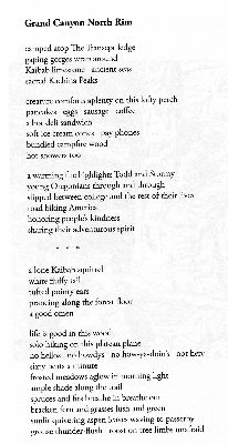
|---|
Grand Canyon North Rim - poem by Steve Chaffee
(Click the image for the pdf)
|
|---|
|
Day 4 Photos- AZT 2018, part 2
Day 5: Abbey's Way. To AZT 728.0:
Visit the North Rim Lookout. 9.8 miles. ERM of 14. Camp at 8990'.
Ed Abbey was here, here writing Black Sun, a novel, and sometimes
watching for forest fires. He used this old dilapidated scenic toilet, pulled out the bed frame under
the stars, and scuttled around inside this now falling down shack cooking and occasionally entertaining
guests. Amazing.
Ron and I climb the historic LO tower in the wind of this gray day. I feel
a bit cheated that we are graced with such a glum day for our visit to the way Abbey came.
We start today with light teasing conversation with Barry, Nan, and Fred.
Barry reports the overnight low as 32F. I did wake up with a cold nose several times. We will see them again
at the Park entrance station, where once again there is a tremendous population glut of visitors lined up
in a long queue awaiting views of the spectacular Canyon. Seven billion people can be and are wrong. I
leave a note for Ranger Steve, photograph the partly buried scenic toilet and continue on Abbey's way.
Now it's into early afternoon and we have stopped for lunch #2 in a
gently sloping grass lined canyon abutted by thick forests on both sides. Humm, I wonder aloud, how come
the trees don't encroach farther into this savanna? We have left the Park and entered the Kaibab National
Forest.
Not far below Sourdough Well Ron and I climb out of this North Canyon network
and soon arrive at camp for tonight. Cold pulses continue to drift past in the gray cloudbank above and it's
a chilly evening. Ron reports "I can still feel my fingers and I have on all my clothes, so life is good." A
dose of hot soup and a hot dinner help ease the evening.
Later, I learned a bit about how come the canyon meadows stay 'open?'
Subalpine meadows... factors of wet soil, colder air, longer frozen soil, high winds and blasting snow,
(over)grazing (sometimes beefaloo in this case!) all help prevent the spread of the conifers.
Day 5 Photos- AZT 2018, part 2
Day 6: East Rim Gluttony. To Little Pleasant Valley Tank. AZT mile 740.2:
12.2 miles. ERM of 14. Camp at about 8600'.
Raspberries and blackberries in coconut yogurt! Bison brisket bar. An apple.
Gingerbread date bars and an Indian veggies pouch and tortillas for later! All with a view into Lower House Rock
Valley and the shadowy gash of Marble Canyon, hiding the slithering Colorado River. Gluttony at the East Rim
viewpoint; courtesy of three female day hiker/campers we chat with near the scenic toilet serving the viewpoint.
Yummy.
We've hiked here from our AZT 728 camp on our way to Little Pleasant Valley
Tank.
Following a decent gorging, we continue across the rolling plateau land amidst
firs, spruce, pine, and aspen.
We encounter no trail users today. We do, however, see a well disguised Horned
Lizard who bolts out from among the rocks, stops, and goes nearly invisible. Yesterday, we saw three bike
packers and, of course, Barry, Nan, and Fred. Such a tremendous contrast to the pressing population crossing
through The Canyon.
As we hike the long Tater Canyon the wind cranks up cold and dark clouds build
to the North, then above. Today's hike is becoming a bit of a slog. Finding a protective nook, we eat lunch #2
before the final push to Little Pleasant Valley, where we earlier cached water. Arriving at the cache, we opt
to backtrack to a well protected camp area. It's very cool and all clothing goes on. Once camp is set up, the
lingering sun helps warm us as we make some journal notes.
Ron and I wonder what happened to the Barry group, who had planned to hike
South from near Little Pleasant Valley Tank. Perhaps their long hike yesterday prompted them to hike elsewhere
or not at all?
Near sunset the sky clears, making way for a star-studded night.
Day 6 Photos- AZT 2018, part 2
Day 7: Moon Walk. To Murray Lake TH. AZT 753.5:
13.3 miles. ERM of 15. Camp at 8570'.
Moon Walk? Yes, much of today is like walking on the surface of the moon
because a forest fire cooked this landscape. The good news is that it opened the canopy so we get views
of the Vermillion Cliffs occasionally.
Our hike today doesn't start out this way, yet rather in a mature forest
punctuated with vanilla odors wafting from the P-Pines. Delightful.
We encounter Fred, Nan, and Barry as they make their way South on another
segment of the AZT. They are jumping back and forth, hiking two days between pre-positioned vehicles. The
mystery of where the car was yesterday is solved; parked at the East Rim View on FR 611, not 610. They talk
about an overnight low of 25F, and we agree that it was cold. It took walking a mile or so this morning to
warm enough to remove the top three layers of clothes and feel all my toes.
Across the moonscape we rove, out in the open. The day is pleasant and lapses
into a pleasant evening after we make it to camp; the only pleasant evening above the rim except for the night
at the North Rim Campground - aided by the hot air rising from the Grand abyss. My feet feel flat and they
enjoy a quick washing in camp before Ron cooks up a three course meal of soup, potatoes and salmon, and mac
and cheese with cheese and tuna wrapped in the last tortillas from yesterday's fat city at the East Rim View.
Scrumptious.
We are tired and in bed not long after sunset.
Song Dogs provide an evening melody.
Day 7 Photos- AZT 2018, part 2
Day 8: Orderly to the Orderville TH, Hwy 89A. To AZT mile 761.7:
8.2 miles. ERM of about 9.5. Camp at 7570'.
It's a delightful morning in the Murray Lake TH camp, with moderate temperatures
and sun-filled pines. Gorgeous.
Off we hike across the North Kaibab Plateau, through the Pines. Coming across
the Buffalo Trick Tank, we puzzle over how it works because there is a water collection grid, a yuge storage tank,
yet no outlet trough or guzzler. A dirt tank, Ridge Tank, is downhill, yet seems an unlikely and unworthy
receptacle of this good water.
While contemplating this conundrum, we opt for lunch #1.
More downhill, easing along to, surprise, a water trough easily a half a mile
down the canyon from the guzzler. And another trough in another half a mile. Both inoperable. Curious.
On we go, soon arriving at Big Ridge Tank, which is in deplorable repair.
And empty.
A bit more hiking and we are at the Orderville/89A cache and scenic toilet.
A little sorting of food bags and it's time for sardines and beer, followed by
soup and scrambled eggs with TVP ham, mushrooms, and peppers.
Sometime along the sorting process, Nan and Fred appear after eating and
showering near Jacob Lake. They opt to hike the AZT North for a ways and we make tentative plans to bring
them back from Stateline.
Deer slip through the P-pines as dusk envelops our camp.
Day 8 Photos- AZT 2018, part 2
Day 9: Suddenly. To AZT mile 769.2:
7.5 miles. ERM of 9.0. Camp at 7250'.
Suddenly sinkhole, suddenly sagebrush, suddenly pygmy; suddenly is the theme today.
Yet first we struggle to get on the trail because of frigid overnight cold.
The cold air is slumping down the long canyon of FR 205 to us. Burr. Ron is wearing all his clothes, as
I am, including spare socks as mittens. Activities are more difficult in the cold. The night started out
pleasantly, then got increasingly colder.
By the time we are hiking, it's quickly warming and soon warm enough for a
single shirt. Suddenly warmer.
Strolling through the prescribed fire areas, we're suddenly at a gigantic
sinkhole. Not shown well on the map (no tick marks indicating a depression), we're partly around this basin
before I realize what it is. Suddenly sinkhole, one that stretches for perhaps a quarter of a mile. It's
not photogenic, so it's not well documented in this report.
Next, suddenly sagebrush. The Ponderosa virtually disappear for some distance,
replaced by sagebrush. The transition to a predominantly pygmy forest (juniper and Pinyon pine) is next. And,
this happens, yes indeed, quite suddenly.
Before long, we're dropping into a narrow canyon that leads to our water cache
for today. Lugging the water up to the shallow canyon top, we aim to be out of any and all cold air basins.
Day 9 Photos- AZT 2018, part 2
Day 10: Cowburnt Lands. To AZT 778.1, Winter Road TH area:
8.9 miles. ERM of 11.0. Camp at 6500'.
The sea of sage stretches out down the trail, the apparent result of
chaining the pygmy forest and overgrazing the grass and forbs. Of course, now there's global warming
further diminishing and stressing the environment. And, trumpish republicans are cutting funding for science,
including range science. Who needs science when you know the right! answer? (Because corporations tell
you what and how to think.)
Along the way we pass a metal tank once used by livestockers and now long
abandoned. Rotting wood and sinking corrugated metal tank walls reveal a languishing legacy of public land
welfare ranching.
Passing through yet another magnificent AZT metal gate, we enter a section of
trail lined with tall, spindly Cliffrose in bloom, spreading their fragrant aroma with the wind. This delight
is accompanied by hummocks of blooming Claret Cup Cactus. Beautiful.
Views of the Grand Staircase pop up in the distance across the expansive sage.
(See the section about the Grand Staircase in the "Background" at the start of this report.)
The trail is mostly level today, with a slight downward trend, and Ron and I
are at our Winter Road water cache by early afternoon. The wind more easily cuts through this forest and
protected tent placement requires work. It's a lounger of an afternoon. We chat about exit plans, preparing
to hike to the obelisk at the border; the marker containing an apt poem by Dale Shewalter, Father of the AZT.
"Anti-intellectualism has been a
constant thread winding its way through our political and cultural life, nurtured by the false notion that
democracy means that 'my ignorance is just as good as your knowledge." - Isaac Asimov
Day 10 Photos- AZT 2018, part 2
Day 11: Finish! To AZT mile 788.7:
10.6 miles. ERM of 16. To Stateline, Arizona-Utah border. Long road home.
Trip total = 98.1 AZT miles (more counting caches, etc.).
Total ERM = 146.
As we broach the pygmy forest from North Larkin Canyon, the full painter
pallet of the Coyote Wash area is displayed in wide panoramic vision. Reds, white, umber, gray, orange-brown,
and a hint of green. Down the anticline the switchbacks rove, dropping elevation to the Northern end of the AZT
at the Arizona-Utah border. Finished!
Nan and Fred are there, waiting for a ride back to Orderville TH. They are
continuing their quest to hike big chunks of the AZT. First, the requisite photos at the AZT Northern Terminus.
Time to get on down the House Rock Valley Road.
Not so fast, Ron's truck has a nearly flat tire. Soon, we discover that the
spare is flat too. Consternation. Disappointment. Argh.
A camper from Flagstaff has an electric tire inflator and we set to work inflating
tires and are later on our way to the Orderville TH.
Ron retrieves the cache bucket at this TH while I cancel the transcanyon shuttle
reservation for tomorrow and Fred and Nan reorganize their packs. It has been great working with the Transcanyon
Shuttle people. Time to say my goodbyes to Ron, a most excellent trip companion and friend.
Ron goes to retrieve the cache buckets from the North Rim CG and get on the long
road to Idaho while the rest of us start the drive around to the South Rim, arriving in The Park just as the last
vestiges of pink sunset fade away.
Author's note: This report officially ends with counting this
segment of the AZT to the Arizona-Utah border, the terminus. To date, I've hiked AZT mile 86.8 to 788.7; 701.9
AZT miles. That's about 91% of the AZT hiked through today.
Day 11 Photos- AZT 2018, part 2
.

|
|---|
coddiwomple
(Click the image for the full-size image)
|
|---|
|
.
Scenic Toilets of the AZT 2018, part 2
.

.
*ERM: Energy Required Miles, are there data to support this
mileage adjustment?
Journal of Outdoor Recreation, Education and Leadership
Petzoldt first proposed his theory in his 1976 book “Teton Trails” to
help backpackers plan trips and calculate their energy needs on mountain trails. “Petzoldt defined one
energy mile as the energy required to walk one mile on the flat. He recommended adding two energy miles
for every 1,000 feet of elevation gain, so a person hiking one mile and 1,000 feet upward would use the
equivalent of three energy miles,” Phipps said.
Petzoldt’s energy mile theory was just a reflection of the mountaineer’s
“gut feeling,” Phipps said. The theory had never been tested in a laboratory before the study began in WCU’s
Exercise Physiology Laboratory in the spring of 2010, Phipps said.
To determine the validity of the theory, the study measured the energy cost
and perceived exertion for walking on flat ground, with and without a 44.5-pound backpack, and up an elevation
gain of 1,000 feet, with and without the backpack, through the collection of metabolic data, Phipps said.
Twenty-four student, faculty and staff volunteers, including 12 males and 12
females, went through four testing sessions as the research continued into fall semester of 2010. The study
results showed that the additional energy cost for ascending 1,000 feet ranged from 1.34 to 2.02 energy mile
equivalents, for an average of about 1.6 miles, compared to Petzoldt’s use of two energy miles for each 1,000
feet. The range revealed by the study was due to the “hikers” personal weight differences, Phipps said.
“It is remarkable that Petzoldt’s energy mile theory is so close to the actual energy cost measured during our
study,” Phipps said. “In the field of outdoor education, it’s important for leaders to include an estimation
of energy requirements during the planning of hiking trips.”
Phipps said the energy required for hiking up steep mountain trails would vary
for individuals and groups, and the variables of the trail would also factor in, but he recommends that
backpackers stick with Petzoldt’s idea of adding two energy miles for every 1,000 feet of elevation gain when
planning trips.
The Validity of Petzoldt's Energy Mile Theory, 2010
Authors: Maridy McNeff Troy, Maurice L. Phipps
Publication: Journal of Outdoor Recreation, Education, and Leadership
.
.
.

|
|---|
Looking for All Wilderness Vagabond trip reports about hiking the Arizona Trail?
Click the image to go to All WV reports about The AZT, Arizona Trail
|
|---|
|
.
.
Links and books:
Arizona Trail Association - trail and water conditions; maps of some of this hike
Link to all WV reports about hiking the AZT (same link as obtained by clicking on the above image)
How to use alum to clarify water prior to treating it.
Ron Watters, main page.
National Outdoor Book Awards.
Bill McKibben – suggested books include: Maybe One, Eaarth, The End of Nature
Related Sites:
Scenic Toilets of Inner Earth:
Scenic Scatology of the Wilderness Vagabond
We Are Breeding Ourselves to Extinction (click here for full article, pdf)
More Truth Than Joke:

|
|---|
make America grate again (MAGA)
(Click the image for the full-size image)
|
|---|
|

|
|---|
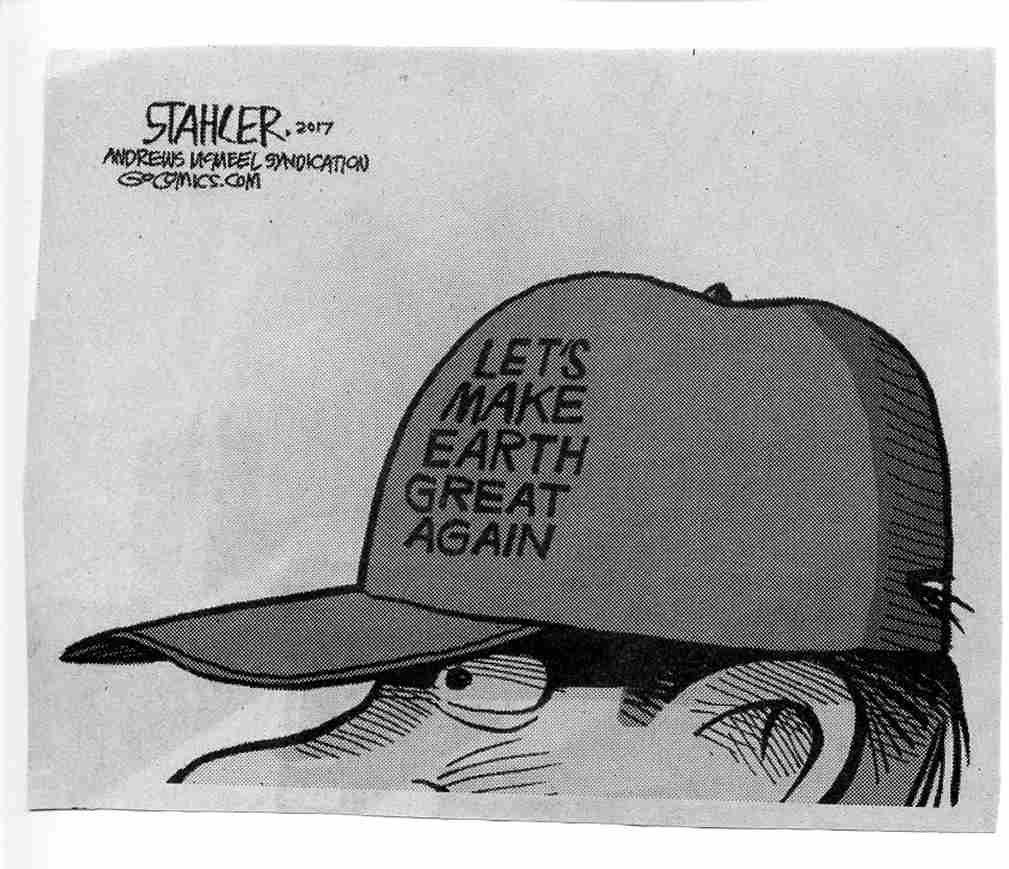
MEGA - Make Eaarth Great Again
(Click the image for the full-size image)
|
|---|
|

|
|---|
republican plan - hate and blame the other
(Click the image for the full-size image)
|
|---|
|
"What luck for the rulers that
men do not think". - Adolph Hitler

|
|---|
voting against their own interests, again
(Click the image for the answer)
|
|---|
|
.

|
|---|
better than trickle down, up yours
(Click the image for the answer)
|
|---|
|
.

|
|---|
worthless thoughts and prayers
(Click the image for the full-size image)
|
|---|
|

|
|---|
may the Forest be with you
(Click the image for the full-size image)
|
|---|
|