East to West below the Mogollon Rim, Arizona
by Rob Jones, Wild Vagabond
June 6 - 11, 2020
53.7 miles; ERM = 93.8
Text © copyright by Rob; and Photos © copyright by Rob Jones

|
Haughty Highline Trail Traverse:
East to West below the Mogollon Rim, Arizona by Rob Jones, Wild Vagabond June 6 - 11, 2020 53.7 miles; ERM = 93.8 Text © copyright by Rob; and Photos © copyright by Rob Jones |
|
Total = 53.7 miles, with an ERM = 93.8
Co-adventurer - Solo adventure; assistance by Barry Brenneman and Patrick Fuchs
Camera - photos from the S-10 Smartass (sadly, the Panasonic ZS-60 died during the Rock Art Rhapsody Cruise)
Note: haughty as in high; elevated. Lofty; bold; adventurous.
|
| |||||
|
| |||||
|
| |||||
|
| |||||
.
Overview:This is a report about a solo jaunt, hiking the Highline Trail
in Arizona. Starting on the East end of this trail, I hiked West below the Mogollon Rim, near the 6,000' elevation level
for most of the hike.
ERM = Energy Required Miles. A mile is added for
every 500' elevation gain or
loss. It's a very serviceable method of estimating energy required miles. ERM was initially used in Trails
of the Tetons (long out of print) by Paul Petzold, founder of NOLS. It's a wonderfully useful concept and
application. Add one mile for each 500' up AND down to distance = ERM. I use ERMs to calculate what the actual
day is like. It's a very serviceable method of estimating energy required miles. Remember, however, that the
ERMs are estimates because they depend on GPS satellite coverage and math functions.
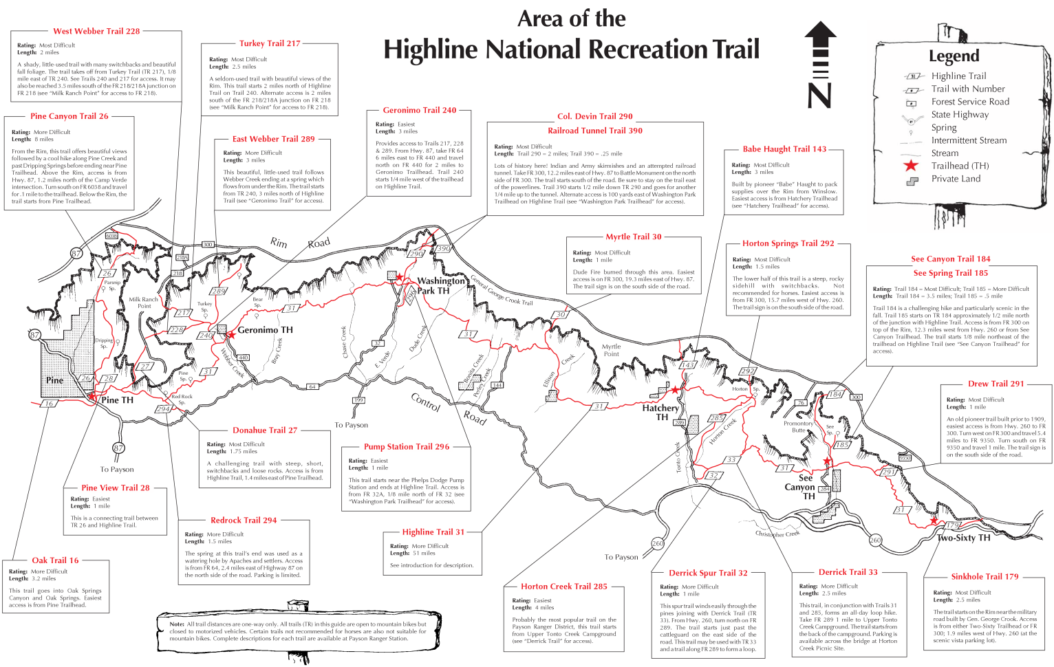
Background: The Highline National Recreation Trail is an approximately
57-mile, or so, trail that runs below the Mogollon Rim in the Tonto National Forest in Arizona. It's distance is changing because
of ongoing trail rerouting. My mapping program arrived at a distance of less than this because of track discrepancies (53.7
miles), and a cumulative elevation gain of 9200', loss of 10,500'. The trail features vistas of rim canyons, brushy hills, distant
mountains, unique rock formations, and wonderful stands of Ponderosa pine, P-pines. The trail was established in 1870 and
was used to travel between homesteads and to attend school in Pine, Arizona. Zane Grey and Babe Haught used the Highline
Trail while hunting. The Highline was designated as the Highline National Recreation Trail in 1979 and has become
predominantly a hiking trail.
Geology of the Mogollon Rim
by Wayne Ranney: With the exception of the Grand Canyon, no other physical feature of Arizona’s landscape
is more prominent than the Mogollon Rim. Five of the six National Forest in Arizona contain or border this spectacular escarpment
(the only exception is the Coronado).
Geology of the Mogollon Highlands - USGS: Link to the USGS article about the
geology of the Mogollon Highlands.
Click here for the USGS report (pdf).
Using ERMs does not account for the 'texture' of the route or trail - that
is, rocky, boulders, no trail, slimy mud, etc., yet does help approximate the route.
See more information about ERMs at the end of this report.
The Western portion of the Highline Trail from the Washington Park Trailhead to the Pine
Trailhead is part of the Arizona Trail - passage 26. Sections of the trail have been burned multiple times, including by the deadly
Dude Fire in 1990, and the Highline fire in 2017, where part of the trail was used as a firebreak. This opened the canopy of glorious
P-pines, producing hotter hiking conditions. The Eastern part of the trail underwent significant maintenance and improvement
between 2012 and 2018. The trail is still evolving. Volunteers of Outdoor Arizona have worked on segments of the trail, http://www.voaz.org/
It's been a chore trying to find water reports about the Eastern portion of the Highline Trail.
I talk with a helpful woman at the Tonto NF and Patrick F., who previously hiked the trail. This helps. The segment of the trail West of
Washington Park/East Verde River receives occasional water report updates via the AZT, Arizona Trail, app and these reports are more
current than what can be found about the Eastern portion of the HT.
My mapping program totaled this hike as 53.7 miles, with an ERM = 93.8. The HT distance is
no doubt longer than 54 miles because of ongoing rerouting of the trail. Explanation: The mileage and elevation gain/loss are from
my gaia mapping program. Gaia has a current, yet perhaps not the most current track and I used it. In good battery times, I'd track
this myself and obtain on the ground info.
But what is the Mogollon Rim? How did it form and when? The answers are only now
becoming clearer as earth scientists complete detailed studies within Arizona’s Transition Zone Province, that area between
the Colorado Plateau to the north, and the Basin and Range to the South. The Mogollon Rim lies in the heart of the Transition
Zone and has undergone a fascinating evolutionary history.
The Mogollon Rim is a high, forested escarpment, or line of cliffs that stretch almost
continuously from Seligman, AZ to the Arizona-New Mexico state line. The heart of the Mogollon Rim goes from the small
town of Strawberry to the developing communities of Pinetop-Lakeside. The name may have been derived from that of the
colonial governor of Spanish New Mexico, Juan Ignacio Flores Mogollon, who administered these frontier lands between
1712 and 1715.
Geologically, the Rim has been forming since at least 35 million years ago. Its story
begins with the birth of the Rocky Mountains, when a mountain range was uplifted in central Arizona. Geologists call this
now-eroded uplift the Mogollon Highlands after the escarpment they help create. When the Mogollon Highlands were
uplifted, the sedimentary layers which make up the rim were tilted down to the northeast. And this tilted stack of sediments,
which are most spectacularly exposed in the Sedona area, have been eroding (retreating) to the northeast ever since. House
Mountain, which is a shield volcano located southeast of Sedona in the Coconino National Forest, erupted between 15 and
13 million years ago at the very base of the ancestral Mogollon Rim. The distance can be traced from the edge of the lava
flows to the present-day Rim and determine that the Rim has been retreating at the rate of one foot every 625 years. At
this rate, which is only an average, the colorful cliffs north of Sedona will erode back to downtown Flagstaff in another
79 million years!
This escarpment, which provides Arizonans with a multitude of recreational
opportunities and scenic vistas, is now being eyed by the thirsty desert cities to the south for its valuable water
resources. The citizens of Arizona will be the ones who decide whether these resources are best utilized for continued
urban growth or for a myriad of recreational pursuits. An informed educated public can best decide the wisest course
of the Mogollon Rim’s future management.

| ||||
Another version of the map can be found here.
This version can be enlarged and may be more useful than the above map ----> click here.
Day 1 photos, Highline Trail


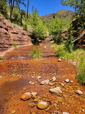
Day 1: Hit the Beach. Hwy 260 TH to See/Christopher Canyon
6.7 miles, ERM = 11. Camp @ 6400'.
I meet Barry B. for an early morning shuttle to the hwy260 TH, dropping the
Subie Subaru at the Pine TH along the way to the 260.
While dropping off the rim, a velvet antlered Elk jumps into the road ahead of
us. Sleek and tawny, I wonder if his bachelor buddy herd is right behind, which will require evasive maneuvers.
Barry and Lucy the Border Collie and I walk the groomed trail over patches of
reddish sandstone slickrock (Supai Formation), the grade pleasant to the Drew Canyon Trail, which climbs to the rim,
up through ocean-deposited Kaibab Limestone. Old beaches and petrified sand dunes, as described in this USGS publication
provide the footing for today's hike
Click here for the USGS report (pdf).. Ancient beachfront property.
Today, 75 years ago (June 6th, 1944), the allies hit the beach of Normandy to
rid the world of the horrible authoritarian of that era, Hitler. Currently, we have another destructive despicable narcissistic
authoritarian despot using the same Hitler playbook, t-rump, the orange clown pufferfish. The entire world is suffering
under the carnage wrought by this yuge selfish monster. Destroying health and planetary wellbeing, ushering in a plague
(EtV, Evil trump Virus; COVID-19, no effort to stop or treat it) and a freewheeling economic and social depression, the cheeto only thinks of
himself and how to blame others for his deliberate nasty acts that harm people and the Eaarth, and his refusal to act
when needed. It's good to be on the trail and away from the constant barrage of horrid news about what t-rump has
done or refused to do.
Where the HT, Highline Trail, crosses the Drew Trail, we enjoy a snack and then
Barry and Lucy head back to the 260 TH and I continue on in the mixed forest of P-pines, Douglas Fir, Alligator Juniper,
Manzańita, oaks and such. There's a break to cooler weather over the next few days, yet it's still plenty hot in the open areas.
I stop in the shade of a maple, alongside a clear trickle of water, filter a liter and
enjoy the Columbine swaying in the breeze.
Then, to See Canyon/Christopher Creek, where there's a noisy clog of people who
have apparently hiked up from a nearby TH to frolic in the cool water.
It's too late to continue to the next known water, so I relax in the shade of a fir and
soak in the sweet smell of flowering Manzańita along with the vanilla goodness of heated P-pines.
There's a maelstrom of propagation, noise, trash, and activity around See Creek and
I look in vain for a camping nook. We have no chance of extracting ourselves from this climate mess unless the human population
declines, significantly, and we have a more responsible government. I believe that a pandemic or maltreatment is not an humane
or economic way to reduce the population of the Eaarth, but repulsicans apparently disagree, blocking access to affordable
health care (birth control), privatizing education, trying to eliminate planned parenthood, widening income disparity, doing
nothing to deal with the EtV (Evil trump Virus).
New, old, and social trails are everywhere flat. So, I load up with water and inch up the
trail West to the next ridge where it's quiet. Not bad but gusts of wind sweep the flattish section. I figure that the wind will die
toward sunset, so I set up camp and gaze at the tree studded rim and my neighbors, the Alligator Junipers.
| ||||
| ||||
 |
 |
 |
 |
 |
 |
 |
 |
 |
 |
 |
 |
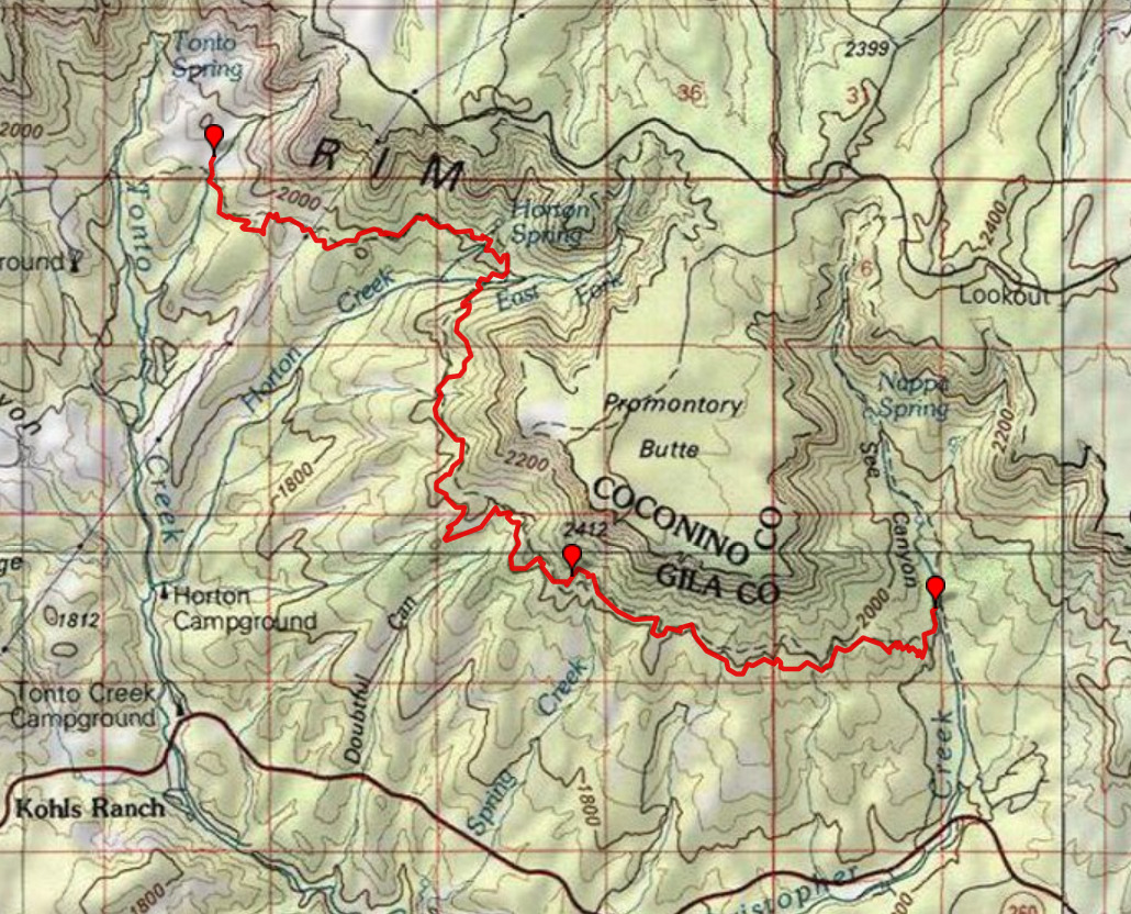
Day 2: Horton says "Who?" To Dick Williams Creek
10.8 miles, ERM = 20. Camp @ 6250'.
It's a crisp morning, I note, as the full moon glows through one flank of the
TarpTent Notch and the early origin of sun brightens through the open door on the other side. Excellent bookmarks.
I lilt along the early morning trail when I see Coatí Mundî tracks in the dirt.
Alas, no Coatí do I see. When I stop for the first break on the salmon sandstone, a kettle of Turkey Vultures forms
over me. Not yet being trail seasoned, I assume it's because of the thermals and not me.
Turkey Vultures are among the few birds that have a sense of smell. They
have been used to locate natural gas leaks in pipelines traversing fields. Could they smell me, reeling in their kettle?
Naw, it's too early in the adventure.
The trail continues, quietly and serene. Suddenly, there are Bufous Bear
tracks in the trail. There's a feeling of wildness here, punctuated by the roving Bear tracks. And it stays this way to
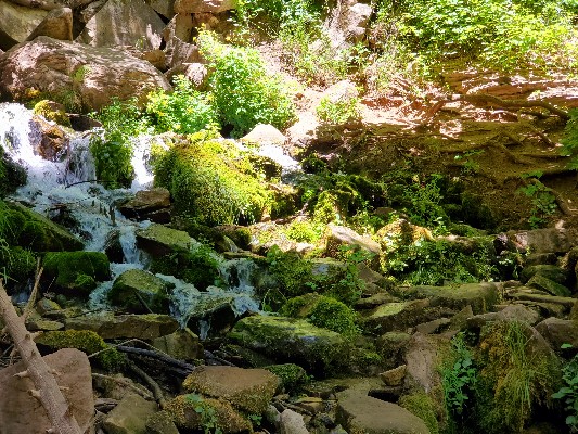
near Horton Spring. The East Fork is dry, yet there's a convention where the HT meets the Horton Creek Trail, with
numerous people making the 9-mile loop of the Horton forks. And, I soon see how come. Water gushes from the hillside,
clear and crisp, feeding yellow Monkey Flowers and Columbine. I talk over lunch with two young women who are hiking the
loop. I initially thought that I might camp in the area, but the crowd and the mutilated ground convinces me to move on
down the trail. In addition, it doesn't smell right here, a probable consequence of the high use. Besides, it's still early in
the day and the brisk breeze and below torrid temperatures make the final decision. I later learn that camping is closed in
the Horton area because of the presence of nesting Spotted Owls.
As soon as I leave the HT-Horton intersection, the calm spirit of the trail returns and
endures until I roll into the clear burbler of the Dick Williams riparian area. Here, the song of the water elevates the spirit of
the trail. Elk and horse tracks dominate this section. Finding a bench camp on a reasonable slant, I call it home, not wanting
to continue to the TH area near the Tonto Fish Hatchery, along, of course, Tonto Creek.
The wind continues into the evening and is surprisingly cool, and I'm wearing wool t-shirt,
hoody, and down jacket by dinner, despite being nestled in a Manzańita windbreaker nook.
| ||||
Another version of the map can be found here.
This version can be enlarged and may be more useful than the above map ----> click here.
Day 3 photos, Highline Trail


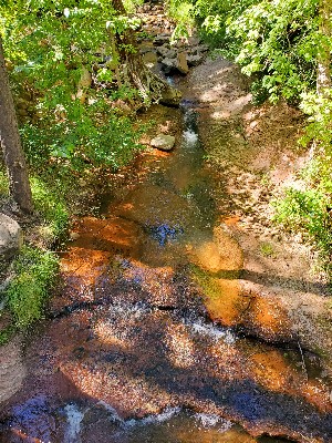
Day 3: Deafening Natural Quiet. To Ellison Creek
8.3 miles, ERM = 13.7. Camp @ 6350'.
Elk cows murmur to their calves in the early evening. Sweet and low eeking and Elk mutterings.
Later, the Song Dog yips and yowls, not far from my tent, and awakening me from
delightful dreams. This is precious. Until she continues for what must be 10 minutes or more. I talk with her, but apparently
she is seeking someone else. Eventually, others reply from across the basin and I hear her trot off, staccato paw falls clearly heard.
Its cool enough this morning that cradling the hot mocha mix between hands and thighs
feels just right as the neighborhood woodpeckers or sapsuckers begin drumming.
Tonto Creek is flowing in the background as I fiddle with the newly dead solar panel. It's
been a reliable panel and its demise is not good.
I note that there is a campsite available on the old road before getting to the fish hatchery
road and TH. I cross the road and read the info in the trail register, where I learn that the area around Horton Creek is closed
because of Spotted Owls.
The trail rises to and stays in the Supai Formation slickrock. I'm thrilled because the Supai
is the 5th layer down in The Canyon, Grand Canyon. It feels a bit like walking home. Ahhh. The West Fk Tonto is fading. This stream
may be dry soon. Besides, it appears to be on private land.
Elk rule the trail. I don't see other tracks. The saunter across slickrock and through old
fire area provides great views but I'm guessing it's too open if hot.
Taking photos of Myrtle Point and Lupine pause the hike.
Now into a burned area with a free-dumb rider firebreak erosion ditch, which improves,
then doesn't. With every incline there's an ankle-twisting jumble of fractured sandstone. Free-dumb riders appear to have found
a way to get up on the old trail badly bladed into a fire break. Sigh.
No water at Big Creek.
The going is often slow, yet at the bottom of an erosion slump into a canyon I am delighted
to see trickling water from La Ciénega Spring/E Fk Ellison. Yahoo. So, a respite under an Arizona Walnut is required to sip a liter
and enjoy lunch #2. With all this open country, it's excellent to have a cool day and a gusting wind. It's almost cold in the deep shade.
Solar panel is definitely not working, argh.
I press on to Ellison Creek. More aptly Ellison trickle. It's a disintegrating trail due to fire
damage, extensive erosion, and neglect. No wonder I don't see anyone today. I have to search far up trail for a level, somewhat
sheltered (from the cool wind) camp. Noting the uncertainty of water until Washington Park, I opt for a bath and laundry day.
| ||||
| ||||
 |
 |
 |
 |
 |
 |
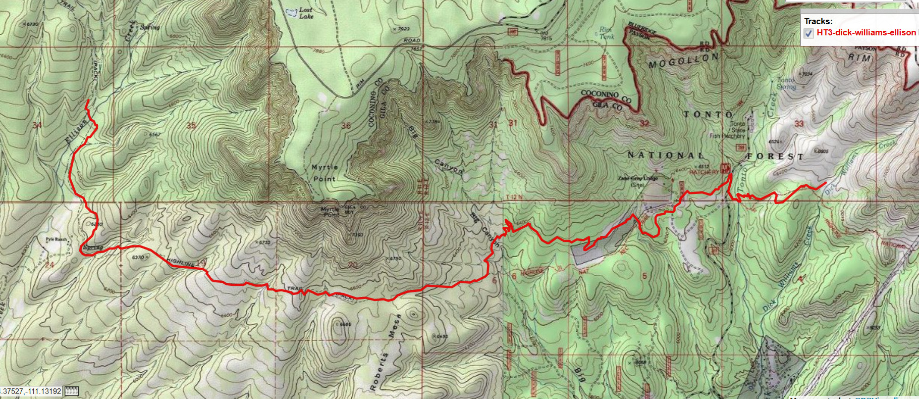
Day 4: Blown to Hells Gate, or Your Dudeness Awaits. Dust in your teeth. To
East Verde River/Washington Park
10.3 miles, ERM = 17.5. Camp @ 6050'.
Finally, I'm nestled in the cleft of dry Perley Creek for a late breakfast. The torrent of
wind rages above, whipping trees like pompoms.
I awake to the tent pressing down on my face. The whole tent is angled downwind
after a peg is pulled in the nighttime gale. My sleeping pad is holding the works in place, sort of. It's a miserable windblown
morning. Sounding like a locomotive, the gusts churn wildly down and across the drainage. I'm cold, there's no way I want
to cook, so I start hiking.
I sing that song "Dust in your Teeth," all you have is dust in your teeth. .... and so it goes.
(Sung to the tune "Dust in the Wind" by Kansas.)
The quality of trail is poor, with significant erosion and rocky texture and topography.
The trail dives into Hells Gate and I'm soon off trail. Yes, the rocky trail plunges into the Hells Gate drainage, then disappears.
Aptly named, it's like a gateway to hell, except that it's quite cold this morning. I find a tread and soon realize that it's the old trail.
Eventually, I cut cross-country and I'm back on the trail.
After Perley, there's an excellent enjoyable trail. This excellence lasts to where the HT
begins to overlap the AZT, Arizona Trail at the East Verde, the Washington Park TH. Wonderful. And my clothing assortment is
down to two layers from the four with which I started. Now the wind whistles mildly (relative to the morning hurricane)
through the ghost trees.
Bonitá Creek is flowing pure, with decent camping, a ribbon edge of green in the burn
zone. I would have camped here if I was sure about the water.
The sweetly revised trail continues to ramble the contours through a previously burned
area, arriving at the main fork of Dude just in time for lunch #2. A gorgeous cascade of cold water ripples over red sandstone,
forming a picturesque place for contemplation. To add to the magic of Dudeness, I realize that I haven't seen anyone since Dick
Williams. Dude! Communing with the aura of Dudeness, I invest nearly an hour lounging under a huge Douglas Fir and relishing
the Dude Creek burble. So much better than the cow burnt lands of the Easterly fork of Dude. To camp, one will be best advised
to tank up with water and hike West about 0.5 to 1 mile, out of the burn and into the trees and flat terrain.
The trail tours the contour of a red sandstone layer mostly until reaching the East Fork
Verde, a pretty noisy place at times, especially on weekends because of the mob of visitors.
Today, it's fairly quiet at the Washington Park TH. I look for some time for a camp outside
the closed zone. Lots of hillside means poor camping.
I note that there's a new AZT, Arizona Trail, bridge over the East Verde and say thanks to
fellow VIP (Volunteer In Park) Roger Smith and the Arizona Trail crew that installed this elegant span. Thanks Roger!
Finally, I locate a spot overlooking the East Verde and set up camp as the sun drops. Cool
water cascades below, providing natural quiet. It feels like a lovely and calm evening.
| ||||
| ||||
Another version of the map can be found here.
This version can be enlarged and may be more useful than the above map ----> click here.
Day 5 photos, Highline Trail


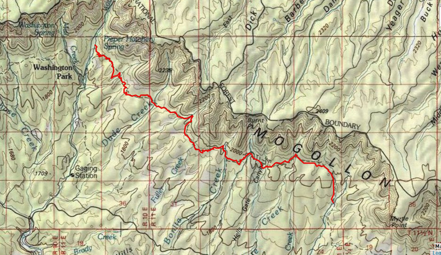
Day 5: Braying with Bîggly Bear. To Webber Creek/Geronimo TH
9 miles; ERM = 16. Camp @ 5450'.
After yesterday's good beating, I sleep in later than planned. The cool weather
wave is predicted to end today, and I thought an early start would be good. Last night was warm and this morning has only
a hint of coolness. Oh oh.
It's a quiet trail this morning and I follow the tracks of Bîggly Mother Bear and her
kin cubs off and on to Bray Creek. Braying with Bîggly Bear? It appears that they were out patrolling the trail last night
because their tracks are ubiquitous, and fresh.
Undulation may be the word for today, along with Bîggly, because the HT-AZT rolls
and undulates through numerous drainages, some with glorious water and others as desiccated as trump's thought processes.
Zpaw and Mr. P. come along, hiking the AZT, and we enjoy a good discussion.
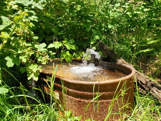
There's a spectacular bubbling gusher at the Bray Spring horse trough, about 0.14
miles below the trail. There's a frail dribble from the small pipe alongside the trail. The lower source is better. My legs
notice that there are stickery wild raspberries galore, albeit not yet ready to eat. Bray is an excellent place for a long snack break.
After the Bray break, it's umbrella time and the stopping in the shade is more
frequent. A mature maple provides restoration shade at Bear Spring, which sports a low flow of water. True to its moniker,
there's a Bîggly Bear track in the mud near Bear Spring.
The first two cow Elk crash away before I have any idea they are nearby. I see the
third in another mile or so before she runs and I try to shuffle to within camera range. Too many trees and a semi-cautious
Elk. She clatters into the P-pines.
I meet 3 women, one from Idaho and two from Flagstaff, hiking from Happy Jack
to Pine on the AZT. They decline my request to take a photo, so there is no photo.
Soon, the Geronimo TH and Webber Creek appear and I locate a camp on the West
bench above the stream. The stream and camp are bordered with basalt, a first that I recall on this jaunt.
It's definitely warm enough for a bucket bath (far away from the stream) which helps
remove a pound of salt and 8 ounces of dirt. Ahhh.
Including breakfast, I've downed a gallon of water today, some with the poor hiker's
electrolyte, salt. And there's a liter of red miso with dinner. Irrigate, Irrigate, the motto of the HT.
| ||||
| ||||
| ||||
 |
 |
 |
 |
 |
 |
 |
 |
 |
 |
 |
 |
Day 6: Haughty Highline Heat. To the Pine Trailhead
8.6 miles, ERM = 15.6.
Total HT miles = 53.7 miles, with an ERM = 93.8.
Morning Elk utterances wake me to Day 6. I'm on the HT early and wow,
it's hot already and not even 6:30 a.m.
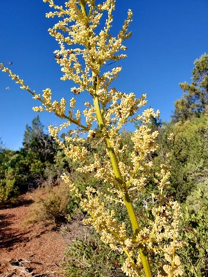
The bees are having an excellent day. There's a Bear Grass buzby video to
illustrate this. Lovely.
Pausing in deep shade at defunct mud bog called Pine Spring, it takes a few
minutes for my internal temperature to lower to close to normal. A tortillá with a thick coating of nütella and a half
liter of peăch mangó green tea with a pinch of salt revives me for the next section of baked trail. All enjoyed under
the saving shade of a deluxe P-pine.
Continuing on, it's not far to Red Bank Spring, where the view ranges to the
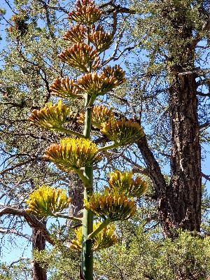
Matazal Wilderness and Mountains. A huge flowering Agave has been toppled, perhaps by the relatives of Bîggly Bear,
and either a small species of bees or of some sort of fly are frolicking among the blossoms.
I'm starting to wonder when the fabled downhill to the Pine TH might begin. I
recall a long uphill when hiking these parts on the AZT, so where is the downhill? The trail enters the land of Pinyőn Pine
and Arizona Cypress. This is the first area where I recall seeing Cypress on the HT. And, speaking of cypress, a gracious
grove of Arizona Cypress provide shade for a long break.
Andrew comes lilting along, as if he hadn't climbed up from Pine. photo
A most excellent discussion is enjoyed with Andrew, ranging from the wily Bîggly
Bear to the Arizona Cypress and Alligator Juniper. And, of course water sources. Andrew is hiking the AZT-HT to Horton
and then up onto the Mogollon Rim.
There really is no fabled downhill. It is downhill, yet well-graded. The downward
decline dawdles downhill to the Pine Trailhead, ending in a clump of heat at the conclusion of the Haughty Highline
Traverse Hike.
| ||||
*ERM: Energy Required Miles, are there data to support this
mileage adjustment?
Journal of Outdoor Recreation, Education and Leadership
Petzoldt first proposed his theory in his 1976 book "Teton Trails" to
help backpackers plan trips and calculate their energy needs on mountain trails. "Petzoldt defined one
energy mile as the energy required to walk one mile on the flat. He recommended adding two energy miles
for every 1,000 feet of elevation gain, so a person hiking one mile and 1,000 feet upward would use the
equivalent of three energy miles," Phipps said.
Petzoldt's energy mile theory was just a reflection of the mountaineer's
"gut feeling," Phipps said. The theory had never been tested in a laboratory before the study began in WCU's
Exercise Physiology Laboratory in the spring of 2010, Phipps said.
To determine the validity of the theory, the study measured the energy cost
and perceived exertion for walking on flat ground, with and without a 44.5-pound backpack, and up an elevation
gain of 1,000 feet, with and without the backpack, through the collection of metabolic data, Phipps said.
Twenty-four student, faculty and staff volunteers, including 12 males and 12
females, went through four testing sessions as the research continued into fall semester of 2010. The study
results showed that the additional energy cost for ascending 1,000 feet ranged from 1.34 to 2.02 energy mile
equivalents, for an average of about 1.6 miles, compared to Petzoldt's use of two energy miles for each 1,000
feet. The range revealed by the study was due to the "hikers' personal weight differences," Phipps said. "It is
remarkable that Petzoldt's energy mile theory is so close to the actual energy cost measured during our
study," Phipps said. "In the field of outdoor education, it's important for leaders to include an estimation
of energy requirements during the planning of hiking trips."
Phipps said the energy required for hiking up steep mountain trails would vary
for individuals and groups, and the variables of the trail would also factor in, but he recommends that
backpackers stick with Petzoldt's idea of adding two energy miles for every 1,000 feet of elevation gain when
planning trips.
The Validity of Petzoldt's Energy Mile Theory, 2010
Authors: Maridy McNeff Troy, Maurice L. Phipps
Publication: Journal of Outdoor Recreation, Education, and Leadership
| ||||
| ||||
| ||||
| ||||
.
Let's look at what one conservative columnist had to say about the EtV...........
This Is Trump’s Plague Now: by David Frum,
Staff writer at The Atlantic /Getty / The Atlantic, Mon. 29 June 2020 COVID-19 infections peaked on April 24, or so Americans assumed. State health authorities
reported 36,738 new cases that day, a record. By mid-May, the US had reduced that rate of infection by nearly half, to 17,618 on May
11. The accomplishment had come at a tremendous cost: the lockdown of much of the national economy, Great Depression levels
of unemployment, the shift to online schooling for millions of children, families denied final visits to dying loved ones. Still, these
sacrifices had delivered the desired result. Had that progress continued, the American people—and the American economy—could
have likely foreseen a further decline in cases and perhaps a near end to the pandemic, even before a vaccine.
But that’s not what happened. On June 24, the number of infections surpassed the April 24
peak. On June 25, the number surpassed that of June 24. On June 26, the country suffered almost 46,000 new infections—nearly
10,000 more in one day than on the worst day in April. All of the sacrifices of the past weeks have been thrown away.
The first coronavirus spike, in late April, can be blamed on President Donald Trump’s
negligence. The second spike, in June, is his own doing. This is Trump’s plague now.
A Washington Post report on June 27 captures Trump’s culpability with horrible aptness.
The city of Tulsa, Oklahoma, has been enforcing social-distancing rules, and for good reason. From June 1 to June 15, new COVID-19
cases in the state jumped from 67 in a day to 186. In advance of Trump’s rally in Tulsa on June 20, city employees affixed Do Not
Sit Here Please stickers to every other seat in the stadium venue. Trump campaign workers were captured on video removing the
stickers so that Trump could cram attendees closer together. On June 26, Oklahoma reported 396 new infections in a single day.
Trump’s rally may not directly account for all those new cases. But Trump’s elevation of the
needs of his own ego over the well-being of even his strongest supporters is profoundly implicated in the virus’s powerful June comeback.
Even before the viral peak on April 24, Trump urged the reopening of the US economy. On
April 16, Trump convened the nation’s governors by conference call to press them to lift restrictions by May 1. The White House
that day also released a set of highly permissive guidelines to inform the process, recommending a three-phased plan to begin after
states had established a 14-day “downward trajectory of documented cases.” But how steep a decline? Many decisions were left
to the governors, at least ostensibly.
“You’re going to call your own shots,” Trump told the governors on the call. “You’re going to be calling the shots. We’ll be standing
right along-side of you, and we’re going to get our country open and get it working. People want to get working.”
At the time, this show of deference to the governors looked like a political retreat by the
president. Days earlier, Trump had declared that he alone had “total authority” to reopen the economy—and it would be “the
biggest decision I’ve ever had to make.” But the deference soon proved a sham. Trump was set on the widest and earliest possible
opening, and he exerted the immense political power of his office to get his wish.
In mid-April, protesters—many of them openly brandishing weapons—assembled at the
capitols of Democratic-governed states to demand immediate reopening. Trump tweeted his support. “LIBERATE MINNESOTA!”
“LIBERATE MICHIGAN!” “LIBERATE VIRGINIA, and save your great 2nd Amendment. It is under siege!”
At first, Fox News hosts and guests had dismissed COVID-19 as a Democratic plot against the
Trump economy. Just one example of many: On March 9, Sean Hannity said, “They’re scaring the living hell out of people. And I see
them again as like, ‘Oh, okay, let’s bludgeon Trump with this new hoax.’” Then, in mid-March, the network abruptly switched its
editorial line. Hosts not only voiced concern, but adamantly denied that they had ever done otherwise. “This program has always
taken the coronavirus seriously, and we’ve never called the virus a hoax,” Hannity said on March 18.
On April 29, Florida Governor Ron DeSantis appeared on the Hannity program to tout his
state’s triumph over the virus. “We know who the vulnerable populations are. We know, if you look at the statistics for people
under 50 who don’t have chronic conditions, I mean, you have an extremely low chance of death from this virus and those situations.
We know how to protect folks and social distance between those two groups, and so I think there’s a lot of things we’ve learned over
the last six weeks. So I think we can take a step forward here in May, continue to build on that, and get America back.”
On May 3, Trump staged his notorious town hall in the Lincoln Memorial—a site usually forbidden
to be used for partisan purposes, but accessed by Trump via a special exemption. Trump used the occasion to exhort governors to
reopen even faster than the guidelines had laid out. “There’s not too many states that I know of that are going up. Almost everybody
is headed in the right direction,” he said. “We’re on the right side of it, but we want to keep it that way, but we also want to get back
to work.” He praised states that were moving quickly to reopen their economies—and singled out Virginia as a state that was moving
too slowly.
By this time, Republican-led states had begun letting their stay-at-home orders lapse, starting
with Georgia on April 23. Trump initially praised the Georgia plan, then criticized it—but ultimately approved it. Texas followed on May
1. Florida launched the first phase of its reopening on May 4.
Trump promised vaccines by the end of the year, and a surging economy by the third quarter
of 2020. And if anything contradicted all this happy talk, the president had his answer ready. “The only reason the US has reported
one million cases of CoronaVirus is that our Testing is sooo much better than any other country in the World,” Trump tweeted on April
29. “Other countries are way behind us in Testing, and therefore show far fewer cases!”
As Trump had hoped, good news began to arrive in the early part of May. Cases were trending
down, as were deaths. On May 11, he tweeted: “Coronavirus numbers are looking MUCH better, going down almost everywhere. Big
progress being made!” Trump ran another victory lap on May 17. “Doing REALLY well, medically, on solving the CoronaVirus situation
(Plague!). It will happen!” That same day he added: “The number of Coronavirus cases is strongly trending downward throughout the
US, with few exceptions. Very good news, indeed!” That was fateful timing. The COVID-19 news from mid-May on would almost all be bad.
What went wrong? Early reopening could only have worked if stringent safety measures,
including the use of face masks and social distancing, were incorporated. Yet the president sabotaged the reopening he himself had
forced. Throughout his presidency, Trump has subordinated rational policy in order to provoke virulent culture wars. And the mask
has become a rallying symbol for his supporters.
Trump never wears a mask in public, and he has mocked Joe Biden for wearing one. “I see
Biden. It’s like his whole face is covered. It’s like he put a knapsack over his face. He probably likes it that way,” Trump told The Wall
St. Journal on May 21. The Journal’s Michael C. Bender then followed up. He remarked that Trump often negatively commented on
masks, especially when worn by White House reporters. “Do you view that as a protest of you? Do you feel like people wear masks
to show their disapproval of you?” Trump allowed that it could be—then attacked the health hazards of masks—then expressed
indifference whether his supporters wore them or not.
Rush Limbaugh mocked the mask as a “symbol of fear” on May 15. The former Fox anchor
Brit Hume joined in. On May 27, a writer at the pro-Trump web publication The Federalist posted a piece headlined, “Mandatory
Masks Aren’t About Safety, They’re About Social Control.” The author, Molly McCann, warned: “If everyone is wearing a mask, it
telegraphs a society-wide acceptance that the status quo has changed.” That morning, a pro-Trump writer named Lee Smith tweeted
a link to the article, amplifying McCann’s paranoia. “Terrific @molmccann piece in @FDRLST — masks aren’t about public health but
social control. Image of Biden in black mask endorses culture of silence, slavery, and social death.” Smith is a major figure in the
pro-Trump media landscape. Formerly a Middle East correspondent for Bill Kristol’s Weekly Standard—and still connected to the
eminently mainstream Hudson Institute—he has plunged deep and thick into the pro-Trump cause. In the early morning of May
28, Smith’s tweet got a retweet from Trump himself.
You might not imagine that there would be much room to escalate anti-mask rhetoric from
“silence, slavery, and social death.” You would be wrong. An Arizona city councilman derisively appropriated George Floyd’s dying
words, “I can’t breathe,” to mock mask-wearing. Sebastian Gorka, a former Trump adviser, found a way to go even further than
that on his June 23 radio program.
Millions of citizens obeyed the cues from Trump, the right-wing media, and the medical crackpots
who predominate Facebook. While the great majority of Americans approve of mask wearing in public, only 40% of Republicans do. On
June 20, a short video showed up on Twitter of a middle-aged man in shorts trying to enter a Florida Walmart unmasked. When a
masked store employee politely reminded the customer of store rules, the man shoved the employee so hard that the shover actually
fell over from his own momentum. The customer got up and pushed the same employee again to force his way in. Perhaps the customer
was carrying one of the fake “anti-mask exemption cards” now circulating on the internet and social media for printing at home.
As the US nears the 4th of July, the disease is reviving. Some Trump supporters want to blame
the Black Lives Matter protests for the spike. But the states that mounted the largest protests have seen caseloads decline since George
Floyd’s death. Minnesota reported 645 new cases on May 26, then 493 on June 26. New York recorded 1,044, then 804 on the same
dates. Washington, D.C.’s 109 cases on May 26 fell to 26 by June 26. Granted, not everybody who protested in those places lived in those
places, so perhaps some demonstrators carried the virus to other states. But there’s certainly no obvious link yet. Meanwhile, JPMorgan
has found powerful connections between rising restaurant spending and, 3 weeks later, increasing COVID-19 infections.
The disease is spiking in places precisely where state governments hastened to reopen bars,
casinos, restaurants, shopping malls, and other indoor places of entertainment. Phoenix, Houston, and other southern cities are suddenly
reporting caseloads that look like New York City at its worst. Florida reported nearly 9,000 new infections on June 26, nearly equaling
some of New York’s worst days. Texas recorded almost 6,000 new cases that day. Arizona reported nearly 3,400 new cases on June 26
and now suffers more cases per capita than Brazil or any country in Europe.
In the face of this worsening crisis, Trump is not taking action; he’s instead shifting the goalposts:
Don’t pay attention to the case rate, he now argues. Look at the death rate. Last week, he tweeted: “Coronavirus deaths are way down.
Mortality rate is one of the lowest in the World. Our Economy is roaring back and will NOT be shut down. ‘Embers’ or flare ups will be put
out, as necessary!” But deaths lag behind infections, and a rise in cases in late June warns of more deaths to come in late July. We’re already
well past the death toll of 100,000 that Trump predicted at his Lincoln Memorial town hall only eight weeks ago.
Trump’s hopes for a third-quarter economic recovery are also blighted. Spending data suggest that
the upward trajectory of May and early June has halted and reversed in the states that have opened. The slight uptick in employment in
May now may prove abortive. For millions of American families, the hardest reckoning arrives on July 31, when the federal government
stops supplementing state unemployment insurance benefits. Those who have kept their jobs face other hardships. Will schools reopen
in September? It looks more and more doubtful.
At the onset, the pandemic was aggravated by Trump’s negligence and indifference. He had
dismantled the country’s pandemic preparedness. He denied the disease for two months. He made one crucial mistake after another.
Even so, Trump could plausibly shift at least some blame for the arrival of the disease. The
pandemic did originate outside of the US, China did cover up the disease, and the World Health Organization did enable China. Trump
could also argue that even those countries with the best responses were hit hard for many weeks.
But what has happened in the US in June, and what will happen in July, is entirely Trump’s fault.
The president’s approach to the virus has been guided by his lifelong beliefs: It’s just as real to say you have done a good job as to do a
good job. Denying you failed is just as real as actually succeeding. This time, though, reality will not be blustered away. Tens of thousands
are dead, and millions are out of work, all because Trump could not and would not do the job of disease control—a job that includes
setting a positive example to those Americans who trust and follow his leadership.
David Frum is a staff writer at The Atlantic and the author of Trumpocalypse: Restoring
American Democracy (2020). In 2001 and 2002, he was a speechwriter for President George W. Bush.
.
The first coronavirus spike, in late April,
can be blamed on the president’s negligence. The second spike, in June, is his own doing.
From mid- to late April, the trajectory of infections in states such as Georgia, Florida,
and Texas was relatively flat, not down.
Despite that, Trump cheered for governors to reopen fast and faster. On April 29, Trump declared that federal social-distancing
guidelines would be “fading out.” “I’m very much in favor of what they’re doing,” Trump said in the Oval Office about the southern
and western governors who were racing to reopen by May 1. The governors were responding to political pressures from local business
owners, yes. But they were also obeying the president’s wishes and yielding to pressure from right-wing media.
But as Trump pressed for reopening, the Fox News line shifted again. Hosts and guests
tumbled over one another to demand more
reopenings, faster, bigger—and to pooh-pooh any continuing danger from coronavirus. “The virus just isn’t nearly as deadly as we
thought it was, all of us, including on this show. Everybody thought it was, but it turned out not to be,” Tucker Carlson said on his
program April 27.
Caller: I wanted to discuss what I call the Democrat Islamo-Maoist masks that their dictators
demand.
Sebastian Gorka: You mean the COVID burqas, the COVID masks. … You know, there’s something inhuman about it, isn’t there? The
idea that you cover the face. Not only does it dehumanize the individual in that interaction with another human being, but also it is,
you’re right, an act of submission.
Across the rest of the developed world, COVID-19 has been ebbing. As a result, borders are
reopening and economies are reviving.
Here in the US, however, Americans are suffering a new disease peak worse than the worst of April. How lethal will this new peak be?
We will learn that the way we seem to learn everything in this era of Trump: the hard way.
Related Links:
Full track map of the Highline Trail - move around in this map
.
Geology of the Mogollon Highlands - USGS report (pdf)
.
Quest to hike the AZT, Arizona Trail. All WV reports
.
Connector trails of the HT, old png file
.
.
.
biblical justice for t-rump (Kimmel video, 5 mb)
.
trump's lies about corona virus, up to early June, 2020 (more lies in progress)
.
More Truth Than Joke, notes about failed and corrupt leadership in the time of the EtV (Evil trump Virus, COVID-19):
| ||||
| ||||
| ||||
| ||||
| ||||
| ||||
| ||||
| ||||
| ||||
| ||||
| ||||
| ||||
| ||||
| ||||
|
Wild Vagabond Main |
Trip Report Index  |
Caveat  |
|---|


