(October 10 - 17, 2020)
Text © copyright by Rob; and Photos © copyright by Rob Jones of the WV

|
Grand Canyon /
Thundering Gaiters - Looping Surprise / Dusty Gaiters Guild hikes the Thunder River-Deer Creek Loopo /
Visiting: Indian Hollow, Esplanade, Thunder River, Tapeats Creek, River Route to Deer Creek, Deer Creek Falls, and Bill Hall Trail
(October 10 - 17, 2020) Text © copyright by Rob; and Photos © copyright by Rob Jones of the WV |
|
Co-Adventurers: Ken I., Tom L., Scott H., and Rob J.
Total miles = 33.3; ERM of 72.2. ERM = Energy Required Miles (see full description below).
camera: Panasonic DMC-ZS70
| ||||
|
| |||||
|
| |||||
|
| |||||
|
| |||||
|
| |||||
|
| |||||
.
| ||||
| ||||
.
.
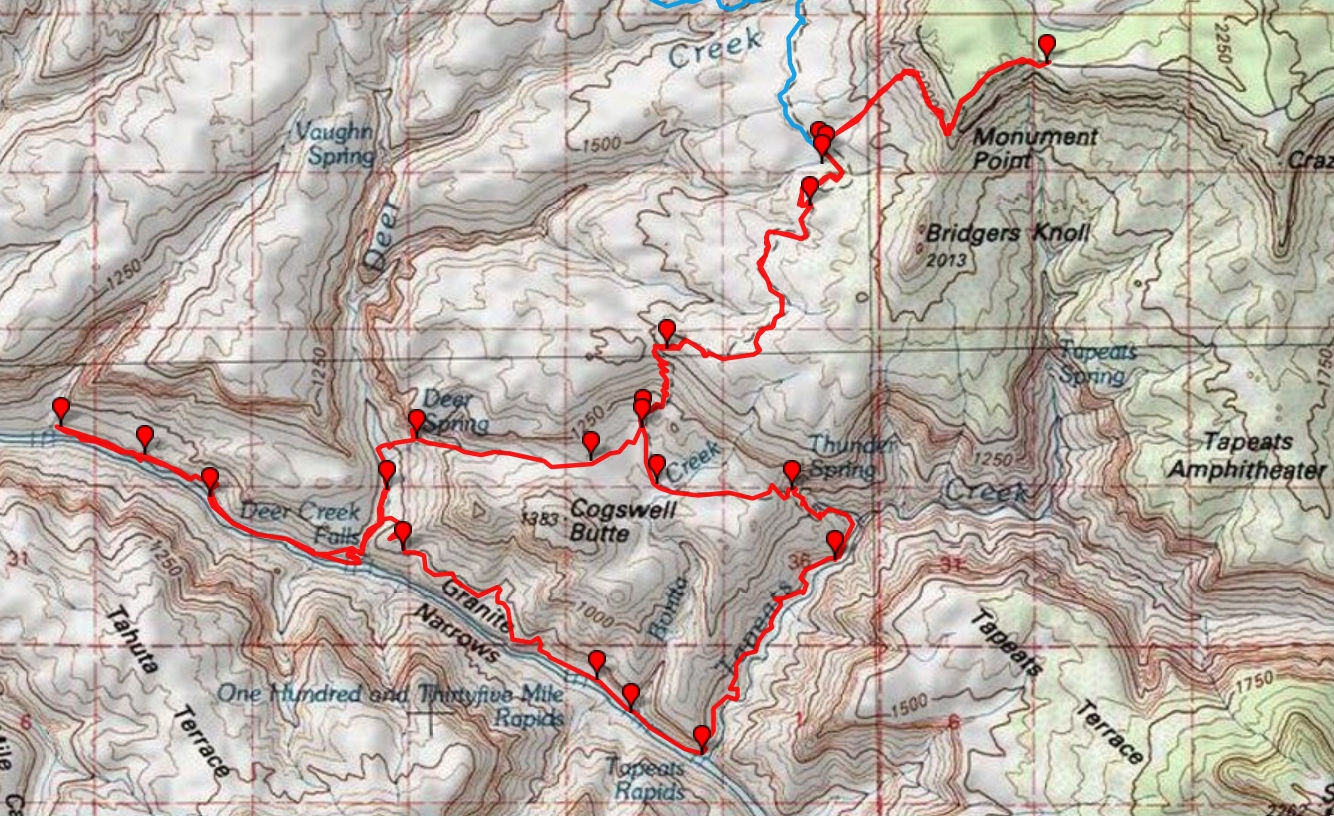
Day 1: Thunder River Trail----> click for a JPG map.
Days 2-7 map----> click for a JPG map.
Whole route in pdf----> click for a pdf map (large file,
decent for printing).
Another
version of the map can be found here.
This web version can be enlarged and may be more useful than the above maps, assuming that
it works for you. ----> click here for the GPS visualizer map - and roam at will.
Preliminary:
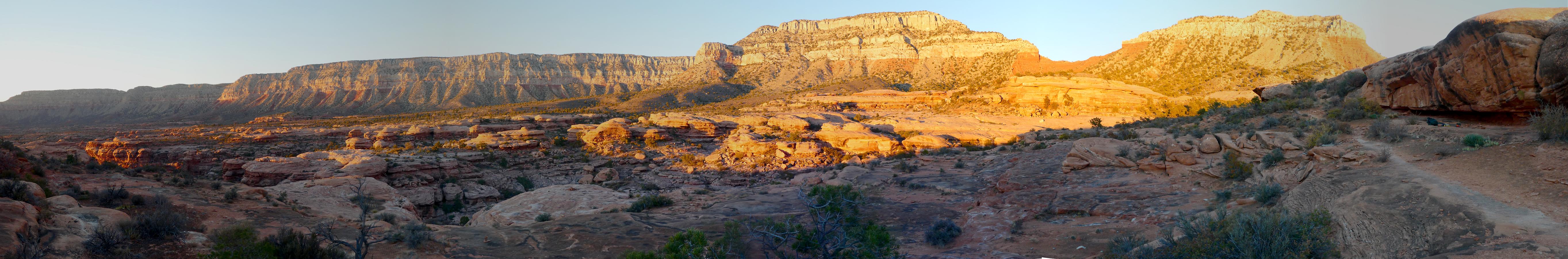
Day 1: Esplanade! Thunder River Trail to the Esplanade:
7 miles, ERM of 14. Camp @ 5400'
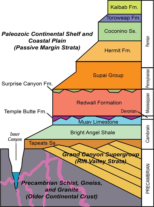
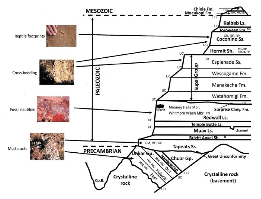
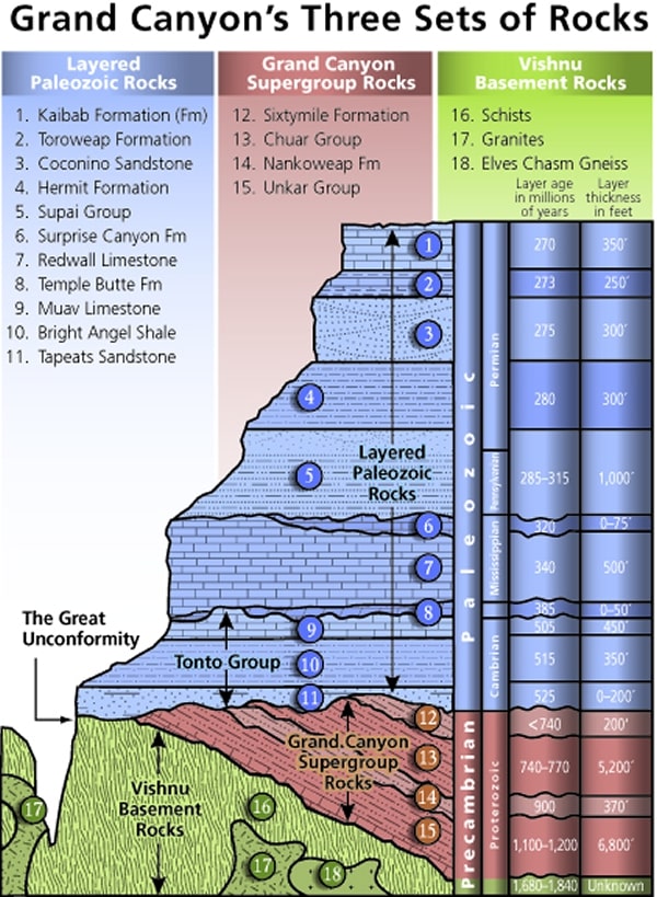
Mnemonic for the basic GC layers - Know The Canyons History, Study Rocks Made by Time
Know - Kaibab Limestone
Know The Canyon's History, Study Rocks Made By Time.

![]()
Three map versions for your scrutiny: (the first version is fastest to load, the pdf version is good for
printing, and the third map is
a web-based map that can be enlarged. You can change the base map (topo, etc.) and move across the route. It will probably stop working
at some point and this is the reason I added the first two map formats.)
Day 0 photos - Thundering Gaiters


On my way to meet the Dusty Gaiters Guild in Jacob Lake, I stop at the Marble Canyon
Bridge (Navajo Bridge) to look for Condors. Walking out on the old Navajo Bridge over The River, I see a dark lump on the arched
girders far above the jade waters of what little remains of Glenn Canyon, fabled place no one knew. "Condor?" I muse. "Condor!"
I exclaim. A quick photo before the juvenile (black head) Condor launches into space and effortlessly glides down River, no longer
in camera range.
Driving on below the Vermillion Cliffs, I stop for a scenic toilet photo, backed by the Cliffs,
and again at the toilet where the AZT, Arizona Trail, crosses 89A.
Meeting Ken, Tom, and Scott snacking on mormon cookies (extra fat) outside Jacob Lake
Lodge, we caravan South on Hwy 67, toward the North Rim of the Grand Canyon before turning off amidst raging Aspen glow onto
FR 22. FR is Forest Road. After 20 dusty miles on FR 22, during which our elevation exceeds 9,000', we branch off to FR 425 and then
the 232 for another 16 miles, where the road deteriorates a bit, to Indian Hollow Camp, and where I spy another scenic toilet and our
camp for tonight. We're traveling the Southern section of FR 22 because the Mangum Fire earlier this year damaged trees and road
North of here and trees are now falling into the road and causing other hazards.
We of the Dusty Gaiters Guild are circled up, lounging in folding chairs and enjoying the quiet
ambiance that is Indian Hollow camp and getting acquainted or re-acquainted. Snacking on hummus, chips, and carrots, I'm washing
it down with beer. A wasp somehow gets inside the beer can and stings my lip with the last gulp. Yoweee! What a painful shock. A
different type of lip smacking, not good.
Stars pop as very cool air slumps down the gradient that is Indian Hollow.
Day 1 photos - Thundering Gaiters


Creeeee, crawwww. The shoulder straps, or perhaps it's my shoulder joints, creak under the
substantial weight of 2 gallons of water plus pack. Ken and I have shuttled a vehicle to the Bill Hall TH (Monument Point) and the four
of us, Ken I., Tom L., Scott H., and I are now shuffling along the Thunder River Trail. The trail is reportedly an old stock driveway and Tom
wonders what the bovines found to eat in this desiccated land. Certainly, I mutter, only someone with a bovine intellect would think
grazing here a reasonable action. Then again, it's yet another example of corporate welfare, in this case welfare ranching, where the
livestockers pay almost zero to graze public lands, billing the public for "improvements" and killing our predators while destroying the
ecosystem for native creatures. Sad and deplorable and continuing to this day, just not in the Park. Ranchers typically vote repulsican,
yet demand incredible amounts of public-funded welfare while destroying the lands and creatures owned by the public. One might
wonder how come they don't adhere to the policies for which they vote - e.g., by paying the private land grazing fee. There's certainly
nothing good about livestock on public lands, and the public is 'getting the business' from welfare ranchers.
After a drop to the Esplanade level, we undulate along in the gathering heat, passing two
diminutive picto panels after a cooked lunch. Cryptobiotic soil grows tall along the trail at times. Scott inquires about this strange-looking
thing that's not quite a plant, probably cannot be soil, right? "Don't bust the crust" we all sing. We don't see anyone until we are almost
to the Bill Hall Junction. A total of four people are encountered today. Crowded.
Wandering the Esplanade beyond the junction with the Bill Hall Trail, we find a nook in which to
camp. We're camping on slickrock, Esplanade slickrock. Gorgeous. The Esplanade is part of the Supai Formation. Scott asks me to
include the mnemonic for the basic GC layers in this report - so look below for this helpful phrase.
Sunset hosts an orange sunset fireball, followed by a pink afterglow, courtesy of the California
wild fires. Who can deny that climate change is a horrible and real threat? Repulsicans can. And do. Information resistant and selfish,
they think only of themselves and tunes sold to them by the extraction industries (big oil, wall street, coal, the GOP, etc.) and ignore the
benefits to them and our only planet by switching to a sustainable energy system. Good and sustainable jobs are a bonus.
Now, after dark, I'm lounging on the sun-heated slickrock drafting these notes as my old joints
and abused arches struggle to recover. Maybe overnight?
Planets shine, followed by a cascade of stars, building in number and intensity and soon anchored
by the Milky Way, vividly belting the desert sky. Spectacular.
The - Toroweap Formation
Canyon's - Coconino SS
History - Hermit Shale
Study - Supai Group (including the Esplanade)
Rocks - Redwall Limestone
Made - Mauv Limestone
By - Bright Angel Shale
Time - Tapeats SS
Check the links section for lots more geology stuff. Here are versions of this basic schemata:
| ||||
| ||||
| ||||
Cryptobiotic soil (once called crypto-gamic soil): a crust of cryptobiotic soil provides a
living ground cover in the high deserts of the Southwest. The soil, consisting of cyanobacteria, lichens, and mosses, forms crusts that
are resistant to wind and water erosion and provide nutrients to plant life.
Cryptobiotic soil crusts are an important part of arid and semi-arid ecosystems throughout the
world, including those in Glen Canyon National Recreation Area, Grand Canyon National Park, Canyonlands, etc. Crypto means hidden,
while biota means life. Hence these crusts are composed primarily of very small organisms that cannot be seen with the naked eye.
Well-developed cryptobiotic soil crust is often much darker than the soil it is on top of, and has a sponge-like look and texture. The
extent of crust development depends on soil structure, texture, and chemistry as well as elevation and microclimate.
Cryptobiotic soil crusts are created by living organisms such as algae, cyanobacteria,
and fungi. The bacteria within the soil release a gelatinous material that binds soil particles together in a dense matrix. The
result is a hardened surface layer made up of both living organisms and inorganic soil matter. This crust is an important means
by which arid soils resist erosion by wind and water. Many cryptobiotic soil crusts are able to absorb water more quickly than
regular soils and as a result reduce runoff and also impede evaporation. In addition, the cyanobacteria in the crust, as well as
some of the surface lichens, are nitrogen fixers, meaning that they can chemically convert atmospheric nitrogen into a form
usable by other plants. Lichens and mosses often grow on the stabilized surfaces of the crust, and can often cover the crusts.
Many unusual and unique organisms occur in association with crusts, including many rare and undescribed algal species as well
as rare lichens. It is becoming increasingly clear that the older and better developed crusts support important levels of cryptogamic
plant biodiversity. (from the NPS Grand Canyon and USGS sites)
Grand Canyon Panorama Project - by Larry Wieland, Thunder River - Deer Creek Loop. You can see the area we hiked by visiting this site. There are many options - click on the spheres to go to a panorama from that point. There are several panoramas taken from the Thunder River Trail, for instance. Options also include: Add geology or topo map. A super series of panos and supporting geology maps. Grand Canyon Panorama Project - Thunder-Deer (link here).
| ||||
 |
 |
 |
 |
 |
 |
 |
 |
 |
 |
 |
 |
 |
 |
 |
| ||||
Day 2: Thundering Fire Hydrant. To Upper Tapeats Camp. 6.5 miles,
ERM of 14.5. Camp @ 2400'.
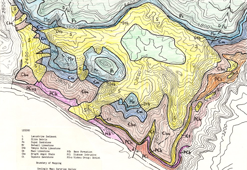
Surprise Valley landslide: Surprise Valley is a surprise because the layers are out of
sequence. It's huge and probably close to 1 cubic mile in volume, making it the largest landslide in the Grand Canyon. It involves the
area between Tapeats and Deer Creek (East to West), and from the Supai dropoff of the trail to The River (North to South). Huge.
Some believe that ground water, perhaps Thunder Spring, may have played a role in triggering the slide. The slide initially dammed
the Colorado River until the river reestablished its course farther South around the edges of the slide. Looking carefully, you will
see sections of Redwall Limestone and the Supai Formation spun around and down there in Surprise Valley, far below their original
positions.
A torrent of chilled water gushes from the Muav Limestone, cascading quickly
downslope, refrigerating the toasty desert air and supporting a host of Crimson Monkeyflowers, willows, cottonwood
and other surprising residents of this oasis. Like a thundering fire hydrant, Thunder River is an antidote to heat stroke
and other dangerous maladies.
We start the day with a lovely tour, Esplanade strolling. We saunter for about two
miles on the Esplanade to the break into Surprise Valley, where we plummet through the Supai Formation on countless
rocky switchbacks. The gigantic land slump from days of yoré has dropped off bits of Redwall and Supai, far below and
far out of the typical geological sequence. Surprise!
Passing two junctions in Surprise Valley, we regain a few hundred feet, a distant
rumble growing louder as we approach the lip of the Thunder River/Tapeats Creek drainage. The rumble emanates from
a curiously out of place grove of greenery far below. More switchbacks and then we creep into the water-cooled goodness
of Thunder River Spring.
Everything is idyllic. Refrigerated air, crisp clear water, deep shade, solitude. Until the
invasion of the hoard of rafters, that is. Apparently unconscious about personal space, certainly ignorant of the MAGAvirus
guidelines and danger, the throng swirls around us, eventually forcing us to retreat away from the oasis, back onto the trail.
More down, to find a camp shoehorned between trail and creek. This is Upper Tapeats Camp.
A dunk in Tapeats Creek is a refreshing shock and removes a pound of salt. Deluxe.
During a fabulous bean and chicken burrito dinner, topped off with apple crisp, the Redwall
glows a salmon pink. Then Scott and Tom spot a lone Bighorn Ram easing down a ramp in our narrow canyon, apparently on a quest
for water. It's way past local sunset, yet we try to photograph this ungulate anyway.
Cool air flows downcanyon, intermittently mixing with hot air wafting up from The River.
A thin slice of sky cleaves the absolute black of canyon walls, with our favorite constellations slowly rotating into view.
| ||||
For more on this and other GC slides, see this pdf
| ||||
 |
 |
 |
 |
 |
 |
 |
 |
 |
 |
 |
 |
 |
 |
 |
 |
 |
 |
Day 3: One and Done. To Lower Tapeats, sand camp. 2.2
miles, ERM of 6.2. Camp @ 1982'.
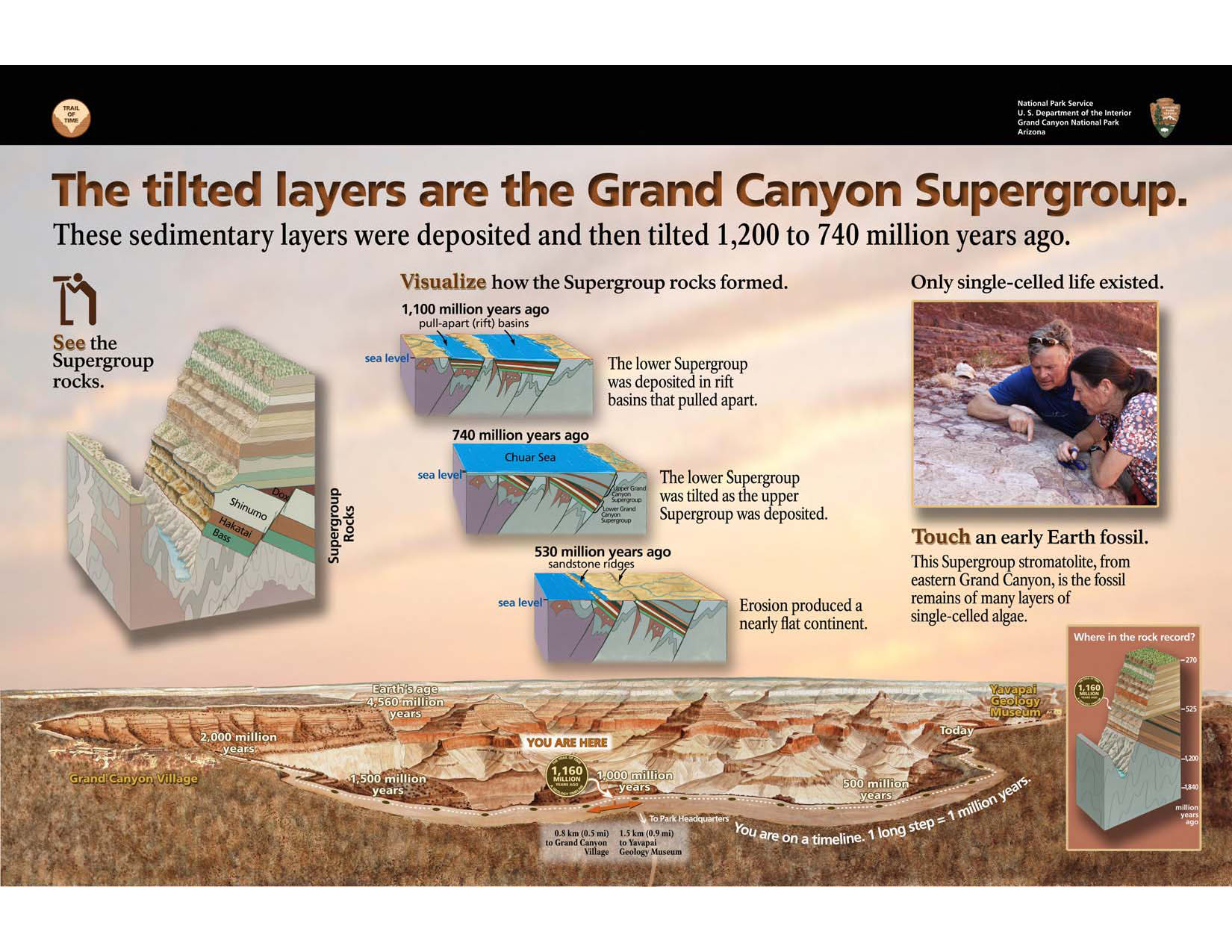
The ledge of rusty red Hakatai Shale narrows to boot width, then squeezes in a smidgen
more. Hakatai Shale is part of the GC Supergroup rocks. (See figure below.) The terrain slopes abruptly and rapidly into Tapeats Creek about 80 precipitous
feet below. The other side of the trail,
occasionally pushing out the pack, is a near vertical cliff. It's a one and done experience; one wrong step and you're done. We're
creeping along the ledges route, choosing to not cross and re-cross the creek on the lower, East, route.
Ken sees an access along the narrow thread between rock band and stream part way
along, at one of the few lower trail dips. Now we're snacking streamside in a deluxe nook, air refrigerated by the creek and the
stream bordered by Crimson Monkerflowers. A churn of falls is just upstream and offers a musical quality to our deserved break.
Ken soaks his feet, Tom and Scott cool down with a bit of creek water and we all lounge on the slickrock, snacking and enjoying
the deep shade and the turbulence of Tapeats Creek. The encroaching sun forces us back on the trail, walking wide ledges until
the steep drop to Lower Tapeats Camp.
It's roasting temperature in the unshaded sand camp area, so we set about plopping
groundsheet place markers, filtering water, wetting the shirt and hiding under the lone decent shade tamarisk to escape the
sweltering orb. Ahh, a functional use for the deservedly much maligned invasive tamarisk, which has so horribly altered The
River and its tributaries.
Lunch is a scrumptious glob of potatoes, smoked hamburger, peas, and corn, topped
with Chalula sauce. Delisciosa.
Whiling away early afternoon, awaiting local sunset and writing notes works well.
Grazing at the Grand Canyon layer cake and listening to the throb of The River is entertainment enough for the middle part of Day 3.
Tamarisk, (Tamarix spp.) commonly known as salt cedar: is an exotic (non-native)
shrub or tree that grows in dense stands along rivers and streams in the West. Tamarisk, introduced to the U.S. in the 19th century
as an erosion control agent, spread through the West and caused major changes to natural environments. Tamarisk reached the
Grand Canyon area during the late 1920s and early 1930s, becoming a dominant riparian zone species along the Colorado River
in 1963 (following completion of Glen Canyon Dam).
The impacts caused by tamarisk in the Southwest are well documented. These prolific
non-native shrubs displace native vegetation and animals, alter soil salinity, and increase fire frequency. Salt cedar is an
aggressive competitor, often developing monoculture stands and lowering water tables, which can negatively affect wildlife
and native vegetative communities. In many areas, it occupies previously open spaces and is adapted to a wide range of
environmental conditions. Once established in an area, it typically spreads and persists. (from the NPS Grand Canyon page)
| ||||
| ||||
 |
 |
 |
 |
 |
 |
 |
 |
 |
 |
 |
 |
 |
 |
 |
 |
 |
 |
 |
 |
 |
| ||||
Day 4: Oh Deery. To Deer Creek Camp.
3.5 miles, ERM of 8. Plus 2 miles to Deer Creek Falls, ERM of 3.5. Total = 5.5 miles, ERM of 11.5. Camp @ 2200'.
Diabase Sill: An intrusion of igneous rock into existing rock which spreads along
bedding planes in a nearly horizontal sheet.
Starting out on our route West along The River to Deer Creek, it's a boulder thrash
initially, followed by a short sand slog, before climbing over a low bluff to the first "oh dear" of the day. One half mile so far.
A slot in the rock slices through what appears to be a dike, creating a downclimb. It's a diabase sill. We Gaiters successfully
inch down without incident, then continue another half a mile of talus hopping to where the routes above and around
the layer cake cliffs begin. Oh dear. It's your basic direct route up before the route begins contouring on a Tontour-like
path until going through a low notch, then descending to Deer Creek, a luscious riparian area of great delight. Along the
way, we pass remnants of old Native structures.
Redwall soars above camp, a spectacular scene for a mediocre campsite by day,
wonderful by night. It's the large group camp that sports the best and most durable shade. And, that's where Tom directs us
for lunch. An excellent suggestion.
Cool water tops off yet another Gaiter lunch, this time stew. Breakfast was eggs topped
with Cholula, wrapped in a large tortillá.
Whiling away part of the afternoon hanging out under savior Cottonwood, we chat about
when to visit Deer Creek Falls and its glorious narrows, and what to do tomorrow. Acknowledging Gaiter Kevin, who had
contributed early organizing and important parts of the meals, we toss around ideas for future excursions. Sadly, Kevin was
unable to join us this time, but you can see him in the report about hiking in the Sierra last year - link.
Then, we hike through the patio area and above the Deer Creek narrows before dropping
to the foot of Deer Creek Falls. Ancient hand prints, negative prints, discretely adorn the narrows wall.
The spray from the falls refreshes.
I dip a toe in The River water to acknowledge the lowest point of this adventure. On the
way back, I see a glow on The River, a soft reflection of light from the Canyon walls.
Pausing at the trailside jacuzzi, I scrub off the trail dust and grime from today and rinse some
laundry before returning to camp. Excellent.
The large group doesn't show, so we enjoy a quiet night with only the burble of Deer Creek to
foster pleasant dreams.
| ||||
 |
 |
 |
Day 5: Full Length of Deer.
3 miles, ERM of 3.5. Stay in Deer Creek Camp a second night.
The chugging burble that is Deer Creek Spring spurts into the dry streambed amidst
Maidenhair Ferns and jade green moss. Suddenly, crystal water in this desiccated land. Tom, Ken, and I have walked up and
beyond the end of the trail going upcanyon, in search of the origin of Deer Creek. It's not an ostentatious, spectacular beginning
like Thunder River, yet delightful all the same. Peering up slope toward the Throne Room and the other Deer Creek Spring,
we don't see any water flying over the notch above the Room, so we leave this exploration to tomorrow.
Back at camp, Ken and I scramble up the West slope to see how come there are
purposely stacked rocks. Old foundations? Hunting blinds? No, remnants of an abandoned trail. Curious.
We invest time lounging under the precious shade Cottonwood and, after lunch,
relocate to the smooth, cool goodness of the Patio in the top end of the Deer Creek narrows.
A few River cloggers (rafters) wander up this far, yet less than the population surge
of yesterday. Deluxe.
Lounging time invested in The Canyon doesn't count in one's chronological march
toward being part of the dirt, not just as old as dirt. There's a return on this investment. A shirt wet in the cool stream, a shady
comfortable spot, excellent companions, a Redwall backdrop and this exuberance is not irrational, unlike the irrational
exuberance of wallstreet. Delightful.
Yet I can feel the skin on the bottom of my feet, and other body parts, cracking and
crinkling from the heat and desperately dry air. Yikes. Is there a generalized malaisé temporarily setting in? Ennui? Is this
compounded by a background of acedia caused by the willful destruction of democracy by trump and the repulsicans? I
hope it's not acedia, yet this pathological narcissistic psychopath has dismantled democracy and protections for health and
environment and there are plenty of reasons to feel discouraged, and more. Argh. In the backcountry we find solace from
the orange clown pufferfish.
We're all feeling the cumulative effects of the journey and the slightly above
temperatures, and, of course, the solar load, and a rest day is most welcome.
Acedia: The mishandling and resulting restrictions on life caused by the MAGAvirus (trump) has produced feelings of acedia. The term acedia arose directly out the spatial and social constrictions of a solitary monastic life. These conditions generate a strange combination of listlessness, undirected anxiety, and inability to concentrate. Together these make up the paradoxical emotion of acedia.
| ||||
 |
 |
 |
 |
 |
 |
 |
 |
 |
Day 6: Stairway to Heaven, or Esplanade Dreaming. 5.6 miles,
ERM of 13.5. Camp on the Esplanade @ 5400'..
Headlamp light gleams off upper Deer Creek as we approach the crossing
of Deer, to begin the first big climb of the day, into Surprise Valley. By the time we've topped off the massive quantities
of water we're totting to the Esplanade, the headlamps can be put away.
Up, up and into the old throne room and Deer Spring, now dry as a mormon
wardhouse on Sunday morning and without a hint there were ever thrones here. Sad. Erosion happens. Global
warming has dried this spring.
Continuing up the steep slope, we enter a draw leading into Surprise Valley,
where we encounter the rays of the burning orb as we inch into the trail delta that forms the routes in Surprise Valley.
More up, growing steeper until we're climbing through the Redwall, then the Supai break and eventually to the
Esplanade, we puff along, gaining about 3500' (and losing 450'), racking up the ERMs. And they're climbing the
Stairway to Heaven.
Esplanade dreaming is becoming a reality.
Strolling the Esplanade is a delight, and in less than an hour after
topping the break we're cloistered under a ranging overhang cooking yet another deluxe Gaiters lunch and
gazing at rocks made by time. Gorgeous.
Some note writing and some exploring down into the canyons drifting
off the Esplanade, and it's time to consider the remaining dinner option.
Sleeping cowboy style (no tent or tarp) on the slickrock, exposed to
billions and billions of stars is a most excellent way to spend the final trip night. Gorgeous.
| ||||
 |
 |
 |
 |
 |
 |
 |
 |
 |
 |
 |
 |
Day 7: Direct Route to Aspen Shimmer. Out of The Canyon via the Bill Hall Trail.
3.5 miles, ERM of 9. @ 2200' of elevation gain, 520 of elevation loss.
Total trip = 33.3 miles, ERM of 72.2
Orion closes out cowboy camping on the Esplanade slickrock. A truly spectacular
night where we of the Dusty Gaiters Guild are enveloped in natural quiet and blanketed by a dark sky of splendid stars,
planets, galaxies (it's new moon). Sleeping out on a slickrock bench has allowed a nearly 360° vista. Yowee.
How come Aspen shimmer? There's a reason for the common name "quaking
aspen." The characteristic fluttering (quaking) of aspen tree leaves is one of their most notable attributes. Aspen leaf
stems are flat in cross-section rather than round. This means aspen leaves can twist from side to side or flutter while
remaining fairly stable vertically. This results in the shimmering aspen one sees on the Kaibab Plateau and elsewhere.
Up and up, we stay in the shade almost all the way to the trailhead today. It's
a direct route climb, gaining 2000' feet in a couple of miles before contouring around the nose of Monument Point, then
gaining more elevation to the point before trailing off and down to the Bill Hall Trailhead. A side trail leads to a plaque
about Bill and how come this trail is named for him.
Retracing the shuttle, we Gaiters bid farewell and safe travels.
Then it's nearly 40 miles of FR (Forest Road) driving through shimmering Aspen,
once again to over 9000', allowing contemplative time to absorb the memories of Dusty Gaiters backpacking Thundering River.
| ||||
 |
 |
 |
 |
 |
 |
 |
 |
 |
 |
 |
 |
A Conservative speech writer evaluates trump:
"Donald Trump has been the worst president this country has ever had. And I don't say that hyperbolically. He is. But he is a consequential president. And he has brought this country in three short years to a place of weakness that is simply unimaginable if you were pondering where we are today from the day where Barack Obama left office. And there were a lot of us on that day who were deeply skeptical and very worried about what a Trump presidency would be. But this is a moment of unparalleled national humiliation, of weakness.
When you listen to the President, these are the musings of an imbecile. An idiot. And I don't use those words to name call. I use them because they are the precise words of the English language to describe his behavior. His comportment. His actions. We've never seen a level of incompetence, a level of ineptitude so staggering on a daily basis by anybody in the history of the country whose ever been charged with substantial responsibilities.
It's just astonishing that this man is president of the United States. The man, the con man, from New York City. Many bankruptcies, failed businesses, a reality show, that branded him as something that he never was. A successful businessman. Well, he's the President of the United States now, and the man who said he would make the country great again. And he's brought death, suffering, and economic collapse on truly an epic scale. And let's be clear. This isn't happening in every country around the world. This place. Our place. Our home. Our country. The United States. We are the epicenter. We are the place where you're the most likely to die from this disease. We're the ones with the most shattered economy. And we are because of the fool that sits in the Oval Office behind the Resolute Desk."
by Steve Schmidt, Republican speech writer for John McCain.
From CNN: https://www.cnn.com/2020/06/23/politics/steve-schmidt-donald-trump/index.html
My summary: Biden 2020; trump 10 to 20. Yuge.
.
*ERM: Energy Required Miles, are there data to support this
mileage adjustment?
Journal of Outdoor Recreation, Education and Leadership
Petzoldt first proposed his theory in his 1976 book “Teton Trails” to
help backpackers plan trips and calculate their energy needs on mountain trails. “Petzoldt defined one
energy mile as the energy required to walk one mile on the flat. He recommended adding two energy miles
for every 1,000 feet of elevation gain, so a person hiking one mile and 1,000 feet upward would use the
equivalent of three energy miles,” Phipps said.
Petzoldt’s energy mile theory was just a reflection of the mountaineer’s
“gut feeling,” Phipps said. The theory had never been tested in a laboratory before the study began in WCU’s
Exercise Physiology Laboratory in the spring of 2010, Phipps said.
To determine the validity of the theory, the study measured the energy cost
and perceived exertion for walking on flat ground, with and without a 44.5-pound backpack, and up an elevation
gain of 1,000 feet, with and without the backpack, through the collection of metabolic data, Phipps said.
Twenty-four student, faculty and staff volunteers, including 12 males and 12
females, went through four testing sessions as the research continued into fall semester of 2010. The study
results showed that the additional energy cost for ascending 1,000 feet ranged from 1.34 to 2.02 energy mile
equivalents, for an average of about 1.6 miles, compared to Petzoldt’s use of two energy miles for each 1,000
feet. The range revealed by the study was due to the “hikers” personal weight differences, Phipps said.
“It is remarkable that Petzoldt’s energy mile theory is so close to the actual energy cost measured during our
study,” Phipps said. “In the field of outdoor education, it’s important for leaders to include an estimation
of energy requirements during the planning of hiking trips.”
Phipps said the energy required for hiking up steep mountain trails would vary
for individuals and groups, and the variables of the trail would also factor in, but he recommends that
backpackers stick with Petzoldt’s idea of adding two energy miles for every 1,000 feet of elevation gain when
planning trips.
The Validity of Petzoldt's Energy Mile Theory, 2010
Authors: Maridy McNeff Troy, Maurice L. Phipps
Publication: Journal of Outdoor Recreation, Education, and Leadership
.
Links:
Link to all WV trip reports about The Canyon (WV)
Grand Canyon Panorama Project - Thunder-Deer.
the geology of the Grand Canyon by Canyon Dave
the geology of the Grand Canyon by the NPS
Falter - Has the Human Game Begun to Play Itself Out on this Eaarth? by Bill McKibben
Other WV reports about the Grand Canyon:
Click here or on the Looking Lizard to go to all WV reports about The Grand Canyon
| ||||
More Truth Than Joke:
| ||||
| ||||
| ||||
| ||||
| ||||
| ||||
| ||||
| ||||
| ||||
| ||||
| ||||
| ||||
| ||||
|
Wild Vagabond Main |
Trip Report Index  |
Caveat  |
|---|


