(November 1 - 5, 2020)
Text © copyright by Rob; and Photos © copyright by Rob Jones of the WV

|
Grand Canyon /
Bóucher Bounce: Hermit Trail / Hermit Rapids / Bóucher Creek & Trail / Esplanade Extension
(November 1 - 5, 2020) Text © copyright by Rob; and Photos © copyright by Rob Jones of the WV |
|
Co-Adventurers: Jerry Wenzel (Speed Shake) and Rob Jones (Wild Vagabond)
Total miles = 28.2; ERM of 58. ERM = Energy Required Miles (see full description below).
camera: Panasonic DMC-ZS70
|
| |||||
|
| |||||
|
| |||||
|
| |||||
| ||||
| ||||
.
.
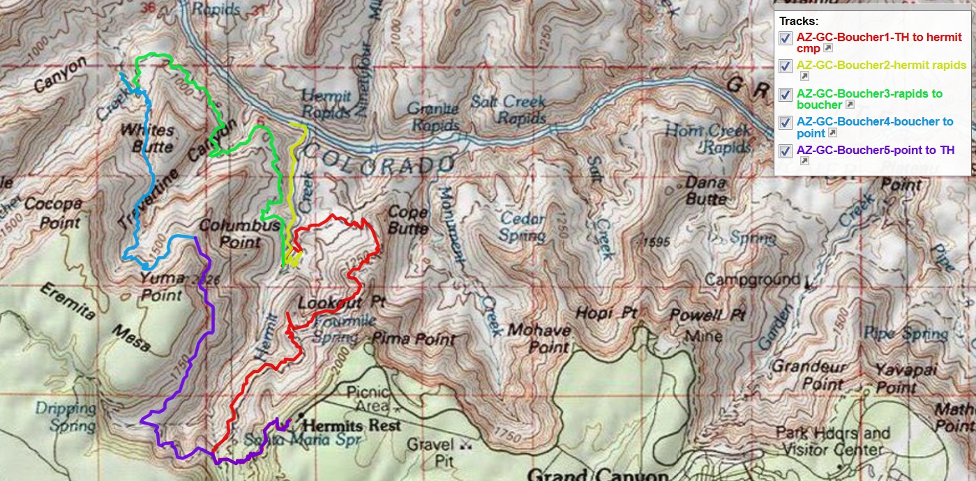
Hermit - Bóucher map ----> click for a JPG map.
Whole route in pdf----> click for a pdf map (large file,
decent for printing).
Another
version of the map can be found here.
This web version can be enlarged and may be more useful than the above maps, assuming that
it works for you. ----> click here for the GPS visualizer map - and roam at will.
Summary:
Day 1: Hermit Ho. Hermit Rest to Hermit Creek:
8.2 miles, ERM of 17. Camp @ 2600'.
Hermit Trail/Camp history: "Hermit Trail, like most other Grand Canyon
trails, began as a Native American route. Ancestral Puebloans used paths in the area to hunt and gather plants, as
did more modern peoples such as the Havasupais.
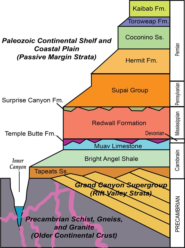
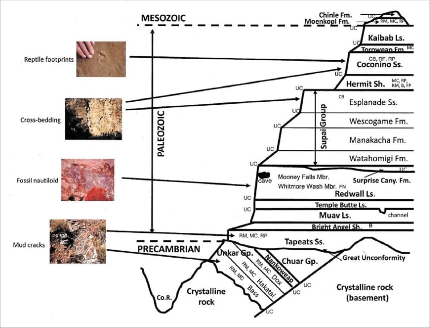
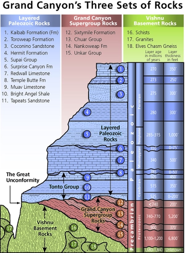
Mnemonic for the basic GC layers - Know The Canyons History, Study Rocks Made by Time
Know - Kaibab Limestone
Know The Canyon's History, Study Rocks Made By Time.

![]()
Three map versions for your scrutiny: (the first version is fastest to load, the pdf version is good for
printing, and the third map is
a web-based map that can be enlarged. You can change the base map (topo, etc.) and move across the route. It will probably stop working
at some point and this is the reason I added the first two map formats.)
Jerry W and I hiked the Bóucher Bounce, consisting of:
down Hermit Trail to Hermit Creek, then to Hermit Rapids before hiking to Bóucher Creek. The final
night was spent on the Esplanade Extension below Yuma Point. We completed the loop by hiking
the remainder of the Bóucher Trail to the Dripping Springs Trail and part of the Hermit Trail to the
rim. We enjoyed excellent weather, natural quiet, dark skies, and good company.
Day 1 photos - Bóucher Bounce


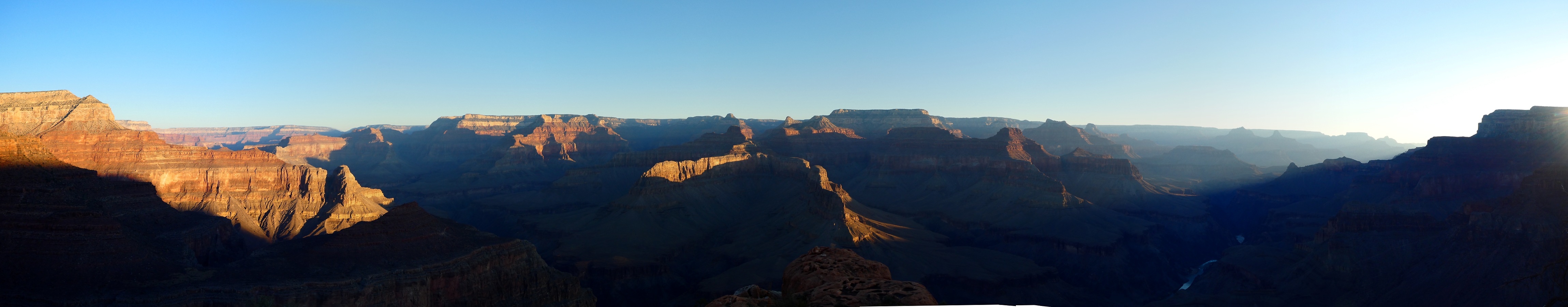
The distant rumble of Hermit Rapids filters up to us, on the
Supai traverse, fifth layer below the rim. Today we're hiking the Hermit Trail from the rim to Hermit Creek.
The sound from the roiling, restless water of The River reverberates against the smooth channel formed by
the towering Redwall Limestone cliffs.
The air tour terrorists aren't yet flying in their 120 decibel sleds, enabling
natural quiet to prevail.
The "we" are Jerry W and me. Jerry obtained an excellent Hermit to
Bóucher permit and invited me to join him after Jerry's friend couldn't go. Thanks Jerry. We meet up at the
Hermit Rest Trailhead after a couple of days of sorting logistics via email and phone.
We've visited the pre-amphibian tracks in the Coconińo Sandstone, marveling
at the well-preserved tail drag marks and the areas that the creature struggled to push through the mud or up a dune,
as evidenced by foot push marks. Fascinating.
Soon we're resting in the Restbit lounge chair in the Santa Maria Spring shelter,
admiring glimpses of the natural rock work on the long- closed scenic toilets and the gorgeous Canyon walls with an
improbable cattail foreground. Lovely.
Continuing on from snack #1, the Supai traverse endures, until reaching the
Cathedral Stairs, which take the direct plunge route through the tough Redwall Limestone. Until it trails off on the
coluvium, to the junction with the Tonto Trail. Snack #2 is enjoyed in a cleft of Cope Butte, just before dropping
out of the Cathedral Stairs.
Local sunset envelopes us as we lilt on refreshing good trail to present day
Hermit Camp, passing the historic Hermit tourist enclave along the way. We agree to return for a proper investigation tomorrow.
Hermit Camp is busy, clogged with tittering twits and other travelers.
Dark collapses on us, signaled by flittering bats and rapacious fat mice, who
dart out from the rocks in an attempt to snatch a morsel of food.
Cool air wafts down Canyon, bringing a hint of the peppermint oil Jerry has
soaked into a string and used to circle his tent. He is using the peppermint oil to deter nocturnal rodents. At least
that's the plan. (It seems to work.)
After the turn of the century, the Atchison, Topeka, and Santa Fe Railway
took over the tourist activities in the area. They desired a trail to bring tourists down into the canyon, since at the time
Ralph Cameron controlled the Bright Angel Trail, the only route into the canyon in the Village area, and charged a toll to
use it. The only other nearby place where a trail down into the canyon could be relatively easily constructed was along
the route of the future Hermit Trail. The railroad wanted to compete with local landowners for the profits that came
from providing tourists with an inner canyon experience.
The Santa Fe Land Improvement Company, a subsidiary of the railroad, surveyed
the route for the Hermit Trail in 1909 and hired the L.J. Smith Construction Company to build it in 1911-12. The railway
named it the Hermit Trail after a French-Canadian prospector named Louis Bóucher, who lived alone and operated several
mines in the area. An eccentric recluse, he earned the nickname “the hermit,” although Bóucher was known for always
being gracious to any tourists who stopped by his home. Many sites in the Grand Canyon are named after him.
The railroad’s partner, the Fred Harvey Company, operated Hermit Camp. Like
most Fred Harvey ventures, the company spent a great deal of time and money making sure the Hermit complex provided
first-class service and accommodations. Guests could stay in well-appointed tent cabins, which featured stoves, Native American
rugs, and windows. Visitors even had electricity, showers, and telephone service. The main building housed a central dining
room stocked with fresh fruit, meat, vegetables, and ice. Altogether, the trail and camp cost about $100,000 to construct, an
enormously costly project for the time.
Tram: Although it no longer exists, the railroad built an aerial tramway that led from Pima
Point to Hermit Camp in 1925-26.
The first section of the 7.5-mile trail drops quickly in a series of switchbacks through
Kaibab Limestone and the Toroweap Formation and on to the Coconino Sandstone. In the Coconino are about 1,000 feet of
switchbacks known as “the white zig-zags.” A retaining wall built primarily from slabs of native stone borders much of the upper
mile and a half of the trail, and there are several continuous sections of well-crafted, hand-laid sandstone creating a smoothly
paved walking surface. Imprinted on the rocks here are several fossilized reptile tracks. Blocks of sandstone have been placed
to form steps leading to different fossil sites to allow visitors a closer look.
From here the trail descends into Hermit Shale until it meets up with the Waldron Trail to the rim, then the Dripping Springs Trail.
After the latter junction it drops into Hermit Gorge, consisting of rocks from the Supai Formation.
At the Tonto Platform, the Hermit Trail intersects with the Tonto Trail, and the two trails overlap for about a mile until Hermit Trail
ends beneath Pima Point alongside Hermit Creek, where Hermit Camp once stood. Here there are several campsites today, and the
cool water of the creek is a welcome relief to hot, weary travelers. A bit downstream from the campsites is a gorge and small
waterfall. Hikers can continue along the creek another 1.5 miles to the Colorado River and Hermit Rapids, though a major trail
was never developed this far and the path is not nearly as well maintained as the rest of the trail.
In its 18 years of private commercial operation, Hermit Camp provided rest and lodging
for thousands of tourists at the Grand Canyon. With urging from the National Park Service (NPS), the railroad abandoned Hermit
Trail and Hermit Camp in the early 1930s during the Great Depression in order to concentrate its efforts at its newer inner canyon
facilities at Phantom Ranch. Several factors made Phantom Ranch a more attractive site. It was accessible from the bustling Grand
Canyon Village at the rail head and situated along Bright Angel Creek a short stroll from the Colorado River. The Park Service had
recently acquired the Bright Angel Trail from Ralph Cameron and completed the South Kaibab Trail and North Kaibab Trail creating
a rim to rim trail linkage that passed through Phantom Ranch. These new constructions were part of a NPS effort to centralize
commercial use of the Grand Canyon in a smaller, more centralized corridor to better protect the environment for future generations."
From ASU GC history, https://grcahistory.org/sites/rim-to-river-and-inner-canyon-trails/hermit-trail/
The - Toroweap Formation
Canyon's - Coconino SS
History - Hermit Shale
Study - Supai Group (including the Esplanade)
Rocks - Redwall Limestone
Made - Mauv Limestone
By - Bright Angel Shale
Time - Tapeats SS
Check the links section for lots more geology stuff. Here are versions of this basic schemata:
| ||||
| ||||
| ||||
the geology of the Grand Canyon by the NPS (23mb pdf file)
Grand Canyon Panorama Project - by Larry Wieland, Hermit and Bóucher Creek area. You can see the area we hiked by visiting this site. There are many options - click on the spheres to go to a panorama from that point. There are several panoramas taken from Bóucher Creek, for instance. Options also include: Add geology or topo map. A super series of panos and supporting geology maps. Grand Canyon Panorama Project - Bóucher Creek (link here).
 |
 |
 |
 |
 |
 |
 |
 |
 |
 |
 |
 |
 |
 |
 |
 |
 |
 |
 |
 |
 |
Day 2: River Eyrie. To Hermit Rapids. 3.5 miles, ERM of 5.0. Camp @ 2380'.
The River roars a frothy green as it spirals and gyrates through Hermit Rapids. Glorious. And deafening.
Although we're ensconced in an eyrie camp 40' above the rapids, I need to almost yell for
Jerry, sitting 8' away, to hear. We will share more normal conversations later this evening. We're up against a gnarly cheese grater
ebony backdrop of basement rocks, predominantly Vishnu Schist, with a full view of The River. No rafters arrive to entertain us with
a run of the rapids. Nor do they arrive with their baloney boats to cater a luscious Dutch oven dinner. Nor beer. Yet loads of most
excellent Canyon time is enjoyed.
We start the day with a thorough exploration of the historic Hermit tourist camp, replete
with cable works, cisterns, tent platforms, buried root cellar - now a hanta virus hovel tool shed, broken glass of assorted colors, a
road from corral to possible cook tent area to the tram/cable works, bricks, scenic toilet, etc. We find a number of cement rectangles
with tubes running through them. The imprints in the cement look like sheet metal stove pipes. What? Perhaps they were used
for running the exhaust gas from wood stoves out, and heating tents along the way Jerry speculates.
Apparently, possible mining of ore was switched to mining tourists. Over at Hermit Camp,
there was once a tram bucket that could be sent from rim to camp, and this was for sending supplies needed by Fred Harvey
Company to mine tourists.
Down through the Tapeats Sandstone gorge we stroll, alongside, sometimes across,
Hermit Creek.
There's interesting geology of pink Zoroaster Granite intruded into the ebony of Vishnu
Schist, and dotted with mica flakes. Fascinating.
Peppermint odor wants by the kitchen as Jerry, trail name Speed Shake, unrolls a peppermint
impregnated string around his tent. But the mice have already chewed on Jerry's pack, nibbling a small hole in it. They dash
about in the rocks, looking for a grub stake. They are ready for us when we arrive, and pounce on our packs before I have the
change to unfurl the ratsack. We quickly secure our edibles.
Jerry dubs my ULA pack "The Tardis" because it seems much larger than it looks. He
expresses amazement at how much stuff comes out of the Tardis. Sometimes I too wonder about how all this stuff fits in the
ULA (it's a ULA Catalyst, made in the USA). I have tried to accumulate US-made gear, much of it by cottage industries. TarpTent
Notch, ULA pack, Feathered Friends sleeping bag, Thermarest pad, Platypus hydration bladder and canteens, Ratsack made
in Flagstaff, socks and wool hat from Smartwool, sun hat by Henschel.
Stars begin to bud out in the GC sky as we finish dinner. Before long, the encroaching
moon washes out the star splendor.
 |
 |
 |
 |
 |
 |
 |
 |
 |
 |
 |
 |
 |
 |
 |
 |
 |
 |
Day 3: Unconformity. To Bóucher Creek. 7.5 miles,
ERM of 13. Camp @ 2790'.
A bit of history, from the Arizona State University site, By Michael F. Anderson:
Bóucher, The Hermit: "The entire network of trails within Hermit Basin (aka
Waldron Basin) is due to Louis D. Bóucher,
an immigrant from Sherbrooke, Quebec, Canada who arrived at the canyon’s South Rim before 1891, when other pioneers of the South
Rim were just starting to stake out their personal spheres of influence. Bóucher chose the area about eight miles west of what
later became Grand Canyon Village, probably for the terrain, which allows multiple opportunities to descend through the typically
steep Kaibab and Coconino cliffs. He probably helped Dan Hogan and others build the nearby Waldron Trail about 1896, and another
early trail from Hermit’s Rest down past Sweetheart Spring to Hermit Basin about the same time. Unlike other canyon pioneers, he
did not immediately record his trails as toll roads, but did record his “Silver Bell Trail” (the historic Dripping Springs and
Boucher alignments combined) in February 1902, only a few months after the Grand Canyon Railway arrived at the rim to the east.
The Great Unconformity: An unconformity is a surface in the rock record
representing a time from which no rocks are preserved. It could represent a time when no rocks were formed, or a
time when rocks were formed but then eroded away. The Great Unconformity exposed in Grand Canyon separates the
Tapeats Sandstone from ancient Proterozoic rocks. It represents about 1.2 to 1.6 billion years of missing rock record,
either due to erosion or non-deposition. It separates the Tonto Group from the underlying, faulted and tilted sedimentary
rocks of the Grand Canyon Supergroup.
The line between the Tapeats Sandstone and the basement rocks is sharply seen.
What's missing here? Millions and millions of years of rocks, or billions and billions?
We're climbing up to the Tonto Platform, where the Tonto Trail resides, from sand
camp at The River. It's a gorgeous canyon, this Hermit.
After a lunch break and some water filtering where the Tonto leaves Hermit Creek,
Jerry and I start Tontouring the Tonto, on the contour, more or less, hiking West.
After nearly three miles on the Tonto, we dip into Travertine Canyon, wondering
at the massive frozen falls of Travertine deposits where a spring apparently trickles into the Canyon heat, evaporating
and leaving behind the calcium carbonate, Travertine. In the drainage, we find a mixed geology wall, conglomerate and
Travertine, and a Travertine natural pipe, and a relaxing deep shade place for lunch #2. Tontouring the Tonto makes for a
glorious day in The Canyon. Lounging in the deep shade of the composite wall, Jerry and I enjoy more Canyon discussions.
Clouds accompany us around the next bulge and into the Bóucher drainage.
Three canyons confront us when we can see into the Bóucher area. One is Topaz,
one is Bóucher, and the other is where the Bóucher impossibly exits The Canyon. Yowwee. We both eye this notch with
awe, wondering if this is truly the vaunted route through the Redwall.
A huge buck deer bounces out of a side canyon, then saunters and poses, waiting
patiently for the photo shoot.
The trail starts dropping, passes the junction with the Bóucher Trail, and continues
down to a camp near burbling Bóucher Creek.
It's way past local sunset, yet we walk the short distance to the remains of
Bóucher's stone cabin, and then to his adit. There's not much to either.
Reportedly, Bóucher developed an orchard below the cabin, but we see nary
a sign of it.
Light is fading fast as we gather water, and a puffy orange sunset prevails. Dark
ensues. Cool air flows down canyon.
We are besieged by a cadre of mice, then gusts of dusty wind, while cooking dinner.
Argh. The mice are so brazen that they appear on the cook rock where the stove is running.
After hanging the ratsack on a venerable mesquite, the mice assault eases some.
Calm has also returned and Bóucher Creek is delightfully heard trickling, tinkling, burbling as our star accompaniment makes
itself known. We have seen no other hikers today. Deluxe.
Bóucher is an enigmatic historical character, known after 1910 as “the hermit.” There is little
doubt that he was eccentric, riding about the area on his pure white mule, Calamity Jane, and seemingly preferring his own company
to others—odd behavior for an early tourist guide. The Santa Fe Land Development Company apparently labeled him The Hermit after
they bought out his interests to build their own Hermit Trail in 1909, no doubt to add a little romance to their advertisements,
but he was not a true loner.
....despite his publicized proclivity for being a hermit, he has more canyon features named for
him than nearly all other pioneers combined: Bóucher Creek, Canyon, Trail, and Rapids; Hermit Rest, Road, Trail, Camp, Fault,
Basin, Creek, Rapids, and Shale; and Eremita (Spanish for Hermit) Mesa and Tank. A hermit in life, perhaps, but in the afterlife
he is as well remembered as a rock star!"
Day 4 photos - Bóucher Bounce


Day 4: Esplanade Extension. Up the Bóucher to below Yuma Point.
4 miles, up 2500', ERM of 10. Camp @ 5330'.
The Northern view ranges to the North Rim, collecting big buttes and
temples and such along the line of sight. Spectacular. A breathtaking vista is available at the Esplanade Extension.
Mistaken and poorly informed hikers call it "Yuma Point," yet Yuma Point is over a thousand feet higher. It's the
Esplanade Extension.
Its been a long day of climbing straight through the contours. No Tontouring
the contour today. First up, the grind through the Tapeats, Bright Angel Shale, Muav Limestone, and the cheesegrater
that is the Redwall Limestone. We're hauling extra heavy water for a dry camp on the Esplanade Extension, about 14
pounds of water, each. Argh. Up to the White Butte saddle, where there's scant shade, yet we find a smooth rock
mini-patio behind a Coconińo boulder offering deep shade. Glorious. It's way past time for lunch #1, which is well
received by growling stomachs.
Air tour terrorists intermittently interrupt the Canyon aura. Hideous. An example
of corporate welfare. Our precious resources, natural quiet and visual wonder, are abused without paying the public for
the loss of these dear and rare resources, for the sake of unearned corporate profits. Corporate welfare.
After looping around the bottomless canyon, walking on the top of the Redwall,
we come to the drainage where the Supai climb begins, and weaves a bit, yet basically goes up and up before lateralling
and more up. To the Bóucher lift, a scramble to where it's a short bit more climbing and then roving over to the Esplanade
Extension. Jerry wants to stop, and luckily so, because I was in the process of walking past the Extension, thinking it was
above the next peninsula of rock.
Finally to camp. Yahoo. It's been slow going today. The low angle sun is setting
the rocks made by time aglow. A full palette of soft colors paints the rocks of the Northern view.
A full horizon to horizon starscape reveals itself as dark thirty arrives. A rare dark
sky night, accompanied by natural quiet so profound that we can hear Hermit Rapids thousands of feet below. And all this
wildness accentuated by another day without seeing other people. Superb. Jerry situates his tent on the edge of the
profound drop off the Extension, gaining an inclusive Canyon view in addition to all-around stars.
The intrusive moon will eventually wash out the billions and billions of stars, yet
sleep will beckon before then.
 |
 |
 |
 |
 |
 |
 |
 |
 |
Day 5: Return of the Hermits. To Hermit Rest. 5 miles, ERM of 13. Up to 6700'.
28.2 total miles, ERM total of 58.
The sunrise is spectacular. And more. I find myself ignoring the couscous with Mandarin
oranges, raisins, good stuff, and the super mocha grandé coffee elixir in deference to the awesome vistas of changing
light and color. Wowee.
Natural quiet of Granite Rapids and Hermit Rapids fills the soundscape. There are no air tour
terrorists yet. A pox on air tour terrorists. Hiking the Bóucher Bounce has been a welcome and refreshing break from feelings of acedia.
We lounge and enjoy the evolution of Canyon views into late morning. Glorious. Finally, it's time to pack and complete the Bóucher
Bounce, sauntering along the remainder of the Bóucher Trail to where it meets the Dripping Springs Trail, then this trail to where it
meets the Hermit, and finally bouncing out of The Canyon on the Hermit Trail, back to the rim; a beautiful Bóucher Bounce.
Acedia: The mishandling and resulting restrictions on life caused by the MAGAvirus (trump) has produced feelings of acedia. The term acedia arose directly out the spatial and social constrictions of a solitary monastic life. These conditions generate a strange combination of listlessness, undirected anxiety, and inability to concentrate. Together these make up the paradoxical emotion of acedia.
| ||||
 |
 |
 |
 |
 |
 |
 |
 |
 |
 |
 |
 |
Heather Cox Richardson, November 4, 2020 said:
"The problem of voter suppression is compounded by the misuse of the
Electoral College. The Framers originally designed delegates to the Electoral College to vote according to districts
within states, so that states would split their electoral votes, making them roughly proportional to a candidate’s
support. That system changed in 1800, after Thomas Jefferson recognized that he would have a better chance of
winning the presidency if the delegates of his own home state, Virginia, voted as a bloc rather than by district. He
convinced them to do it. Quickly, other state officials recognized that the “winner-take-all” system meant they must
do the same or their own preferred candidate would never win. Thus, our non-proportional system was born, and
it so horrified James Madison and Alexander Hamilton that both wanted constitutional amendments to switch the
system back.
Then, on November 7th, another history missive from Dr. Heather: "Today at about 11:30 am, the media called the 2020 US presidential election.
The winners are the Democratic candidate, former Vice President Joseph R. Bidden, Jr., and his running mate-- the first
woman elected to the vice presidency-- California Senator Kamala Harris.
My summary: Biden 2020; trump 10 to 20. Yuge.
.
Democracy took another hit from that system in 1929. The 1920 census
showed that the weight of the nation’s demographics was moving to cities, which were controlled by Democrats,
so the Republicans in control of the House of Representatives refused to reapportion representation after that census.
Reapportioning the House would have cost many of them their seats. Rather than permitting the number of
representatives to grow along with population, Congress then capped the size of the House at 435. Since then,
the average size of a congressional district has tripled. This gives smaller states a huge advantage in the Electoral
College, in which each state gets a number of votes equal to the number of its senators and representatives.
These injuries to our system have saddled us with an Electoral College that
permits a minority to tyrannize over the majority. That systemic advantage is unsustainable in a democracy. One or
the other will have to give."
It is a new day in America.
The last four years have been a struggle for the survival of American democracy.
That struggle has been no less fundamental than the Civil War or World War II, for all that our people died not from foreign
artillery but in hospitals and under the knees of police officers.
A majority of Americans spoke up this week to reclaim our fundamental values:
equality before the law and equality of opportunity. This was a huge win. The Republicans did all they could to disfranchise
Democratic voters, yet as of tonight, Bidden and Harris are ahead by more than 5 million votes, with more votes still to be
counted.
This victory, the defense of a government “of the people, by the people, for the
people,” belongs to everyone who refused to let right-wing talking points go unchallenged any longer, who called their
congressional representatives, who wrote letters to their local newspapers, who filled out a ballot, who ran for office. It
belongs to everyone who stood up for America as a land of freedom and possibility, rather than a land of carnage.
It belongs to you.
If there is anything the last four years have taught us, it’s that we are our own saviors.
The struggle to protect our democracy is not over, not by a long shot. Already
Trump’s supporters are insisting that the vote was rigged and the election stolen, and they are vowing to fight. Popular
right-wing media hosts are egging them on. Meanwhile, Trump’s term does not end until January 20, 2021, and he will
almost certainly use that time to take revenge on those he blames for his loss, that is: us. The next two months are going to be rocky.
While this election saved democracy for now, the forces that gave rise to Donald
Trump’s presidency have not been vanquished. America is still under siege by oligarchs who are trying to take control of
the country. They win supporters by spinning a false narrative that feeds fear and fury to drive ordinary Americans apart.
And, as we now know, 70 million voters are open to their narrative, even if it means children torn from their parents, half
of the country demonized as anti-American, a lawless administration, a deep recession, and more than 230,000 Americans
dead.
For my part, I believe that the way to defang this cabal is by rejecting its lies and
returning fact-based argument to the center of our national conversations. Going forward, I will continue to do my part
to make that happen.
But whatever the future brings, there is no doubt that today is ours. After four
years in which we have indulged the worst of our nation, we have voted to reclaim the best.
Thank you all for this day."
*ERM: Energy Required Miles, are there data to support this
mileage adjustment?
Journal of Outdoor Recreation, Education and Leadership
Petzoldt first proposed his theory in his 1976 book “Teton Trails” to
help backpackers plan trips and calculate their energy needs on mountain trails. “Petzoldt defined one
energy mile as the energy required to walk one mile on the flat. He recommended adding two energy miles
for every 1,000 feet of elevation gain, so a person hiking one mile and 1,000 feet upward would use the
equivalent of three energy miles,” Phipps said.
Petzoldt’s energy mile theory was just a reflection of the mountaineer’s
“gut feeling,” Phipps said. The theory had never been tested in a laboratory before the study began in WCU’s
Exercise Physiology Laboratory in the spring of 2010, Phipps said.
To determine the validity of the theory, the study measured the energy cost
and perceived exertion for walking on flat ground, with and without a 44.5-pound backpack, and up an elevation
gain of 1,000 feet, with and without the backpack, through the collection of metabolic data, Phipps said.
Twenty-four student, faculty and staff volunteers, including 12 males and 12
females, went through four testing sessions as the research continued into fall semester of 2010. The study
results showed that the additional energy cost for ascending 1,000 feet ranged from 1.34 to 2.02 energy mile
equivalents, for an average of about 1.6 miles, compared to Petzoldt’s use of two energy miles for each 1,000
feet. The range revealed by the study was due to the “hikers” personal weight differences, Phipps said.
“It is remarkable that Petzoldt’s energy mile theory is so close to the actual energy cost measured during our
study,” Phipps said. “In the field of outdoor education, it’s important for leaders to include an estimation
of energy requirements during the planning of hiking trips.”
Phipps said the energy required for hiking up steep mountain trails would vary
for individuals and groups, and the variables of the trail would also factor in, but he recommends that
backpackers stick with Petzoldt’s idea of adding two energy miles for every 1,000 feet of elevation gain when
planning trips.
The Validity of Petzoldt's Energy Mile Theory, 2010
Authors: Maridy McNeff Troy, Maurice L. Phipps
Publication: Journal of Outdoor Recreation, Education, and Leadership
.
Links:
Link to all WV trip reports about The Canyon (WV)
Bóucher Trail description - pdf (NPS)
Hermit Trail description - pdf (NPS)
Grand Canyon Panorama Project - Hermit-Bóucher Creek (link here).
the geology of the Grand Canyon by Canyon Dave
the geology of the Grand Canyon by the NPS (23mb pdf file)
Falter - Has the Human Game Begun to Play Itself Out on this Eaarth? by Bill McKibben
Other WV reports about the Grand Canyon:
Click here or on the Looking Lizard to go to all WV reports about The Grand Canyon
| ||||
More Truth Than Joke:
| ||||
| ||||
| ||||
| ||||
| ||||
| ||||
| ||||
| ||||
| ||||
| ||||
| ||||
| ||||
|
Wild Vagabond Main |
Trip Report Index  |
Caveat  |
|---|


