|
|
|
|
NPS site for Fossil Butte: http://www.nps.gov/fobu/
Highest point in each of the United States (America's Roof): http://www.americasroof.com/
Links to the Oregon Trail:
http://www.over-land.com/trore.html
Link to another trip report
about the Wind River Mountains:
Ecobust Along New Fork: A Super-Natural Figure-8 in the Bridger Wilderness of the Wind River Mountains;
September 3-13, 1987
Wild Vagabond Main  |
Trip Report Index  |
Caveat  |
|---|
|
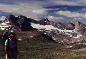
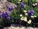
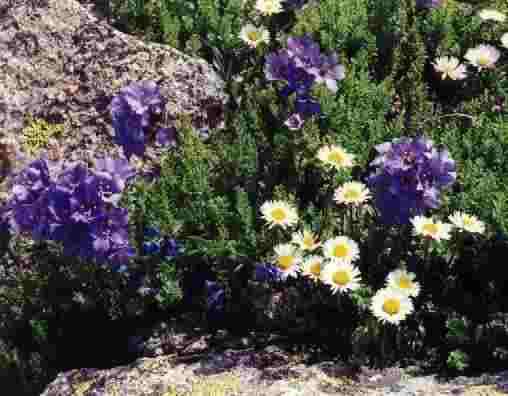
Popping out from the fir forest, the opening broadened into Fish Creek Park, carpeted with a dozen species of colorful cushion plants, their subtle colors back staged by the dark granite teeth hogging the entire North skyline. I'm rolling upward, about 4 miles into my first Wind River Range day, and I've seen a glorious arrangement of wildflowers already. Out in the park, a single figure in bright orange waves something over his head. "What is a golfer doing out here?" I wonder out loud. "Yes," I reply, "it looks a lot like the Scottish highlands, where golf originated." I enjoyed a good laugh.
Yesterday, 7/31, I drove the approximately 280 miles from Smog Lake to Big Sandy Opening, starting at a leisurely time and visiting a few of the Oregon Trail sites between Farson, WY and South Pass. I also drove the loop to South Pass City and Atlantic City, old gold boom towns now barely subsisting by mining tourists. From near South Pass, I began the 36-mile dirt road venture to the trailhead (TH), which was good going except for the last 10 miles, which were a bit rough. The TH looked like a mall parking lot, but it wasn't filled to capacity. I was up until 11 p.m. entering coordinates for my anticipated loop route into my GPS.
I had pared-down my pack weight with greater care to food and what I brought, but my bones and shoulder straps creaked as I inched past Mirror Lake and continued on to Dads Lake. Thunder echoed in from the East and a few drops blew in on me. I camped just below Marms Lake.
Leaning against a granite boulder, rounded then dropped off by one of the last glaciers, I'm looking down to Dads Lake which is a deep green with a fringe of sunset orange on the firs along the East shore. I've resorted to wearing my mosquito headnet and hiding below the smoke from the fire, which I started to burn a huge wad of duct tape, a towel, etc., left by some folks who probably spend most of their time riding in the blue smoke of the ORV ecotrasher. Thankfully, there are no mechanized ecotrashers allowed in this haven. I'm thinking about how lucky I am to be part owner of this land and how, so far, it's been ideally suited for future llama treks. I've dreaming of a long hike with these hospitable harmonica-nosed pack creatures.
|
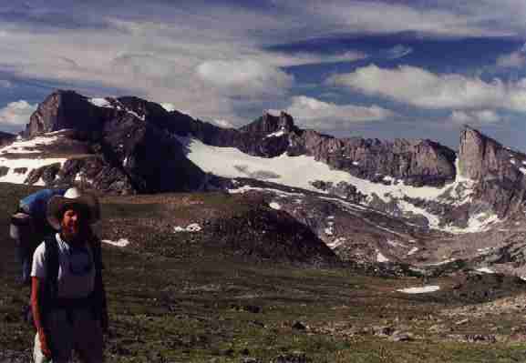
Day 2: Cirque de Pyramids: Marms lake (9878') to Skull Lake (10,282'), 4 miles; day hike to Pyramid Lake, 6 miles; total of 10 miles, ERM of 12.) I find myself daydreaming about how come my hat seems to be a full size too small. Ahh yes, I remember, mosquitoes. Then, I look up from my writing and see, yes, the Cirque de Pyramids. From East to West I see Mt. Washakie astride Washakie Pass, my destination for tomorrow, Bernard Peak, Dike Mountain, Pyramid Peak, the hulking form of Mount Hooker, Tower Peak, glissade Peak, Ambush Peak, and Mount Geikie, all over 12,000' and appearing to be an extension of my backyard rock and flower garden. I'm camped above Skull Lake, off the trail to Washakie Pass.
Today, I hiked through the polished boulder meadow near Washakie Creek to near Skull Lake at 10,282.' After a second lunch, I day-hiked past Mae's Lake and on to Pyramid Lake (10,570'). It was a glorious day of rambling through the granite boulder-infested tarns and cirques of this magnificent Wind River Range.
Along the way, I met two lads from Chicago, one nursing an injured knee, and a father and two adult daughters from Knoxville, Tennessee, an overly ambitious scout group from Seattle, a large NOLS group, and several other groups. Many parts of the country are well-represented in these crowded mountains.
There is a fading remnant of copper glow on the knife-edge of Pyramid Peak and the massive hulk of Mount Washakie as sunset fades from the heavy bottom billows of nearly total cloud cover and coolness and dark settle into my deluxe camp. I invite the Tennessee group to my campfire and hear their tales of woe.
I first saw the folks from Tennessee as they rode past me on horses in Fish Creek Park. The next time, I saw them camped near the junction near Marms Lake, and again after I returned from my day-hike to Pyramid Lake. The Father reported "We hired this outfitter to take us and our packs to Washakie Pass. From the pass, I planned to hike around the loop to The Cirque of the Towers and back to Big Sandy Openings. I have been here, several years ago, and I knew I needed a head start to finish the loop. But last night, the outfitter took us way over toward Silver Lake (the wrong way), and by the time we got back, it was too late to ride up to the pass. So, here we are, struggling to get to where we thought we would be yesterday." I wondered out loud about who was responsible for getting these hikers to where they had contracted to go. Their dream plan turned out to be an expensive, butt-bruising, detour to nowhere. But, what a beautiful nowhere it is.
I am happy I brought a full compliment of clothing, including Sinclair pants (they're bug-proof). As the sun sets, it cools dramatically, and I feel in my leaded feet some of the many thousands of miles I have hiked.
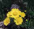
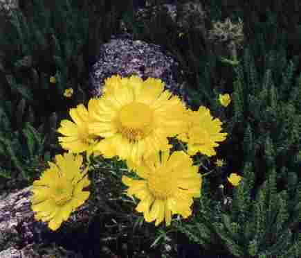
Day 3: Hey, Hey, Do the Washusi! Or, Cacophony at the Continental Divine: (Skull Lake (10,282') to Washakie Pass (11,611'), climb Mount Washakie (12,524'), to Washakie Lake (10,363'), 4 trail miles, 2 miles to peak, 10 ERM.) The odor of early stage rotting meat, or essence of skunk, wafted to my nostrils. It originated close by, off the 50 degree angled meadow dotted with lichen-speckled granite boulders. Puffing hard, and bent over enough that my nose was fairly close to the forbs, I nearly nosed into a low-rider sun-burst of The Old Man of The Mountain sunflower. Over there the magenta radiance of a primrose sparkled. And that aroma, it seemed to be coming from those royal grape-colored Sky Pilots with their yellow star eyes. "What an ostentatious display," I thought, as a Ruby-Throated Hummingbird zoomed past. Here I am, over 12,000' high and on my way to Mount Washakie (12,524'). Low-rider Phlox, Cinquefoil, and other stuff completed the alpine carpet.
I started fairly early from my deluxe camp, and began the trudge to wide open Washakie Pass (11,611'), where I earned dramatic views of Washakie Lake and the terrain all the way to Valentine lake, perched across the cirque. Here I left the Bridger Wilderness and entered the Popo Agie (pronounced "po-po-zha") Wilderness with further developing views of the Cirque de Pyramid (my name). After lunch, I climbed Mount Washakie, or, as some Southern hikers called it "Washusi." As I returned to the pass, dark clouds boiled in and I hurriedly ate lunch #2 in the beginning cacophony of shrieking winds. Hurriedly terminating lunch, I kick-stepped down two brief snowfields to the rocky trail to Macon Lake. "Alfie the Llama would not like the section from the pass to Macon Lake," I said out loud. Finally, there was dirt on the trail as I dropped toward Washakie from Macon, and into wind-interrupting timberline. Washakie Lake is a large blue wonder and I am glad to see it because I am suffering from flat feet. So, I stopped for a foot break and lunch #3 where the trail first approached Washakie Lake, although I had not covered many trail miles. My hike today was a net 80' or so elevation gain, although I had gained and lost over 2,000' in the process.
I am camped on a bluff 50 or so feet above Washakie Lake, lounging in a clump of firs, and enjoying a smokey fire in an established fire ring. The wind has a November nip to it and the black boils in the gray clouds occasionally spit at me. I mused about the horse group from Alabama, sliding down the snowfields, ever the gentlemen, they helped the female outfitter while sliding like otters on the pond edge.
Day 4: Beary Rainy: (Washakie Lake (10,363') to Ranger Park (10,000') to near Little Valentine Lake (10,800'), visit Dutch Oven Lake, 6 miles, 7 ERM.) Rain, now hail, jack-hammers on the tent as what appears to be three separate layers of cloud open up on me. I am cold despite wearing two layers of polypro and hiding in the sleeping bag. The pounding subsides long enough to hear garbled expletives coming from somewhere above. Have the angry mountain spirits come to get me? No, hikers are caught out in the storm and apparently hurrying down the Bears Ears Trail, probably in search of more tree cover, because I am just into timberline at 10,800' near Little Valentine Lake. After a nap, once warm, and some more waiting, the storm breaks and I escape from the tent to fix dinner and stretch. Now, about 8 p.m., I'm sitting on my granite veranda, watching the clouds reel around the peaks and waft through Ranger Park nearly 1,000' below.
Today, I hiked down to Ranger Park, where I joined the Bears Ears Trail and forded the South Fork Little Wind River. I attempted to wash all my clothing and equipment at once by slipping off the slimy boulders and face-planting in the river. So, I enjoyed gorp #1 while drying feet, etc. The mosquitoes have been less numerous since I entered the Popo Agie, so a long gorp stop was enjoyable. Then, I climbed up to Valentine Lake for gorp #2, and day-hiked the short distance to Dutch Oven Lake, apparently named for its round outline and the tiny island (the handle?) in the middle.
Inspecting the map and marveling at how high the Lizard Head Trail goes, my chore for tomorrow, I decided to push my luck and hike some more above Valentine Lake, toward timberline. Campsites were few, but I found one near an old, old trail not too far from Little Valentine Lake. My favorite part today was the glimpse of a pink on yellow sunset that peeped through a cloud, and the big knarly teeth of the continental divide. I am relieved I stopped early, and set-up camp before the storm rolled over me.
|
|
Day 5: Salamander Crossing: (Little Valentine Lake (10,800') to Lizard Head/Windy Mountain (11,900') to Lizard Head Meadow (10,040') 8.5 miles, 13 ERM.) After crossing the snowfield above the junction of the Bears Ears and Lizard Head Trails, I continued to climb as I rounded the high nose of Cathedral Peak and crossed over contour 11,900' onto the undulating alpine plateau loosely called Windy Mountain. Here, on the trail, I am higher than the highest point in 39 of the United States (see the America's Roof site). It's fabulously open country, where the tallest plant is the towering Old Man of The Mountains big-headed sunflower at a staggering 5" tall. It's a uniquely spartan terrain filled with solitude and long-ranger vistas to distant Lizard Head Peak and glacier accompanied by lots of other granite monolithic mammoths. Much higher than most passes, I tramped along briskly, eyeing the already developing thunderheads.
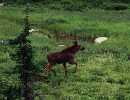
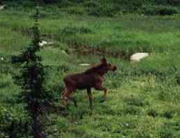
I was up early and climbing the big-U ramp above Upper Valentine Lake, leaving treeline just above camp. After a mile and a half, the trail came to a great precipice, the plunging abyss South of Mt. Chauvenet. Here, the Bears Ears Trail climbs over the mound to the North, then heads East down Sand Creek toward distant Dickinson Park. I am going the other way, beginning my journey on the sky walk called The Lizard Head Trail. The way I approached it was the easier way, because on the far end, there is a steep and long descent into Lizard Head Meadow. As I was in the midst of this long descent and approaching the junction to Bear Lake, it began to hail, then the hail stopped as I entered the dark forest, the first trees I have seen since Little Valentine Lake. Rain spit, or poured, the rest of the day, making me think "salamander" was a better name than Lizard Head. Now in the Lizard Head Meadows, I waded the bank-full outlet from Bear Lake and camped near the North Fork of the Popo Agie River. Great camp. A calf moose visited, and I briefly enjoyed a drying/warming fire and dinner before the next storm wave forced me back into the tent. Lizard Head Peak looms above me, and sometimes I see it through the overburden of mist and clouds.
|
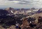
Day 6: Misty Memories: (Lizard Head Meadows (10,040') to Lonesome Lake (10,166') to Jackass Pass (10,800') to Big Sandy Lake (9,690') to Diamond Lake (9,485'); 9 miles, 11 ERM.) "I can see the snaggle nose coming back into view" I muse to myself. I look up into the flints of cold mist to see some of the gray clouds roll back from the monoliths ringing the Cirque of The Towers. I pause for what might be a prize winning photo on another day. But, today, there's no bright blue sky and I can glimpse only part of the Towers at any one time. I've just passed Lonesome Lake, and I'm on my way to Jackass Pass, somewhere up in the shifting, swirling, occluding miasma of vapor and low clouds.
I arrived at the lake just in time to see what turned out to be a scout from a troop from New York dipping his water bottle in the lake. Following his apparent path of approach to the lake, I see a large contingent camped less than the standard 200 yards from a lake and a huge amount closer than the special .25 mile camping limit for often-visited Lonesome Lake. Well, I considered, not all scouts are produced to the same standard as the Seattle group, who recounted to me how they had prepared a year for this hike. Further consideration would lead one to wonder if there is a natural (amoebae) consequence in store (in gut?!) for the offending scouts?
Continuing up into the mist, I found a plethora of routes, but I apparently was never on the trail. Just the same, it was an easy climb through a field of giant "erratics" to the pass. I arrived in a burst of rain, and headed down the obvious route without proper inspection of the route or map. The trail quickly ended at a boulder field, my feet nearly in Arrowhead Lake. Rather than return and getting on the correct route high above and on the East side, I continued, forward. On I bouldered and scrambled, eventually meeting the trail and descending to North (Shaft) Lake. The sun appeared for lunch.
Continuing down, I hiked to Big Sandy Lake, destination for many hiking from Big Sandy Openings. "Clear Lake, Diamond Lake, slog out 6 miles to the TH?" I asked. I decided the weather was enticing and headed for Diamond Lake. Once I left the Big Sandy trail, I felt back in the wilderness. I stopped at Diamond Lake and began to warm water with my precious remaining fuel. As soon as I set up a shower, it began to rain. I was not able to finish showering as the storm thundered over Diamond Lake, and a torrent pounced in when I was good and wet. After hiding in the tent, I finished with a rain rinse. The storm cleared and I enjoyed aquamarine skies for dinner and a pleasant fire.
I'm finishing the notes for today by a mirror-smooth Diamond Lake, its surface reflecting grand granite bumps turning a salmon pink. All is well except the few raindrops that prompt me to end this entry, apparently blown in by a vagrant, ephemeral wind.
Day 7: Diamond Down (or, Easy Out): (Diamond Lake (9,485') to Big Sandy Openings (9,100'); 4.5 miles, 5 ERM; and visit Fossil Butte N.M. near Kemmerer.) A rosy glow added sparkle to the frost and dew in the meadow abutting Diamond Lake. Ground- and lake-hugging drifting vapors slowly swirl over the billions of prismatic dew drops drooping from the grass stalks. It's sunrise at Diamond Lake camp.
The sky was a recently unusual clear blue as I enjoyed a morning fire and leisurely packed and headed into the long shadows of morning, bound for V Lake. Through the coolness of the pines and firs I walked, arriving at the junction that leads North to Fish Creek Park and South to Big Sandy Openings. Here, I officially concluded the "do the Washukie" loop. With some reluctance, heightened by the decreased insect population and increased sun shine, I continued, soon joining the shining waters of Big Sandy Creek.
Along the way, I encountered a hiker/climber staggering along, dwarfed by a huge pack adorned with assorted climbing ropes and gear. As he ambulated along, the assorted helmets, rope, racks, water bottles looked like the dress parade fringe swaying on a camel entourage. He reported that he works as a brewer in Park City, one of the areas receiving the intrusive effects of the pork-politics land/money grab and multiple abuse of the hype and falsehoods embodying the 2002 Winter Olympics. In fact, his boss had gotten the company, Wasatch Beer, involved in lawsuits by claiming to be the "unofficial beer of the 2002 Olympics." We talked about all the terrible things happening in the name of the Olympics, the olympic proportion of avarice, greed, and graft. And, how only another gold/silver boom and rush would "save" us from those mining the public, public lands, and our future in the name of the Olympics. It's a macabre kind of humor, to be sure.
And then, the trailhead. It's busy, and there's a large horse rodeo preparing to go somewhere that used to feel wild. I wandered on county roads out to the highway and I then explored over to Big Piney for some awful food. Then, I continued to Kemmerer and the Fossil Butte N.M. The mountain storms altered the light on the buttes, better revealing the chocolates, greens, and reds of the Neapolitan-hued hills containing such an impressive fossil record.
Certain that I would be returning to the land
of the Wind River Mountains, I dropped off the exposed film, and began
cleaning and sorting equipment, visions of giant granite teeth topped with
frothy white thunder clouds dancing in my mind's eyes.
|
|
|
Wild Vagabond Main |
Trip Report Index |
Caveat |
|---|