Exploring the White Mountains of Arizona
Text and photos © copyright by Rob Jones

Co-adventurer: Kathleen
Camera: Panasonic DMC-ZS19
|
| |||||

|
| |||||


| ||||
|
| |||||
|
| |||||
| ||||
"Only a mountain has lived long enough to listen objectively to the howl of a wolf...We reached the old wolf in time to watch the fierce green fire dying in her eyes... There was something new to me in those eyes - something known only to her and the mountains. I was young then, and full of trigger-itch. I thought that because fewer wolves meant more deer that no wolves would mean hunter's paradise, but after seeing the green fire die, I sensed that neither the wolf nor the mountain agreed with such a view." - Aldo Leopold
"Now the hungry lion roars,
And the wolf behowls the moon." — William Shakespeare
"We listened for a voice crying in the wilderness.
And we heard the jubilation of wolves!" - Durwood L. Allen
| ||||
“There are, of course, several things in Ontario that are more dangerous than wolves. For instance, the step-ladder." - J.W. Curran
ERM* = Energy Required Miles.
A mile is added for every 500' elevation gain or loss. It's a very serviceable method of
estimating energy required miles. And, see a study about the validity of using ERMs below.
Summary: Kathleen and I decided to explore
a bit in the White Mountains of Arizona. We were unsure where to start, so picked an
area that looked close to wild country, and yet high enough to stay out of the heat.
Day 1: Winn-ing it:
3 miles; Meadow walk, Winn CG.
"Reality has a well-known liberal bias." - Stephen Colbert
Headed for Winn CG, at 9200', in the Apache-Sitgreave NF, we
travel through some drought-crisp landscape. Sadly, yet predominantly, a land populated by
republicans and other welfare artists, loafing off the land, receiving more tax dollars than
they contribute, and thinking that global warming is a hoax. This hoax is cooking our
forests and creating opportunities for catastrophic wildfires. War and disaster mitigation,
a republican job plan. And, out of Show Low and into the high country, crossing wide
tundra-type meadows lined with pines and aspens and observed by the occasional Pronghorn.
To a very quiet Winn CG, 5 total campsites in use. Laid back.
| ||||
Day 2: Mt. Baldy Blowdown:
14.1 miles; ERM = 22. To Mt. Baldy ridge, West Fork of the Little Colorado River.
The waddling porcine porcupine races through the tangled
forest of fir, spruce, p-pines, and aspen, too quick to get a photo. The porker is surprising
light on his bristly feet. We've walked above the meadows of the West Fk. of the very Little
Colorado and are headed for the Mt. Baldy ridge. Pick-up sticks of fire-killed ghost trees
block our way again and again prior to the switchbacks and again as we approach a bowl
below the summit, which is on tribal land and off-limits.
After 7 miles and at nearly 11,000', we quit, seeing yet
another tangle of trees. Discouraging. On the way down, we see a cow elk racing through
the obstacle forest - apparently at full speed. Wow. Wild Iris and Shooting Stars grace
the wet areas.

| ||||
| ||||
 |
 |
 |
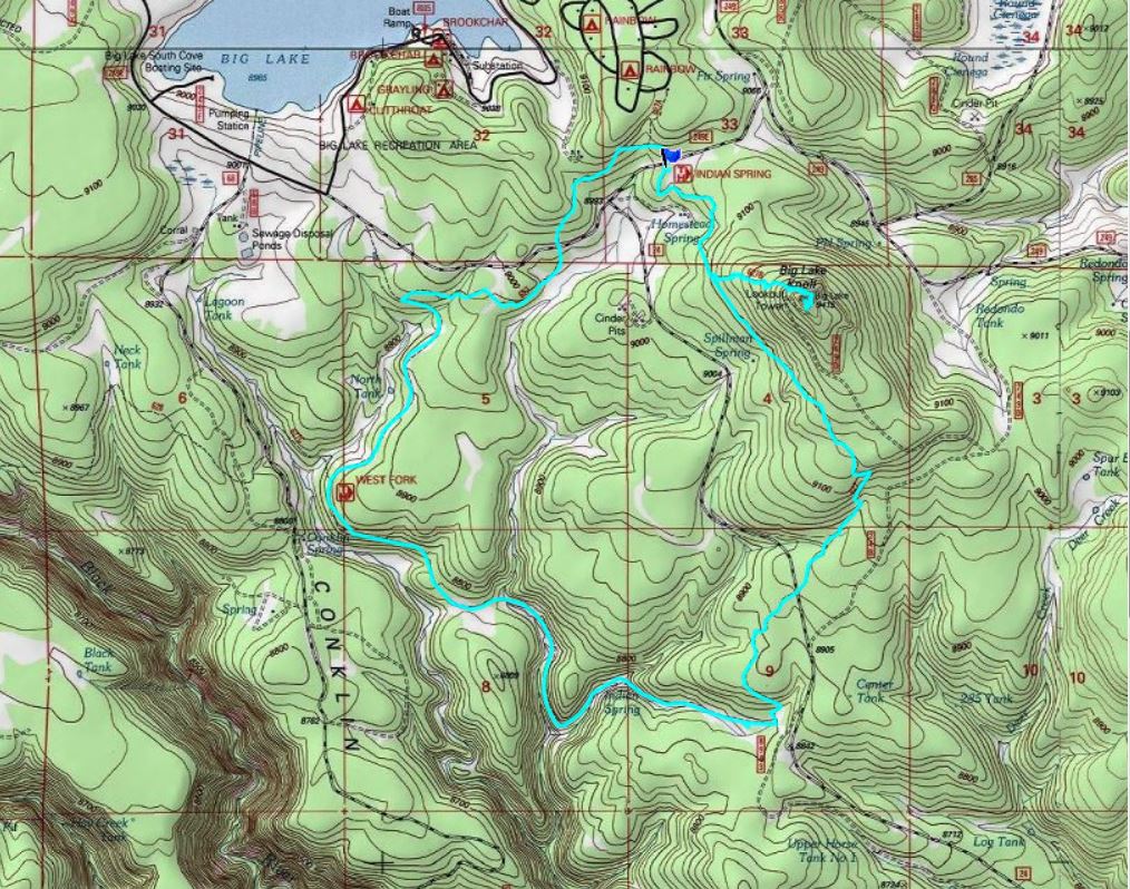
Day 3: Big Lake Look-about:
Day 4: A very Little East Fork of the Little Colorado:
to Mt. Baldy (limit of trail, reservation boundary); 13.5 miles; ERM = 20.5.
While writing these notes, a young Downy Woodpecker
undulates to the tree where I am sitting and grabs bark a few feet above me. She looks
at me upside down, and that's probably the way I appear to her. It's quiet time in Winn
CG after a short investigation of the camps and THs near Big Lake, a puddle of blue in
a stark and open meadow. It's now Saturday, and Winn seems to have lost population - to
3 campers. Fine with us. The bovine intellects (cows this time) have mostly been herded
away, and don't interrupt the quiet with their proclamations that they are better problem
solvers than tea-baggers. Moo-belch-ooo-moo-ooo.
We enjoy a grand nap swaying in the hammock, buffeted
by gusts of early afternoon wind. Cozy, romantic, and deluxe.
The volcanic pillowed spires jut above the Aspens and firs,
seeming to scrape the sky a bit. The proper sky scrapers. Yet, we don't see any sandstone, as
the FS trail guide says. We've crossed the tiny E. Fk, of the Little Colorado to see Shooting
Stars before climbing above the meadow and to and through the spires. Two sets of bear tracks
are pressed into this very dusty trail - a tiny cub and probably, the mom. Parry Primrose appear
about the time more blow-down trees do - yet the obstacles are certainly not as horrid as on
Day 2. Most jumbles, we walk around or crawl under without issues. We also see remains of an
airplane, perhaps part of a wing? At almost 7 miles, we encounter the trail from the West Fork.
A spur leads to the summit of Mt. Baldy - yet it's on the Apache Reservation and off-limits
because of spiritual splendor. So, we call off the leisurely climb at about 11,200'; the TH
is about 9300' Mt. Baldy is 11,400'.
As we contour back toward the volcanic spires, we see a
copper-topped structure on the ridgeline across the bowl. What? Probably the top of a ski
lift on Sunset Peak. Poor neighbors to the environment (pollution, erosion, disruption of
Winter range and migration corridors, etc.), ski areas are a wart on our public lands.
We're back in Winn CG, at about 9200', and it's time for a
sun shower and appetizers and beer. Yum. The air cools rapidly as sunset approaches, and
three layers of clothing is just right.
Day 4 photos - East Fk Little Colorado


Day 5: Scorched Earth - tea-bagger denial:
Indian Springs Loop near Big Lake; 9 miles; ERM = 13.
The fire-blackened singed dust poofs around boots as
we approach Big Lake Lookout. The LO is gone - yet part of the superstructure remains,
and from the high point one looks out over a black ghost forest. Climate change coupled
with tea-bagger/religionist denial of science and starving of our government (e.g., sequester,
etc., essentially no money for fire prevention - what money there is gets shunted into
fighting the catastrophic fires; continuing the spiral of poor forest health) have resulted
in the toasting of many acres of public land. Sure, fire is an essential ingredient in
healthy forests, yet not at the scale we are creating.
The trail continues through the ghost forest, eventually
passing some historic water troughs at Spillman Spring and then more baked trees, locating
some only singed and good for shade and a snack. Continuing down the meadow, we surprise
a cow elk cooling off in a tiny pond. She thunders out amid a spray of mud and water and up
a hill, stopping to display her tawny butt before melting into the trees. The developing
drainage is bisected by a causeway for the (long retired) Maverick spur of Apache Railway
and we join this route (no rails or ties) as we climb back up the bench. Circling back
through greenery, we complete the loop. We are the only campers in our CG loop tonight.
| ||||
 |
 |
 |
 |
 |
 |
 |
 |
 |
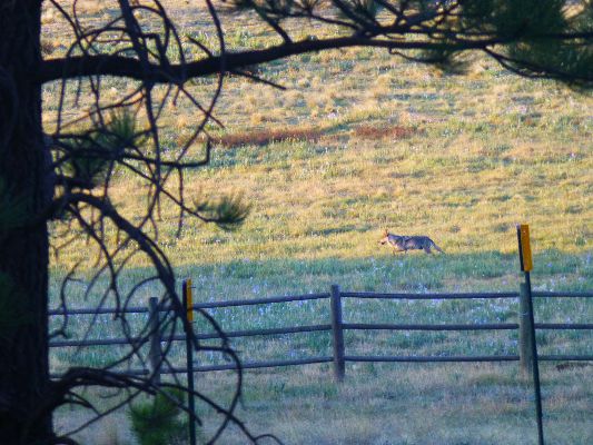
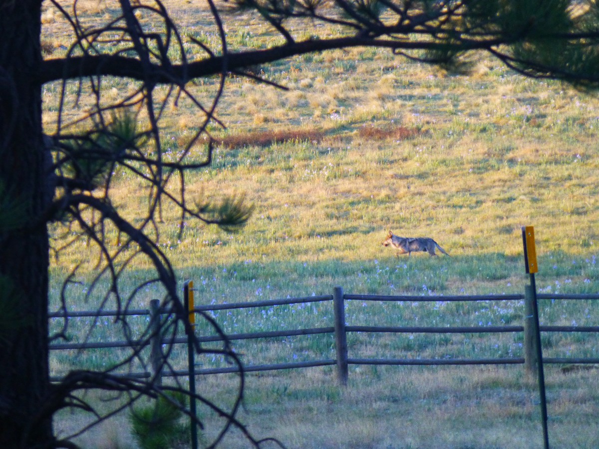
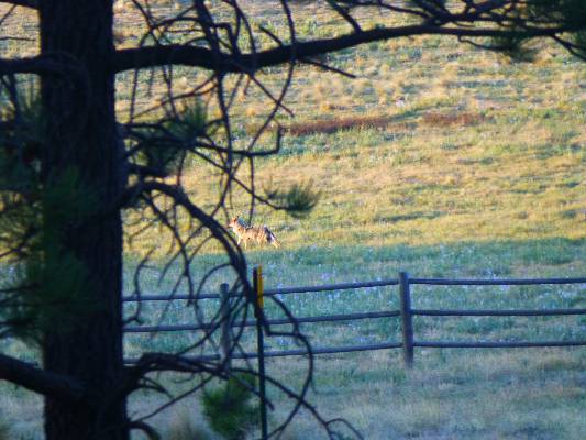
Day 6: Lobo Grande! Lobo Linguistics:
Sustained, soulful howls awakens us in the crepuscular
time. "What! a Coyote?" asks Kathleen. "That's no Coyote" I quip, then get up, put on
sandals and go toward the sound with my camera, intending to get an audio of the eerie,
wild, haunting, yet homecoming sounds of Lobo linguistics. The howl dwindles, then stops.
I'm standing at the edge of a meadow, wearing sandals and rapidly cooling in the morning
stillness. Then, the howl resumes and I see some movement out in the meadow. El Lobo!
A Mexican Gray Wolf! Like a giant reddish Coyote, the Wolves appear. I try for a brief
video, at distance. Wow! What an amazing way to conclude a Lobo Linguistic exploratory
of the White Mountains.
How lonely is the night without the howl of a wolf.
*ERM: Energy Required Miles, are there data to support this
mileage adjustment?
Journal of Outdoor Recreation, Education and Leadership
Petzoldt first proposed his theory in his 1976 book “Teton Trails” to
help backpackers plan trips and calculate their energy needs on mountain trails. “Petzoldt defined one
energy mile as the energy required to walk one mile on the flat. He recommended adding two energy miles
for every 1,000 feet of elevation gain, so a person hiking one mile and 1,000 feet upward would use the
equivalent of three energy miles,” Phipps said.
Petzoldt’s energy mile theory was just a reflection of the mountaineer’s
“gut feeling,” Phipps said. The theory had never been tested in a laboratory before the study began in WCU’s
Exercise Physiology Laboratory in the spring of 2010, Phipps said.
To determine the validity of the theory, the study measured the energy cost
and perceived exertion for walking on flat ground, with and without a 44.5-pound backpack, and up an elevation
gain of 1,000 feet, with and without the backpack, through the collection of metabolic data, Phipps said.
Twenty-four student, faculty and staff volunteers, including 12 males and 12
females, went through four testing sessions as the research continued into fall semester of 2010. The study
results showed that the additional energy cost for ascending 1,000 feet ranged from 1.34 to 2.02 energy mile
equivalents, for an average of about 1.6 miles, compared to Petzoldt’s use of two energy miles for each 1,000
feet. The range revealed by the study was due to the “hikers” personal weight differences, Phipps said.
“It is remarkable that Petzoldt’s energy mile theory is so close to the actual energy cost measured during our
study,” Phipps said. “In the field of outdoor education, it’s important for leaders to include an estimation
of energy requirements during the planning of hiking trips.”
Phipps said the energy required for hiking up steep mountain trails would vary
for individuals and groups, and the variables of the trail would also factor in, but he recommends that
backpackers stick with Petzoldt’s idea of adding two energy miles for every 1,000 feet of elevation gain when
planning trips.
The Validity of Petzoldt's Energy Mile Theory, 2010
Authors: Maridy McNeff Troy, Maurice L. Phipps
Publication: Journal of Outdoor Recreation, Education, and Leadership
Books:
Eaarth : making a life on a tough new planet, McKibben, Bill,
Time Books, 2010.
Maybe one : an environmental and personal argument for single-child families, McKibben, Bill, Simon & Schuster,
1998.
The end of nature, McKibben, Bill, Random House, 1989.
An Important Link:
| |||||
| |||||
| |||||
| |||||
| |||||
| |||||
| |||||
| |||||
 |
 |
 |
|
Wild Vagabond Main |
Trip Report Index  |
Caveat  |
|---|