(Click the image for a full-size view (17k); Photo by Rob)
*The title is an adaptation from Omar Khayyam's, Rubaiyat.
|
|
|---|
|
Looking South across Liberty Lake from the pass trail
(Click the image for a full-size view (17k); Photo by Rob) |
|
Wild Vagabond Main |
Trip Report Index  |
Caveat  |
|---|

| ||||
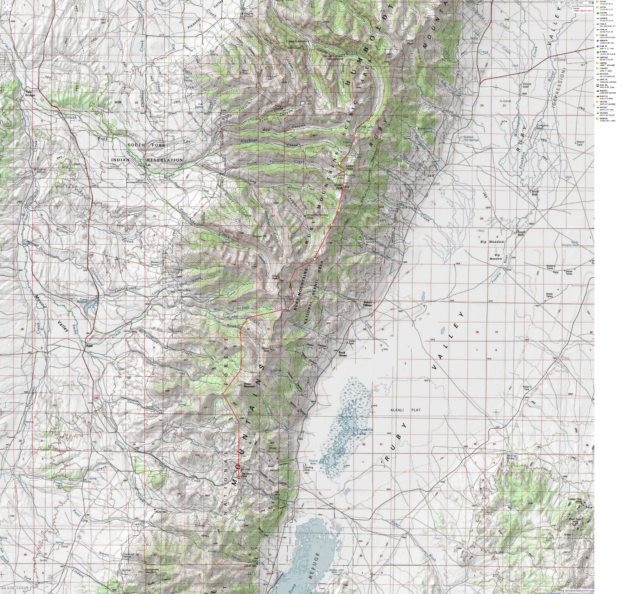
If you want to view a full-resolution map, click here. Caution - do not use this map or gps track for navigating the route.
Summary: This is a report about a through-hike of the Ruby Mountains Crest Trail, from Harrison Pass to Lamoille Canyon. The total trail distance is estimated to be 44 miles. However, the total EMR (Energy Required Miles, based on Paul Petzold's idea of adding a mile for each 1,000' of elevation gained or lost) is approximately 58. So, be prepared for an undulating roll through the backcountry on this, the Consummate Rubaiyat Crestival!
Background: See the 1995 and 1998 Ruby Mountains trip reports and the links and references below for background info. Note that, outside snowbanks (if they have not melted), there is no water between Furlong Lake on the North and the cirque below Kings Peak - a 14-mile or so trudge.
Be advised, that the FS appears to have little knowledge about conditions on the Crest Trail, outside the overpopulated Northern lakes area. When I called the FS just prior to going on this trip, I was informed that the section from Harrison Pass to Overland Lake was deemed to be "dry." This was a Newt Gengrich of the truth: an inadvertent misstatement of the truth, a partial statement of the truth, an unforseen omission of details essential to the truth.... well, you've heard Newt, so you've heard all you don't need to know. The truth seems to be that the FS invests little in trails and backcountry, and really has little clue where the trails are or what you might find. (See the 1995 report, if posted on the Idaho Alpine Club site (see links page), for a spectacular example.)
For info contact:
Ruby Mountains Ranger District
428 South Humbolt
P.O. Box 246
Wells, Nevada 89825
800-764-3359, or
Please do something wild. Take action to protect the Ruby
Mountains Wilderness and other wonderful areas. Consider writing today, and start your
quest with a visit Friends of Nevada Wilderness.
Dr. Art Snoke, a geology professor at the University of Wyoming, has written
several accounts of Ruby Mountain rocks. For those of you wanting some substantial
background about Ruby rocks, please see: Mueller, K. J., and Snoke, A. W., 1993, Progressive overprinting of normal fault
systems and their role in Tertiary exhumation of the East Humboldt-Wood Hills metamorphic
complex, northeast Nevada: Tectonics, v. 12, p. 361-371. Wright, J. E., and Snoke, A. W., 1993, Tertiary magmatism and mylonitization in the
Ruby-East Humboldt metamorphic core complex, northeastern Nevada: U-Pb geochronology and Sr,
Nd, Pb isotope geochemistry: Geological Society of America Bulletin, v. 105, p. 935-952. "...with Nevada these high, discrete, austere new ranges begin to
come in waves, range after range after north-south range: basin, range, basin, range; a mile
of height between basin and range." (McPhee, 1980, pg. 18). If you want to read what may be
the greatest non-textbook about Western geology, I refer you to: McPhee, John (1980),
Basin And Range, New York: Farrar Stauss Giroux.
702-752-3357
The ruba'i, plural rubaiyat, is a two-lined stanza of Persian poetry. Ruba'i is an Arabic word meaning "four-some." It was a very popular form of poetry in the 11th and 12th century in Persia. The first, second and last of the four hemistiches must rhyme, while the third does not need to rhyme with the other three. If you see a rubaiyat preceded by a number, it is from Omar Khayyam's, Rubaiyat as they relate, ever so obtusely, to the content of the trip report. Rhyming is not complete, because the rubaiyat have been translated from Persian. The numbers indicate the rubaiyat as numbered by translators. Enjoy.
The Day: I started from Smog Lake mid-morning and headed across the brilliance of the salt flats, leaving Utah, gateway to Nevada. In Nevada, I left I-80 at Halleck and drove the back route to Lamoille, the town, and to the Lamoille RS. , lt NF. After some rain, some late lunch, some more packing, I drove up Lamoille Canyon, where I dropped off my car. It rained hard in this "little Yosemite" valley. Dodging rain, I shuttled all the equipment into another treker's car and headed back down the canyon and around the Rubys through Jiggs to Harrison Pass, finally driving up the Ruby Crest Trail about .5 miles before being stopped by a steep hill.
I debated hiking, but because it was late and because of concern about finding water along the trail, I camped. And, I bagged a large quantity of trash from ORV grunge-campers before settling in to watch the final sunglow.
Day 2: Strain and Gain 1: (Harrison Pass to McCutcheon Creek; 9 miles, 11 ERM.) Commentary: The egg yoke sun turned a blood red as it swam through a yellowish gray meringue. Dim light with the cast of an eclipse dimmed the shadows. What is going on? I had seen a fire far across the valley, and now there was evidence of one South of me, perhaps rolling through the dry grasses of Harrison Pass. I wondered if I needed to race up to the ridge and check. Instead, I settled back to lounging in my 8760' camp near McCutcheon Creek, where the creek burbled through the bogs, supplying Elephanthead, Monkshood, Monkey Flowers, Mules Ears, Paintbrush, Bluebells, and lots more flowers, along with me. I have lots of luscious water in my small cirque, and it's been a delightful day.
The Day: I trudged up the jeep road, which continued far past where the trail should have been. ORV mechanized assholes have destroyed the trail. No wonder few visit this part of the crest. The trail finally began, almost at the wilderness boundary.
Snow-leaner trees thwarted my progress as I continued to contour around Green Mountain. Trudging up the trail, I was shocked to be looking, at eye level, across a diminutive lake. What? The trail disappears into the edge of this elevated lakelet. One of those wilderness engineers, commonly called a Beaver, had constructed a dam and a house on one of the tiny side streams crossing the trail.
Camping was marginal along the trail, but I enjoyed the delightful flowers and the Aspens. I've been on the Harrison Pass, Franklin Lake SW and NW quads, and now I'm on the Green Mountain Quad.
Day 3: Overly Dead; or, Black Ghost; or Strain and Gain 2: (McCutcheon Creek to Overland Lake; 9 miles, 12 ERM.) Commentary: The low-to-the-snow black ghost darted across the precipitous snowfield, from granite jumble to marble with granite intrusions outcrop midway down the top of the Overland Lake Cirque. I blinked my heavy eyelids and tried to muster enough energy to open them wide enough to evaluate the ghost. The body systems are working, but slowly. I strained to see where the ghost might reappear, somewhere a few hundred feet below in the amphitheater of the cirque, but I saw nothing but the tumbling snow melt and the distant wind ripples on the pondlet above Overland Lake. By now, I had the binocs out and was looking, but saw nothing, so I started scanning the ledges for Mountain Goats.
The Day: It was a difficult day of gaining and losing altitude, and it seemed in excess of the 12 ERM I later estimated. I started with climbing out of the McCutcheon drainage to a low ridge at 9440, then dropped into South Fork Smith Creek at 8120, then immediately went up and over a bump into Middle Fork Smith at 7900, from which I began the long crawl adjacent to North Fork Smith, ending with a sharp upward climb to a pass between Smith and Mayhew Creeks (9800 at the pass). But, I found the route continuing to 10,160 at the lip of the Overland Cirque. Already inching along and totally fatigued, I crossed snowfields on both sides of the lip.
I collapsed after relocating the trail at the top of the cirque, but lucked out with a glimpse of the black ghost. The clouds were darkening, and a few drops of rain splatted in on the strong November winds in this alpine country. Trudging down the last snowfield, I completed the puzzle when I saw the fresh tracks so nicely outlined in the snow. A Wolverine! The black ghost was a Wolverine! No wonder my attempts to imagine a funny-shaped Coyote, etc., had failed. What a prize to see this elusive call of the wild.
I hobbled to Overland Lake (9453), where my feed said they could would go no farther. I had initially hoped to continue on a ways, to get set-up for the Crestival. However, I greatly enjoyed the marbled granite and intruded feldspars and micas imbedded in out boulder camp above Overland Lake. The clouds cleared out and I enjoyed a muted sunset while gazing out to distant crop circles caused by those giant water-sucking irrigation center-pivots far below and out in what used to be the Ruby Marsh.
Day 4: Recoupe de Cirque: (2 miles, 2.5 ERM.) Commentary: The trout paused in the transparent waters of the Overland Lake outlet, eyeing the vivid purple and yellow of the Shooting Star and the magentas of the Elephanthead flowers dangling like a fishing lure from the boggy area, then continued on its search for edible bugs. It's a day for contemplation and recoupment.
The Day: I arose late and explored the cirque a bit, then packed to head down the trail a few miles. At the old cabin by the lake I met Kelly and friend Richard Lovett, the first people I have seen since saying good-bye to the trailhead. We talked of the long, high, and dry with poor camping possibilities stretch of the Crestival, estimating it's at least 14 miles to the North Furlong Lake junction. We had all heard assorted estimates of this distance, and estimating it from the map was difficult because of the numerous squiggly switchbacks and such.
I later saw Kelly and Richard after I had walked to the gorgeous cirque I had found last year on the blitzkrieg hike of the Crestival, and after I had enjoyed a warm shower and more lounging.
Day 5: Rubaiyat Crestival! (Cirque to North Furlong Lake, 14 miles, 18 ERM.) Commentary: Looking up from my head-down plodding up the trail, I saw a billion points of sparkle, a true geologists' dream, as the low-angle early morning sun light glinted off the facets of marble, two-mica granites, and twinkling feldspar in the outcrop ahead. Flanking the outcrop glow the bright yellows of Arrowleaf, the reds of Paintbrush, and the iridescent cyan and royal purples of Lupine and Penstemon. It's early and I'm marching over the long, dry stretch to North Furlong Lake. The trail climbs directly over four summits as it rolls the ribald, raucous, Rubaiyat Crestival!
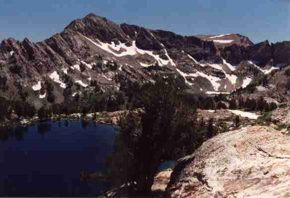
The Day: I got up at first light, then left my lovely cirque and headed up toward the first Crestival bump at 10,207', where I again encountered Kelly and Richard, and talked of strained knees and writing about this wondrous country. It's balmy on this early Crestival day, and a Red Tail hawk enjoys it along with us, sailing just below us on the thermals beginning to rise from the flats off the East side of the crest. Today I would do better with hydration and energy, stopping on every peak for food and water and a foot break. I slogged on, over peaks 10,756 and 10,760, and finally to Wines Peak at 10,893'. It's open country up here and I saw long views way back South to Tipton and Kings Peaks and to Green Mountain, and up ahead to the long side ridge where Ruby Dome and other hulks reside.
I lounged out of the wind on Wines Peak and compass-sighted the pass into Favre Lake, etc. Then, I cruised down the broad flank of Wines to tree line, and then the .7 miles into North Furlong Lake. Here, I invested over an hour cleaning a grunge horse camper camp (bailing twine mutilating trees, trash in the fire pit, etc.) before a refreshing dip in an inlet to North Furlong. I ran up the handkerchiefs on the bear line as a flag, in case Kelly and Richard wished to share this spacious, and now quite livable, camp. Kelly came by, chatted for a short while, and that was the last I saw of this duo. And, ahh, I relished my easy recovery from the Rubaiyat Crestival!, savoring my recent memories of this undulating wilderness.
Day 6: Lake Lounger: (North Furlong Lake to Roads End - Lamoille Canyon TH, 10 miles; 14 ERM.) Commentary: The tracks were large, a big split-hoofer had passed this way, I concluded, eyeing the cobalt water of Favre Lake in the basin ahead, and distracted by the beauty of the cirque. Perhaps I would see the moose I hoped for. I noted that the split-hoofer tracks were on top of all the hikers' tracks from earlier today. Humm, they are close by. I plopped down for lunch in the shade of a large conifer. Almost in a torpor, I noticed movement between bites of my last lunch scraps. A deer was crossing a snowfield where only goats belong. What is she doing there? Perhaps she is on a short-cut route to Castle Lake, in the bowl high above us. After lunch, I got back on the trail, and began to follow the big mooses, for clearly there were two. Wait. These moose tracks have the marks of toenails in front. What? Well, fool me once, shame on you, fool me twice, shame on me.... I had been fooled the first time I saw tracks like this in the High Uintas, where I followed them for half a day pondering what could have made them. But no more. They were clearly llama tracks. Two llamas, following two people. So, I would not see a moose today. Sadly, the llama group left the trailhead before I saw them.
The Day: The day started with a brief cross country excursion to the pass above North Furlong. Here I began seeing people. I wandered past lakes, Favre, Liberty, then over Liberty Pass (10,450') from the easy side. Here I really began to feel like I was in a propagation day parade on July 24th when I was met by over 20 huffing youngsters on a field institute maneuver. Down and down I hiked, past Lamoille Lake, then the Dollar Lakes (quarter, half, one-ten dollar...). At about 8,500', with somewhat flattened feet, I rambled out onto the tarmac of the Road's End TH, finishing the Consummate Rubaiyat Crestival!
With flat feet, I drove down the Little Yosemite valley, passing a grinning Badger and some young Red Tails showing off for the infrequent tourists. Over at the Lamoille FS station, I stopped and prowled around. No anyone. So, I enjoyed a garden hose shower in the back grounds of the station and proceeded toward Secret Pass, which passes between the Ruby and the East Humboldt Ranges. . I continued past Sandhill Cranes, and a large variety of raptors and Corvids pretending to be raptors, then joined the highway and looped back to Wells. Following a "light" breakfast as the sun set, I lost, won, lost, lost to break-even in the restaurant casino before continuing back across the salt flats to Smog Lake, luxuriating in my memories of the Consummate Rubaiyat Crestival!
152. These few odd days of life have passed
|
Wild Vagabond Main |
Trip Report Index |
Caveat |
|---|
|
|
|---|
|
One of the last views of Liberty Lake from the pass trail
(Click the image for a full-size view (17k); Photo by Rob) |