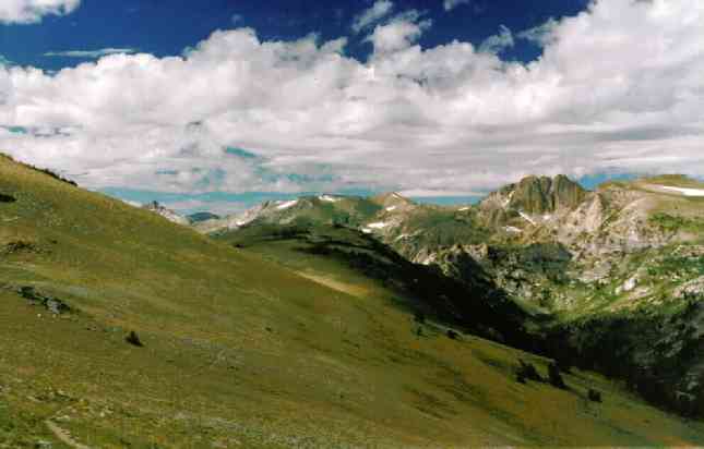
(Click the image for a full-size view (19k); Photo by Rob)
*The title is an adaptation from Omar Khayyam's, Rubaiyat.
|
|
|---|
|
The route alonge the Ruby Crest
(Click the image for a full-size view (19k); Photo by Rob) |
Background: See the 1995 Ruby Mountains trip report for background info. You can now call the Wells FS office (Ruby Mountains Ranger District) on a toll-free number. It is: 800-764-3359. Road summary: It's 207 miles from Smog Lake, UT to Wells, NV. Then, you travel south for 29 miles on Hwy. 93, turning toward the Rubys onto Hwy. 229 and traveling about 13 miles to an intersection, then the last leg, south again, on Hwy. 767 for 15 miles. The last part of this section is on gravel. Watch carefully, because the trailhead is poorly marked, although there is a frail BLM sign noting, "Overland Lake, 8 miles." Note that, outside snowbanks (if they have not melted), there is no water between Furlong Lake on the North and the cirque below Kings Peak - a 14-mile or so trudge.
For detailed info contact:
Ruby Mountains Ranger
District
428 South Humbolt
P.O. Box 246
Wells, Nevada 89825
800-764-3359, or
702-752-3357
"...with Nevada these high, discrete, austere new ranges begin to come in waves, range after range after north-south range: basin, range, basin, range; a mile of height between basin and range." (McPhee, 1980, pg. 18). If you want to read what may be the greatest non-textbook, popular portrayal, about Western geology, I refer you to:
McPhee, John (1980), Basin And Range, New York: Farrar Stauss Giroux.
The ruba'i, plural rubaiyat, is a two-lined stanza of Persian poetry. Ruba'i is an Arabic word meaning "four-some." It was a very popular form of poetry in the 11th and 12th century in Persia. The first, second and last of the four hemistiches must rhyme, while the third does not need to rhyme with the other three. I have inserted rubaiyat from Omar Khayyam's, Rubaiyat as they relate, ever so obtusely, to the content of the trip report. Rhyming is not complete, because the rubaiyat have been translated from Persian. The numbers indicate the rubaiyat as numbered by translators. Enjoy.
153. Before
you and I did, night and day existed,
The revolving
heavens were busy;
Where you
set your foot on the face of the ground
Was the
pupil of the eye of a sweetheart.
And, so begins my third brief trek into the Ruby Mountains, one of the many Nevada cordillera.... Alas, it was a solo trip, and about this sort of thing Omar says:
219. To
be content like a vulture with a bone
Is better
than being the uninvited guest at nobody's feast;
To be with
your own barley bread is certainly better
Than to
be polluted by the confections of nonentities.
|
Wild Vagabond Main |
Trip Report Index  |
Caveat  |
|---|
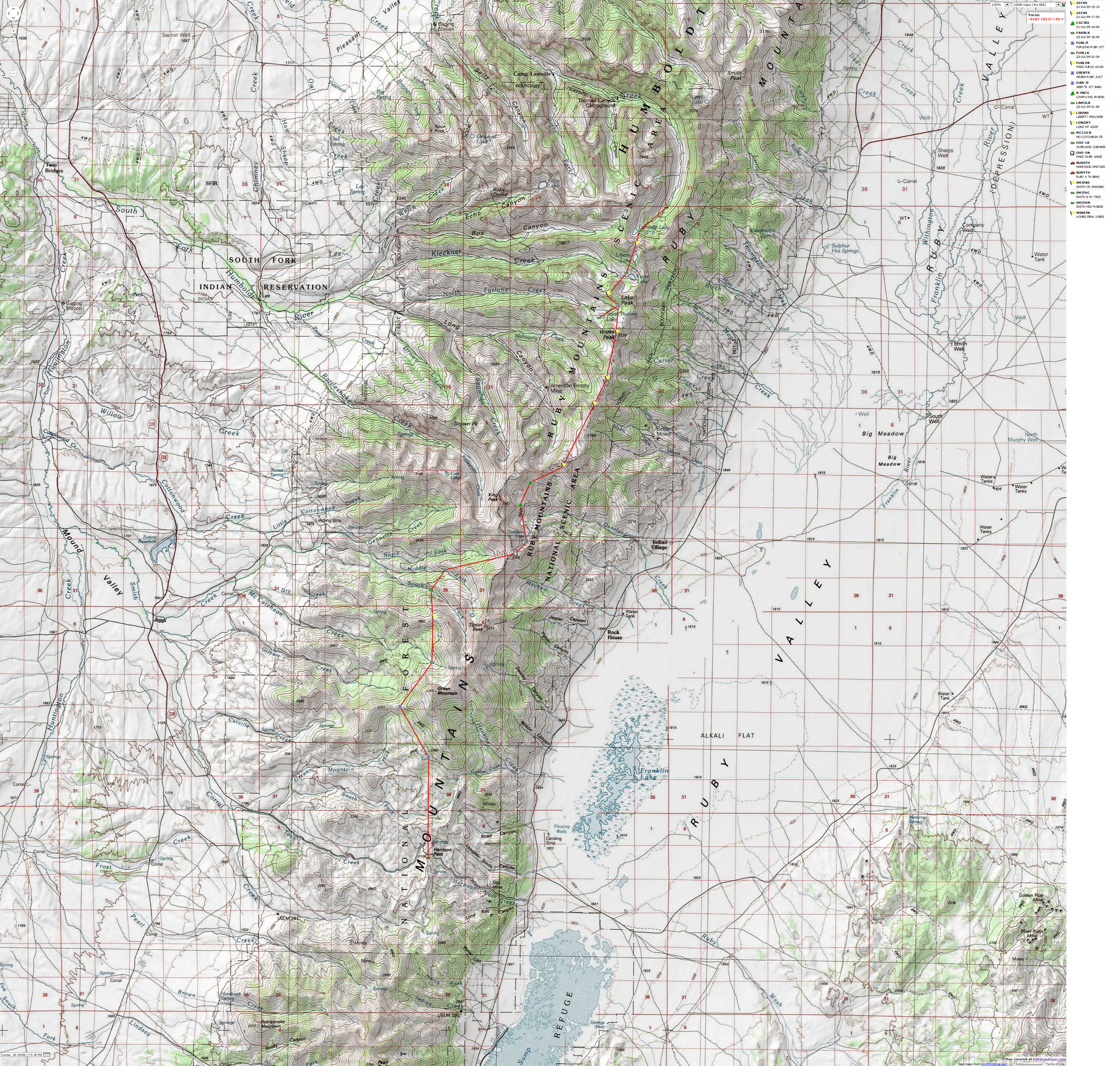
The map below was constructed from waypoints obtained during the 1999 Ruby Crest backpack. They are strung together to make a route (not a track). This map is posted here to provide visual information about hiking The Ruby Crest. Enjoy.

| ||||
If you want to view a full-resolution map, click here. Caution - do not use this map or gps track for navigating the route.
Day 1: Rubescent Rubys: I made it to the Rubys as the sun glowed rubescent. The granite and quartzite teeth projecting from the west face of the mountains turned a rubiginous (rust-colored) red as the sun's rays filtered low-angle across the expansive Ruby Marsh, now in the distant dusty bowl below. Twilight twinkled off mica and feldspar flakes imbedded in the craggy teeth. Over a thousand feet below, I could see widely-scattered farm lights twinkling, these lights popping out like the stars above in the crystal air. Somewhere down there was Geology Jones from the University of Wyoming, who had given me a ride to the upper trailhead (TH). He is re-mapping the geology in this part of the Rubys, and striving to finish his college degree.
I got a late start, and arrived at the TH in late afternoon. As I was getting ready to begin the hike, Jones (no relation, outside our wilderness-wandering proclivities) arrived and gave me a ride. Mineral guides, sample bags, coffee cups and various implements like rock hammers slid around my feet and across the seat as Jones prodded his pickup up the steep grade. We talked some about plutons and batholiths, and then I headed up the trail, hiking less than two miles before full dark caved in just as I reached the Mountain Mahogany vegetation zone and the wilderness boundary. I threw up my tiny Marmot bivi sac as the third billion stars arrived. After gulping some items from my lunch bag, I went to sleep. A phantom wind woke me, and I was awake long enough to enjoy the brilliant black night stars.
15. A bull
is next to the Pleides in the sky,
Another
bull is hidden below the earth;
If you're
not blind, open your eyes to the truth,
Below and
above the two bulls is the drove of donkeys!
Day 2: Cirquedom: (8 miles, 2000'+) It's spring along the unnamed tiny creek in the cirque below Peak 10,841 and the sheer ramparts of King's Peak (11,031'), about a mile onto the Ruby Crest Trail from the Overland Lake junction. Monkshood, Elephanthead, Yarrow, Penstemon, Cow Parsnip, Paintbrush, Columbine, Lupine, Shooting Stars and lots of others for which I didn't know the names grace the narrow riparian ecosystem bordering the cirque's stream.
63. All
the plants that grow beside the stream
Have surely
grown from angel's lips;
Tread roughly
on no plant,
For it
has sprung out of the dust of the tulip-cheeked.
It's late afternoon and I'm a bit cold, despite pants and a pile jacket. I may regret traveling as a minimalist this trip. The big fluffy clouds have not paused to rain on me (yet) and this is a good thing, because I brought the Marmot Burro (a one-layer bivi-sac) rather than a true tent. I'm camped in a wind-shearing island of Limber Pines (5 needles to a group, flexible branches, cones up to about 4" long). It's an excellent camp and not very obvious from the trail 60 or more vertical feet below. Four deer paraded by at dusk. I did not see any people today. But, I did find lots of mica, imbedded in quartzite outcrops, so much that the hillside glittered like Liberache's rhinestone cape when struck by the sun's rays. It's a great place for contemplation, bounded by the sheer ramparts of Kings Peak and the cirque, the expansive Ruby Marsh 3000' below and miles distant - if it weren't so cold. I felt a bit better after I ate some dinner, replete with fish steaks, ahh, lots of yummy fat. What a lovely cirque!
43. It is
a bowl the Creative Reason casts,
Pressing
in tenderness a hundred kisses on its brim;
This cosmic
potter makes such a rare bowl,
Then throws
it back again to the ground.
Day 3: Rubaiyat Crestival: (22 miles, 11 hours, 4 peaks) Today, I hiked the Ruby Crest Trail, North to Wines Peak and back, traversing 3 other peaks along the way, twice.
I'm sitting, nearly comatose, on a polished Limber Pine log as the last remnants of the sunset imitate alpenglow on the West face of Kings Peak. I have managed to start the stove and a tiny Limber Pine wood fire and hobble down to the stream to get water for the first course of tonight's dinner, soup and whatever else I can find. Now, I'm wondering if I can muster enough energy to become less of a bump on a log and take a handkerchief bath in the stream before serious dark sets in. At one with the log, I can hear what must be climbers on Kings Peak. "Hey Clarence, do you smell the fire?" the voice floats down, muffled by the drone of the maidenhair cascades as the streamlet of snow melt stair-steps over the verdant ledges and into the lower cirque. Another, much closer female voice seems to say "What's cooking, what's for dinner?" I crane my neck to see where the voices originate, shocked by how close they now sound, then, Yikes, I catch movement in the periphery of my vision, right at the edge of the forb-forest and grass carpeting the edge of camp. The brief adrenaline rush subsides as I see that it's a troop of Spruce Grouse talking their grouse-talk to each other as they strut a circle around my camp. I'm a bit relieved that I'm not any crazier than I previously suspected. My next thought is "I wonder if I can eat two or three or four of these fat, tasty, self-baster, pre-seasoned, delicious grouse?"
150. Oh
heart since time's passing grieves you
And your
pure spirit so unseasonably leaves the body,
Sit on
the green, spend a few days in happiness
Before
the green grass springs from your dust.
I began marching fairly early, leaving camp in place. Piercing winds prompted me to have my jacket on and off all day, with a canvas shirt and shorts as a minimum.
203. Get
up lad, it is dawn,
Fill the
crystal goblet with the ruby wine;
In this
hole and corner of transience you will seek this borrowed moment
Long and
never find it.
Over Peak 10,207 first, where I paused on top, hiding from the wind in a rock shelter and sipping filtered snow water. The trail then drops down several hundred feet before climbing, again, to Peak 10,756, rolling on to and over Peak 10,777, and finally to Wines Peak at 10,893'. Straight-line it appears to be about 7 miles. With switchbacks I guessed it was close to 11 miles, one-way. Then, there is the elevation gain and lost, the energy-required measurement over these bumps. Whew, I paused for gorp several times. I encountered a couple from Reno who had hiked from Furlong to Overland Lake yesterday, and were on the trudge return today. The woman said it was "too much", probably 14 miles each day. They, like me, had wanted to hike the whole Crest Trail, but had not overcome the logistic problems (questions about water availability, and, mostly, how to get a vehicle shuttled to Harrison Pass from Lamoille Canyon). I also encountered a hey-girl being from California as I began the switchbacks to Wines Pk. She reported that she had forgotten the "spigot in the fuel bottle to my stove" (the pump, I eventually determined), but that "I have a print-out of all the water sources in the mountains." And, she had only the barely-useful forest district map for guidance, except for the "print-out" of course. I marveled at how the thunderbolts of Darwin's theory seem to miss such obvious targets. The hey-girl wandered off along the Crest, and I continued to Wines Pk.
Rolling, trudging the Crest, afforded views of Long Canyon, the jagged peninsula holding Ruby Dome, the tundra-like carpet dotted with yellow blots of Cinquefoil and Buttercups, blue dashes of Lupine, and the green islands of wind-weathered Limber Pine. Looking back, South, there are views of toothy Kings Peak, the lone incisor of Tipton, and the distant looming mound of Green Mountain.
I walked out on the broad peak East of the Crest Trail to find the USGS monument celebrating the summit of Wines Peak (10,893'). With a touch of the monument, I had officially hiked about two-thirds of the Crest Trail, in segments, from Lamoille to the pass above Overland. Only the stretch from Overland to Harrison Pass remains unhiked.
22. If only
there were occasion for repose,
If only
this long road had an end,
And in
the track of a hundred thousand years, out of the heart of dust
Hope sprang
again, like greenness.
Day 4: Overland, Out: Initially, I was planning to explore south from Overland Lake toward Green Mountain. But, today I quickly visited Overland Lake, then I dropped back to the vehicle via the Overland Lake Trail, picking up several foot-flattening schists and quartzites with mica inholdings along the way.
41. There
was a water-drop, it joined the sea,
A speck
of dust, it was fused with earth;
What of
your entering and leaving this world?
A fly appeared,
and disappeared.
As the engine revolutions eclipsed 3200, relating to 90 mph on the hills, my trusty Subaru whined away the surveyor-straightness of I-80 across Nevada and into the land where polygamists roam free, rampantly breeding in a seeming race toward overpopulation of our only planet, a land where those with "overly-liberal" ideas are prosecuted, I had the displeasure to witness the "harmless steam" emitting from the MagCorp stack. Mag-Corp is the nation's largest-volume air polluter, and good neighbor to Utah republicans. MagCorp, like all good large-money, large-pollution, lobbyists, insist that they are good for the economy and your health.
152. These
few odd days of life have passed
Like water
down the brook, wind across the desert;
There are
two days I have never been plagued with regret for,
Yesterday
that has gone, tomorrow that will come..........
(Please read the Caveat, visit the Wild Activist Links, and do something Wild today. Thanks.)
|
Wild Vagabond Main |
Trip Report Index |
Caveat |
|---|
