
|
|
|
|
|
(Jump back to the top of this report)
Prologue: We started at Sand Wash, SE of Myton, Utah and got off the river below Swaseys Rapid, which is 12 river miles upstream from Green River, Utah. This 83-mile stretch (River miles 95 to 12) is Class 1-3+ water. Because of work schedules, we floated the Deso/Gray in 4 days, made possible by the relatively high stream flow. The trip would probably be better, offer more hiking, etc., at about 5-6 days, and this amount of time would be required in low water. If you go, first check the USGS streamflow web site. Note that the Green River gauge, at the town of Green River, is downstream from a diversion dam that is just below where you take-out of the river. Also, note that the flow is partially controlled by the Flaming Gorge Dam, over 100 river miles upstream.
The USGS stream flow web address is: http://water.usgs.gov/public/realtime.html
Powell and crew were the first recorded people to boat this section, in June of 1869. Powell named the Desolation/Gray with the description from his river journals:
References:
Belknap-Evans, L.E. & Belknap, B., 1974 (reprinted 1996). Desolation River Guide, Westwater Books, Evergreen, CO.
Nichols, G.C., 1986 (revised 1993). River Runners' Guide to Utah and Adjacent Areas, University of Utah Press, Salt Lake, UT.
Desolaton Canyon Management Unit (BLM) info can be seen at: http://www.recreation.gov/detail.cfm?ID=1866
A BLM boat permit is required to float the Desolation/Gray. Craig River King McCarthy had performed the organizational work for us, but you should contact:
|
Wild Vagabond Main |
Trip Report Index  |
Caveat |
|---|
(Jump back to the top of this report)
|
|
Day 1: Bug-in at Sand Wash: It was raining and the wind was blowing when we met at the Wasatch Mountain Club boat shack at 9 a.m. to complete loading the trailer and vehicles. Previously, teams had worked to prepare equipment and food, lots of food. With what looked like enough equipment to outfit the Spanish Armada, we began the drive to Sand Wash, put-in to the Desolation/Gray Canyon section of the Green River.
To reach Sand Wash, one turns South off Highway US-40 (west of Myton, UT) between Mileposts 104 and 105. It's 47 tire-gouging miles to Sand Wash once you leave the tarmac. And, we had a flat tire, punctured by a toothy rock the size of a Tyrannosaurus incisor. Russ said "this is the high-point of the trip." It got a little better.
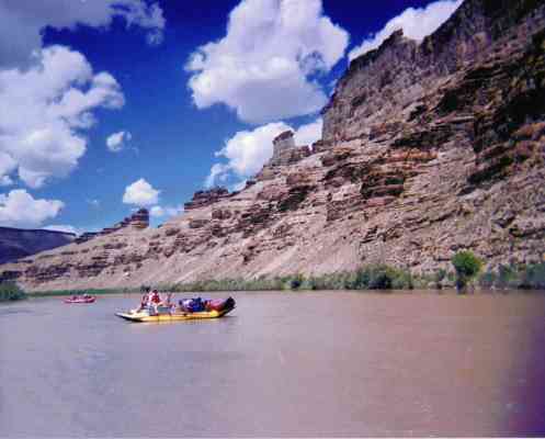
It was mosquito mayhem at Sand Wash. This high-point was punctuated by the dust squalls that filled our eyes and mouth with grit as we pumped-up boats and slapped mosquitos. We 19 would be floating with 4 oar-boats and 2 paddle-boats. The scrawl in the BLM screen-house reported that the river flow was 16,800 cfs, a flow that Craig said "will provide a good ride."
Dinner was an excellent combo of bratwurst, sauerkraut, potatoes, and rolls. Although offered copious quantities of wine, food, equipment, etc., Jim would not divulge the secret family recipe for the scrumptious sauerkraut. Because George and Kerry were late and had all the cooking equipment, we borrowed stuff from some Colorado boaters who were preparing to float. The wind continued throughout the night, and helped to ease the supply of mosquitoes. But, many of us dreamed, with trepidation, about rowing/paddling against the up-canyon winds for the first 26 river miles (RM).
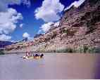
Day 2: Flatwater: (River mile 95 to 78; 17 miles). Today, we powered along the lazy flatwater section as the cliffs grew taller and more interesting. The first 26 miles of this trip are flatwater. It was intermittently windy, and the temperature was mostly warm. We got an early, by river time, (9 a.m.) start, and this helped us avoid some of the afternoon up-canyon winds. It was a day for gazing at rock, easing into river time, and developing a decent sunburn. For me, it was a day of helping to oar a boat, learning a bit more than I already knew about it.
I'm sitting on a packed-sand beach above the restless, gurgling river. The wind is still swirling in and out of the cottonwoods and tamarisk across the river, forming waves of green as it passes. We delighted in a little wine, a little conversation, with the background thud of George snoring in his tent. It's half-time in game 6 of the Jazz-Bulls NBA championship playoff, and some zealous fans have brought radios to listen to the game. This, and the number of watches in the group brought protests from those easing into river time. (The Jazz lost by one point, losing the series 4-2.) Jim displayed his support for the Bulls and was rewarded the next day with a super-soaking delivered by Carol and Ursula. Refreshingly, the radios and many of the watches disappeared after the game was over. Eileen went fishing for catfish, and caught one.
Holly felt that the highlight for the day was an approximation of river time settling in, and the concomitant fading of some of the daily trivia. We all thanked lead-boaters George and Kerry for quitting a bit earlier than planned, thus avoiding the building up-canyon breezes. Carol conducted the smooth maneuver, groover instruction after we appropriately set-up the portable toilet below a pot-hole arch during half-time in the NBA game. The mosquitoes were few and the spaghetti and salad plentiful as we played a unique washer-in-the-hole game akin to horseshoes. We enjoyed showers (from our sun-shower bags that had been warming on the oar boats all day) and the cooling, generally bug-free, evening breezes. Life is good.
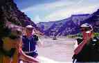
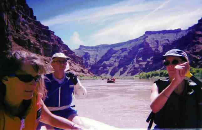
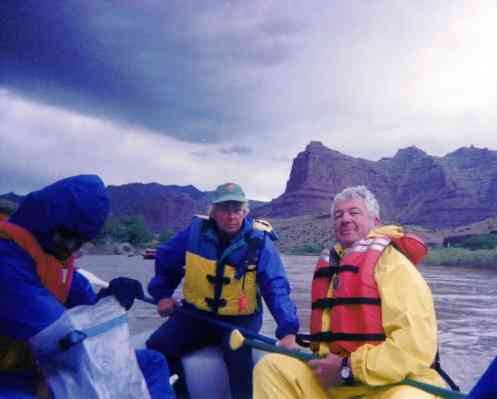
Day 3: A Snapping Day: (RM 78 to 52; 26 miles). Today, I am in the paddle boat captained by Craig, the River King. It is a wetter approach to touring the Green, especially in the front position. After flatwatering around Peters Point, we entered the Jack Creek Rapids (RM 70), then rapids in snapping succession, Big Canyon, Firewater, Cedar Ridge, Flat Canyon, Fretwater, Wild Horse, and the more difficult Steer Ridge and Surprise Rapids (RM 56), where rocks and hydraulic holes awaited. At times I found my head breaking the waves before the raft did. Captain Craig was quite efficient in coordinating the paddling efforts and reading river obstacles. Captain Maria took over and she also did a fine job, followed by some captaining by Ursula. My right arm and shoulder wore out, so Carol and I traded places. This produced some difficulties for the captains, because Carol had been compensating for the weak-side stroke of the captain with some special paddle strokes, and I was unaware of this. Paddlers in the two paddle rafts took turns mooning each other as we leap-frogged from potty stop to potty stop. It's amazing, when in the wilderness, the moon can be seen during the day.
We stopped at the delightfully clear perennial Rock Creek to filter water. Clear water, such a enchanting alternative to the muddy brown of the Green. (The river doesn't acquire its green tinge until the Labyrinth section.) Most of us laid down in one of the pools of cascading splendid water and relished the cooling rinse.
To obtain a campsite and set-up camp, part of the group continued down-river, hoping to camp within hiking distance of the petroglyphs, historic cabins, and such in Rock Creek. But, there was a party that refused to share sprawled across 2 campsites below Rock Creek, so we hiked to the cabins but that was all. This was disappointing, because I love to look for petros and pictos. The canyon is deeper here than the Grand Canyon is at Bright Angel, 5000' from the unseen top of the Tavaputs Plateau to the river level.
Our delightful day continued as we searched another two miles for a campsite, finding one near Snap Canyon. George and Kerry found the campsite and they and the Kerry team also cooked a delectable several-course meal of fajitas, dutch oven pudding cake, etc.
We spread out to camp under the cottonwoods along the seldomly-used bar, discovering a bonus surprise of clear-flowing Snap Creeklet. The groover was placed on the sand bar below the rapids, affording a panoramic view of the wondrous canyon walls. The rumble from the river rapids in our front yard added some squirming to my dreams, for I am more a desert than a river person.
|
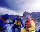
Day 4: Rain Rabbit: (RM 52 to 29; 23 miles). Today, the geology would dramatically change as we slipped and sloshed through a rapid about once a mile. The pygmy forest-studded red walls of Desolation changed into the Gray Canyon lower cliffs of bland pastels (gray, yellow, brown) dotted with more true desert plants. The only sustained flatwater stretch was near the geologic shift. Rain began as we passed McPherson Ranch (owned by the Ute Tribe, as is most of the river-left bank along the Deso/Gray) and continued almost all night. Wire Fence and Three Fords Rapids (RM 37) were the more difficult today (class 3+).
We enjoyed a brief respite during lunch just above Three Fords Rapid. We had watched George and Kerry maneuver for position between three rocks and a hole, and we were preparing to leave when the storm swept in, rolling gray mist upriver and into our lunch zone. Additional clothes came out, and I was happy to be wearing my farmer-Jones wetsuit. We cowered behind a brushy windbreak until the leading edge of the storm had ripped past. Then, we continued into the drizzle.
Three Fords Rapid looked very challenging, but we had great position at the head of the rapid and grazed the hole as we powered the lateral as directed by our captain. Setting-up far-right in the rapid and the initial entry seemed to pass in slow-motion, then we whooshed through on adrenaline. Yow and yikes! The "motley crew" of the other paddle raft are looking more coordinated in their efforts to negotiate the rapids as a team, and the outcome is that no one has gone for an unintentional swim. But, no one is swimming today, it's just too cool. Craig mentioned that because this is a "drop and pool" river section, it is a good place to practice river techniques. For me, it was too cool to practice swimming.
George had managed to get the camp just below Rabbit Valley Rapid, a popular location for commercial trips. The wind and intermittent rains were with us as we enjoyed some of the best salmon I have ever tasted, cooked by Chef Roger. However, the massive gusts of wind added some grit to Ursula's otherwise wonderful cobbler. No partying tonight, because everyone retreated to tents to escape the rain, which continues as the light fades, wind buffets the tent, and I conclude the day's journal notes.
|
|
Day 5: Flushed Out: (RM 29 to 12; 17 miles). It rained nearly all night, but mercifully stopped about dawn. It was a gray, cool (morning temperatures were in the 40's) day, with the extra clothes out of the bag today. Looking back up-canyon, we could see snow on the plateau. The Desolation plateaus are obscured by ponderous dark clouds. Burr.
Sterling and I debated the nature of the penultimate groover call, is there such a thing? Carol noted that the kayak group camped on Ute land across the river spent an inordinate amount of time watching the scenic groover, which had been situated for dramatic effect on the far reach of the sand spit.
The Coal Creek Rapid (RM 26) contained several rock surprises, and was the difficult rapid for the day. The other rapids were mostly big standing waves, and we got wet several times, but no one went for a swim. An access road appeared at the top of Nefertiti Rapid, marking the top of the day run from Nefertiti (RM 20) to Swaseys Rapid (RM12). I tried to get a photo of Nefertiti Rock, but I discovered that the best perspective is while one is in the rapid.... The Price River lazes in from the West bank (RM 18), adding a gray silt stripe that endures for ½ a mile or more in the brown murk of the Green River.
We stopped for lunch in view of Gunnison Butte, the marker for the end of the canyon, where we sliced through the leading edge of the Book Cliffs to look at the open space of the desert country. These are the vertical stratified cliffs that look like a library of stacked books one sees when traveling UT-6 or I-70 near Green River, Utah. We were still under a gray umbrella of clouds, while fluffy floaters dotted the sky over the open country.
Another mile and we beached for the last time below Swaseys Rapid (RM12), flushed out from the rapid-strewn Deso/Gray, and began disassembling the rafts and toting mounds of equipment over the sands of the landing. It grew a bit warmer as we changed into our traveling clothes and headed for Ray's Tavern in Green River, traditional celebration spot for wondrous tours of the Desolation/Gray...
Epilogue: A few days later, the river flow recording said that the river level was 20,000 CFS, significantly up from the 16,800 CFS when we started this journey.
Trip participants included: Kerry Amerman, Maria Fruin, Eileen Gidley, Ursula Jochmann, Rob Jones, Kenton Knorr, Sterling Larson, Craig River King McCarthy (trip organizer), Carol Milliken, Russ Reed, Holly Rordame, Elroy Smith, Holly Smith, Leona Smith, Roger Upwall, Todd Washburn, George Yurich, and Jim Zondlo....
(Jump back to the top of this report)
|
Wild Vagabond Main |
Trip Report Index |
Caveat |
|---|