(Click the photo for a larger view; Photo by Rob)
|
|
|---|
|
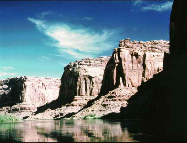
Labyrinth Canyon Bluffs from river level. (Click the photo for a larger view; Photo by Rob) |
(Text
and Photos © copyright by Rob Jones)
Prologue: The Belknap's revised waterproof Canyonlands River Guide map is very helpful. We started at Green River State Park in Green River, Utah and got off the river in Mineral Bottom. This stretch is Class 1-2 water. This, or any Green River trip requires a shuttle. If you miss Mineral Bottom, you will end up at the confluence of the Green and Colorado Rivers. The only way out of the confluence/Spanish Bottom is to arrange a tow to Moab, up the Colorado. If you are incredibly tough, you might hike the 1600' of elevation on the trail to the Doll House area of The Maze, and meet the beat-up four-wheel-drive shuttle you arranged (not recommended). If you continue downstream from the confluence, it will be the final trip of your grand existence...because you will soon be submarining the giant rapids of Cataract Canyon. You can start at the Ruby Ranch and save time and be in the canyon sooner (it is just above where the Labyrinth Canyon walls close in). If you go, first check the USGS streamflow web site.
Day 1: CFS Cruise. (River mile 120 to 105) Jim Marchel and I left Smog Lake at 7 A.M. for the start of our canoe trip down Labyrinth Canyon of the Green River, from Green River State Park to Mineral Bottom (river Mile Post, MP, 120-52). We arrived early enough to eat something from the breakfast menu at Ben's Cafe in Green River (Utah). Then, over to Nolan Curtis' house to make final plans for the shuttle. Nolan would pick up my Subaru at the Green River park boat ramp, keep it until the day we were coming off the river, then drive it to Mineral Bottom to get us. As we were loading the canoe, a dust devil pounced on us and filled the canoe with sand and dirt before it stalled over the river. Great, and I had just cleaned equipment too.
We departed in relatively high flows, 15,000 CFS, and went down river fairly quickly for 15 miles today. Floating under the railroad trestle, under the twin ribbons of I-70, we entered the suburbs of Green River. We found Crystal Geyser and got on shore to investigate. Walking up the travertine steps, we found the cold water sputtering from this abandoned CO2 well. No geyser today. Back on the river, "It's the brown, not the green river," we thought. It becomes more green as it cuts into the Kayenta layer farther downstream. We also guessed that it was rolling along at 5-6 MPH. Passing The Auger, a side flume, we paddled hard to avoid a series of standing waves. There were not many good camping sites because of the high water, but we spotted some cottonwoods, then heard the roar of the diesel water pump. On we went to avoid the din of civilization, camping along the east side of the river under some huge cottonwood trees. Swarms of horseflies attempted to eat us alive, but they mysteriously disappeared after we set up camp. The crescent moon headed west and the gentle yellow light waned and Jim searched the old river channel above camp - looking for treasure rocks. We are firmly on the river at last, I didn't believe this would happen because we had previously canceled this trip three times.
Day 2: MP 105 to 85. It had cooled nicely during the evening, but the A.M. sun rapidly warmed us. The river continued to roll quickly along and we made fairly good time. We passed The Anvil (also called The Inkwell) and then the dry land dredge (MP 99, good camping here). A little farther down (MP 97) we passed Ruby Ranch on the E side, with the inconspicuous mouth of the San Rafael River on the W side. Don't blink. You can start at the ranch and save time and be in the canyon sooner. Here the walls started, low at first. It was quite hot down to Three Canyon, AKA Trin Alcove. We saw five more canoes here, having seen ten canoes of boy scouts and two of the folks who left Green River State Park just before we did. The river slowed some and the character changed a little more. We stopped between MP 86 and 85 and camped on this long bottom under one of several cottonwoods. I hiked the side canyon directly to the east and cornered a deer, then went to the top. There was no river view, however. There was poison ivy near the two seeps I saw in the side canyon. The evening cooled nicely after sunset and some cool air flowed up the canyon.
Day 3: River Registration. MP 85 to 72 (13 miles). The canyon walls grow taller today as Wingate Sandstone appears at MP 84. Wingate, the cliff-building layer. It's a massive milk chocolate layer of sandstone, soaring 400' or more. Now we see Navajo, Kayenta, Wingate Sandstones towering above river level. It's very hot, and early in the day. When the Chinle layer appears, around MP 79, the river seems a little greener, like its namesake. So, Chinle is the secret of The GREEN River. At MP 76 we hiked Hey Joe Canyon and visited some old uranium mines. There is refreshing coolness to be found in the lateral shafts. Who cares about lowering their sperm count? Environmental degradation is already thought to be responsible for a 40-60% lowering in this "precious" count over the past few decades. Radon gas only affects republicans. Praise the lard. One of the shafts and a loading platform are not far above river level but the most interesting stuff is up the canyon about a half mile. It's worth the hike.
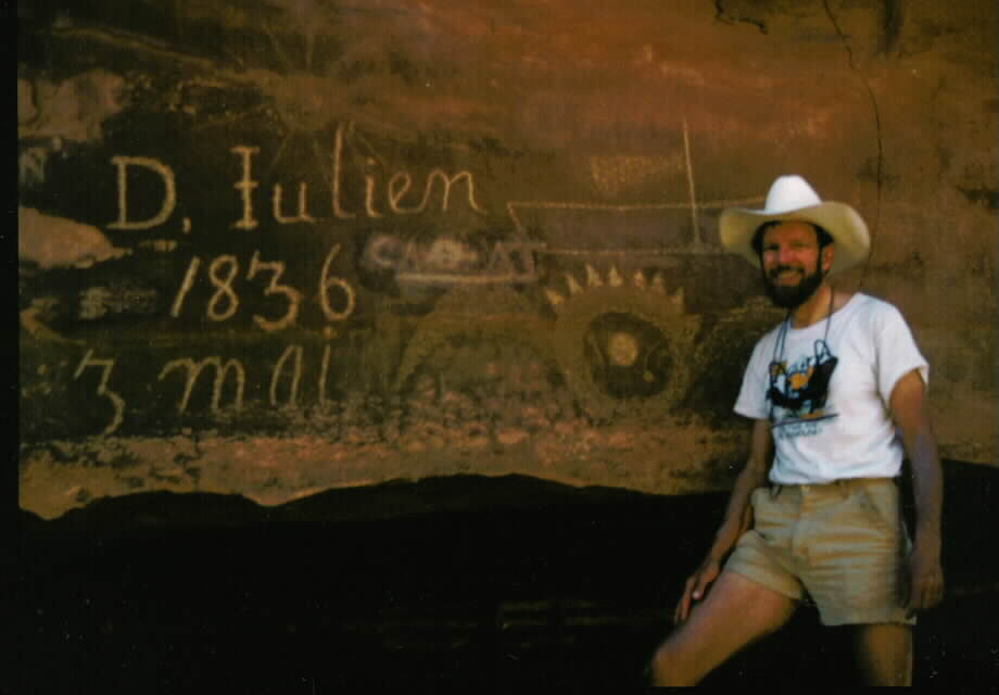
The River Register, near MP 77.5, is in a sweeping right bend. There are many older inscriptions on this sprawling sandstone canvas, alongside new trash. Jim and I added our names to the paper version of the register and watched the carp stick their noses through the scum circulating in a tiny eddy behind a boat-gouger rock in the river bend. Downstream we tried to locate the difficult to find first (upstream) D. Julien 1836 inscription near MP 74 - but didn't. We later learned it is just above the high water mark. In contrast, the painted "Launch Marguerita 1909" inscription near MP 73 was obvious. Just below this inscription, the river was particularly placid and easy to navigate, and we drifted along watching the canyon rim edge lazily rotate above... There's a road on the east side from the Hey Joe mine to Spring Canyon (MP 89) and beyond to near MP 61 according to the map. Thankfully, it is not visible from the river because it is obscured by the impenetrable tamarisk.
We camped in a small canyon on the west side of the river at MP 71.5 at what I believe was our nicest camp of the trip, not far from the river Post Office. The camp is in one of three short canyons close together on the west side. The sunset gratefully came early to this side of the river, and we sat on our tufted bench under a Russian Olive tree and listened to the river gurgle as the hue of the reflected canyon walls subtly changed on its smooth surface. I enjoyed a water bottle bath, after which I found myself covered with a layer of fine sand and silt. But, I am cleaner than I started.
Day 4: Tying the knot. (MP 72 to 57, 15 miles.) From our camp, it was about a mile to the low spot in the plateau separating Bow Knot Bend. We beached near the downstream end of this low spot in the wall and looked for the trail. The trail was not as easy to see as we thought, given the number of people who must hike to the notch. From the notch we could see the river running around the bow knot, although we could not see the whole knot, of course. I signed in Idaho Joe Smegma on a ripple-marked tabula rase from an ancient sea bed and placed it in the pile constituting the river Post Office. Here, vagrants from many points in history have left "mail" for posterity. We also found an inscription painted by the 1914 river survey. After lounging in the diminishing shade, we continued around the bend, traveling several miles by river to return to within a few hundred lateral land yards of where we had stood. It appeared that one could reach the post office from the downstream end too, but that this route would be much more difficult.
Continuing, we stopped in the slack water of Horseshoe Canyon, here an old abandoned river meander. A rincon. It was brushy, hot, and plagued with mosquitoes. Jim and I hiked up the canyon for perhaps a mile, but we grew tired of the limited views and the realization that there were many many difficult miles before we reached anything noteworthy (as far as we knew, that is). If you go far enough, you will encounter the Grand Gallery, perhaps the greatest display of Basket maker-era pictographs. The 200' main scene is composed of giant, alien reminiscent, figures 7' tall. It's an eerie place. (You can also visit the site by hiking down the canyon from a side road to The Maze...see the IAC write-up about The Maze. This version of the trip is about 6 miles.)
Back out into the strong wind, we lost the mosquitoes. Each time we landed to check out a potential camp site, squadrons of mosquitoes and deer flies attacked us. We crashed through the river side riparian brush (tamarisk mostly) near MP 57 and camped at the foot of a talus slope along the west wall. We had seen few good places to camp since this morning. This was an enjoyable place, but the mosquitoes drove us into the tent at 9 p.m. The tent was like a Navajo sweat lodge and we wished we had not set up the tent or unrolled the pads because they served to insulate the ground. Baked from the ground, we were also seared from the air. Thankfully, it cooled rapidly. Hint, wait until sunset, if you can, before setting up the tent.
 |
|---|
|
Rob at the D. Julien inscription Photo by Jim, click on the photo to see a larger view). |
Nolan arrived at 1:30 p.m. We loaded gear and ground up the long exit, overheating the car because of the steep grade, the tail wind (no air through the radiator), and the heat of the day. After an early dinner at the Red Rock (?) or Red Desert Inn, we continued toward the end of our journey. The strong winds buffeted us all the way to Soldier Summit. This had been another good trip with the Marchel. The next day, the river flow recording said that the river level was 10,400 CFS, significantly down from the 15,000 CFS when we started this journey.
|
Wild Vagabond Main |
Trip Report Index  |
Caveat  |
|---|