(a Latin phrase = it is solved by walking)
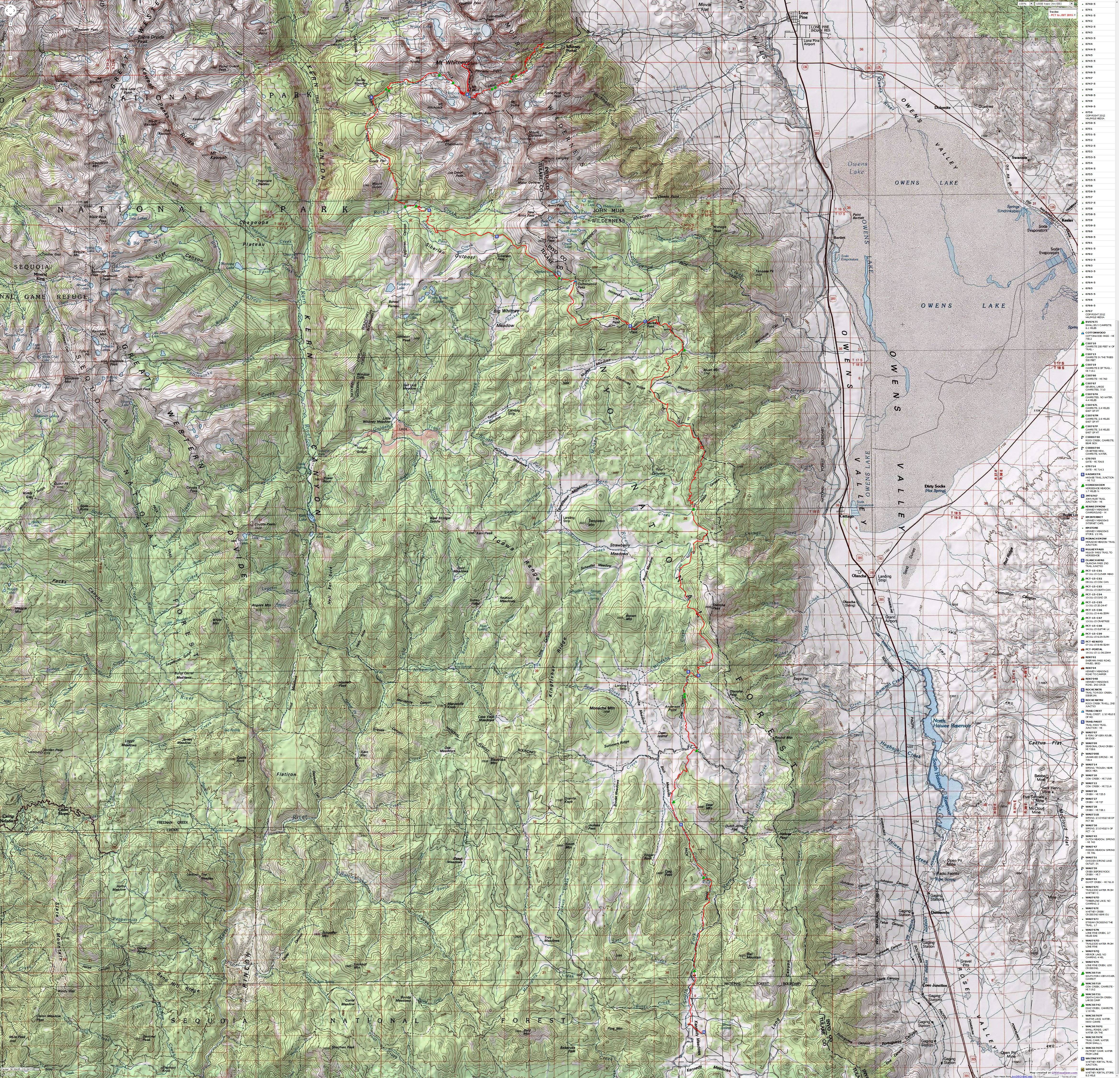
PCT Mile 0702.2 to 0767, then 19 miles to Mt Whitney and out Whitney Portal
(Total miles = 84.9, total ERM = 144)
Text and photos © copyright by Rob Jones

|
| |||||
|
| |||||
|
| |||||
|
| |||||

| ||||
for a full-resolution map, click here (13 mb). Caution - do not use this map or gps track for navigating the route.
| ||||
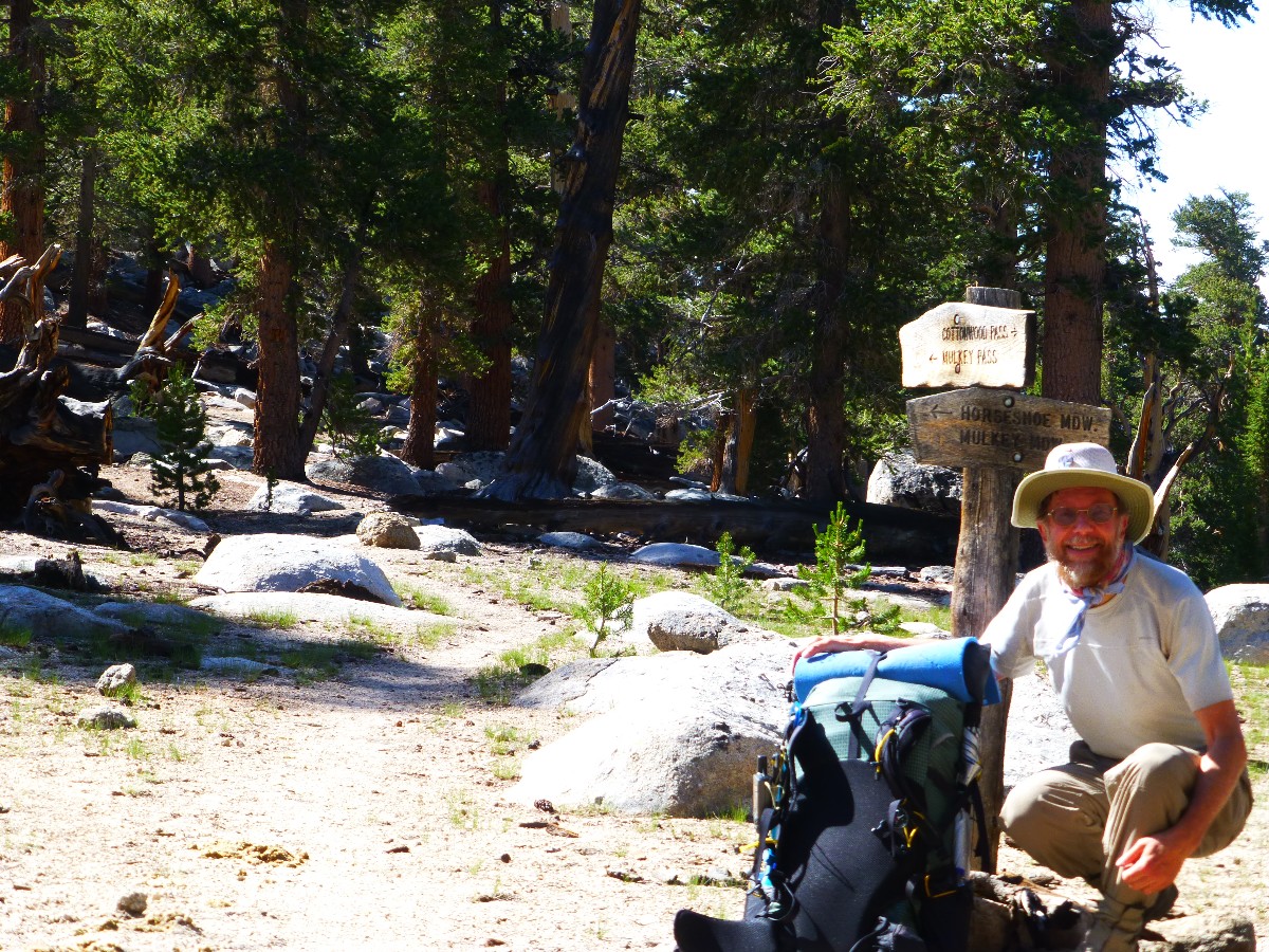
Solo Hike
Camera - Panasonic DMC-ZS19
Summary:
This is a report about hiking a segment of the PCT, Pacific Crest Trail.
This time, from Kennedy Meadows to where the PCT joins the JMT, PCT Mile 0702 to 0767. This PCT to the
JMT segment tied together the PCT sections from Kennedy Meadows to Donner Summit, PCT Mile 0702 to Mile 1159
(approximately 457 miles; total miles hiked on these various section hikes - including going to and from
the PCT is 520 miles).
Standing at the PCT/JMT junction was a connecting experience, yet I still
had to get off the trail (ready or not), so I hiked out via Mt Whitney to Whitney Portal.
I got into hiking the PCT, in segments, following the Jaunty Juggernaut
hike of the John Muir Trail - See the various PCT and JMT reports here --->
All Wilderness Vagabond trip
reports about the PCT, JMT, Sierra hikes I used some of the quotes used in the JMT report - because
they seem quite relevant to this current hike.
I kept notes of distance and elevation gained and lost each day, using my
trusty GPS, and the most excellent Halfmile PCT maps (see links). I used the GPS data to estimate the ERM,
Energy Required Miles. The tracks that form the basis for the map are from the durable Garmin Map 60cs, now
over ten years old. Full credit is due Halfmile and his www.pctmap.net site for maps and tracks used to
design this trip.
I color copied the Halfmile maps (link) on the water-worthy Rite-in-the-rain
paper (paper 8511), double-sided. And, I've used the Rite-in-the-Rain All-weather (lined) Journal #391 for
field notes for many years. It's old-school, yet solid, durable, and versatile beyond any of the smartest dumb
phone (here's hoping technology in the form of cell coverage never comes to special places like the PCT).
Here are my journal notes, some photos, and the daily data and trip map
(tracks from my GPS), and links to the outstanding Halfmile maps, tracks, and waypoints.
 |
 |
 |
Preliminary - driver:
The turkey vultures float gossamer on the stiff and hot desert wind while
eyeing a sun-baked Coyote prowling garbage in a turnout. Earlier, a Roadrunner darts across the road near
Lake Mead, beep beep.
It's 117F at the Death Valley visitors center, where one can hear the heat sing.
I check-in at the Whitney Portal Hostel, then watch the thunderstorm engulf
Mt Whitney, Muir, the whole ridge.
In the group bunk room, testosterone and Adderall plus energy juice-fueled
guys forget their manners and disrupt hiker sleep into the night. It's akin to Grand Canyon trail runners - manners
and etiquette are for others, not all-important trail runners.
Here are my journal notes, some photos, and the daily data and trip maps (tracks
from my GPS), and links to the outstanding Halfmile maps, tracks, and waypoints -- PCT to the JMT.
ERM = Energy Required Miles. A mile is added for
every 500' elevation gain or
loss. It's a very serviceable method of estimating energy required miles. ERM was initially used in Trails
of the Tetons (long out of print) by Paul Petzold, founder of NOLS. It's a wonderfully useful concept and
application. Add one mile for each 500' up AND down to distance = ERM. I use ERMs to calculate what the actual
day is like. It's a very serviceable method of estimating energy required miles. Remember, however, that the
ERMs are estimates because they depend on GPS satellite coverage and math functions.
Using ERMs does not account for the 'texture' of the route or trail - that
is, rocky, boulders, no trail, slimy mud, etc., yet does help approximate the route.
There is additional information about the valididy of using ERMS at the end of this report.
Notes - GPS miles. PCT mileage is given each day. The ERM estimates come from elevation gain and loss figures from my GPS.
“PCT miles” reference the mileage from the Southern US border of the PCT, as specified in Halfmile's maps, a trail bible. See the links section at the bottom of this report for references.
Below is my plan for the PCT to JMT. I produced this draft, using Halfmile and other sources, and I mostly stuck to it.
| ||||
| ||||
 |
 |
 |
 |
 |
 |
 |
 |
 |
 |
 |
 |
Day 1: Clover Creep, or South Kern Start. To Clover Meadows:
PCT Mile 0702.2 to 0709.5 + walk from the Kennedy Meadows Store to the PCT. 8.3 miles, ERM = 12.3. camp at 7040'.
Giganto toad blinks lethargically from his sand bunker. Staying cool,
I suspect. He's trenched himself down into cool sand aside Clover Meadow.
Early this morning, Peter and I meet Alex at Whitney Portal, then shuttle
to Kennedy Meadows. Peter is from Oklahoma via Germany.
After discussions and breakfast with some PCT equestrians, I walk from the
store to the PCT, then start North through open sandy country to the Kennedy Meadow Campground, where I see
the last of motor recreation, I hope, for the next 9 days.
Kennedy Meadows Store, bustling site of Cheryl Strayed getting off the PCT
in the book and movie, Wild, to avoid snow in the Sierra, is still not open as I hike the open Jeffrey Pine
dotted swale of the South Fork Kern.
A Cooper Hawk zooms through the CG while I enjoy the first foot break of the day.
Lunch is enjoyed at the South Kern River footbridge to the sound of tumbling water.
It's quite warm along the S Fk Kern as I walk among Jeffrey Pine, pinyon,
juniper, oak. The S Fk Kern is poorly watered, perhaps providing a glimpse of how come cities such as Los
Angeles, Phoenix, Las Vegas should not exist.
Quiet, I see no one until I am in camp. Water is fading. I search the
edges of Clover Meadow, mostly finding moist areas, yet no surface water. Eventually, I find a streamlet
of cool water along the upper meadow edge.
It's been a relatively short day, yet plenty long wrestling the 43-pounder
packed with food and support equipment.
 |
 |
 |
 |
 |
 |
Day 2. Bounder Bear. To Cow Creek:
PCT Mile 0709.5 to 0719.2. 9.7 miles, ERM = 15.7. camp @ 8340'.
The black bufus bear bounds through Clover Meadows, loping amid the willows.
Gorgeous. It's obvious the meadow is covered in 3 to 4' high willows, rather than the grass it appears to
harbor from a distance. Bufus undulates across the meadow, appearing, disappearing in the willows, like a
porpoise leaping the ocean surface.
The PCT climbs up to the Haiwee Trail junction, through more burn area at
the crest.
Down into Beck Meadows, where I stop under what appears to be the last tree
until another crossing of the South Fork Kern to dry the tent during a foot break. The trail continues
above the meadow, and reveals a sweetwater trough and spring. Hurrah for Halfmile's most excellent maps,
and his gps track and waypoints that help a hiker find (especially) water sources off the trail.
Over the ridge and down, down to the second South Fork Kern footbridge.
Swallows swarm under the bridge, daubing mud on hanging mud houses.
Cows, and a distant house clutter Beck Meadow.
Around the contour I hike, then climb into Cow Canyon, where the water
is nearly gone. Only a tiny puddle remains near camp. Yikes.
Cool wind - from the downdraft of broccoli-head clouds above, clouds bunch
and darken, and hail and rain bounce. I race back from the puddle and nap in the tent.
Later, Trail Snail (Lisa), Lynn, and Emily arrive and share the small camp.
| ||||
 |
 |
 |
 |
 |
 |
 |
 |
 |
Day 3. Death or Death Canyon Decibel. To Death Canyon:
PCT Mile 0719.2 to 0730.8. 11.6 miles, ERM = 18. Camp @ 8966'.
The F-something fighter airplane shrieks out of the cloud bank raining on me,
slightly below trail level and 200 yards (or so it seems) away, dragging a sound wave so loud my startle response
throws the umbrella into the air so I can cover my ears. Yikes! Shades of the Grand Canyon air tour terrorists.
It's disappointing and a sign of our callous mistreatment of the Eaarth (Bill McKibben spelling and meaning) that
so much air and noise pollution comes from frivolous aircraft use. Air tour terrorists in the Grand Canyon,
destroying natural quiet and sealing the porcine passengers from experiencing the Grand of The Canyon. Sure,
there is the handicap-accessible Trail of Time along the South Rim - yet this is not wasteful enough for the
elite, and, gasp, one might hear nature, not rotors - the sound of money - along the trail. Parenthetically,
Zig sends me a brochure from his Northern Tier bicycle tour describing air tour terrorists in "Glacier
Fantasy," sullying the Bob Marshall and other Wilderness - tin can tourists all. Sad. One might note that
air tour terrorists target the wild areas, ruining natural quiet. How come they don't confine their corporate
welfare activities to the flight space over Las Vegas, etc.?
Recovering my umbrella, I note that the drizzle has turned into graupel or
hail. Caused by the booming sound wave?
The day starts from Cow Canyon and heads uphill, to over 10,000' and a lovely
contour through lightning-twisted pines and granite hoodoos. Fog flows through the gap as I start to drop
off the high perch. Doe and fawn hide in the willows, corvids chortle from the snags, and what I imagine are
Sooty Grouse (once Blue Grouse) boom and thump from their brushy hiding place. All day the clouds seem to
pursue me - catching me again as I hastily setup camp at Death Canyon, coating the ground white with hail for
over an hour. I'm doing well so far, napping in the big raincoat (TarpTent) during the afternoon storms.
Aaron from SF arrives near dusk and relates that Trail Snail and crew have
returned to Kennedy Meadows. Aaron is the only person I see today.
All the water, coupled with a cold night produces condensation and a bit of
morning ice.
 |
 |
 |
Day 4. Diaz or Dry. To Diaz Creek:
PCT Mile 0730.8 to 0741.7. 10.9 miles, ERM = 17. camp @ 9650'
Aaron and I are both hopping in place to stay warm. There's a bit of
ice on the end of the TarpTent that is not squirreled under the pine, and a good measure of condensation
too. Cold night, clear sky, lots of precipitation yesterday = condensation.
Coyotes howling nearly in camp wake me twice during the night. Lovely.
I wake up to the yip of the Song Dog, and I'm also glad that I brought my better insulated neo-air.
It's sunny, so I hike to finish warming, and it works. Up through
fragrant Mountain Mahogany - perhaps more odiferous from the hail beating? A few rows of hail remain
in the forest. Up into the granite hoodoos and vistas to unknown mountains of the Great Western Divide
to the West and meadows. A carpet of granulated white granite or quartz monazite provides a pleasing
yet stark contrast to the Red Cedar and twisted Foxtail Pine - the colors made more saturated by the rich
low-angle morning light.
Wiggling along the Inyo-Tulare County line, the PCT is a crestival. It
bobs along, gathering more ERMs. I pause for a snack and to dry out the tent, a daily ritual.
I find water in Diaz Creek and a sheltering 4' diameter pine just in
time to tent the 3 p.m. storm. Diaz or dry indeed. Now it's time to filter water and consider a cold
rinse. I have not seen anyone since Aaron in the a.m. Rain splatters most of the late afternoon.
 |
 |
 |
 |
 |
 |
Day 5. Three Passes to Chicken Station. To Chicken Spring Lake:
PCT Mile 0741.7 to 0750.8. 9.1 miles, ERM = 14.6. camp @ 11,260'.
I see two hikers ahead. With day packs? What? Then four more, eight. Yikes.
It appears I've arrived at Cottonwood Pass with a hoard hiking from Horseshoe Meadow. I join Tony and James who
are hiking to Yosemite Valley and marvel that Chicken Spring Lake is even more overpopulated.
Mulky, Trail, and Cottonwood Passes today, along with views into Mulky Meadow
and interloper cows in Poison Meadow.
There's sweet water from Poison Meadow Spring - up slope of the bovines. Mount Langley appears like Whitney on
the near horizon, cluttering the view toward the big peak.
I enjoy a solitary hike, at least to Cottonwood Pass, and a languishing snack
with the traditional drying of the tent.
At Chicken Spring Lake, I consider moving on - but desire a bath and some laundry,
and the next water is 9 miles ahead at Rock Creek.
Mules arrive across the tiny lake bowl and one begins to bray in a frenzy - as
if they see a tea-bagger who wants to sell their wilderness. Hint, they do.
A fat Marmot appears. It's very cool but doesn't rain. The sun appears long
enough for a brief and brisk bath. Gnarled Foxtail Pines bear witness to multiple lightning strikes. Yikes. An
evening for the first hot water bottle.
 |
 |
 |
 |
 |
 |
 |
 |
 |
Day 6. Rock-a-bye to Rock Creek. To Rock Creek crossing:
PCT Mile 0750.8 to 0760.5, 9.7 miles, ERM = 15.7. Camp @ 9580'.
The music of sweet Sierra water - the first! lilts through the
Lodge Pole and Foxtail Pines at Rock Creek crossing - last water North for 7 miles (Whitney Creek)
and South to Chicken Spring Lake. A very dry year indeed. It's been a day of luxurious touring through
alpine terrain with occasional vistas of sawtooth mountains (far West, to the Great Western Divide) and
expansive meadows far below. Most of the ERMs today come from the down elevation, while tomorrow it's back up.
I'm nearly down to my intended camp by noon, so I visit the Rock Creek RS.
No Ranger about, yet a good place to lounge.
Proceeding down to the Rock Creek crossing, I find, with some trepidation, that the light hiking group is
with an outfitter, the one with the very vocal mule. Oh no. I wait to see where they will camp, while
encountering several parties going to or from Mt Whitney via Horseshoe Meadow. The mules arrive and clop
down canyon, I note with glee.
At dusk, I'm the only person in this gorgeous camp. Yahoo. Best camp
of the trip, so far.
 |
 |
 |
 |
 |
 |
 |
 |
 |
Day 7. PCT to the JMT! To the PCT/JMT junction, to
Crabtree Meadow, an eponymous day:
PCT Mile 0760.5 to PCT/JMT (0767) + 1 = 7.5 miles, ERM = 13.5. Camp @ 10,660'.
Late morning and I've arrived at the PCT/JMT junction, PCT Mile 0767 from the
Mexico border, tying together the PCT sections from Kennedy Meadows to Donner Summit (mile 1159.3). I've hiked
about 460 miles of the PCT. See the various PCT and JMT reports here --->
All Wilderness Vagabond trip
reports about the PCT, JMT, Sierra hikes
Yahoo. I recall pausing at this junction during the Jaunty Juggernaut of
the JMT and feeling the pull, the animal
magnetism, of the PCT - come hither, hike. Hike on.
Michaela comes along and takes a commemorative photo of the joining of the
PCT/JMT/PCT segments, and I take her photo too.
Earlier, I meet Honey Bun (Griffin) and Brian of NZ, who are hiking the PCT.
Today is day 47 of their trek. We talk trail before they bound off to hike Whitney and continue the PCT, all today.
Easing into Crabtree Meadow, I go to the RS and talk extensively with Rob Pileweki, Crabtree Ranger, then
decide that this is a grand place to camp tonight rather than moving to the Guitar Lake area. We talk about
the invasive beefaloo on the North Rim of the Grand Canyon, climate change, repulsican sequestering of public
land funding - that has resulted in deteriorating conditions in all our precious parks, etc. Looking for a camp
spot, I again see James and later Tony - who was day hiking Mt Whitney.
The water is pure, the meadow grand, camping among the trees Foxtail, and the
camaraderie deluxe. It's a busy area, yet pleasantly so. Tony, James, and I enjoy story swapping over dinner.
It's a fine, mellow, warmish evening at 10,000 plus feet. Quiet at dusk, replete with calm winds and a
soothing backdrop of tumbling, cascading Sierra water.
 |
 |
 |
 |
 |
 |
| ||||
Day 8. Guitar City. To Guitar Lake
Crabtree + 3 miles, ERM = 5.5. Camp @ 11,550'.
The windswept glaciated boulderfield of the Guitar Lake cirque is
dotted with splotches of colorful tents and bivies. A bottleneck of this, the West side, of Whitney.
It's Guitar City. The solar load is intense, and the wind has a bite. Thankfully, the breeze is rarely
a wind because sheltered tent spots are few. The ridge leading up to Whitney is stark and sheer,
presenting an imposing monolithic wall to the East. Hikers are contemplating a 2 a.m. start to greet
the sunrise on Whitney - yet not me because I don't want to hike in the cold darkness.
Temps dip dramatically when the sun goes behind the wall and many scramble
for their tents. Still, it's relatively warm for this cold air slump.
This morning was a lazy one. The tawny meadow warms quickly in the full
sun. Parenthetical, Ranger Rob predicts clear weather for the next few days - giving Whitney want-to-bes
a window of opportunity. It's most excellent news after days of being chased by thunderstorms.
The brief, yet demanding trek up to Guitar City is such because of the
increasingly rare air. Sure, it's 21% oxygen, and these precious particles are increasingly farther apart,
and one must haul more air to get the same dose as in lower climes. Puff, puff, wheeze. Best wishes, and
for a warm sleep from Guitar City at 11,550'.
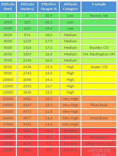
Although air contains 20.9% oxygen at all altitudes, lower air pressure
results in an effective oxygen % of about 12% on Mt Whitney, 16% at 7,000' on the Colorado Plateau. See
graph here.
| ||||
 |
 |
 |
 |
 |
 |
 |
 |
 |
 |
 |
 |
 |
 |
 |
| ||||
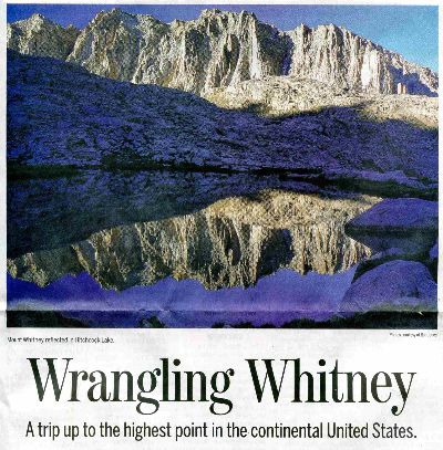
Day 9. Wrangling Whitney. To Mt Whitney, then Outpost Camp:
11.4 miles, ERM = 24. Camp @ 10,416'.
I can see headlamps inching the Muir Ridge towards Whitney when I get up at
4:30a.m and look out of the tent. Ambitious hikers hoping to see the sun rise from Mt Whitney.
I'm on the trail by 6:30 and inching myself into increasingly rare air. It's a delightful morning, and only
the basic cold weather gear is required - and it gets stowed in the pack after several switchbacks. Setting
a pace that allows breathing, I reach the Mt Whitney junction and take apart the pack - placing the Bear
can separate from the pack. Guitar City and Crabtree rang with tales of Marmots pilfering packs.
Then, it's up the 2.1 miles to Mt Whitney, where it's sunny with calm winds,
a rarity. Far less snow when I last visited, in 2010, and it's over a month earlier. Water (the lack of
water, and lack of potable water) will eventually limit population - via religious war, war for greed,
corporate welfare wars, common and preventable illness (dysentery, cholera, etc.), and other methods - yet
not through education or enlightened government action. (Look at the middle east, including Wisconsin, to
see the impact of religion rather than government, population growth, poor or no education, water shortage,
economic imbalance, etc.) Sure, we have terrific scientists, yet tea-baggers disdain science because they are
only interested in transferring wealth and water to corporations while shouting about limited government.
Government intervention has a distinctly superior track record when dealing with environmental, social, and
banking crises, yet tea-publicans are allowed to falsely revise history, over and over. For instance, trickle
down economics is a raging falsehood, without any empirical support. Religionists are doing exactly the wrong
thing, promoting a self-fulfilling prophecy of more babies and no science to doom. Help with economic and
environmental justice? Naw, the religionists will clamor about gays, abortion, while creating more retrogressive
and unsustainable
(returning to an earlier and worse situation) government through their narrow issue voting. Ignoring some
700 bible directives to help the poor, religionists vote for conservatives who literally take the food from
children's mouths and give the benefits to corporations. "Take our country back," they chant - to the dark ages.
“I do not believe that just because you’re opposed to abortion, that
that makes you pro-life. In fact, I think in many cases, your morality is deeply lacking if all you want
is a child born but not a child fed, not a child educated, not a child housed. And why would I think that
you don’t? Because you don’t want any tax money to go there. That’s not pro-life. That’s pro-birth. We
need a much broader conversation on what the morality of pro-life is.” - Sister Joan Chittister, of
the Order of Saint Benedic, speaking about the gop relentless attacks on women and children everywhere.
Summit photos and videos and a snack and time to start down as the wind picks up.
Halfmile says Mt Whitney is 14,505' per the 1988 NAVD88 vertical datum - and
it feels every bit this high. It's the highest point in the continental United States.
Repack the pack - thump a Marmot, and head for Trail Crest amid the Sky Pilots.
Hundreds of switchbacks make one dizzy on the way to Trail Camp, where another mass of hikers is preparing to
assault Whitney. It's the local environment that they're assaulting, with many not using their wag bags.
Ick. Questionable water quality, I don't get water until Outpost Camp - which has a flow tumbling in from the SW.
It's a long drop to Outpost Camp, which follows the up and up to Whitney
from the Guitar City side.
My in-line sawyer filter is working well this trip. I use it in-line during
the day (dirty water in Platypus hydration bag, filter, outlet to drinking tube) and as a gravity filter in
camp. One secret is to ignore the sawyer storage directions - always, always keep the filter elements wet.
I store my filter in a bottle of mild vinegar or bleach solution at home, and store it inside the tent, water
in the filter (not shaken out) during the night. A backflush with hot vinegar revives the filter at the end
of the trip.
I throw camp together and endure a quick bath as my energy and the light fade.
The first 8 ounce gas canister fails, after 18 or 19, 1 liter boils. This is about what MSR estimated. Sure,
I'd like to be using my trusty alcohol stove, yet fire restrictions prompt me to use the gas stove.
The sound of tumbling Sierra water again sooths the night, this time at
Outpost Camp. I dream about eating a snack of a chili verde burrito, smothered with chili verde and
wrapped in a pizza while hiking the fog of a grand traverse above the Great Western Divide.
| ||||
 |
 |
 |
 |
 |
 |
 |
 |
 |
 |
 |
 |
Day 10. Portal Promenade. To Whitney Portal:
3.7 miles, ERM = 7.7. Total miles = 84.9, total ERM = 144. 0.
The clear water flows, Monkey Flowers glow from a fish-friendly
gravel bar lined with Shooting Stars and Paintbrush. Sun glints from polished white granite teeth.
It's a lovely, warm morning along the Mt Whitney Trail. I have the simultaneous and conflicting desires
to stay and to go. Go to see Kathleen, Gordon, other adventures. Stay to experience more of the PCT and etc.
Yet, the wag bag is full, so I must go.
PCT to the JMT, a deluxe adventure! Solvitur ambulando!
| ||||
Epilog - Maroni and Cheese, please:
I help Christian (with pancake in photos) and Bryce eat part of
their massive Whitney Portal store pancake, while inhaling a Whitney Burger of my own. Then, after
transporting these JMT hikers to the Whitney Hostel, I add Shawn to my load and we travel to Bakersfield,
where he catches Amtrak South to a new teaching job.
I continued to the Fresno area, wrapped in smog and heat. Gordon and I
enjoy some late discussion. Kathleen flies in, and Gordon, Aniesa, Kathleen, and I enjoy a Basque dinner
at the Shephard's Inn before Maroni and Cheese (The book of mormon Production at Saroyan Theater). Excellent.
Thanks Gordon.
Kathleen and I enjoy one of those long lunches with George and Nancy.
George was a member of the first group to climb El Capitan (see Argosy article in links). Talk ranges from
Canadian Grizzly to Sierra Pika and beyond.
Then, avoiding the insurance company death panels (you're out of coverage,
that is, out of network; it's time for universal health care), I endure some medical tests in Fresno. Not a
fun end to a glorious adventure.
As we leave the central valley for cleaner and less-populated air, I watch
thunderheads blooming vaguely through the smog, tens of thousand of feet above the PCT and the Sierra Crest
and wonder about life up there on The Trail.
 |
 |
 |
 |
 |
 |
 |
 |
 |
 |
 |
 |
 |
 |
 |
.
*ERM: Energy Required Miles, are there data to support this
mileage adjustment?
Journal of Outdoor Recreation, Education and Leadership
Petzoldt first proposed his theory in his 1976 book “Teton Trails” to
help backpackers plan trips and calculate their energy needs on mountain trails. “Petzoldt defined one
energy mile as the energy required to walk one mile on the flat. He recommended adding two energy miles
for every 1,000 feet of elevation gain, so a person hiking one mile and 1,000 feet upward would use the
equivalent of three energy miles,” Phipps said.
Petzoldt’s energy mile theory was just a reflection of the mountaineer’s
“gut feeling,” Phipps said. The theory had never been tested in a laboratory before the study began in WCU’s
Exercise Physiology Laboratory in the spring of 2010, Phipps said.
To determine the validity of the theory, the study measured the energy cost
and perceived exertion for walking on flat ground, with and without a 44.5-pound backpack, and up an elevation
gain of 1,000 feet, with and without the backpack, through the collection of metabolic data, Phipps said.
Twenty-four student, faculty and staff volunteers, including 12 males and 12
females, went through four testing sessions as the research continued into fall semester of 2010. The study
results showed that the additional energy cost for ascending 1,000 feet ranged from 1.34 to 2.02 energy mile
equivalents, for an average of about 1.6 miles, compared to Petzoldt’s use of two energy miles for each 1,000
feet. The range revealed by the study was due to the “hikers” personal weight differences, Phipps said.
“It is remarkable that Petzoldt’s energy mile theory is so close to the actual energy cost measured during our
study,” Phipps said. “In the field of outdoor education, it’s important for leaders to include an estimation
of energy requirements during the planning of hiking trips.”
Phipps said the energy required for hiking up steep mountain trails would vary
for individuals and groups, and the variables of the trail would also factor in, but he recommends that
backpackers stick with Petzoldt’s idea of adding two energy miles for every 1,000 feet of elevation gain when
planning trips.
The Validity of Petzoldt's Energy Mile Theory, 2010
Authors: Maridy McNeff Troy, Maurice L. Phipps
Publication: Journal of Outdoor Recreation, Education, and Leadership
.
| ||||
.
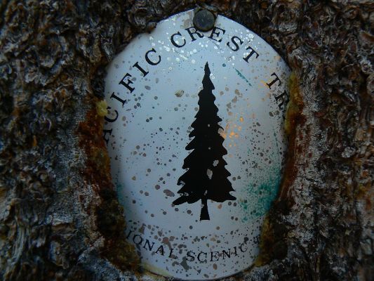
Click here or on the PCT trail marker to go to all WV reports about The PCT, JMT, Sierra hikes
| ||||
Half-mile site: Pacific Crest Trail Maps and GPS Information - a terrific resource
Pacific Crest Trail Association
Click here to: see the First ascent of El Capitan, Argosy Magazine, 1959 (10 pages) 22 MB.
Marc Reisner (1993) Cadillac Desert: The American West and Its Disappearing Water, Revised Edition, Penguin Books
Bill McKibben – suggested books include: Maybe One, Eaarth, The End of Nature
Pacific Crest Trail – Plan your hike site
Bear Boxes in the Sierra Nevada
Post Holer site - maps and resources for planning (PCT site)
About the PCT - has info about equipment (semi-commercial site)
The waypoints with numbers, e.g., 0767, indicate PCT mileage from the Southern US border.
| ||||
for a full-resolution map, click here (13 mb). Caution - do not use this map or gps track for navigating the route.
Click here to: see a movie about Yosemite Glaciers (what's left of them).
movie about Yosemite Big Trees (again, what's left of them).
movie about Yosemite Wildflowers.
Scenic Toilets of Inner Earth: Scenic Scatology of the Wilderness Vagabond
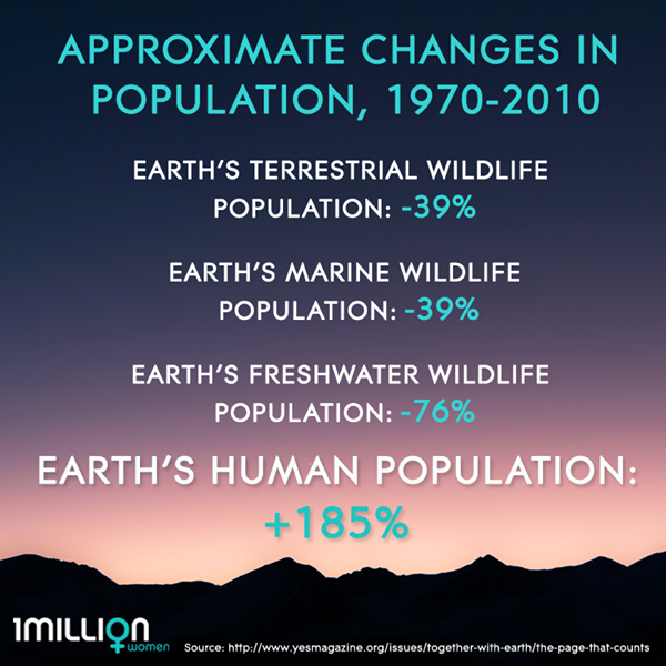
We Are Breeding Ourselves to Extinction (click here for full article) or at:
Breeding ourselves to extinction?
More Truth Than Joke:
| ||||
| ||||
| ||||
| ||||
| ||||
| ||||
| ||||
|
Wild Vagabond Main |
Trip Report Index  |
Caveat  |
|---|


