
Click the picture for a full 1000 X 700 image (58kB).
|
|
|
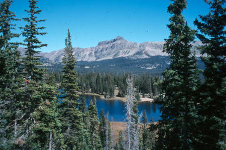
Kings Peak (center) from the Henry Basin - photo by Rob Click the picture for a full 1000 X 700 image (58kB). |
|---|
|
|---|
|
View of Hayden Peak
(Click the image for a full-size view (37k); Photo by Bob Fagley) |
Wasatch-Cache National Forest
8230 Federal Building
125 South Stale Street
Salt Lake City, Utah 84138
(801) 524-5030
The night before the big trip, I had almost completed the sprinkler system, following 12, 14-hour days of digging and grubbing. I quit replacing sod at 7 p. and raced to the store to make up for not preparing for the hike. When I returned, there were 2 llamas in my back yard. A long white nose quietly snorted at eye-level as I went into the back yard. Elegant camelids, they sounded like there were harmonicas in their long graceful noses. It was Gaylon and a group of 7 Idahoans, 2 llamas, and 4 dogs, also Idahoans, who had arrived this late afternoon prior to starting the Uinta trip. And, I am a native Idahoan. Because of the mudfest in my yard, some stayed group members over at my neighbors, the Days'. This is my first official IAC trip, although I have submitted trip reports from previous trips.
|
Wild Vagabond Main |
Trip Report Index  |
Caveat  |
|---|
Day 1: Long shuttle: (hike 2 miles, 1/2 hr.) Following breakfast at Marie Callender's, we left the city of smog at 10 a. And most of us drove to Center Park TH on the SE side of the Uintas. The llamas and the remaining crew continued to Spirit Lake TH. After leaving one car at Center Park, we joined the others at Spirit Lake, and Gaylon's sister and b-in-law began the shuttle with the llama trailer and vehicle back to Center Park. Whew, it was a long day already (7 p). We hiked to Tamarack Lake (2 miles) and camped. It's refreshing to be in the mountains.

| ||||
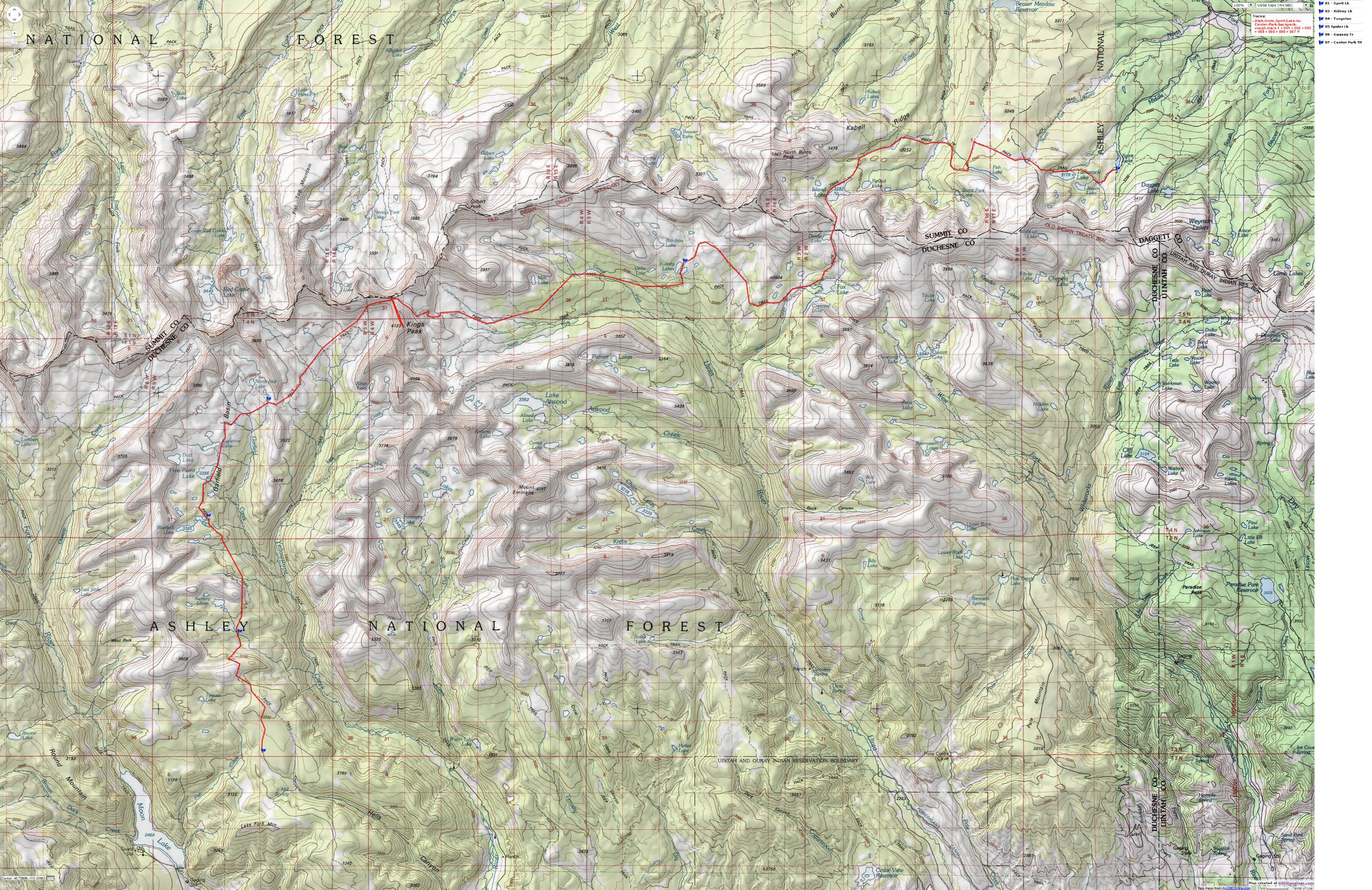
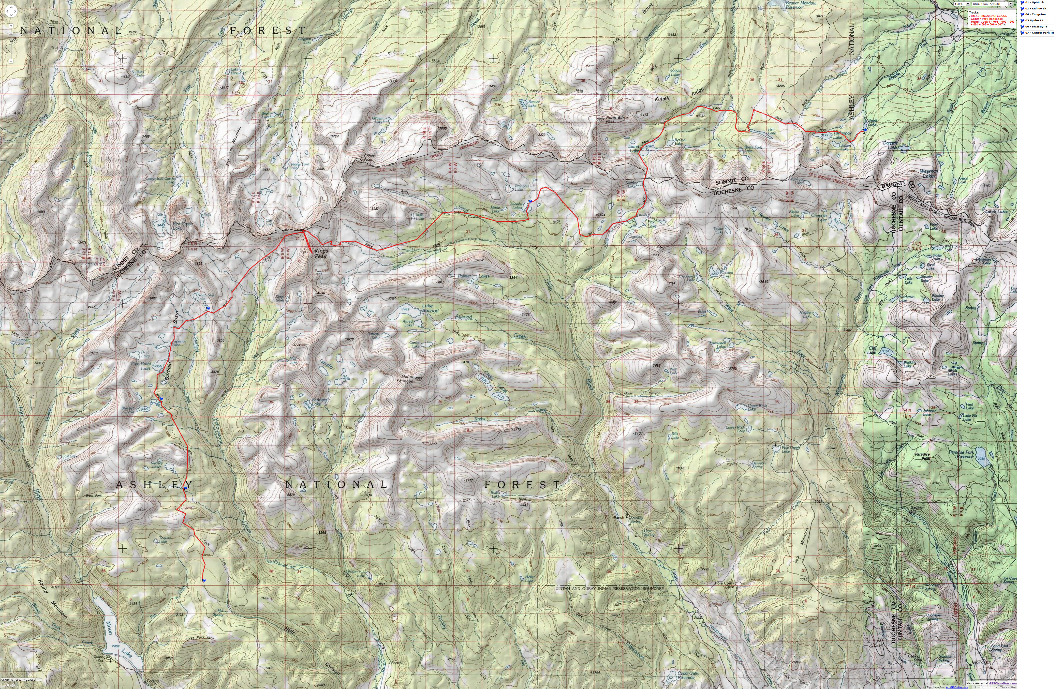
If you want to view a full-resolution map, click here. Caution - do not use this map or gps track for navigating the route.
Day 2: Tamarack to Island Lake, 9 mi, 5 hrs. I am writing from a vantage point of Island Lake and the big ridge forming the E-W escarpment of the Uintas. We are at 10,700' after starting from Spirit Lk at 10,200'. We saw our second mooselet today. A fine, high altitude hike it was, through stands of Douglas fir and open parks with names like Bear, McCoy, Burnt Creek.
Day 3: Island Lake to Kidney Lakes, 9 mi, 7 hrs. Sunrise came across Island Lake and into the tent. The trail toured around the lake and into the mid-morning, then up the pass between Island and Fox Lakes, from 10,777 to 11,200'. Then, I went up the ridge nose to Mount Squatless (local name) at 12,010' which afforded excellent views of Island and other lakes. Following, gorp #1 and basking at the pass, we walked down the reclining tundra to Fox Lake, where we joined the Highline Trail. The Highline Trail traverses on-and-off the high divide, across the length of the Uintas. The trail was rocky as we hiked past a huge bull moose. He eyed us, but mostly ignored us as he pruned the willows, tossing them into the air. It was a longer than expected day, and few had energy for much but camp activities. The Kidney Lakes were beautiful and they catch the sunset and sunrise, mirroring the glow on the mountains.
Day 4: Milk Dud Mammary (12,916'), 7 mi, 5 hr. Trail; 4 mi, 3 hr peak. Kidney to Painter Basin. Today, there was more trail than rock, a welcome relief from yesterday. The clouds threatened much of the day, but we received only a little cloud spit. I saw the essence of moose #4 (bull) as his antlers skimmed just above, then below the willows, creating waves in the high willow branches. We set up camp near where the trail circles the West moraine leading to the Anderson Pass/Gunsight junction, at about 11,100'. After gorp #3 and some irrigation, I packed a day pack and headed up Milk Dud Mammary Peak (12,916'), so named because Milk Lake is on its SE flank. A bit of a milk dud tippet forms the top of this mammary-profile peak. There are tippy refrigerator-size sandstone slabs on the top portion. The peak continues up, West, to a second summit at over 13,000', just E and above Gunsight Pass, but this entails an additional mile or more of rock-walking in the rare air. I had hiked more than enough by the time I returned to camp. The camel-noses are mewing in the meadow and the clouds appear to be going to bed.
Day 5: Static Dancing; Painter Basin to Tungsten Lake, 10 mi, 8 hr. Kings Peak #3 (13,528'). We are up early and on the trail to the high pass of Anderson. Then we rock-hopped up Kings Peak (highest point in Utah, at 13,528'), where there is now a trail-type route. A squall moved in as we approached the summit. After reaching the top, most of the group immediately headed down. A strange hum and hissing began. Wind through the hood of my raincoat? No, static electricity. Eiiiah! Then the hail, which made the lichen-covered rocks very slippery. Caution overcame urgency as we booted down the jumbled sugar cubes of sandstone. Back at the pass, there appeared to be a convention forming. More hikers than we had seen to this point. Gorp, then down and over toward Tungsten Lake, through the upper regions of the Yellowstone drainage. Spatters of rain joined us on this stretch. Over low Tungsten Pass we hiked and to camp at Tungsten Lake. Hail and rain showers forced us into the tent to eat dinner. Later, after the storm sequence, the stars were brilliant and nearly lit the trail.
Day 6: Mellow Yellow; Yellow Peak (11,884'), Tungsten to Spider Lakes, 5 miles, 5 hrs. After a lazy morning, Paul Worth and I hiked up Yellow Peak, a low peak situated in the high middles of the basin. I found a broken arrow head and saw a spruce grouse and chick. Then, we were rolling through the basin past the salt house of the salt house of the 1920's - for curing meat - and on to Spider Lake. Jerry Dixon came by from Porcupine Pass, hiking solo with the intention of traversing from Hayden to Flaming Gorge. I did not know it was Jerry until he introduced himself. I met Jerry in Pocatello, many years ago. He was visiting from Alaska, having just finished rafting the Colorado.
It was a day of reflecting about how much more pleasant it is to hike with llamas versus dogs. More alert, yet less whining and other noise, excluding that harmonica hum. Less digging/destruction of the area, at least as far as I have seen. They don't bite. They carry more too.
Day 7: Somnabulistic Sentinel: Silent Sentinel Peak (12,206'), Spider Lake to Swasey Hole, 5 + 4 miles, 5 hrs. We awoke to frost and a skim of ice on the water bottles. Paul and I hiked the rocky route to Silent Sentinel Peak (12,206'), with 8 6' sentinel cairns gracing it's rounded top. The high point of the ridge is West of Spider Lake. It's a mound of boulders and even the ridge is a rock path. After we came down, I joined the rom-domma llama group and we 4 hiked through the remnant of Garfield Basin and on the dimly marked Swasey Hole trail. We would have camped near the junction, but two members of the llama party went on toward the Swasey Lakes, so the decision to continue was de facto. It tried to rain as we set up camp about a mile from the others. We just didn't feel like hiking the last bit, so instead we sent a messenger to inform the group where we were. Dinner and cocktails and bed. Lisa slept out amidst the stars.
Day 8: Riders on the storm: Swasey Hole to Center Park TH, 6 miles, 3 hours Up and eating all the remaining food we could in the llama camp. Then on the trail to Center Park TH. Loaded and semi-washed, we headed for Heber, Grandma's Burgers, then home. The Snowball Llama spit in my face after I infringed on llama social customs, by breathing too closely in his face. The I.F.ers continued on into the early evening. A wonderful trip, the first of what I expect will be many with the IAC.
|
Wild Vagabond Main |
Trip Report Index |
Caveat |
|---|
|
|
|---|
|
A final view of Hayden Peak
(Click the image for a full-size view (37k); Photo by Bob Fagley) |