|
|
|
The most focused site relating to this hike is: High Uintas Preservation Council: http://www.hupc.org/
And, what can you do about it!!? See: http://www.npg.org/
Utah Wilderness on the web: http://www.ecofuture.org/utahsurf.html
Utah Environmental Congress: http://www.uec-utah.org/
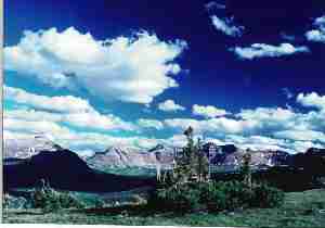
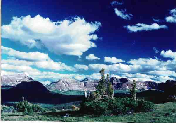
Prologue: Located in the Ashley and Wasatch-Cache National Forests, The High Uintas Wilderness, established by Congress in 1984, totals approximately 460,000 acres on the Wasatch-Cache and the Ashley National Forests. The Uintas are the highest range in Utah and the most prominent east-west trending range in the contiguous United States. The core of the range is Precambrian rock, over 600 million years old, composed of quartzite, sandstone, and shale. The crest of the range is a high, narrow ridge more than 60 miles long and rarely more than a mile wide at its base. This crest extends from Hayden Peak on the west to Leidy Peak on the east. Secondary ridges, as high or higher that the main divide, extend north and south from the main ridge. Below the main ridges, the range is divided into numerous alpine basins, dotted with picturesque lakes and meadows. Rivers descend from the basins into glacially-carved, "U" shaped canyons. Below the 10,000 foot timberline the area is forested with conifers, predominantly Englemann Spruce, subalpine fir, and lodgepole pine. The mountains rise out of the Wyoming and Uinta Basins that flank them to the north and south. Elevations range from 7,000 - 8,000 feet in the lower canyons to 13,528 feet atop Kings Peak (highest point in Utah). See the bottom of this report for additional background information.
For further information contact:
Ashley National Forest
355 No. Vernal Ave.
Vernal, UT 84078
Ashley NF: http://www.fs.fed.us/r4/ashley/recreation/highuintas.shtml
Wasatch-Cache National Forest
8230 Federal Building
125 South Stale Street
Salt Lake City, Utah 84138
Wasatch-Cache NF: http://www.fs.fed.us/r4/wcnf/
Highest point in each of the United States (America's Roof): http://www.americasroof.com/
Highpointers Club: http://highpointers.org/
Also see (a book): Davis, Mel & Veranth, John (1993). High Uinta Trails, Wasatch Publishers, Salt Lake, Utah.
USGS Maps traversed in this adventure:
Gilbert Peak, Mount Powell, Kings Peak (all 7.5 minute maps).
|
Wild Vagabond Main |
Trip Report Index  |
Caveat  |
|---|
As has become more typical, I will start each day's report with a word picture of some momentous episode of the day, then return to the daily report.
Day 1: Where Now, Alligator? (Henrys Fork Trailhead (9400') to Alligator Lake (10,033'), 4.5 miles, 5 ERM - Energy Required Miles.)
Commentary: Despite the rain, I froze in my muddy boot prints when I ran into the two deer lilting along the outlet stream from Alligator Lake. I became very aware that the cool rain water continued to leak through my sodden cowboy hat and down my neck, as I watched the deer wiggle their noses and rotate their ears, detecting what I was about. "Perhaps they're carnivorous deer, and they're deciding if I'm edible," I breathed softly. The deer appeared to decide that I posed some risk, because they trotted off into the mist among the tall Lodgepole Pines. And, I continued this, my first day in the Uintas this year.
The Day: I was mostly ready, speeding my departure from Smog Lake. It's 150 miles from Smog Lake to the Henrys Fork TH on the North side of the High Uintas Wilderness. It was raining as I greeted the seasonal ranger and his two rented llamas at the TH. He reported that he had not hiked over Flat Top, around to Red Castle, etc. but had been touring the popular Henrys Fork lake loop with little wandering. To me, this seemed like a narrow approach to the wilderness, especially for someone who had been in the Uintas as long as he.
I began hiking the trail above the Henrys Fork as the drizzle came down, dodging and stepping over the plethora of rocks so common to Uinta trails. After 4 trail miles, I came to the unmarked turn-off to Alligator Lake. Dark caved in before I could completely set-up camp on a low bluff shrouded in Lodgepoles above the Lake.
Day 2: Gilbert The Penultimate: (Alligator Lake (10,033') to camp (@11,200') a mile below Gunsight Pass, 7 miles, 8.5 ERM; scramble Gilbert Peak (13, 442'), 4 miles, 8 ERM; total of 11 miles, 16.5 ERM.)
Commentary: Gasping for rare air, I approached the 12,500' lip leading to the open, rock-studded rampart of Gilbert Peak, penultimate peak in the state of Utah. The state with "over-propagation of the planet" as its motto. Aren't 6 billion! people enough?!! (See the sites at the top of the page for the ghastly data.) Nose-to-nose with an Old Man of the Mountains dwarfish sunflower, I inched up to the rolled lip of this part-time couloir and pulled out my GPS, providing an excellent and much needed excuse to catch my breath. As I knew, the obvious peak that overhangs the pass is not Gilbert. Instead, Gilbert is over a mile and a half to the NE from my present position. On I plodded, over a lunar plateau of Uinta rock, eventually arriving at the summit. The 'easier' route is to hike up the ramp from near Dollar Lake. My feet were bruised and I was tired as I enjoyed the good views from Gilbert.
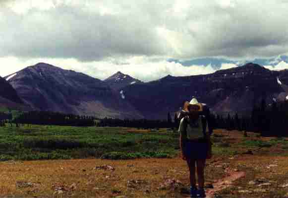
The Day: The weather was excellent as I hiked to Elkhorn Crossing, and, after crossing the Henrys Fork, it continued as I hiked ever upward toward Gunsight Pass. Along the way, I enjoyed glimpses of big mountains. This is the straight-line route to the pass, past Dollar Lake. I encountered a republican caucus of domestic sheep clogging a high meadow below Dollar Lake. Their caucus highlights thickly dotted the pruned-to-dirt once-meadow. Trees became more scarce and I camped about a mile from Gunsight Pass. After establishing camp in a tiny cove of wind-cropped firs, I headed for Gilbert Peak, second highest point in Utah. Ahh, to be penultimate in this pretty great state.
|
Day 3: Kingly Ultimate: (from camp (@11,200') a mile below Gunsight Pass (11,888') to Anderson Pass (12,450') to Kings Peak (13,528'), down couloir slide to complete loop; 10 miles, 16 ERM.)
Commentary: The Nth (at least 6th) squall slapped the top of the tent, and pelting ice or hail again bumped me out of a pleasant dream. "It must be nearly dawn" I muttered to myself. "No, it's that nearly full moonlight peeping in between clouds" I concluded. "And," I added, "It's a good thing the tent is ensconced inside these low trees - otherwise the winds would be slapping around the entire tent!" The remainder of the night, I dreamed of tornadoes on Kings Peak, tornadoes like the one that had recently missed its intended target of the lds office building in Smog Lake, Utah. I could see the brass-plated Moroni, frozen in the process of blowing his horn for all the faithful to multiply, uprooted from the temple at the center of the earth and whirling around in the vortex of the tornado with abandoned beer bottles, climbers sleeping in their tents, hoods and other parts from mormon assault vehicles (e.g., Suburbans, other vehicles capable of carrying more than 6), and other unidentifiable stuff. Wait, is that Toto I hear yipping in the swirl? Am I in Kansas? Yikes!
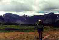
The Day: I awoke to clear skies over the Henry Fork basin, and a dark mulling mass over Kings, obscuring most of the peak. I thought to myself, "perhaps my dreams last night will come true today..." "Maybe it will clear off" my hopeful side noted. I packed lots of stuff in the pack, and headed up the trail to Gunsight Pass at 11,888'. After considering contouring high from the pass, SW, to meet the trail to Anderson Pass, I dropped on the trail into Painter Basin, enjoying the easy stroll through alpine-like tundra. Along the way, I encountered a young grouse, who almost posed for a photo. From the Painter Basin junction at 11,286', I began the broad shelf-walk to Anderson Pass at 12,450', significantly decreasing the remaining elevation to the top of Utah. Along the way, I refilled water bottles and began gorp stops.
At Anderson Pass, I sat in the lee of a rock outcrop and ate lunch mostly out of the gathering wind. Then I began the rock-hop to Kings Peak, which took about an hour up and less than this down. It was a day for good views, and I lounged awhile on the summit. America's Roof and the Highpointers' Club (web addresses above) list Kings Peak as the 7th highest in the U.S., and rank it 7th in difficulty, in regard to round trip mileage, vertical gain, elevation, and climbing classification. I considered my kingly perch overlooking Yellowstone Creek in Garfield Basin to the SW, Atwood and Painter Basins and the forks of the Uinta River to the East, and, of course, the Henrys Fork Basin to the North, and I classified what I saw as "wondrous," with special consideration to the lovely lack of developed anything.
Back at the pass, I contemplated three routes for my return to camp: 1) the way I came - back through Painter Basin via trail (longest, easiest), 2) the high route - contouring NE to Gunsight Pass, and 3) down the couloir - North toward Henrys Fork Lake, which is where I headed. The route plummets 1,000' directly down the fall line. It was OK going down, but I doubt it's the best way to come up or go either direction when there are wet conditions. From the bottom of the couloir, it's possible to go North to Henry's Lake, or, as I did, contour East and NE to camp near the trail from Dollar Lake to Gunsight Pass, above the marshy areas and below the rocky slopes. I straggled into camp, feeling joy about my lovely hike and feeling tired through to my aching bones. I had scrambled the big peak, the ultimate Utah highpoint, and the weather had held. The views across the basin, to Flat Top Mountain, were backlit by the salmon sun and the gangly remains of thunderclouds strung out along the horizon which looked like dragons coursing across the sky.

|
Day 4: Looping the Lakes: (From camp (@11,200') a mile below Gunsight Pass (11,888'), to Henrys Fork, Grass, Bear, & Sawmill Lakes and out to the TH at 9400'; 11 miles, 13 ERM.)
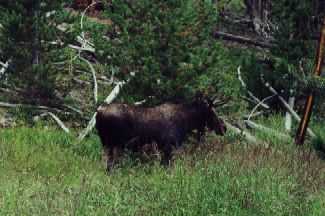
Commentary: Something dark and very large caught my peripheral vision as I stepped out from under the trees to mark a GPS point for the Alligator Lake trail junction. I refocused my eyes and there he was, a big bull moose less than 50' away. Awe and admiration quickly replaced my low-level startle response. I quietly watched as the moose eyeballed me briefly, then laid down in the high forbs along the Alligator Lake outlet, disappearing except for those substantial palmate antlers. Someone walking past would think nothing of this apparent dead fall protruding from the high grasses. After a few photos, the drizzle set in again and I slid back on the trail.
The Day: The morning brought intermittent rain storms, which continued throughout the day. I had planned to hike the lakes loop and stay one more night. But, the drizzle convinced me to walk out to the TH. The occasional drizzle upgraded to a full horizontal soaking as I looped above Bear Lake, and the water began running down my legs and filling my boots. About the time this storm paused, I encountered one of the few hikers to be seen today. Something about him, his ice axe plus what looked like a green tinge in his shaggy beard prompted me to dub him the 'Moss Man.' "How come?" you might ask. "Well, it just seemed correct," I noted. One might say "You are full of republican clear-cut mud, as honest as what Jim Hansen says about how timber welfare is good for us." I ask you to make a bet, but will you ignore me?
As I slogged along, two dark forms, a cow and a yearling moose, suddenly became visible through the ground-level mist and drizzle, interrupted my trail mantra. Wow, I am close to them. The cow stuck out her tongue, flapped an ear, then these behemoths were silently gone, vanishing before my eyes, somewhere in the thick trees.
It has been a wonderfully quiet day, and this continued at the TH, where I saw only 2 vehicles (there were 20 or so when I started). "Hey," I exclaimed to myself, and to you "here is the Moss Man's vehicle!" as I pointing a bit too smugly to a van from Washington. Told you so.
|
|
I crowded into the back of the collapsed campermobile, out of the falling mist, and changed into dry clothes before heading back toward Mountain View, WY. Along the way, near I-80 exit 31, I paused at Mrs. B's for dinner and to avoid the impending sunset glare through the windshield. I waited long after sunset, talking to assorted truckers, about great things such as giant moose, wild country, and big lovely mountains; and, despicable things like the congestion and construction malady, locally over-represented by Smog Lake. As the small pick-up truck engine droned into the night, I thought of mooses, peaks, flowers, sunsets, and the raw beauty one can find in a ultimate and penultimate wilderness.
|
Wild Vagabond Main |
Trip Report Index |
Caveat |
|---|
The High Uintas are Utah's magnificent mountain anomaly. Walter Cottam, one of Utah's preeminent botanists, noted in 1930 that "the Uinta Mountains represent Utah's only claim to a typical Northern Rocky Mountain flora." According to Intermountain Flora, the Uintas' area above timberline in a true alpine flora surpasses all of the alpine areas in the Intermountain West combined. Also anomalous, the range runs east and west for 150 miles across northeastern Utah; the core 55 miles of this wrinkled ridgeline rarely drops below 11,000 feet, with at least a dozen major summits soaring to over 13,000 feet (including Kings Peak, Utah's highest point at 13,528 feet.). Hundreds of glacially carved lakes dot small and large basins, some as high as 12,000 feet, others hidden in dense spruce and fir forests. While active glaciers no longer find refuge in the Uintas, these mountains are continually re-shaped by the harshest weather imaginable.
The North Slope is a gentle, almost plateau-like region of lodgepole pine forests surrounding meandering open parklands and high mountain meadows. River bottoms are wide and filled with willows, potholes and beaver ponds. A series of steep glacial stairs give rise to a belt of spruce and fir forests leading to the tightly packed krumholz of alpine basins. Looking into the South Slope, the heart of the Uintas, one fathoms the unique massiveness of this range.
Here huge glacial basins dominate the immediate landscape. Off in the distance deep glacial canyons lost in the long jumble of spruce and fir forests gently tumble down river basins into lodgepole pine and out into the sagebrush of the Uintah Basin.
Although it has only a few tree species (lodgepole pine, Englemann spruce, subalpine fir, small stands of ponderosa pine and Douglas-fir, along with a few deciduous hardwoods, aspen, birch, alder and willows), the range has great vertical and horizontal heterogeneity. These extensive forests make the Uintas unique in the Intermountain West.
This topographical variety and size allow the Uintas to harbor a diverse fauna, Canada lynx, black bear, cougar, wolverine (sporadic sightings), great gray and boreal owls, golden eagle, goshawk, osprey, pileated and three-toed woodpeckers, river otter, pine marten, Rocky Mountain bighorn sheep, moose, and elk. Grizzly bear, wolf, and bison once found a secure home in the Uintas. In this mountain sanctuary, the sensitive and native Colorado and Bonneville cutthroat trout still have a few isolated stream miles within which to hide.
Although fragmented by destructive Forest Service policies of timber harvesting, grazing, oil and gas development, predator control, as well as by state wildlife management activities focusing on game management, the Uintas have proven resilient. This range remains a biologically important and reasonably intact mountain sanctuary. Yet only a portion of it is actually protected. Historically, the Uintas were at the crossroads of development of the Interior West. First described by Father Escalante in 1776 and later by John Wesley Powell in 1869, the Uintas have been hunted by the Utes, trapped for beaver by the Rocky Mountain Fur Company, surveyed and studied by the greatest naturalists of the 19th century, Hayden, Agassiz, Gilbert, Cleveland, Leidy, Marsh, and more recently explored by increasing numbers of backpackers.
In 1931 a 237,000 acre portion of the Uintas was designated by the Forest Service as the High Uintas Primitive Area, almost exclusively above 10,000 feet. For over 50 years the Uintas witnessed a plethora of administratively proposed wilderness boundaries. Ironically, while these wilderness proposals have offered increasing acreages, the roadless nature of the range has been steadily eroded by logging and energy developments.
Please see the Council's web page for the end of this description and current problems and successes.
|
Wild Vagabond Main |
Trip Report Index |
Caveat |
|---|