
|
|---|
Trail sign, but no trail
(Click the image for a full-size view)
|
|---|

|
|---|
Toiyabe Columbine
(Click the image for a full-size view)
|
|---|
|

|
|---|
Toiyabe Crest Trail
(Click the image for a full-size view)
|
|---|
|

|
|---|
First view of Arc Dome
(Click the image for a full-size view)
|
|---|
|

|
|---|
Summit sign
(Click the image for a full-size view)
|
|---|
|

|
|---|
view North from Arcdom
(Click the image for a full-size view)
|
|---|
|

|
|---|
Aster on the Dome
(Click the image for a full-size view)
|
|---|
|

|
|---|
Screaming yellow on the Dome
(Click the image for a full-size view)
|
|---|
|

|
|---|
Trail 2028 disappears
(Click the image for a full-size view)
|
|---|
|
No one must be allowed in the wild outdoors
until he can prove he is ecologically housebroken. Paul Petzoldt, 1974
Day 1: Drive, drive more.. Nevada.
Day 2: North Twin Ramble; 9 miles,
3800' gain, 15 ERM. I'm sitting on a sun-warmed rock admiring the last of the daylight,
etched a greenish yellow where it plays across the lichen-drenched outcrops of a monster
bump that blocks my view of Arc Dome.
ERM is Energy Required Miles. As initially read in
Trails of the Tetons (long out of print) by Paul Petzold, founder of NOLS. It's a
wonderfully useful concept and application. Add one mile for each 500' up AND down to
distance = ERM. I frequently use ERMs to calculate what the actual day is like, unlike
Bruce Grubbs and other writers who may or may not have visited an area they write about (see
below).
Yesterday, was a driver, 550 miles to the TH, via I-40,
hwy 93, then 95, then Nevada 376. I saw a "new" arch in the basalt outcrop about 50 miles
North of Kingman. On and on, pausing for lunch near the Nevada Test Site, old abandoned
road to doom. To Tonopah, where I called K who leaves on a girls' vacation in a few days.
On into Smoky Valley and eventually the TH. There's lots of wind, so I sleep in the back
of the truck.
Wind again in the morning after a warm and poor evening.
I'm walking to N Twin TH when I meet Chris of Las Vegas and we talk about the route. He
is the only person I see today.
Crawling up North Twin trail, I am fording often, but
no wet feet. That's a Nevada "River" for you. The crags give way to temptations of
grand vistas. Gyrfalcon screech at me while I eat lunch at the junction with the Werdenhoff
Pasture drainage.
Downed trees complicate the route. At the next drainage,
I take trail 2028 and things go well until I find a good trail that leads to a wall tent,
a hunters' camp. The trail ends. I wander for awhile and eventually find what there is
to it. Brush-covered but not bad going, up and up through Mountain Mahogany, sage, some
Aspen and Water Birch. I go off route, or maybe the route disappears, and I stop to camp
where a spring feeds the small stream.
My GPS says I'm about a mile from meeting a branch
off the Crest Trail - about 1500' up?
My plan now is to day-hike to Arc Dome,
leaving camp in place. Steve Jarbidge says Columbine CG is where most people
start their Arc Dome adventure. Not me. Tired and a bit chilled, off to bed
I go.


|
|---|
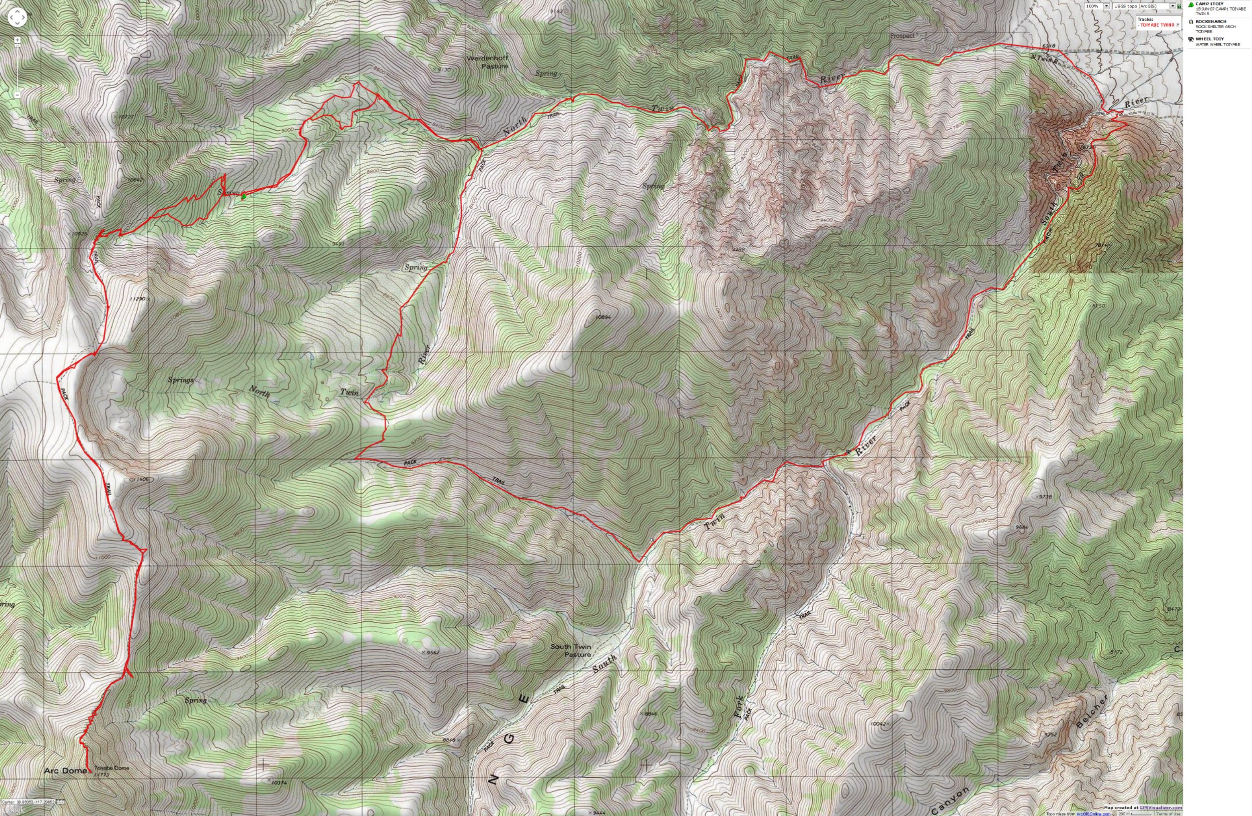
Map - NV: Toiyabe: North-South Twin Rivers Loop - plus Arc Dome; 30 miles
(Click the image to see the map)
|
|---|
|
If you want to view a full-resolution map, click here. Caution - do not use this map or gps track for
navigating the route.

|
|---|
Water wheel/Ore Crusher
(Click the image for a full-size view)
|
|---|

|
|---|
S.Twin Gorge and basin
(Click the image for a full-size view)
|
|---|
|

|
|---|
Basin and Range, Toiyabe Front
(Click the image for a full-size view)
|
|---|
|

|
|---|
Old tree glphy tr. 2028
(Click the image for a full-size view)
|
|---|
|

|
|---|
Rob & friend at TH
(Click the image for a full-size view)
|
|---|
|

|
|---|
road to doom
(Click the image for a full-size view)
|
|---|
|

|
|---|
How come it's called the Nautilus Eyebrow
(Click the image for a full-size view)
|
|---|
|

|
|---|
Nautilus Eyebrow Arch
(Click the image for a full-size view)
|
|---|
|

|
|---|
Detrital Arch through Nautilus
(Click the image for a full-size view)
|
|---|
|
Day 3: Arcdom: Arc Dome; 11 miles, 25 ERM,
roll along the crest. The way down is much easier than the up, but not because of
elevation gain/loss. It's because I found the whole trail coming down. I started
hiking at 7:30 a.m. and returned to camp around 5 p.m.
The cairn near camp signaled good stuff that
almost materialized. I found an old "Trail --->" sign and tried to follow it up.
If only I'd looked left as I walked off the brush-choked corner and headed back down,
believing this was an alternative route to the spring area. After a half a mile of
brushing, I popped up and encountered the end of the trail on the map, sighting by GPS
and dead reckoning (on the map, the trail ends about a half a mile after leaving
the crest).
The rest was like a highway as I rolled along the
tundra, views opening and ranging into California. I joined the Crest Trail where
it loops one of the accesses to Columbine CG and continued to Arc Dome, then left it
where the Crest Trail apparently drops briefly on the Stewart Cr. Trail. I was up
over 10,000', then lost much in the deep saddle prior to Arc Dome - the reason for
the high ERM, besides it being tall. Tundra flowers, warm enough for a t-shirt, no
one around. Glorious. I would later see four people, two going to the peak and two
looping around from Columbine CG. Only homemade signs, or none at all. Much of the
route is open with only cairns to guide you.

|
|---|
Detrital Arch
(Click the image for a full-size view)
|
|---|

|
|---|
Another view - water wheel
(Click the image for a full-size view)
|
|---|
|

|
|---|
Getting sranger, then...
(Click the image for a full-size view)
|
|---|
|

|
|---|
Getting there
(Click the image for a full-size view)
|
|---|
|

|
|---|
Almost there
(Click the image for a full-size view)
|
|---|
|

|
|---|
There you are
(Click the image for a full-size view)
|
|---|
|
Day 4: Loop Knock-Out: (? Mile, probably 8+,
? ERM). (My GPS reports that the total trip mileage is 31, with a total ascent of 9633'.
The high point was reported as 11,782' and the TH low was 6263'.)
Note that, once again and as is typical in all of his work
I have encountered, Bruce Grubb's (Hiking Nevada, 1994)
mileage estimate of this loop hike is way off (at 8 miles). It's difficult to tell where
he gets these highly erronious figures. A bit more reasonable is the 13 and a half (plus
another mile of road between the THs) estimate from Michael White's Nevada Wilderness Areas,
1997 - Chapter 10, Arc Dome Wilderness. Neither account for ERM, Energy Required Miles,
a concept which all guides should adopt.
ERM is Energy Required Miles. As initially read in
Trails of the Tetons (long out of print) by Paul Petzold, founder of NOLS. It's a
wonderfully useful concept and application. When I hiked the Teton Crest, I discovered how useful
this methodology is on the ground. Add one mile for each 500' up AND down to
distance = ERM. I frequently use ERMs to calculate what the actual day is like, unlike
Bruce Grubbs and other writers who may or may not have visited an area they write about.
My feet are humming as I watch the evening's glow
slip up the slopes across the basin. Basin and range, Basin and range, repeat.
I'm a bit giddy after my 1 and half beer at the
South Twin TH. The cooler drains as my stomach churns on chili, crackers, tuna, banana,
cherries, watermelon, and of course, beer It's been a long, pounding day, knocking out
the remainder of the Twin Rivers Loop.
I started before 9 a.m., from my Trail 2028 camp and
eventually learned where the trail ran (see the north segments of the tiny loops on the
GPS route). Then, upon reaching North Twin, I thought the walking would be smooth. Next
up, scores of downed Aspen to climb, disappearing trail and such. Up on the pass, I
wondered if the route might improve. Hah, it completely disappeared in the sage below
the pass and I put back on pants, not because it's cold, but because my legs are getting
whipped, cut, shredded, etc.
After much thrashing on this route (not a trail), I
encounter the relative highway of the S Twin Trail, headed for Reese River. Not far
and I see an arch, back and forth, across this so-called river tot he water wheel/ore
crusher. Lovely darting trout grace the crisp and clear waters of the North and South
Twin Rivers. Perhaps they're the fabled Lahontan Trout? The lower South Twin gorge
is a deep, dark splendor. It requests further investigation. Up around the narrows and
I'm feeling enervated and more. Big gopher snake but no people, even as I write and the
light fades. I look out across the purple hills and feel refreshed after my sun shower
and beer.
Day 5: Driver: I crawl through the terrorist
junction known as Hoover Dam, noting huge arching spans to nowhere cluttering the sky,
ending abruptly hundreds of feet above. I guess a new highway is under construction over the dam.
I stop and walk up to the Nautilus Eyebrow Arch.
Las Vegas, another sprawl that has no compelling reason to exist, where a green belt
is a republican developer's money belt, where rare desert water is sprayed into the
air like so much pyrite (fool's gold) thrown into the air by early Nevada prospectors,
where the a church has a firm hold on ecological suicide via overpopulation. A place
to avoid. But not the Toiyabes, a place of intrigue and mystery. Anyway, the "trails"
could use a tiny bit more traffic.
Edward Abbey once wrote: "Wild country has the
power to remind civilized people that out there is a different world, older and greater
and deeper by far than ours, a world which surrounds and sustains the little world
of men."
South Twin Rivers Rock Shelter arch, Nevada - directions:
See these features marked on the GPS track below Day 1 above.
The name for this arch was derived from where it is and that
there is what appears to be a rock shelter below the arch.
Drive about 65 miles North of Tonopah, Nevada, on Nevada Highway 376.
Take Forest Road 080 West to the South Twin Rivers Trailhead, which is about 3 miles
off the highway. Approximate coordinates for the TH are: UTM 11 S 479150E 4304413N (WGS84).
Hike up the South Twin River Trail that goes steeply up the side hill East of where South
Twin emerges from the narrow canyon for approximately 5.5 miles. Do not begin by hiking up
the river. You will be a few hundred yards NE of the junction of the South Twin and North
Twin River trails. (Caution, the North Twin River Trail exists mostly on the map, not the
ground.) The arch is NW of and near the trail, at about 7900'. The approximate gps
coordinates for the arch are: UTM 11 S 474660E 4300431N (WGS84).
Of interest to some hikers, is an old water wheel
and ore crusher about 3 miles up the South Twin River trail, just downstream of the
confluence of South Fork Twin and South Twin River. The wheel still turns! The wheel
is approximately at: UTM 11 S 476524E 4301252N (WGS 84) and 7300' in elevation.
Nautilus Eyebrow Arch, Arizona - directions:
Bonus - Detrital Arch, Tres Compadres Arches
This arch can be viewed from mile post 21.6 on Hwy 93
about 50 miles North of Kingman, Arizona. The mile posts are numbered from the Northern
border with Nevada, near Hoover Dam. The coordinates from which to view the arch to the
West are at approximately UTM 11 S 723623E 3963505N (WGS84).
The Nautilus was the fabled submarine from Jules Verne's
Twenty Thousand Leagues Under The Sea. This arch looks like the 'eye' of the Nautilus,
thus the name. On the slope below Nautilus, one might see Tres Compadres, a series of
three tiny arches.
Detrital Arch: Driving North about a quarter of a mile,
another arch is visible in a protrusion about a mile to the West. This arch can be seen
in the photo looking through Nautilus Eyebrow, and was dubbed Detrital Arch because of
the wash near it. Detrital refers to particles of rock derived from the mechanical
breakdown of preexisting rocks by weathering and erosion.
|
|
|---|
Map - NV: Toiyabe: North-South Twin Rivers Loop - plus Arc Dome; 30 miles
(Click the image to see the map)
|
|---|
|
If you want to view a full-resolution map, click here. Caution - do not use this map or gps track for
navigating the route.
Friends of Nevada Wilderness
Arc Dome
Wilderness from Wilderness.net
Austin Ranger District -
Toiyabe NF
| | |


