(Click the image for a full-size view (41k); Photo by Rob)
|
|
|---|
|
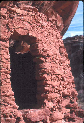
Ruin, somewhere on the Colorado Plateau
(Click the image for a full-size view (41k); Photo by Rob) |
Prelog: Slickhorn Gulch adjoins the Grand Gulch Primitive Area (BLM) in South-east Utah. On the Utah map, find Natural Bridges National Monument along Hwy 95 between Hanksville and Blanding. North of the NM is the Dark Canyon area, while Grand Gulch/Slickhorn is to the south. There is a fine day hike to the large natural bridges in the NM.
|
|---|
|
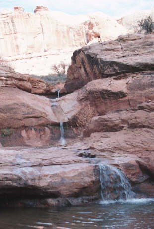
Slickhorn somewhere
(Click the image for a full-size view (33k); Photo by Rob) |
Day 2: Access #6: We completed the last of the packing on our spacious kitchen rock, that was large enough on which to park the car, and drove to the corral at the top of Access #6. Today we would hike down Access #6 canyon to about a mile below the mouth of Access 6 in the main gulch. It took about 3 hours to hike from the corral to the main gulch camp. What a delightful canyon #6 is. It's a classic slickrock canyon. We saw 2 married to each other females, one guy, and one dog in the gulch. There was water running down the gulch and lots of cooler-than-normal wind. Down from the mouth of #6, we encountered some Claret Cup Cactus blooming, and some Mormon Tea (blooming?). There were loads of yellowish tiny buds or flowers that looked like pygmy pine cones on the tea. The wind continued. We found a nice camp site in a right-hand bulb of the gulch, just below the next side canyon below #6. It's great to be back in church.
Day 3: Plunging To the San Juan: It's a calm morning and some azure blue is breaking through. Sherrod and I relished some "extra" time in bed while my poorly-working stove slowly heated a pot of gulch water. I later dismantled the stove, cleaned, then changed the jet, but I could not pull out the fuel tube cable, and I wasn't able to get it running at high intensity during the rest of the trip.
Back in Smog Lake, I had to hook the stove in the fence, spray the fuel tube with carburetor cleaner, and pull on the cleaning cable with pliers and two hands. I later bought a new cable and jet (to replace the one I apparently lost in the Gulch).
We hiked to the San Juan River, and back. It was a calm morning but the wind later joined us. After traversing a boulder-invested section with shale layers and big jumps, which we encountered just before the river. There are delightful large and deep turquoise plunge pools in this final stretch to the river. We would not see anyone until we encountered Kim, a river man for Moki Mac river outfitters (Smog Lake).
Below camp, the route zigs through willows, rocky stream beds, boulders, over and around ledges, and skirts huge plunge pools. The ledges in the lower canyon were like Elephant Canyon Shale, a smooth, blue plate of elegant rock. It took 6 hours to get to the river, and a little over 4 hours to return, where we arrived at camp just in time for sunset. While at the river, we snacked on smoked oysters and assorted gorp. Kim pointed out the ruins of an oil rig and the Honaker Trail (once a 4WD route, now a trail). Kim also told us that the San Juan is one of the fastest-moving rivers in the U.S. It was running just above average flow, but looked like it was really moving. Tired, I had just enough energy for a cool shower in the gathering dusk. We were a bit too tired to sleep well.
Day 4: Snow climb: The graupel woke us around 6 a.m. It grew quiet. Ahh, it's stopped, I thought as I snuggled back into that drifty almost-sleep state, nestled in my cozy bag. It was snowing giant soft flakes. There were 3-4" of this desert white before we got packed and headed out. It was very quiet as we wandered through the willows, then up the canyon, knocking off the white fluff as we traveled. The snow muffled any sounds and prevented echoes, adding to the wonderful solitude. Starting up Access #6, I often wore a polypro top and soaked Sinclair pants. It was too warm for an anorak while walking, but shivering cold when we stopped. We spotted new, to us, ruins high in the North wall near the pour-off you must climb around.
We were at the Subaru by noon and headed the long way home after stashing mud-laden boots and anoraks and driving the 7.5 miles to the tarmac. Surprisingly, the gulch road was in great condition, although I suspect that another load of water might have made it a clay-ball festival. It rained to Hanksville, and the ground-level clouds obscured the plateaus, even Jacob's Chair and the close-to-the-road Cheese Box. "This has been a great trip" we noted as we paralleled the rows of San Rafael Reef teeth. We enjoyed dinner at the China City Cafe in Price, and made it home by 8:30 p.m. Smog Lake had reportedly been shrouded in cool rain during our absence.
It is said that one can walk along a ledge above the San Juan from the mouth of Slickhorn Gulch to the mouth of Grand Gulch. Say, what a monster of a trip that would make....down Grand Gulch, along the river, partially looping back via Slickhorn. Now, there's only that slight shuttle to consider, and food, and........
|
Wild Vagabond Main |
Trip Report Index  |
Caveat  |
|---|