
Touring Northern Idaho, British Columbia (Canada), and Eastern Washington
Sandpoint, Idaho - Bonners Ferry, ID (37.8 miles) - Creston, British Columbia, Canada (40.1 mi.)
- Crawford Bay, BC (51.1 mi.) - New Denver, BC (53.2 mi.) - Nelson, BC (61.0 mi.) - Salmo, BC (27.0 mi.)
- Metaline, Washington, (29.0 mi.) - Pioneer Campground, WA, (58.0 mi.) - Sandpoint, ID (44.4 mi.)
The VM (Venerable Monster, Specialized Expedition Touring Bike, circa 1984) Rides Again!
Text © copyright by Rob; and Photos © copyright by Rob Jones, Dave Rumbellow
|
| |||||

|
| |||||


| ||||

"It is by riding a bicycle that you learn the contours of a
country best, since you have to sweat up the hills and coast down them. Thus you remember them as
they actually are, while in a motor car only a high hill impresses you, and you have no such accurate
remembrance of country you have driven through as you gain by riding a bicycle."
- Ernest Hemingway, By-Line (book spans the period 1920-1956).
Summary: This is a report about a 400 mile self-contained
bicycle tour of the International Selkirk Loop, which travels from Northern Idaho, into British Columbia,
Canada, and into Eastern Washington, circling the Selkirk Mountain Range. Three of us rode the main Selkirk
Loop and the North Kootenay Lake and Silvery Slocan side loop; Balfour to Nelson.
co-participants: Dave Rumbellow, Cheryl Soshnik.
Distance: 401.6 total miles (My very old odometer reads
low, so it is likely a bit more than 401 miles.)
This was to be an exploratory ride, to ascertain whether the
'chamber of commerce' approach rules the loop, or whether there are decent camping opportunities for
a larger group. Mostly, there are decent options.
This was a delightful adventure, despite the moss and fungus
conditions, made possible by veteran bikers and all-around good sports and supportive riders,
Cheryl and Dave. I particularly enjoy their good cheer and reciprocity. I organize a trip
and invite you, you organize a trip and invite me.... so rare these days. Other riders wanted to
join in, given Cheryl's phenomenal planning skills, yet were unwilling to help out.
| ||||

| ||||
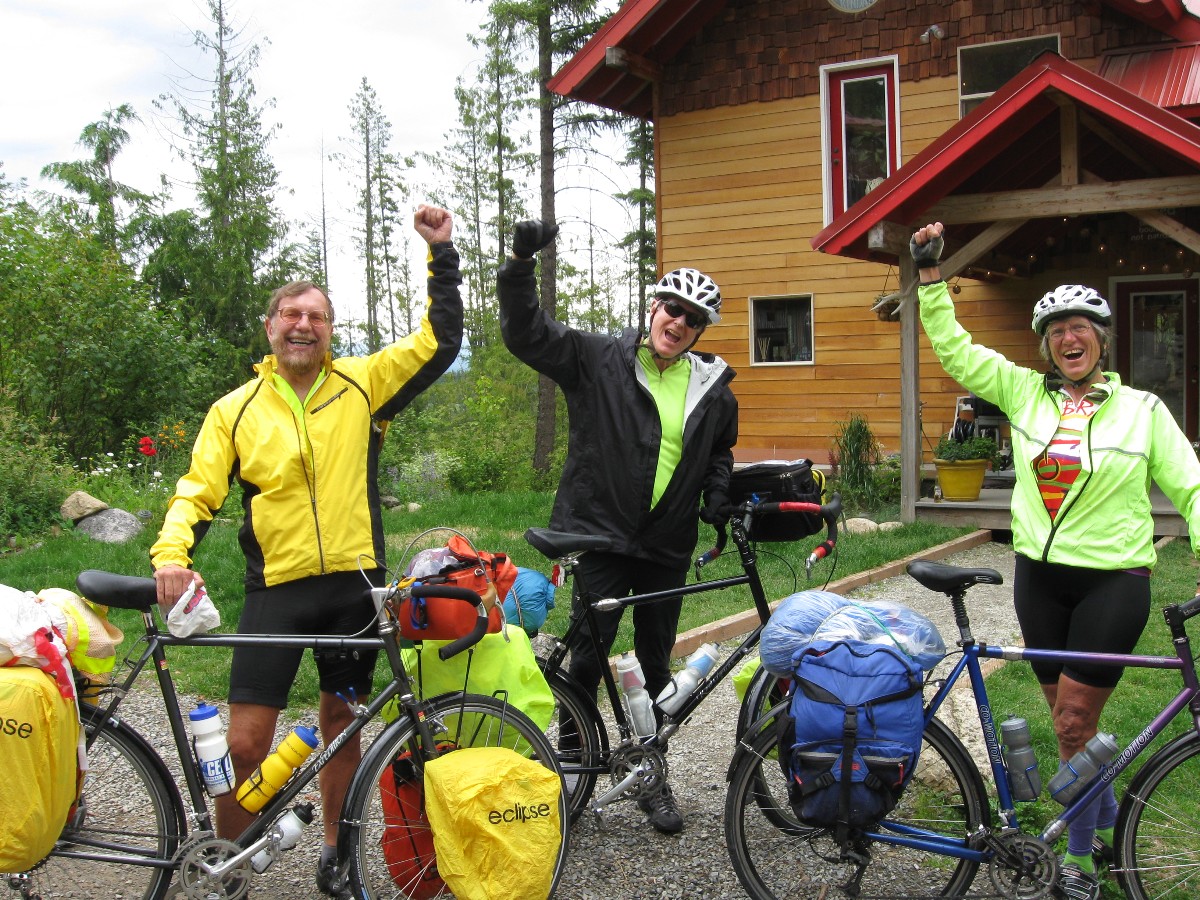
Prelim: A long ride in the car with Cheryl and Dave brings us to Matt and Kendall's cabin outside Sandpoint, Idaho. Over 700 miles. I stretch out the Marmot bag on the 2nd story unfinished (no rails) deck and enjoy a fine evening.
It's been a bit over a year since I stopped in at the rest area near
the old homestead outside Malad, Idaho, and saw the Selkirk brochure. This might make a fine bicycle tour, I say
to myself, and later to Cheryl and Dave. To this point, all I knew about the Selkirks was something vague
about the Selkirk Caribou, and how their habitat is in trouble
(so, what's new in the land of vanishing species?).
BC and a few counties in Idaho and Washington has the world’s
only mountain caribou and they live in the Inland Rainforest Region. The mountain caribou depends
upon old-growth forest for its survival. As a result of excessive logging, it is in serious danger
of going extinct. With almost 100 animals, the Central Selkirk herd is the most viable of the
southern herds. After three years of a federal-provincial recovery process for mountain caribou,
there has been no increased protection of the old-growth forest used by these animals.
One can certainly link the geometric explosion of the human population
and consumption to the demise of most everything else.
Day 1: Rain and Shine, Idaho: Sandpoint, Idaho
to Bonners Ferry, Idaho; 37.8 miles. June 25th.
Starting off from Sandpoint, we ride the wet gravel back to US 2/95 and across
it on Selle Road, journeying away from this over-used road. We're riding full-weight touring bicycles, replete
with tents, stove, emergency food (for when we cannot find stores along the way), clothes, a host of equipment.
My bike weighs in at about 75 pounds, I guess. Still, it is a liberating feeling, riding this loaded,
self-propelled conveyance of exploration.
White Tail Deer pop up in the high grass like rabid jack rabbits. Two
young horses, an appaloosa and a mustang run, buck, leap alongside as a low fence separates us. It's Idaho,
rain and shine. More rain than usual, producing lush grass and roiling rivers.
Lightning brings rain and we hide under a large conifer at the edge of a
cemetery and wait. Shower cap on - over the helmet, rain covers on the pannier and the body. We venture
out and ride in a fine mist. Back on Hwy 2/95 we are sprayed by big trucks and winnehogos, despite there
being no active rain. Off on the Deep Creek Loop Rd and into glorious country. A lunch pause at Naples
refreshes. Then, on around to where Deep Creek Rd rejoins 2/95 and quickly into Bonners Ferry. We've
avoided all but about 13 miles of the horrid 2/95.
A stop at the International Selkirk Loop office to meet Carol and discuss
route options. Educational. Trying to find the Selkirk Loop office, I talk with a county sheriff, who
notes that we can stay at the County Fairgrounds. After checking out the Boundary County Fairgrounds, we
roll to Kootenai River Brewery for beer and a salmon burger - then back to the fairgrounds for a water bottle
bath and some excellent sleep.
"Life is like riding a bicycle. To keep your balance you must keep moving." - Albert Einstein

Soggy Selkirk Day 1 - photos by Rob


 office.jpg)


Day 2: O Canada! Bonners Ferry to Creston, BC, Canada; 40.1 miles.
Today turns out to be the day with the most sludge in this soggy Selkirk Soiree. Rain and more rain, we ride through a refuge, including a 5-mile gravel/dirt stretch of road.
The cool rain rolls in waves from my shower cap-shrouded helmet and drums on my already cold nose, propelled by the North wind and a vigorous downhill. "Almost to Canada," I mutter, as my waterproof mitten shells pool water around my prune-surface fingers. Argh! Wet, very wet, most everything is wet, I muse, yet hope the bagging and pannier covers have done their prevention work. Stopping at Canadian Customs, Cheryl pours a pint of water out of the bag covering her handlebar bag. I feel moss growing behind and in my ears. "Oh Canada, we'll grow some moss for you; Oh Canada, a bit of hypothermia too!" (sung to "O Canada," with chattering teeth).
O Canada!
Our home and native land!
True patriot love in all thy sons command.
With glowing hearts we see thee rise,
The True North strong and free!
From far and wide,
O Canada, we stand on guard for thee.
God keep our land glorious and free!
O Canada, we stand on guard for thee.
O Canada, we stand on guard for thee.
True to their reputation as a friendly people, the Canadians at the border crossing
share some good cheer and a double wrap of pink cord to replace the missing drawstring from my rain pants. The pants
have been falling down around my ankles when I'm off the bike.
The day starts early at the fairgrounds, mammatus clouds hanging pendulous across
the Southern horizon, prompt us to roll. Out the Riverside Road and into the Kootenai Wildlife Refuge on the West
side of the River, and the aura and claustrophobic greenery enrich a desert dweller. Gorgeous! Green,
interlaced with green and more green. A velveteen moose trots the sparsely-traveled road as we cruise.
Because it's now raining, none of us has out the camera, and the memory will have to do. Crossing rushing streams,
we bypass the bike loop of the refuge. We're on gravel now, and the once-poofy dust is now a slurry of mud akin
to valve-grinding compound. On go the rain pants and plastic bags over the socks, yet don't seem to help much. Wet.
At 22.4 miles from Bonners Ferry, we're on Hwy 1, near MP (milepost) 1.
Quieter now, or at least today, there is none of the texas terror encountered yesterday on the 2/95. Now on
Canada Hwy 21, we'll leave Creston on 3A. More rain. We have done little hill riding so far on the Soggy Selkirk.
"I feel that I am entitled to my share of lightheartedness and there is nothing wrong with enjoying one's self simply, like a boy." - Leo Tolstoy (In response to criticism for learning to ride a bicycle at age 67)
Soggy Selkirk Day 2 - photos by Rob
 |
 |
 |
Day 3: Serpentine Sasquatch; Wind and Roll all Day: Creston to
Crawford Bay; 46mi. + 4.5 in Creston and 0.6 in Crawford Bay = 51.1 total miles.
Today, I see my shadow - at least twice - while rolling and winding along the
shore of Kootenay Lake. It's cool, yet so much more pleasant than the sludge horror of yesterday.
The day stars with a quick visit to the Columbia Brewing Company and Sasquatch.
Then, on the highway, now 3A, and climb and roll easily (by most bike tour standards) to Wynndel, to Sirdar, and
Kuskonook.
We pause at the Glass House, made from many thousands of embalming fluid bottles,
and eventually into Boswell. Some of the proffered eateries are closed, yet we enjoy a snack while leaning against
a highway barrier. More riding, then into Crawford Bay (Kokanee Chalet and CG), where I work more on the bike -
still removing the valve-grinding compound from the front derailleur after yesterday's mud ride. I've been
restricted to the middle chainring gears today. We share our camp today with Sheryl and Doug, bike tourists
from Napa Valley.
A core-warming hot tub soak is lovely. Gorgeous visions of clouds suspended
in rows against the mountains lull me to sleep.
Soggy Selkirk Day 3 - photos by Rob
 |
 |
 |
 |
 |
 |
 |
 |
 |
 |
 |
 |
Day 4: Balfour to Boufous Bear: Crawford Bay to New Denver;
53.2 miles. Begin the North Kootenay Lake and
Silvery Slocan (110 miles) side loop to the Selkirk Loop; Balfour to Nelson.
Cheryl and I are resting from the 16 (so far) mile gentle climb out of Kaslo
and headed for New Denver when the Boufous Bear (Ursus Americanus, the American Black Bear) silently pads
across the road just downhill and where we just were. Boufous Bear! Ursa! Lovely Boufous.
We're grinding up and up the pass, after sharp ups and downs from the Ferry
(Balfour, Canada) to Kaslo. Dave is up and ahead somewhere, riding strong.
I wake to a dew-laden tent, yet sunny skies and we hurriedly pack and ride
to the Ferry. Got to make the 9a. ferry so we have riding time today. We are among the first to load the
Osprey 2000 Ferry, and begin to stroll the sitting and viewing areas as the cars load. The Kootenay Lake
Ferry is the longest free ferry ride in the world and well worth the voyage for the view alone, especially
if it's your only opportunity to get on Kootenay Lake in a boat. The Kookenay Lake water, very high - like
all local streams and rivers - moves quickly enough to form a visible current.
Then, we leave the ferry and begin the up and down roll along Kootenay Lake,
punctuated by snow-capped peaks, to Kaslo, home of the old sternwheeler boat, the Moyie. Along the way, we
pause at Ainsworth Hot Springs, yet decide to not soak - because how will we ride with rubbery legs? At the
HS, we meet Sam and Carter, young high school riders, enjoying a weekend of bicycle touring from Nelson to
Kaslo and back. It's refreshing seeing youngsters out touring rather than building fat while engrossed in
facebooking.
About the Moyie: The Moyie began service on the Nelson-Kootenay Landing Route on December 7, 1898, to connect with the newly completed rail line from southern Alberta through the Crowsnest Pass to the lower end of Kootenay Lake. The Moyie operated on the Nelson-Kootenay Landing Route as the major vessel (the "Crow Boat"), providing the service until the construction of the larger and faster S.S. Kuskanook in 1906. It appears that the Moyie strayed little from the "Crow Boat" service during these years except for operation on the occasional excursion. The Moyie connected with the trains, its Dining Saloon providing the sole eating facility on the service. By 1900, however, buffet cars were included in trains to Kootenay Landing. After completion of the Kuskanook in 1906, the Moyie was assigned to secondary routes from Nelson or Procter to Kaslo and other smaller communities along the shore of Kootenay Lake.
Dave, Cheryl, and I discuss staying at the municipal CG in Kaslo, a very festive
place - Kaslo is filled with art and history. After lunch at Eric's Deli, we note that the sun is out and begin
the climb out of town and toward the Fish Lake Rest Area (the true high point, not at Retallack). It's mostly
down to New Denver and the Centennial Municipal CG on Slocan Avenue in New Denver. Although riding the waterlogged
loaded Specialized Expedition (circa 1984), I achieve speeds of 38 MPH on the way to New Denver, yahoo. Coursing
through the swales of roiling streams, the warmth of the day immediately chills, temps dropping 30 degrees in a
matter of meters. Frigid, yet confined.
I'm almost too tired to think about dinner, yet do so. I again meet Sheryl and Doug
at the food mart - they are staying in a cabin because of predicted morning rains. Imagine that? Morning rain?
Soggy Selkirk Day 4 - photos by Rob
 |
 |
 |
 |
 |
 |
 |
 |
 |
 |
 |
 |
 |
 |
 |
 |
 |
 |
 |
 |
 |
 |
 |
 |
Day 5: Sultry Slocan: New Denver to Nelson; 61 miles. Complete
the North Kootenay Lake and Silvery Slocan side loop to the Selkirk Loop.
Yahoo, I'm gliding downhill, the thick air cool and getting cooler, cooling
the hot and sticky flesh after some good climbs out of New Denver. It seems the humid air is so dense that we
plow through it. And the views of ice-carved peaks threaded with pregnant clouds rising from Slocan Lake - lovely.
We're on the West side of the Selkirk loop, and headed South.
It's a low granny gear climb, followed by a rolling down, past throbbing rain-
and snow-fed streams to Slocan. Then, the increasing traffic, until 3A, is nightmarish. Rain (surprise?) along
the way, yet Dave and I hide out in a petro station while Cheryl is under a bank awning during the worst half
an hour. Hoorah! We arrive at the junction of Hwy 6 and 3A after about 50 miles of sun, rain, and hills and
decide to take the back route rather than the texas-style 3A. Canadian drivers so far have been very courteous.
Not so on this section of the 3A. Trained in texas, with the texas selfishness and republican ways. Horrid.
Then the real "fun" begins as we cross the Kootenay below a dam (Lower
Bonnington Dam?) and begin the steep and tedious hills to Nelson. Some hills have a 10% grade. Argh.
This twelve miles is difficult and takes quite awhile. Clammy and now cool, we arrive in Nelson to a
street fair (preparing for Canada Day) and make our way to the municipal CG, where we get the last tent
spot (because of a cancellation - most likely the rain helps here). After all, Canada Day is Monday. "O Canada....."
Kono the chocolate lab rescue dog entertains us as we set up camp,
enjoy hot showers, and write journal notes and read in the covered common area. Terrific idea, these
municipal CGs. It intermittently rains hard through the night.
Soggy Selkirk Day 5 - photos by Rob
 |
 |
 |
 |
 |
 |
 |
 |
 |
 |
 |
 |
Day 6: Zero Dayze: In Nelson, 0 miles.
People are asking, so I roughly total our touring miles so far, 243.
Today, we explore some of Nelson, visiting the trolley barn (the trolley
is not running because of soggy ground), the riverfront trail (some actually in the river, not along the river),
the library (and a good thing too, because I need to confirm my participation in the 2012 Grand Canyon service
project this October).
Of course, it rains, during which I catch-up on trip notes in the camp common
area, thankfully covered. More rain showers arrive near sunset and I listen to a bit more Martin Cruz-Smith
(Three Stations) on the podder.
Soggy Selkirk Day 6 - photos by Rob
 |
 |
 |
 |
 |
 |
 |
 |
 |
Day 7: No Salmon in Salmo; O Canada: Nelson to Salmo; 27 miles.
The three of us are crowded into a one-holer FS outhouse, avoiding what Cheryl
calls "another torrential downpour," a disturbingly and depressing repetitive theme of this soggy soiree.
We've waited out the second downpour of the day before getting all the way out of Nelson - hiding under
the large chestnut trees near the junction of Hwy 6 and 3A. The first rain? We were still in camp, so
avoiding the first rain was easy.
It's a steep climb out of Nelson, then rollers followed by a lovely lilt
downhill - yet this special time was spoiled by continuing, repetitive, omnipresent rain and more rain.
Dirge of deluge.
The day started on a better note, with sun and drying time and a pancake
breakfast and a peek at the Canada Day festivities. It ends well too, as we enjoy and relish in Cheryl L's
hospitality, good food, and a warm shower in Salmo. Cheryl L. is a member of the Warm Showers network,
a giving group of supporters of bike touring. Thanks Cheryl!
"Salmo?" you say. Apparently, when the crazed for development at any cost
types built all the dams - they wiped out the Salmon, so this city, Salmon Siding, dropped the "n," as in no Salmon,
but Salmo. There were no Salmon to side with, so the Siding went too. Sad indeed.
Soggy Selkirk Day 7 - photos by Rob
 |
 |
 |
Day 8: Border Gruffians: Salmo to Metaline, Washington; 29 miles.
Like a troll under the bridge, the border crossing gruffian yells at everyone
"out of the portal, move out of the portal!" The "portal" may be some sort of radiation scanner, or a wormhole
to texas, where one can easily escape prosecution as a war criminal. Nary a smile, certainly no joking here.
A tremendous contrast to what we experienced at the Canada crossing near Creston. I guess when your nation
has plundered the world, its bankers have destroyed countless lives, and its politicians have insisted on
compassionate conservatism that benefits only those of the right religion and the right income bracket, well,
then others don't like you much and fear is a political ploy and more.
We wait and wait while the gruffians are focused on a moderate-size camper,
then cross into Washington on the way to Mataline, WA.
We start today, Day 8 of the mossback ride, with breakfast and good conversation
with Cheryl L. of Salmo. Then, it's climbing to the border, and at times I can see my shadow - a startling sight.
We drop into Metaline Falls (the falls are now submerged) and then Metaline.
"When man invented the bicycle he reached the peak of his attainments. Here was a machine of precision and balance for the convenience of man. And (unlike subsequent inventions for man's convenience) the more he used it, the fitter his body became. Here, for once, was a product of man's brain that was entirely beneficial to those who used it, and of no harm or irritation to others. Progress should have stopped when man invented the bicycle." - Elizabeth West
Soggy Selkirk Day 8 - photos by Rob
 |
 |
 |
 |
 |
 |
 |
 |
 |
 |
 |
 |
Day 9: Up Your Pend Oreille. Storm Dodger: To Pioneer CG
(near Oldtown ID; Newport, WA); 58 miles.
The twisting turbulence of wind swirls and plows into me head-on, stopping
the bike and nearly lurching me into the Pond Oreille River for a deep swim. Arresting development. Yikes.
We're twirling pedals as we enjoy the Le Clerc Road (old highway), a fairly quiet road that rolls upriver
from just South of Ione to Newport, on the East side of the River. Thunderheads and heavy mammatus clouds
race across the sky and cold down drafts chill and alternate with blazing sun. Sun, a curious phenomenon.
Storm dodging, up the Pend Oreille.
We hide out in the lee of the scenic toilet at Panhandle CG, then continue
when the storm and worse winds pass. A pause at Manressa reveals a grotto which is technically an arch.
Passing through the Kalispell Reservation, there are more open areas, and the wind more easily finds us.
A second lunch stop at Skookum Lake is fortuitous because we avoid another
brief shower while eating in a covered picnic enclosure.
Then, as we approach Pioneer CG, the road turns East and we relish in
a tailwind. Good thing because my energy ebbs. It's surprisingly easy finding a spot in Pioneer, given
that tomorrow is July 4th. A venture to the beach along the River finds the beach and boat ramp under
water, yet scenic.
"It never gets easier, you just go faster." - Greg LeMond.
Soggy Selkirk Day 9 - photos by Rob
 |
 |
 |
 |
 |
 |
 |
 |
 |
Day 10: Closing the Loop: To Sandpoint, Idaho; 44.4 miles.
(total miles = 401.6)
July 4th and there he is, the All American Horse, resplendent in his star-coated
nose and flank of red and white stripes. Happy Independence Day! Independence from soggy touring? Yes! Around
the bend and there's another symbol - Osprey on nests, noting that a few drainages are yet to be wholly owned and
decimated by the largest U.S. voting block, corporations.
We're on the back route, the Priest River Road, which has become the Dufort Road,
on the South side of the Pend Oreille River, avoiding Hwy 2. (Go South on Hwy 41 from Oldtown, ID for 1.5 miles and
turn onto Priest River Rd.) This route is a rolling tour and intersects Hwy 95 just South of Sagle. A bike path
begins in Sagle and takes one to the long bridge - across Lake Pend Oreille, and into July 4th in Sandpoint.
We're headed to stay with Janice, Jason and Alyson after retrieving the vehicle. As we ride those last few miles,
I have that contradictory feeling - glad to be going somewhere dry, yet sad that the tour with Cheryl and Dave
is ending. The grimy gears go round as
the trip odometer goes over 400 miles of riding the International Selkirk Loop + the North Kootenay Lake and
Silvery Slocan side loop. It's our first dry day and a fitting end to the soggy Selkirk soiree bike tour.
""What an extraordinary time to be alive. We’re the first people on our planet to have real choice: we can continue killing each other, wiping out other species, spoiling our nest. Yet on every continent a revolution in human dignity is emerging. It is re-knitting community and our ties to the earth. So we do have a choice. We can choose death; or we can choose life.” - Frances Moore Lappé
"Every time I see an adult on a bicycle, I no longer despair for the future of the human race." - H. G. Wells
Soggy Selkirk Day 10 - photos by Rob
 |
 |
 |
 |
 |
 |
Soggy Selkirk Scenic Toilets - photos by Rob
 |
 |
 |
 |
 |
 |
 |
 |
 |
Soggy Selkirk Scenic Toilets - photos by Dave - hiding from rain near Ymir
 |
 |
 |
 |
 |
 |
More truth than joke:
| ||||

| ||||

| ||||

| ||||

| ||||

| ||||

| ||||

| ||||

| ||||

| ||||

Links
Woodland caribou (Rangifer tarandus caribou)
SELKIRK MOUNTAIN CARIBOU PARK PROPOSAL
International Selkirk Loop Virtual Cycling Tour
Teton Roundabout & Yellowstone Bicycle Loop: Bicycling The Big Burn (270 miles in 4½ days; 1989)
species loss accelerated by human overpopulation (pdf)
7 billion and counting - will anyone survive?
World population clock - watch the number spin, geometrically, and be frightened, very frightened.
Arithmetic, population, and energy - the geometric function (youtube mini-lecture on math)
And - Click here to see The Archman's site on Utah and area arches.
Click here to see Ben's Scenic USA - Picture of the Day.
|
Wild Vagabond Main |
Trip Report Index  |
Caveat  |
|---|