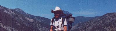
Rob (the author) and the Indian Creek Drainage
Llamalot at the Middle Fork Salmon?
Mule Hill to Indian Creek to Middle Fork Salmon:
Hot Springs Galore in the Frank Church River of No Return Wilderness
August 1-10, 1997
by Rob Jones
OK, it's a corny prologue, but I suspect you already know something about the long fight to save the Frank Church River of No Return Wilderness from logging, mining, extraordinaire commercialization, various sorts of plunder. I still have the infamous "2.3 million acres" poster published by the Idaho Conservation League approximately 20 years ago hanging on my living room wall. A comparison of the pristine area just beyond Mule Hill with the mine-devastated Stibnite area tells us what we have and what we have lost, for losing to development, like plutonium, is forever. This report is about a hike in the area we have, the Frank Church River of No Return Wilderness. We enjoyed the efforts and company of the hospitable harmonica-nosed llamas on this Middle Fork Salmon adventure.
|
Wild Vagabond Main |
Trip Report Index  |
Caveat  |
|---|
Day 1: Vulcanization: After pre-packing, we five hikers met at George's early Friday (George Cole, Paul Worth, Bruce Wickham, Maverick (Laurent Gaudreau), Garney Hardy, Steve Negler, and me). Alfie and Snowball, nose-musician llamas, accompanied us on this splendid venture. On to Arco, Challis, Stanley, on US 75 and onto dirt FS 579, Boundary Creek Rd, over Cape Horn Summit, past the turn-off to dangerous Dagger Falls, and on, we traveled. Then, we made a side trip, onto pavement(!), to Warm Lake and Stolle Meadow, where ˝ mile beyond the meadow we found the trailhead (TH) to Vulcan Hot Springs (HS). After putting the llamas Alfie and Snowball out to graze, we hiked the mile to Vulcan HS. It's very hot (perhaps 110 degrees F), and one could poach eggs in the vents just upstream of the man-made pool. Hot enough to vulcanize, and perhaps the first communal dip vulcanized the group some.
 |
|---|
|
Bruce at Vulcan Hot Spring |
Day 2: Kneeing to Kwiskwis: (Mule Hill to Kwiskwis Creek, 7 miles.) Today we entered the Frank Church Wilderness. But first, we finished the trip to the TH. We drove almost to the top of Monumental Pass and then off on a small track, searching for Mule Hill. After finding the TH, we packed and plunged down the meager trail toward Indian Creek. Clear rays of sun penetrated the old-growth firs. Small clearings dotted the landscape, burdened by a splash of sego lilies, gilias, lupines, etc.
Reportedly, it's a 4,000 feet descent to the Middle Fork Salmon, and over 2,000 feet of it is here, in the 3 miles from Mule Hill to Indian Creek. There are lots of deadfall obstacles to negotiate along the lightly used trail. Then, we found ourselves in Kiwah Meadow, alongside Indian Creek, where we rested and enjoying the near vistas of rugged country. And, we marveled at the lush, knee-high grasses and the pristine creek flowing through deep pools lined with granite pebbles and trout.
The knees had taken a beating on the downhill. We creaked on to Kwiskwis, camping where Kwiskwis Cr. meets Indian Cr. Bruce found the HS. It was over the hill and we were tired.
Day 3: Llamas, Tomahawks, and Bears, Oh My! (Kwiskwis to Tomahawk Creek, 3 miles + day hike.) I am writing as the sunset glints pink off the passing cumulus. Happy hour has arrived and we are not where we expected to be.
We visited the tiny Kwiskwis HS at the start of the day's hike. The hot water rolls for 100 or more vertical feet over the football-sized granitic boulders (of the 200 feet from trail to pool side at creek level) and into Indian Creek. The pool water is hot, and we splashed water into it before entering. It's a cozy two-person pool. Ahh, and the setting is superb. One can reach out and touch the cool waters of Indian Creek while gazing down or up canyon at the pristine wilderness enveloping Indian Creek.
 |
|---|
|
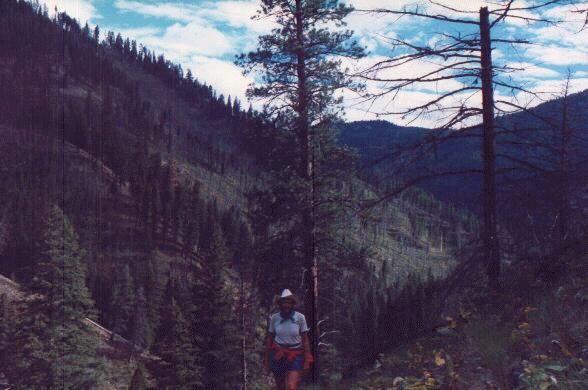
Middle Fork of Indian Creek Drainage |
The llamas arrived, without packs, but with bruised feet. So, we lounged by the creek, hoping Maverick would return. Bruce went looking for him, without success. Instead, Bruce cut his leg on a rock while clearing trail for the llamas. It was a deep cut and required butterfly closures. I later went searching for Maverick, and saw a black bear instead, oh my! A wonderful symbol and citizen of the wilds, the bear's loose skin sloshed hoops around his body as he rumbled down hill. I suspect he was feeding on the plentiful berries; service berries, huckleberries, wild raspberries, old thimble berries, and a few currants and gooseberries. The great omnivore was harvesting this cornucopia, and we also sampled it.
Day 4: Mo-Witching For Maverick: (Tomahawk to Middle Fork Salmon, 11 miles.) I am hiding in the tent from the pounding rain. We (Steve, Paul, Maverick, & I) are camped at Mowitch Creek of Indian Creek, about two miles from where Indian Cr. meets the jade-green waters of the tumbling, restless M.F. Salmon. Steve is cooking half of one of our massive 8-person meals, rain water running into his boots.
The day began trying to coax the llamas beyond Tomahawk. No way, Alfie went on strike. The bruising effects of the prevalent talus fields had brutalized the llamas' foot pads. Much discussion ensued about options: break into two groups, one continuing to Phillips TH (as originally planned), the other returning to the Mule Hill TH and later picking-up the through group; all returning to Mule Hill; and, some going on to locate the maverick Maverick, then returning and joining the llama group on its way to the Mule Hill TH. The latter option was selected. The llama group would rest at Mohawk, then start back toward Mule Hill. The Maverick marauding group would continue down Indian Cr., in an effort to reel-in Maverick, and possibly day hike to Sunflower HS, then return toward Mule Hill, catching-up with the llama group at Kiwah Meadows. We talked about others, but the one option for the llamas seemed to be returning to Mule Hill, and slowly.
As noted, Steve, Paul, and I continued toward the M.F. Salmon with full packs. Bruce came along with a day pack in the event that Maverick might wish to return to the llama group today and would need assistance on this long return. But, no Maverick as we dropped into the Indian Cr., proper. Winding along the trail beneath the stately ponderosa, past mountain mahogany, bits of bitter brush and sage, giant firs, flowers and more flowers, we relished in the Frank Church.
Slogging through the shoulder-high grasses, raspberry bushes, and occasional thistles (ouch!), the trail drops off the side-hill and heads toward the first ford of Indian Cr. The water is swift and the bottom slippery. No Maverick. On we went to the second ford, passing what came to be known as the "Maverick Camp" and finding a note promising "went to 2nd ford" signed, "Maverick." The second ford arrived as we turned to the south, passing the Middle Fork of Indian Creek, and as the canyon widened. Gazing downstream, we could feel the magnetic pull of the M.F. Salmon, somewhere in those purple folds of mountains and hills. At the second ford, no Maverick. After a late lunch, Bruce headed back to Tomahawk. We remaining hikers established camp near Mowitch Cr. and continued our Mo-witching for Maverick. Where could he be?? Two crossings of side streams, and two major fords of Indian Cr., and no Maverick. But, he's around some where, or so announced his boot tracks amidst the plethora of elk, deer, coyote, and rare bear tracks.
The trail slid into a jungle of grasses, sometimes chest-high, then improved as we approached the pack bridge across Indian Creek where it joins the cruising, fidgety M.F. Salmon. No Maverick. Two-engine planes roared low overhead as we hiked toward, then alongside the airfield at the Indian Creek Ranger Station. It started to rain as we searched the forest service buildings for someone who might know about Maverick. Maverick was with Ranger Rick (Piva), and he was happy to see us. Our flattening feet were happy, too. We had completed part of our long-range quest to the glorious Middle Fork Salmon.
As planes labored off the dirt strip, contaminating the quiet air with noise pollution, we asked Ranger Rick to contact our shuttle driver and call off the shuttle. It had been very quiet, up to the point the planes thundered and I peeked over the bank at the campground near the ranger station. Yikes. A giant J-boat was there, ferrying tons of equipment. A small city was developing as outfitters lined up two long rows of tables for dinner, covered with a massive tarp. Two perfectly coifed dudes lounged at the top of the boat-slide, discussing stock options and what might be on the menu someone else would prepare. It's a separate reality, as a cosmic writer has observed, stretching the concept of this "wild and scenic river corridor." Either that, or the circus has come to town. Because the water level has dropped, many M.F. trips are starting from the Indian Cr. site, and the straining planes were discharging passengers. As the rain began, Maverick began the return hike to camp, while I lingered and discussed volunteering at the ranger station next summer with Ranger Rick. What a fascinating place to invest in the future of our public lands!
Back toward Mowitch camp we hiked, this time fording Indian Cr. (rather than the pack bridge route) and saving a mile of travel. Squishing through the jungle, we noticed the glut of wild berries....then, a bear, adding punctuation to our return to the wilderness.
Day 5: Not the real Middle Fork: (Mowitch to Middle Fork of Indian Creek, + day excursion to M.F. Indian Cr. H.S., 2 + 4 = 6 miles.) It rained much of the night. As the clouds lifted, revealing the ghost tree-studded and deceptively steep slopes of the Salmon River Mountains, we were wading through the wet jungle along the creek. We camped at the Maverick Camp between the upper fords of Indian Creek. After a civilized lunch by a fire, we forded (again) Indian Cr. and thrashed up a seemingly trailless and narrow canyon until we found the abandoned trail high above the M.F. Indian Cr. Two miles up the canyon, we found the HS. It appears rarely visited, and although the water is hot as it rolls into the creek, little pool-building has occurred. Only a few butt-size poolets existed. After some construction and exploration, we returned to Maverick Camp and enjoyed some clothes-drying warmth. Although it had been a day of high humidity, brief showers, and warm temperatures, the fire felt good. Now, we are headed back toward Mule Hill, expecting to link with the rom-domma-llama group.
Day 6: By George (Ph.F.M.): (Middle Fork Indian Cr. to Tomahawk Cr., 5 miles.) It's early afternoon at the Tomahawk Cr. Camp and we have just finished another civilized lunch #2 of soup, followed by peanut butter cheesecake.
Today we walked from the Middle Fork Indian Creek to Tomahawk Creek (see Day 3). There, we found bags of presents and a note hanging from a bear tree. The note talked about gangrene in Bruce's leg and surgery on Garney's toe. The llamas? No report yet. The note was signed by "George, Ph.F.M."
Steve is regaling us with stories about international travel - to places where clans still practice cannibalism and slavery and other events. His story about Muggs Stump (a real person, I recall reading the obituary in the SL Tribune), Missy the Jewish Princess, and a crew of partially-prepared mountaineers climbing Aconcagua (in Argentina, and over 23,000 feet) was especially interesting, and not unlike the tragedy on Everest last year (except no one died on Aconcagua, but some probably should have). This group certainly could have used a philosopher of field medicine such as By George....
 |
|---|
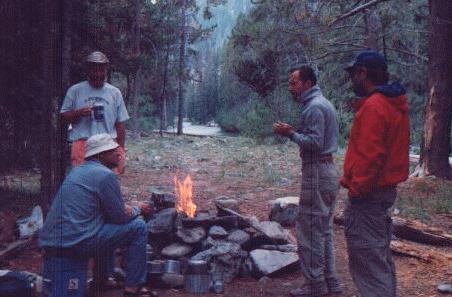
| George at Kiwah Meadows |
Then, on to two more fords of Indian Cr. before reaching the Little Indian Cr. crossing - cold water here. A tenacious tick, my sixth parasitic passenger this trip, hung on through the fords before being noticed. After gorp #2, we continued into the heat of the day, rolling the contours through side drainages and admiring the velvet verdant slopes across the canyons in the avalanche paths, and the pure tumbling waters of Indian Cr.
Now, it is nearly sunset and we are in central Kiwah Meadows. The llamas are munching the lush grasses of Kiwah while we sip the last of after-dinner drinks. The nearby banks of Indian Cr. Are decorated with the magentas, alabasters, and ambers of early summer flowers. It's heaven, or just a step away from it. It is good to have the group together.
Day 8: Muley Yellow Whine: (Kiwah to Mule Hill TH, 3 miles.) The dew was leaking into my boots as the morning sun turned the wet to steam along the glistening bank of Indian Creek. It was time to partially dry the tents, pack, and trudge up to Mule Hill TH. We felt like pack mules as we hiked the 2,000 feet from the meadows to the TH. Ribs of purple mountains arched across the developing panorama along the hike.
We waited at the TH from early afternoon to early evening for Paul, Garney, and Steve to complete their unproductive search for HS along Indian Cr. above the meadows. Then, the slow-twister road along the East Fork South Fork Salmon to Yellow Pine, past the terrorization of the Stibnite Mine - a horror in the daylight. In Yellow Pine, we heard the "mayor" whining about "those pointy-headed environmentalists" and how they wanted to lock up public land from the benevolent miners, loggers, and other welfare interests. Welfare is somehow bad for single mothers with kids, but generously OK for corporations and public land rapists. We obtained a few gallons of $2/gallon gas from the steadily talking mayor, and then, after changing a flat on the Suburban, we walked the dirt strip to the Yellow Pine Cafe for burritos and beer. The hot draw for this Friday night was a video of the international harmonica contest held last week in Yellow Pine. Yahoo. We considered entering the llamas in this contest, for they can harmonica with the best. We drove a mile or so down the Johnson Cr. Rd. and found a campsite near the Pioneer Cemetery, just outside the official forest service campsite.
 |
|---|
| Campfire at Bear Valley HS |
We hiked downstream along Bear Valley Creek, a stream large enough to be a river in most states. Fording this large creek was a bit tricky because it was wide, and swift, and there were many rounded rocks on the slippery stream bottom. The trail through this lovely stretch of the Frank Church winds peacefully through Lodgepole Pine, bumping through side-streams. After 3+ miles, we encountered the "HS" mark cut into a tree and followed the short primitive trail to the steaming whitewashed rocks of the springs. Below, and tiered down to the creek, five terraced pools, replete with clear water and sandy bottoms. Wow, super deluxe! On George's HS rating system, including water clarity, size/depth of pools, odor, scenery, temperature, seclusion, traffic, and camping, this gem necklace of pools rates a 9+++ with us.
Camped on a bar wedged between the HS inlet and the rolling rivulet, we soaked for a couple of hours prior to dinner. Then, post dinner, we soaked until the stars arrived.
Day 10: Snowful Departure: (Bear Valley Creek to I.F., 3˝ miles hiking, many miles driving.) It was trying to rain when we got up. I almost tripped over Alfie, who was lounging in front of the tent. Would a horse or even a dog be so peaceful? The skies spit some as we hurriedly rolled up the tent. Ah, and again, the HS. We enjoyed a thin drizzle from the comfort of the lower gem of the string of pearls. This hike would earn the proposed name "hot springs galore" if we had visited only this HS.
After more lounging in the crystal waters alongside the bubbling Bear Valley Creek, we headed back to the TH. Some of us tried the route along the side hill that avoids the creek ford. Not recommended. We thrashed through brush and inched across steep slopes before mushing through a soggy swamp/meadow on this non-trail route. After passing through the CG, we didn't go far enough up the dirt entrance road (to a bridge) and ended up fording a cold tributary to Bear Valley Creek in the drizzling rain. Bruce tried a running hop, then jump of the tributary, but the continuing drizzle had wet everything, his foot found poor footing, and he splatted against the far bank, partly in the water. After this example, the rest of us put on our sandals and walked through the stream, arriving at the TH about the same time as the llama group.
After getting all the sodden gear into the suburban, we continued down the dirt road to the highway, and through the rain to Stanley, and then Mackay. The clouds broke a bit and we saw new snow on Mt. Borah, Leatherman, and Mt. Mackay. We galloped through a driving rain from the suburban into Amy Lou's Steak House and Lounge for a gorging (yes, this used to be the infamous Frank's Steakhouse), then we friends of the IAC ended the adventure in I.F. There's a pile of equipment to dry and inspect before the next glorious adventure in the country of the roiling, rolling, raucous, ribald Middle Fork Salmon of the Frank Church River of No Return Wilderness. Contrary to what some of the corporate religious in Smog Lake say, the Frank Church IS THE Place.
|
Wild Vagabond Main |
Trip Report Index |
Caveat |
|---|