|
|
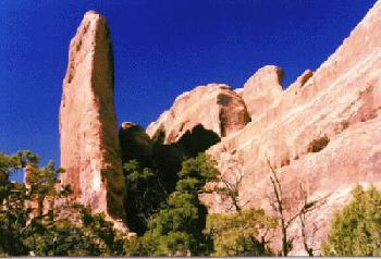
The Needles District is one of the districts of Canyonlands National Park, near Moab, Utah. The three districts are separated by the Green and Colorado Rivers. Island in the Sky District is to the north, between the Green and Colorado Rivers. The Maze District is to the west of the rivers. The Needles District is to the east of the rivers. See The South Arm of The Maze trip report for a general description of the area. This trip report is about dayhiking to the Confluence, running the Moab half Marathon, and hiking the Five-fingers loop in the Needles District.
|
Wild Vagabond Main |
Trip Report Index  |
Caveat  |
|---|
Day 1: Vertigo Drive to Moab: Lori and The Great Sinclair arrived in time to go to the Second Avenue Market & Cafe for lunch. Then over to REI for the customary gawk and shop before getting on the road. Another Alpine Start. Headed for Moab, we saw elk and deer galore on Soldier Summit Pass. A low-level speed, coffee, break in Price, then back on the road again. A blizzard jumped us as we neared Crescent Junction. Vertigo slosh into Moab, where we crashed at the Rustic Inn. Though we had initially planned on camping somewhere near Squaw Flat in the Needles District, the snow and late hour persuaded us to opt for Moab. The storm would layer approx. 3" of snow by morning. It's great to break free of the gravitational pull of the center of the earth near temple square.
Day 2: Confluence Cruise: Up, then down, the slush-infested road toward the Needles District of Canyonlands. Pausing at the rest stop near the Hole in the Rock tourist trap, the snow began to fly as we cranked the stove up - we cooked omelettes with green pepper, bean sprouts, cheese, mushrooms, and basil in the manmade cement alcove of the women's restroom. Traditionally Smegmatic. There were drying roads as we proceeded South - it looks as though the snow never extended this far. Into the Needles District - around 85 miles from Moab to the Ranger Station.
We missed the ranger. Off on a lunch break. Though we wanted to get info on Dark Canyon, one of our options for hike destination, we also intended to hike to the Confluence. Out to the Big Spring Can. trailhead (TH) we drove, threw packs together and headed for the Confluence. It's a 10.2 miles round trip. March! We wanted to return and catch the ranger before closing time at 4:30p. It's great to be back in The Country again. Warm, but not quite warm enough for shorts. There were occasional bursts of blustery weather to spice up the afternoon. We enjoyed a gorp break at the Confluence (of the Green and the Colorado Rivers), drinking in the spacious vista. Looking carefully, we located diving board rock across the gulch. It was this week last year that we discovered, and crept out near the diving board in The Maze District. And how much hotter it was this week last year, probably some 80s. Looking back to the West, we noted that what we've been calling Mollie's Nipple for years is actually Lavendar 2, and sits on a ridge near the lower portions of Lavendar and Davis Canyons - not far from the access road to the Needles R.S.
Being on a Blitzkrieg hike, we prompted ourselves to get back on the trail and wind up the torque for the return to the R.S. We drove up in front of the R.S. trailer at 4:29, but no ranger. So we hunted the crew down at the residence area and asked about Dark Canyon. Probably a great deal of water, and limited access except to the Indian Pass trailhead - which is not far from the confluence of Dark Canyon and the Powell sewage lagoon. Where else? How about a tour of the Needles backcountry? We'd consider it. For now, we were getting hungry, and it's time to prepare for the Moab road race. Back to Moab, where we attempted to locate le Jaques de la Rock, Paul (Post Mortem) Miller, and Nancy Sue Fagley. No Miller, so we showered and tried to find a place to eat. Every establishment seemed to be full of famished runners - around 1,000 were expected for the road runs tomorrow. We eventually managed to order some meatless spaghetti for delivery to our motel room. As we were in the depths of the Sinclair Stuff, packing equipment for the hike, and for exit from the room in the morning, our spaghetti, then Paul and Nancy arrived. Great! Catch-up talk amidst a medium gorging, plan race strategy, then off to bed. Visions of Confluence Cruises and road runs jogged in our heads.
Day 3: Moab Half Marathon: Out early - a quest for pre-race pancakes before 7 A. We found great home style flappers at the Canyon Cafe. No Miller, as le Jaques was reclining in his gaudy red-hued room at the Landmark Inn slurping yogurt. American bordello-style decor. After breakfast, we joined Miller before heading over to the school where buses to the starting line were loading runners. We wandered around - too cold to hurry to the starting line; but if we waited too long, it would be a cramped ride. Besides, there was no guarantee that there would be room on the last buses to depart. Lori & Jim were off to the 5-mile line, while Miller & I boarded the yellow caravan to the 13+ mile destination.
Cold and windy, we tottered and huddled in the lee of a phalanx of turquoise outhouses like a gaggle of penguins at 80 below. An hour to go to race start. What to wear? At the last minute, we stuffed most of our extra clothing in transport bags and plowed into the warm middle of the crowd. Just at race start, the sun broke out and the wind faded - deluxe! And God did smile. We had definitely arrived.
What a cruise down the Colorado - huge walls hovering and looming above. And what lycra on fantastic female forms! Wow. Miller said it was polypro, but I know my lycra. Level pace running with the jock of the rock - within 5 seconds a mile pace for the first 8 miles: about 7:10/mile. Level terrain, grand views all around and above - a premier event. We discussed dropping or increasing the pace after 8, but opted to slightly decrease the torque, finishing in 1:37 or approx. 7:20/mile. Not bad for an old, gradual student beset by excessive academic oppression, preliminary exams phobia, and mediocre training and social involvement. A testimonial to the power of Smegma.
Lots of fruit and drink at the finish - we had passed all the water stations on the run without effect. Then a quick shower at the Miller/Fagley bordello-glow room (there were red back lights around the head moldings, and heavy red drapes and carpet) before a lunch stop at the Golden Stake and ice cream to top the rehabilitation efforts.
Saying farewell to Paul & Nancy, we headed South, detouring to the grand town of La Sal - Lori had forgot to call her mom, and this was the only operating phone until Blanding. Past the "Mega Shaft" - where the sign said something about `heavy metals' - an ominous tone. Yes, give owners of public land the grand mega shaft, all brought to you courtesy of the BLM (Bureau of Leasing and Mining). Finally to Squaw Flat C.G. in the Needles District of Canyonlands. Campground full. So we put on our faces of fine and brave humility and asked two lovers from Colorado if we could share their camp spot. "OK" they said after a brief discussion. An overnight low of 24.
Day 4: Peekaboo Snow Romp: It was cloudy and there was a raw bite to the wind as we packed up for the start of the hike. After a second discussion of possible routes with ranger Jim McChristensen, we decided to forego Dark Canyon, etc. and do a loop through the "fingers": Squaw Flat ---> Peekaboo Spring ---> up Salt Cr. (3rd canyon o the right = "5 fingers") ---> plateau ---> Butler or Chesler Canyon ---> return via Chesler park ---> Squaw Flat.
We began by sitting in the car at the trailhead, nibbling a 1:00 lunch and waiting for a vigorous snow storm to lift. Eventually, we donned anoraks and packs and headed for Peekaboo Spring. It continued to snow over much of the 5.1 miles to the overlook of Salt Cr. It's a beautiful, undulating route through Lost Canyon and other side drainages - the ranger had appropriately called it "one of the most picturesque routes in the park". A few fixed ladders assisted us on the soggy route. Near 5p, with platter-size flakes falling, we crept under an overhanging rock and set up camp - just above the route down into Salt Creek. Curried tuna shells for dinner. Yum. 3" of snow and 30 degrees. Overall, a delightful and quite pleasant day.
Day 5: Picto City: Sun! What contrasts - with the white snow accenting the red sandstone. The white teeth of the La Sals are gnawing at the azure sky. Red, white, and blue - a very patriotic morning. Closer and closer to the center of the earth. On the trail starting at our front doorstep, and before long we encountered a few small ruins tucked away under narrow overhangs. Barrier Canyon style? More likely Anasazi, we decided. Further down, it was necessary to creep down a 30' crack on a pipe ladder. Then, on the creek level and over to the ORV defilement along the totems separating the oxbow loop of Salt Creek. Great pictographs near the hole-arch in the totem ridge. White Anasazi turtles and hand prints layered over the faded red trapezoidal figures of the Barrier Canyon Culture (3 - 7,000 years old, while the Anasazi are more like 700 - 1000 years old).
We made many crossings of Salt Cr. as we proceeded upstream along, sometimes parallel to, the jeep road, which was on its way to the All American Man, Angel Arch, and other grand sights. Bridge-building, throwing stepping stones into the creek, though there had been an obvious drop in water level since last night (4" deep X 9' wide). The next major sweep to the left and we were cutting the corner when I saw what seemed to be a reddish pattern peeking above the tops of a clump of junipers. A little closer - yes, an obscure and deluxe picto panel. Apparently, almost no one visits this extraordinary panel, as we could see no tracks in the cryptogamic soil, and no evidence of visitation below the panel. Barrier Canyon style - and lots of figures. Men, spirits, sheep, snakes, et al.
The third major canyon on the right, and we turned up a small tributary toward the trail less five-fingers area. Up canyon, then turn left at the next major junction after passing a minor inlet which joins not far after leaving Salt Cr. Water flowing where we camped along the narrow trail under an overhang. Later, we walked up on a small rise to a virgin park - replete with lush, ebony cryptos and dotted with ash-gray tuffets of grass. Only an occasional deer footprint disrupted the pattern. We didn't encounter anyone today, though we did hear the bellicose interruption of an ORV along Salt Cr. early in the morning. The temperature would drop to 34 tonight. Lots of clothing was needed to ward off wind chill after sunset.
Day 6: Horned Out: It was a sunny morning, but accompanied by a cool breeze. Malt-o-meal refueling and then further up the 5-fingers. 5-fingers, because the tributaries on this side of the plateau have a characteristic hand shape with fingers. Almost exclusively right forks. Pictos, looking like a sunrise ---> sunset theme, on the North-facing wall near the first South-traveling arm after camp. There it is, on the point of the South face of the next junction - three trapezoid figures watching over the wild canyons. A wrong turn, as we turned right and thrashed up a horn-shaped arm until walled out by an abrupt headwall. It's a great canyon, however, since it contained two high arches and striking sandstone walls.
We hiked back down, then up the main canyon. We gathered `bloater bags' of water since the flow had slowed to a trickle, then ceased. Once reasonable packs now created fallen arches and decreased stature. Past the Starvation Pocket arm, and higher toward the headwaters. We grunted and scraped the final half mile or so, until we found ourselves in the throne bowl below the plateau. There are snow-covered 800' walls all around. It's sunset and cooling rapidly, so we hurriedly threw camp into place. Low 30s by bedtime, with an overnight low of 27. There was a good deal of ice in the water bags in the morning.
Day 7: The North Face: A winter-like scramble to "Butler Plateau" (our name). My altimeter had gained 120' overnight. High pressure? Good news. It would be a 3.5 hr. excursion, often in 1-4" of snow, up the obvious route. This "obvious route" proceeds up the left bowl when looking at the wall from the stream bed. Cold and wet feet. We needed the webbing two times; snow scramble, then belay others and packs up. Into the afternoon, and much warmer on top as we determined how to locate the route from the top ---> down (where we came up): by sighting between the high point knob on the plateau (remnant of a Chocolate Drop formation) to Lavendar 2 (once called Mollie's Nipple) takes you right to the top of the obvious route. Loose, soft, untrammeled soil - like that near The Plug in The Maze. The conical high point is 30' above the general level of the plateau, and rises to 6400'. 3 P. and lunchtime in the lee of the high point, even allowing a brief lizard-bake in the delightful sunshine. Up on top, we found two sets of deer antlers, one attached to a partial skull. Great vistas: over to The Land of Standing Rocks, Abajos & La Sals, North to Junction Butte & Candlestick Spire. Big country. There is no obvious route down into Chesler Can. upon a brief inspection, though we were fortunate enough to find two potholes - which we sucked nearly dry with Sinclair's water filter. We camped in the lee of a small swale along the South edge of our private partial mile plateau, suspended far above the rest of Canyonlands. Another day without seeing anyone. With an overnight low of 20, we would awake to frozen walrus bags and water bottles.
Day 8: The Obvious Route: Butler plateau, down Chesler Canyon, through Virginia Park. It was 24 degrees when we got up. Glorious morning, delightful views. We smacked on couscous with Jerome peaches and blueberries for breakfast while we anticipated the solar load taking full effect. We packed and hauled the behemoths the short distance to the edge of the plateau, then scouted around for a route off the high desert and into Chesler Canyon - far below. An obvious route trough the grabbens and sandstone ghouls? Look, look, search, attempt a route only to be ridged-out. Lots of rock bands to negotiate. It would be 11 A. before we started down the obvious route. "Obvious Route": a fine name for a new and unique line of women's lingerie. Made from three or four of the finest threads of silk, platinum, etc. The obvious route. Also known as ORC (have you seen your orc today? Obvious Route Clothing, it adorns only the most discriminating and daring).
There was snow in the top portion of the obvious route - a vertical notch - apparently a "break" or fault through the layers of sandstone. The location for this obvious route is: Just to the right of the three standing goblin spires when seen from below. A slow and sometimes precarious (largely because of the snow) route down the 600' face. The trail from the head of Chesler Can. vaguely begins/ends here. We enjoyed a gorp break, after seeing our first hikers since Peekaboo Spring.
Then, down the sandy wash of Chesler Canyon, stopping just before the vestige of jeep track trammeling in along the drainage - to look for Virginia Park. Off course, we hiked through a side canyon (and out into the "real route") - filled with brush and assorted green grabbers. A precarious gripper move here, but better than retracing our steps along the pseudo-route. Up a slickrock plumbing avenue. When it rains, it's just like flushing a toilet, we imagine.
Virginia Park: a level above the drainage. Bounded by sandstone sentries, carpeted by a luxurious layer of crytpos. Small and precious - no bovine activity here, and a limited number of trails. With sunset approaching, we returned to Chesler Canyon and continued downstream. We passed a huge cairn. Fixating on the cairn, we never thought to look for the trail - since we expected that the cairn marked a route from a nearby drainage. Stumbling along, the footprints became less frequent, then faded to a set of two. Obviously, we had missed our turnoff. 6:30, so we located a passable site and threw camp into place. Start high, sleep low (or something like that). A headlamp camp, though our night vision was enough to establish the majority of camp. Chicken, clam, etc. paella (which refers to "the pan", not the menu item). Interesting and picturesque spires and muffins have surrounded us most of the day. 40 at bedtime, but clear and calm.
It seemed like 20 minutes, but 3 hours later I was blasted awake by an incredible gust of wind that I would estimate at 65+ mph. I had a difficult time getting up and out to anchor things again - since I had my arm out the door holding onto the fly. Then a horizontal rain, suddenly turning to snow. Thrashing about in the wind driven snow, I found huge rocks with which to anchor the fly and tent. An hour after it started, the storm jumped out of Canyonlands. Later we would learn that the wind blew the door off the ranger's trailer (and off into the junipers). 29 degree low.
Day 9: Have a joint: (Chesler Park/Joint Trail) It's sunny and calm, and only the snow and partially frozen water bags remained as evidence of the previous night's demon storm. Yes, we were only 1/4 mile from where the trail crosses Chesler Canyon. Up we went toward the Pinnacles, missing (or rather ignoring) the route which cuts off directly to the Joint Trail - it appears to be an old route which is revegetating. Along the Pinnacles, we ditched our packs and readied ourselves for a tour of Chesler Park and the Joint Trail. Deluxe! The Joint Trail is a deep, narrow sandstone slot that connects the canyon with Chesler Park. It is narrow enough in spots to require sliding packs through separately. Out the other side of the Joint - and what do we see just across Chesler Can., but the giant cairn and beyond it, a pair of toilets at the (now) end of the jeep rut. Amazing, for we had passed within a hundred yards of all this civilization without realizing it. Looping back through Chesler, we walked through our Christmas camp (of '83) near the drop into Elephant Can. Still blustery.
We collected our packs and, hiked through the gap before the trail crossing of Elephant Canyon (where we bloated the walrus bags from a small gorgeous pool in the turquoise Elephant Canyon Shale). Then through a mini-joint and out to the junction where one trail goes North to the base of Elephant Hill, and the other, which we would follow tomorrow, continues W/NW to Squaw Flat C.G. (3.5 mile venture from this intersection). We were awed by glimpses of a tremendous radiant sunset through the building clouds. Our tent was squeezed between brush and shaggy juniper, with a cactus pad doormat. Kitchen area on slickrock - no crypto bashing here. Just right. An overnight low of 24 - good thing we had kept some water in the tent and hung the bloater bags in the tree to reduce radiation of heat.
Day 10: Out, out, and slide: Trail junction to Squaw Flat to Moab to Soldier Summit to the center of the earth. Cloudy, cool, but a generally nice morning. Lightly-gloved hands firmly wrapped around fair-share cups of hot tea between bites of wheat germ cereal. On our way, a slow trip out. Any excuse to delay: a fantastic photo, a chip of brownish jasper, change into shorts - back into pants. Completing the loop, with only a few hundred yards of duplicate route (not counting our wanderings on the plateau, etc.). We encountered a far different scene from when we left amidst the snowstorm. Plop the packs in the car, 1 p., and head for the R.S., where we stopped briefly before the 85 mile drive to Moab. It's too fast traveling in a car, it seems like 45 is warp factor 4. Deciding it was time to change the two quarts of oil in our hair (the cold weather had dampened out enthusiasm for daily baths), we stopped at the KOA about a mile South of Moab for a $3 shower. Ahh.
Then into Moab, crown jewel of S. Utah, and the batatakin shop (Trading Post) for two pairs of Navajo earrings. The Dos Amigos II restaurant (56 East 3rd S) would not open until 5, so we continued to the Dos Amigos in Price (19 South Carbon Ave.). Great food, chicken enchiladas rancheras, etc. On again, a smothering snowstorm flew in as we went up the flank of Soldier Summit. There were big pileups near SLC, as parts of the roadway were layered with black ice. Bumper cars on the overpasses. Late arrival at the center of the earth - but not too late to enjoy and reminisce over slides from the Boulder/White Clouds extravaganza, where we had been hot tubbing in the dilapidated bathtub at Bowery Hot Springs. 2 A. and time for bed.
Lori & Jim caught the 9 A. flight out - haven't we said these same long goodbyes before? Too soon. The radio reported that high pressure was creeping back in, after a week of storms and gloom in SLC. Just in time for the return to work. The decay of memory has already begun, and retrieval cues will need to repeatedly rehearsed to obviate collapsing the Needles District tour into a millisecond of recall. Good thing I have this trip report.
It's two weeks later, and the sun blisters on the backs of my hands have all but disappeared, but my fingerprints - ground off on the slickrock - are still regenerating. Signs of good times. ;-)
|
Wild Vagabond Main |
Trip Report Index |
Caveat |
|---|