(Click the image for a full-size view (20k); Photo by Rob)
|
|
|---|
|
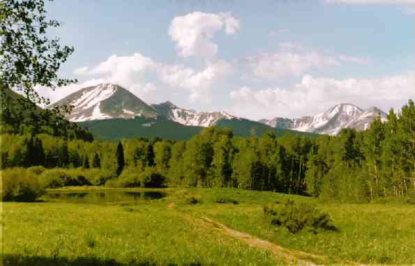
The LaSal Mountains and Warner Lake
(Click the image for a full-size view (20k); Photo by Rob) |
Prologue: The towering La Sal Mountains are the second highest range in Utah, the tallest being the Uintas. They loom over the canyon country and Moab, and are directly east of Moab. The highest peak is Mt. Peale at 12,721'. Twelve of the peaks top 12,000'. The La Sals are laccoliths, a term which comes from the Greek words cistern and stone. Magma rose under sedimentary layers, intruding into sandstone and shale layers, but did not break the surface as in a volcanic eruption (some oozing apparently occurred, however). Successive intrusions developed overlapping laccolithic blisters. The intrusions lifted the overlying sediments as much as 6,000'. There is an abrupt transition between the mountains and the desert lowlands. It's an interesting place for wanderers with geologic interest and all curious hikers.
See Canyon Country's La Sal Mountains: Hiking and Nature Handbook by Jose' Knighton (Canyon Country Publications, Moab, Utah) for trail and more geologic and natural info. There is a well-designed Hiker's & Skier's Map of the La Sal Mountains, also published by Canyon Country Pub., that links the Knighton routes, by number, to the ground (map).
Day 1: Fry pan to refrigerator: The magenta glow on Haystack Mountain has faded as I write notes, wearing hat, pants, & coat. What a contrast to the trip to the La Sals, across the San Rafael Desert. The drive was warm, approaching hot.
I found a site at the small Warner CG (at 9300'),
then walked part of the trans-mountain trail just outside the CG. I had
briefly considered this trans-La Sal route for an Idaho Alpine Club venture,
but withheld judgement because the route is not among the big peaks. However,
it looks like it would be a good, but brief, trip.

|
|---|
|
View South from the summit of Manns Peak
(Click the image for a full-size view (20k); Photo by Rob) |
Day 2: Lactic La Sal Laccoliths: I was up early and hiking to Jackass Pass from Warner Lake. It was quiet, and frost glistened on the yarrow in the shadows. It's a lung-burner approach, during which one gains nearly 3,000'. Four miles to the pass, then up Pilot Mountain (12,200') for the first gorp stop. Hiking the vertical ecological zones, the wildflower display had changed from the ostentatious such as mules ears and blue bells to the subtle phlox, old man of the mountains, and gentians of the high country. It's wonderful tundra-like terrain, cluttered with lots of talus. Fractured igneous rocks are occasionally intermingled with sandstones and shales. Wishing I knew a bit more about geology, I turned my attention to a goshawk rocketing by, screaming full-speed into the dense spruce stand down slope.
Shuffling down from Pilot Mountain, I hiked over Dry Fork Peak (11,849') along the way to Manns Peak (12,272', 5th highest in the range) for gorp #2. Here, I encountered the only hikers I would see all day, two hikers who had climbed Manns from Burro Pass. There must be some iron in the rocks because my compass sightings are all off by about 5-10 degrees, although they were right-on at Warner Lake. I was enjoying the views and determining a route to Burro Pass, and finally a return loop to camp. This would have amounted to about 7 miles of trail and an unknown mileage along the peaks route.... But, there is the tempting summit of Mt. Tomasaki (12,239'), and it's probably less than a mile away, albeit farther from Warner Lk.
Tomasaki is not difficult to climb, but one must first lose much of the altitude before regaining the summit of this, one of the least-climbed peaks in the La Sals at (12,239', 7th highest in the range). I lounged quite awhile on Tomasaki, considering if I could return past Manns and hike Mill Creek Peak.
It continued sunny and windy as I skirted back around the slope of Manns, now feebly considering climbing Mill Creek Peak. After sprawling lethargically in the tawny alpine grass on the mid-slope of Manns, I knew it would be folly to tackle Mill Creek. So, I peeled off Manns and rolled down slope to Burro Pass, then looped back to Warner Lake, exhausted.
But, ahh, the water in the shower bag I had left
out on the table was very hot. I love that solar load, without the wrenching
heat, in the mountains. But, I had to recharge a bit, vacantly staring
at the mountains from my slouch in the lawn chair, before I could take
a shower. Life is tough. It had been a 12 mile (or so), 4 peak day with
lots of elevation gained and lost.
|
|---|
|
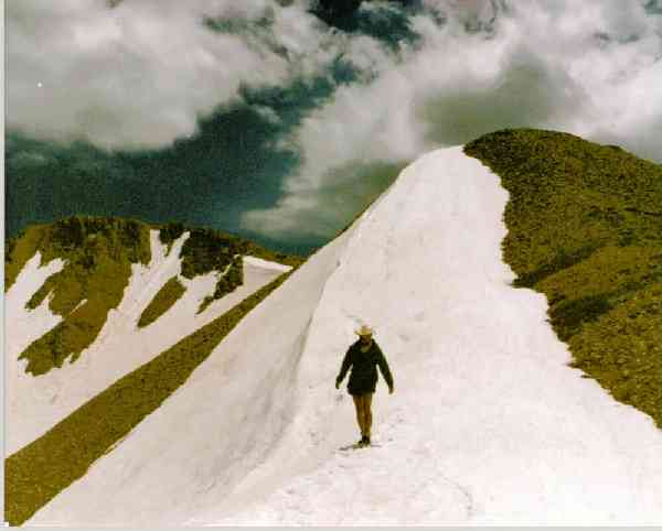
Descending Manns Peak
(Click the image for a full-size view (19k); Photo by Rob) |
Day 3: Mainly Mellenthin: I got up late (8 a.m.) And lounged for awhile - still recovering from yesterday's peak express. Two doe deer again visited camp, sniffing around like vagrant dogs. I noticed them as I was looking across a sliver of tiny Warner Lake, up at looming Haystack Mountain and the end of Burro Ridge.
After driving back down to the La Sal Mtn. Loop Road, I went over to near Geyser Pass, in the south section of the La Sals. To get to Mellenthin (12,645', 2nd highest in the range), one hikes up a scree-lined drainage, through a spruce forest, then on shifting talus to the summit ridge, completing the hike requires more talus tip-toeing to the top. There is no trail. It's just talus this and talus that, to the summit and some terrific vistas. As noted, only Mt. Peale, at 12,721', is higher among the La Sal peaks. Much of the 2,000 vertical feet (over 2 miles, one-way) from the TH is on tippy talus, so I postponed plans to hike Laurel Peak or the distant link to Peale or the hulking Tukuhnikivatz (12,482'). Besides, thunderheads were blossoming right above. Amazing. So, I retreated to camp and another glorious hot shower.
Day 4: Very Vegan; church in the spires: I am writing by light of an aromatic aspen wood fire. It's been a long day of frustrations and delights. I had planned a grand loop hike out of Miner's Basin, and early on a Sunday morning drove to the spot where I expected to find the access road. Where is the road? Consulting the map, I seemed to be in the right place. On-the-ground investigation revealed that some multiple-abuse miners had removed the signs and blocked the road with boulders. Good work, more of our public land successfully diverted to private carnage and corporate welfare (who pays for cleaning up toxic waste, closing/rehabilitating mining "progress?").
Determining that I could also get to the area by hiking out of the Warner Lake area, I returned to camp and started hiking up the trail to Gold Knob Pass. What a waste of time the morning had been. But now I was gaining altitude through a dense aspen stand, encountering more wild flowers and birds of all types. This is definitely the longer route, and it is redundant to some of the hiking I had already done.
I veered off at Gold Knob pass (leaving the trail) and hiked a rambling ridge-route through spruce, then over Mount Vegan (11,469'), before reaching Pilot Mountain (again, this time from the west ridge). Amidst gathering winds and blooming clouds, I considered not continuing along the twisted ridge to Green Mountain (12,163') and eventually to Mount Waas (12,331'; 4th highest). Humm, it didn't look too bad,... so I hiked to Green Mountain and paused for gorp #2 (#1 had been on Vegan) while further observing the weather patterns. Ok, so one drops several hundred feet to a saddle before climbing back to the summit of Waas, so the weather is uncertain, so it's time to go or abandon the venture.
I hiked to Waas, where the winds surprisingly subsided and the hoards of butterflies and ladybugs that are present on many high peaks appeared. The views are great, because Waas is the highest peak in the northern section of the La Sals. I could see bits of the Fisher Towers and the Colorado River far below and to the North. The cluster of big peaks (Mellenthin, Peale, Tukuhnikivatz) in the southern group nosed prominently along the south skyline. The furrows and bumpy ridges of the Canyonlands country rolled into the haze to the west. To the east, well this is part of Colorado that is rarely visited and appears to include sprawling ranches in old rincons or hanging canyons? Somewhere out there is a town called Paradox, CO. Perhaps that says it all. It's a good day to be in church.
I retraced my route, off Waas, over Green Mountain, over Pilot and Vegan, and back into the deep spruce forest. Yikes. I came across a steaming-fresh pile of bear scat and an accompanying footprint in the forest duff. The trees seemed more claustrophobic than a few moments before. Recovering from temporary vigilance, I thought it would be good to see one of these high-country omnivores, but I didn't. However, it's good to know they're about and it also says something about the wild character of the area. Stopping on the ridge beyond Mount Vegan, one gets the best view of Moab and vicinity (the view is generally blocked by lower peaks when you're on the high points). On Vegan, I found some "crystalline structure eggs" that seemed highly unusual to me, given the geology of the area. They seemed to be associated with breaks in the geology, perhaps via a vent or fracture line? Well, I don't have enough info to answer the somewhat obvious questions; and, besides we don't ask such "origin" questions when in church. Finishing the approximately 9 miles of hiking as I descended back into the relative darkness of the aspens below Gold Knob Pass, I was watching the sun rays filtering through the aspens when "whoom, awk!" a spruce grouse and juveniles exploded at my feet. Wake up, yoww! Regaining normal heart rhythm, I continued to camp, where I enjoyed the aspen fire you already heard about.
Day 5: Back to the burner: There is not much to report about today, except that I lounged watching the sunrise play across Haystack Mountain, packed leisurely, and explored a bit before driving home. The Trans La Sal Trail (24 miles) and the Triple Crown Connecting "Trail" (rambling high across the big southern peaks for 8 miles, shuttle required) would wait until another trip.
The La Sal Mountain Loop Road continues to the north from the Warner Lake turn-off, then drops into the rising heat from the desert -off the uplift, heading west through Castle Valley and along the Colorado River to meet Hwy 191 north of Moab. Along the way I saw a desert bighorn sheep sneaking a drink from the Colorado, and a ring-tailed cat scrambling to avoid river-runner shuttle drivers. The La Sals are a relatively small, public religious edifice that deserve and desire more exploration.
Please read and act upon the message in the caveat ..thanks.
|
Wild Vagabond Main |
Trip Report Index  |
Caveat  |
|---|