 |
| |
PROLOGUE: This is a description of a moderately long backpack in the Jarbidge Wilderness, in 1999. I am happy to report that this country was little discovered when I first visited it and still is. How far is this hike? Our estimated trail mileage was 59 miles, and the energy required miles (ERM) were about 76. The GPS point-to-point distance was 37 miles, for waypoints entered only at the major corners. ERM attempts to account for elevation changes and other stuff not easily represented on two-dimensional mediums, such as topo maps, by adding a mile for each 1000' gained or lost. See the 1988 Jarbidge Wilderness trip report for some background information about the Jarbidge. Please note that the Jarbidge is not a spectacular place like the Tetons, etc., and it's not easy to get there. But, once there, you're really out there. (Yahoo!) So, please recall: Wherever you go there you are! (Wherever You Go There You Are is the title of a book on meditation by Jon Kabat-Zinn, and particularly relevant to those more interested in stewardship of our public land rather than engaging in mechanized ecotrashing.)
Start your research, etc. with a visit to Friends of Nevada Wilderness.
I hope you write your first wilderness support letter as soon as you read this report about the Jarbidge, and, lots more later. It's important to support dispersed recreation, and to enable this, we need more officially designated and stewarded wilderness. Please do your part today.
Wild Vagabond Main  |
Trip Report Index  |
Caveat  |
|---|
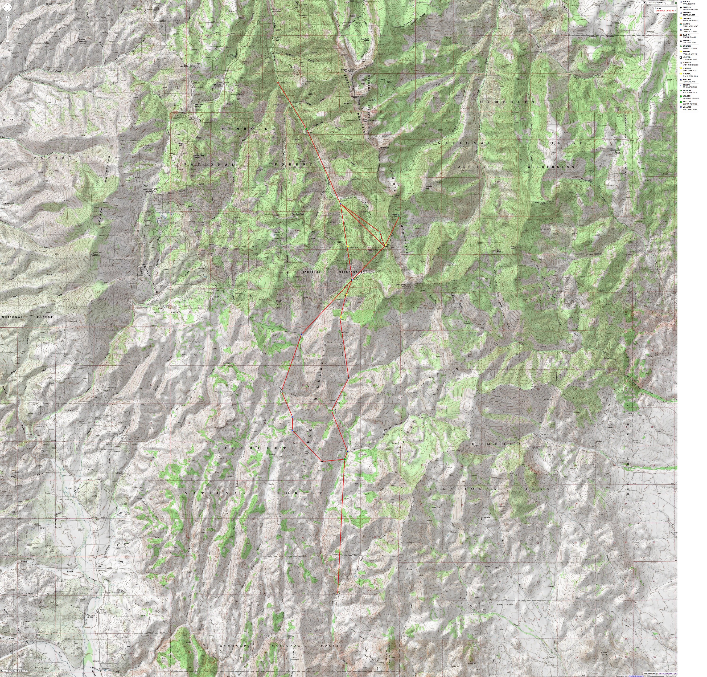
The map below was created from individual gps waypoints, forming a route (not a track). The route goes directly from point to point, not following any trails. It is provided here to give an overview of the area and present lots of trip possibilities.

| ||||
If you want to view a full-resolution map, click here. Caution - do not use this map or gps track for navigating the route.
DAY 1: RUMBLE TO THE TRAILHEAD & WILD NIRVANA:
(Idaho Falls to the traditional wilderness TH, approx. 230 vehicle
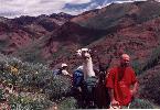
miles, 2 trail miles.) The sun has departed, and we (George Cole, Paul
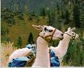
Worth, and I, along with the instrumental support unit, George's
harmonica-nosed llamas, Cicero, Snowball, and Alfie) are enjoying cocktail
time while watching the last golden glow on what we believe is Jumbo Peak
peeping through the notch between low hills studded with yellow on red
and black basalt spires. We are at the Jarbidge Wilderness boundary and
the traditional TH. A flood a few years back removed the road at the Pine
Creek CG and we waded and walked here, over river boulders where no road
existed. Hey, it's good to see
wild country expanding. A flood of memories engulf me as bits of long ago
Jarbidge adventures intrude into today. Mules Ears dot the foreground,
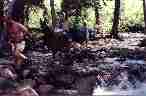
along with flowering Chokecherry bushes. We forded the Jarbidge River's
snow-melt water once, and it was nearly knee-deep.
The day started in Idaho Falls at 8 a.m., gathering
llamas and driving to Twin Falls for lunch, then on to Rogerson and Murphy
Hotsprings, Idaho before leaving the tarmac for the dusty winding road
leading across the state line into Nevada and southward to Jarbidge, the
town, by 5 p.m. We enjoyed the humor near the Idaho/Nevada line, including
20 mph and curve signs as we inched along the serpentine route adjacent
to the Jarbidge River. Jarbidge, the town, is arguably among the most remote
towns in the lower U.S., with access by fair weather roads (translation,
impassable when wet, and not open until late Spring) over Bear Summit,
and the only "good"
road a winding narrow dirt snake from Idaho.
The nearly full moon is peeping through the fluttering
leaves of Cottonwoods in the Jarbidge River notch. We're
at 6925' and we feel the anticipatory flow of wilderness nirvana.
DAY 2: PUSY MANIA: (to pass above
Jarbidge Pond (AKA, Lake), camp at 8200' along Jarbidge River, 8 miles,
10 ERM, energy required miles.) Cicero's
ears went forward, rotated quickly, and we both saw movement. I saw a jack-in-the-box
round head pop up within a Chokecherry bush at the edge of the Jarbidge
River. Cicero simultaneously barked an alarm call that sounded like a full-decibel
disco Chukar Partridge and ran across the brief flats of the historic trailhead.
I yelled and popped up off my perch on a llama pack box, spilling hot cocoa
on my pants, and headed for where the head had been. No noise. Nothing.
Wait, there's water splashed
on rocks on both sides of the river, silently, in the thick brush, by something.
Could it be the legendary Tsawhawbitts? We were about 20' away and eating
breakfast, yet the big pussycat lurked to within this distance. Cicero
barked more, but we heard only the rumble of the river and the distant
whisper of the morning breeze in the trees. George, Paul, and I investigated
for tracks and such, but we found only the confusing splash marks on the
rocks at river level. We saw indefinite big tracks, apparently without
toe nail marks, as we scanned the trail for Cougar tracks and scat during
our climb along the Jarbidge River.
I suspect there is a reason why they call the big
cirque on the other side of the range, Cougar Creek Cirque, headed by Cougar
Peak. The volunteer campground host had told us that a Cougar had harvested
(eaten) a big dog from a porch in the town of Jarbidge a few weeks ago.
Now, this is true multiple use, wildlife harvesting domestic animals.
With the frost melting off the llamas'
backs, we packed and headed up the Jarbidge River Canyon. After a wade
across the river and 2 plus miles of hiking, we came to the junction of
the Jarbidge River Trail and the route to Marys River. This is the now-gone
Perkin's Cabin junction, at 7675'.
Then, we headed up toward Jarbidge Lake, which we walked to, but not with
the llamas, who became snowbound near the level of the old cabin at the
Norman Mines. From near the cabin, it was a snow tromp. Paul and I managed
to trudge to the pass above mostly frozen Jarbidge Lake for a look around.
We noted a full-circle sun dog and some side dogs while at the pass, their
prism-splitting colors sparkling in the bright sun. We returned to where
George and the llamas were and then we all descended to the 8200' level
and camped along the Jarbidge River amidst the pick-up stick trees of old
snow barber avalanche activity, where we enjoyed some wine before dinner.
Thanks, Cicero. Then, the pile hat, jacket, and pants came out as the sun
set.
 |
DAY 3: MARY, MARY; PLAN B: (Jarbidge
cirque to West Fork Marys River, 6 miles, 8 ERM.) Cicero sunk to his knees
in the mushy tundra and his ears went back. Behind him Alfie hummed a higher
pitched than usual harmonica tune while Snowball, at the end of the llama
caravan, calmly surveyed the scene with a disdaining side glance and looked
like a Southern high-plains Wyoming hick chewing on a long grass stem drooping
from his elegant ultra-Roman nose. Here we are, off route, purposely, on
the North side of the pass into the West Fork Marys River, attempting to
pick a path around the remaining snow banks. Argh, would we get snowed
out again!? We didn't, and there
were no drifts on the South side of the pass. Hiking up a bump near the
pass, we viewed the worn shark teeth of the Jarbidge Mountains, lined along
the North-South Jarbidge cordillera.
We started the day by backtracking to the Perkin's
Cabin junction, then slogging up from 7675' at the junction to 8828' at
the pass, then descending to 8054' where the trail meets the West Marys
River and a 4-way junction. We came from the North, the trail goes to Jarbidge
Lake and pass to the NE from the West Marys River Junction, SW along West
Fork Marys to Camp Creek, and South to Marys River Basin. All of today
we hiked on the Jarbidge South quad map.
I'm comfortably
esconced in scattered Aspens in our camp just West of the trail junction,
watching the after-eight o'clock
indirect sunglow on the buckskin hills which are carpeted with army-green
sage and dotted with yellow Arrowleaf flowers. We've
enjoyed an early camp, wine with spaghetti, and fruit for dinner, and a
visit from long-rider Reed Tucker on an old horse and trailing a nervous,
big-hoofed, BLM mustang. Reporting that he is from Twin Falls, he sheepishly
admitted that he was once from Orem, Utah. I understand. When asked, I
report that I am from Idaho, although I have spent over a decade in population
bomb Utah. We would encounter Tuck's
trail over the next few days.
After hiking all day in shorts, we donned jackets
and pants as the sun left our bowl. The llamas are rolling in dirt as we
prepare to go to bed, and we're
thinking about the great views from the bump above Marys Pass, from which
we could see a lineage of Jarbidge peaks to the NE, Jarbidge, Jumbo, Square
Top, Matterhorn, and Cougar Peaks, and part of Marys River Peak to the
SE. All these peaks are over 10'000 feet, and from any good viewpoint,
one can see that the whole range floats on a sea of sage brush and the
squiggles of hot mirages.
Our plan A had been a varied loop through the head
of the East Fork Jarbidge, then out Camp Creek into Marys River Basin,
returning via the route we were now on. But, because of the snow, remaining
because of a late, wet Spring, we were improvising Plan B, and it is grand.
DAY 4: OH, WHERE IS MARY? (Off route
in the Jarbidge; West Fork Marys River via trail 019, to Camp Draw, to
Lost Draw via trail 197, along ridge trail 196, and down to Marys River
Basin via trail 093, meeting trail 018 at the river; estimated trail mileage
was 10 miles, ERM was 13; parts are little used, non-maintained trails.)
I had plopped down in the granulated porphyry to set a GPS waypoint (the
GPS, global positioning system, is my new toy), and there it was, a want-to-be
arrowhead, chipping marks wrinkling in its blood-red obsidian skin. Caressing
it like one of those yuppie worry stones, but with contemplation and awe
instead, I looked back up at the mostly-vague route we had followed into
Lost Draw from the low ridge above, to a skyline of twisted basalts and
equally twisted Mountain Mahogany, some venerable individuals over a foot
and a half in girth. Up toward the intermixed yellows of Mules Ears and
Arrowleaf Balsamroots and the misty purplish hue of a carpet of Dwarf Monkeyflowers
I looked, marveling that we had followed this little-used route without
being temporarily disoriented. I wondered if this was about the way this
country has been for millennia. Far above and out of sight of the West
Marys River, we're reveling in
our faint close-to-the-sky route experience, because although the route
is not shown on the topo beyond Camp Draw, it is a gem. The worst stretch
was the tree-cluttered section between Camp Draw and Lost Draw. When I
talked with a very helpful Clair at the Jarbidge Ranger District, in Buhl,
Idaho before we left, she noted that "I
wouldn't advise going on those
trails because we don't maintain
them and they probably don't
exist in many places." Clair,
these trails do deserve a tiny bit of maintenance, but we're
loving this place.
After examining the want-to-be arrowhead, I joined
Paul, George, and the llamas climbing to the low saddle to connect with
phantom trail 196, where we employed altimeter, GPS, compass, dead reckoning,
and GBT (guidance by Tucker - carefully watching for bent vegetation where
Tucker had ridden yesterday) to navigate to USGS benchmark 7896. Along
the way, George spotted a small keyhole arch in a basalt outcrop, but we
got so distracted by our navigation activities that we neglected to explore
or photograph it. We found our way, and eventually, the trail down the
apex of a ridge to benchmark 7313, where we contoured around a dry hill,
still on our sometimes a ghost trail into the delightfully lush Marys River
Basin at 6760'. The Basin was filled with waist high Rye Grass, Cottonwoods,
and more peaceful, enveloping solitude. We camped along the side of the
burbling Marys River and enjoyed a cleansing, refreshing dip in its clear
water. A saffron and pastel blue sunset punctuated by silhouettes of Dr.
Suess Mt. Mahogany subtly back lighted on the skyline of orange-tinted
basaltic ridges and knobs dramatically closed the day. This was a fitting
end to a stellar day of roving through micro-climates, with views of convoluted
and columnar volcanics, and far-reaching vistas to the Ruby Mountains and
the inner space of the Jarbidge Wilderness. We and the llamas are resting
our feet as the bats come out to play in this, a Class 1 airshed.
 |
DAY 5: TRANS-JARBIDGE: (Trail 093
(Willow Cr. Trail) junction to the South Jarbidge Wilderness TH along Marys
River; 4.5 estimated trail mileage one-way, 9 for us; ERM was 10.) Water
spurted from the tops of Paul and my boots, irrigating the waving Rye Grass
alongside the lower Marys River trail. After the second bare foot crossing
of the little river in the contorted lava-constricted canyon, we had removed
our socks and slogged on in boots toward the Southern TH of the Jarbidge
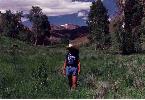
Wilderness. Again roving through gradations of ecosystems, we entered the
Mtn. Mahogany zone and saw Columbines and other flowers for the first time
this trip. A Golden Eagle flew past, and as we looked up, we saw a blizzard
of Cottonwood fluff storming along on the breeze. It's
been two days since we saw anyone, and today we saw only deer, elk, skunk,
and coyote tracks.
The Southern TH was vague and looked seldomly used.
We had transnavigated the Jarbidge, and it's
a mere 11 miles, straight line, back to the TH near the vehicle across
this, one of the broader sections of the wilderness. Although small, the
Jarbidge packs a lot into its very wild space. It's
a lot like Idaho, if you were to iron flat the Jarbidge, it would be quite
large. In heart, it's bigger
than a pompous place like Texas, richer than the Trump Tower, and it's
public land. At 6400', this trail head is the lowest point of the trip.
Roving back to camp, we watched the apex, the end of the ridge, of Marys
River Peak protrude into the Northerly skyline, smiling with a broad white
cornice. It was quite warm upon return and a dip in the river refreshed.
While eating our delectable scrambled eggs (powdered
eggs) and sausage (TVP, textured vegetable product), and toasted muffins
and bagels, I noticed movement on the near side hill. George was busy with
his gourmet cooking and Paul was busy lathering butter and jam on a golden
brown muffin that was steaming in the early morning coolness. A big fluffy
coyote had come to investigate the llamas, had now caught our scent and
was retreating from our intrusion. In my excitement, I lost my balance
on the llama pack bucket perch and fell flat on my back. I garnered considerable
kidding from George and Paul, who noted that they rarely got to see the
exciting stuff because I was jumping or falling or causing some disturbance.
It's another delightfully warm
and sunny morning in this land of opportunity.
As Paul and I explored to the South edge of the
realm, George toured the untracked areas East and above camp, while the
faithful llamas rested. George found wide elk- and deer-groomed trails,
far superior to the faintlings we are hiking, and all sorts of tracks.
Upon our return to camp, we saw the llama formerly known as Snowball (now
Dirtball). Apparently, he had enjoyed the afternoon, rolling and lounging
in the dirt.
As ducks, Sharpshinned Hawks, and Redtailed Hawks
ply the sky, we sit down to our first campfire of the trip and tell tales
of previous escapades.
 |
DAY 6: LOOPING JULY: (Marys River
Basin to West Marys River, estimated trail mileage was 7 miles, ERM was
10.) The sun pierced through the slit in the fly of George's
tent, bringing sweet dreams to an abrupt pause. Peering out, I could see
a thousand points of prisms glowing the color spectrum in beads of dew
along the slender stalks of tall grass in the prairie in our front yard.
Yahoo for public land, untrammeled public land, where we feel richer than
the fattest-cat property Barron. Suddenly, it began to snow, huge fluffy
flakes drifting on the morning breeze and through the bright sun light,
highly contrasting with the deep blue sky. Sun light?! Blue sky?! What!?
OK, it was Cottonwood fluff.
Today we hiked trail 018 from our camp along Marys
River (6800'), over the high saddles (8413' and 8485'), from which we completed
our broad loop by returning to our Day 3 camp along West Marys River (8054').
Almost all of the elevation was gained after we left the confluence of
West Marys and the Marys River, where we began hiking the ecogradations
through open slopes and basalt outcrops to the subalpine fir zone. Great
views developed of the distant snow-capped Ruby Mountains, beyond a sea
of purple-haze low ridges. The wind blew hard on and off, but, as usual,
nothing but pleasant weather prevailed. The small stream near camp appeared
to be flowing less than on Day 3, a harbinger of dramatic changes in this
island in a sea of sagebrush, I suspect. We had left camp on a leisurely
schedule, and arrived in the West Marys camp around 3 p.m., allowing plenty
of time for cocktails, a warm shower, lounging, and journal writing as
the sun set and a few mosquitoes joined us for map review. We noted that
today was July 1st, and that we have hiked solo across parts of the quads
Jarbidge South, Marys River Basin NW, and God's
Pocket Peak.
DAY 7: EMERALD BLOW-OUT: (West Mary
River Juntion to Emerald Lake, 4.7 miles one-way, 9 plus trail miles; 13
ERM.) The torrent of wind created a vacuum, sucking the air out of my lungs
and nearly stopping my plodding progress up the switchback back to the
9800 foot ridge-pass above Emerald Lake on one side and Jarbidge Lake on
the other. We had hiked from camp near the 4-way junction at West Mary
River to the 9400' pass (between the Jarbidge and Marys River drainages)
above partly-frozen Jarbidge Lake, continued up and over the 9800' ridge
and into the East Fork Jarbidge drainage and down to the pass level at
Emerald Lake (9436'). The wind would later bring a large, threatening cloud
bank which we eyed as we cooked large quantities of spaghetti, sipped wine,
and appetized on fried oysters (dipped in a powdered egg wash and dusted
with blueberry pancake flour prior to cooking - what a great idea, George).
Perhaps the weather is preparing for the July 4th festivities. As they
say in Montana "if it's
Summer on July 4th, we'll have
a BBQ."
We mused about how the route East of Mary's
River Peak (trail 099/200) was completely under snow, how the pass above
Jarbidge Lake is OK from this side, but little fun from the Jarbidge River
Trail because of lingering snow banks - although I have walked into this
area twice before during the same time of June - or a little earlier, and
how it's been 4 days since we
saw anyone else. Local sunset arrived and we caught a few more whiffs of
sage and mint, occasionally mixed with fresh pine scent in this Class 1
airshed. Ahh, we sit back and review the deep green color of Emerald Lake,
complete with its own iceberg crowned with twisted green sprigs of avalanche
debris. Small Brook Trout slowly swam looking for dinner, and we wondered
how they survived in what appeared would be, in Winter, a totally frozen
lake.
DAY 8: TIRED DEVIL, OR, REDNECK CAMELOT:
(West Marys River to Pine Creek CG; 8 miles; 10 ERM.) We knew, and
dreaded it nonetheless, that it was bound to happen. As we approached the
(now gone) Perkins Cabin junction, we saw the tents. Oh no. After nearly
5 days of seeing no one else, there was a sure sign of people. We met two
hikers shortly after arriving at the junction, but that would be it until
we saw the relative throng of dust campers at the TH. These dust campers
had set-up next to the road, breathing in that dust- and ATV oil fume-laced
air in this Class 1 airshed, many recreating by repeatedly driving up and
down the main street of Jarbidge on those most despicable of vehicles,
the ATV ecotrasher, from their gigantic or more modest RVs
to a dusty promenade, and back. It's
normally very quiet in Jarbidge, but it is, after all, the 4th of July
weekend. I am always amazed at how great and deplorable an impact even
one of these ecotrashers has, even on a street.
This prompted me to recall the country song which
goes something like: it's a redneck Camelot...it ain't
home until you take the wheels off; it ain't
home until it's
up on blocks... it's a redneck
Camelot..." You'll have to hear the song and witness the glut of winnehogos at times like
the fourth of July to get the full flavor of this reference.
The day began with "chemicals,
chemicals, I need chemicals"
(find this famous morning mantra in Ed Abbey's
The Monkey Wrench Gang). As we drank our morning concoction of coffee,
cocoa, milk powder, whatever, our breathes left long vapor trails. It was
cooler than usual here at West Marys River, more like the coolness of the
Jarbidge River aspects. We packed, loaded the well-rested llamas and, accompanying
Alfie, Snow (he's a bit cleaner
today), and Cicero, hummed a tune as we headed over the low pass and down
the Jarbidge River to town, relishing our last bits of solitude. In Jarbidge,
we went to the Red Dog Saloon, dodging the air-contaminating ATVs. The
power was out, so we went to the Tired Devil/Outdoor Inn, where the power
was also out, but where they were cooking with gas. And, we found that
quaint bar with the devil holding the naked women. How wonderful. (My 1988
report was in error, the devil is at the Tired Devil/Outdoor Inn, not the
Red Dog).
Then, we endured the long drive home and the customary
shuffling of equipment, driftily dreaming of our stroll in the mystical
Jarbidge Wilderness. Please speak quietly, if at all, about the Jarbidge.
Where? Never heard of it. It doesn't
exist. Please check your spelling, you're
probably looking for Drawbridge, Wisconsin, it's
out there in the mid-east.
|
Wild Vagabond Main |
Trip Report Index |
Caveat |
|---|
| |