
(Click the image for a full-size view (60k); Photo by Jim)
|
|
|---|
|
Rob on Prospect Peak
(Click the image for a full-size view (60k); Photo by Jim) |
Jarbidge is a Shoshone Indian word, "weird beastly creature." According to Native American legend, Shoshone warriors chased the creature into a cave in Jarbidge Canyon and blocked the cave with rocks. The Jarbidge Wilderness is 64,000 acres large and was established in 1964. It is administered by the Humbolt N.F. To contact the Jarbidge Ranger District, Buhl, call 208-543-4129. It's best, in my opinion, to hike this area in the early summer. But, call before you go. I called in mid-June of 1997, and the area was still snowed-in.
Day 1: Straightline to Stateline (SLC to Salmon Falls Dam): Lori Neumann and Jim Sinclair arrived in their rented car about noon. I added my camera and other delicate items to the pile in my car and we all headed to REI. We would be driving two cars all the way to the rustic town of Jarbidge, Nevada. Hot already, an omen of what was to come. Then, after REI, we ate lunch at the Rio Grande (very calm this time of day on a Saturday). Eventually on the road and headed across the straight line of the salt flats to the state line of sin. Wendover, Nevada. We paused to walk out on the salt flats a few miles from the site of the Bonneville land speed course. Strange texture to the salt plain, and the residues burned my feet and clung to my sandals. Even though we were not out long, and there was no appreciable wind, a film of salt-laced something could be detected by the skin irritation and a lick of the skin. To Wells, then N to Jackpot where we roamed the casinos. Lori wanted to experience the gambling, and we thought we would find a decent and cheap place to eat. What a cacophony. Lights blasting, buzzers and gongs blaring, the amplified sound of money dropping into the slot reward bins. Just like a white rat in a Skinner box, responding incessantly to the intermittent partial rewards. And who says behavioral principles are not valid for humans? Clearly a pop-tart mentality prompted this irrational view. Finally on to Rogerson, ID, where we turned toward the Jarbidge. Entering the Rogerson townsite from the S, take the second and paved left turn. Just past the picket fence, you can't miss it. (Have you heard this before, just prior to getting lost?) Very dark by now, we continued on another 6 miles to the Salmon Falls Dam BLM (Bureau of Leasing and Mining) camp area and crashed. Warm night, the low would be 50.
Driving Summary: After the world overpopulation surmounted 6 BILLION, I removed the driving summary.
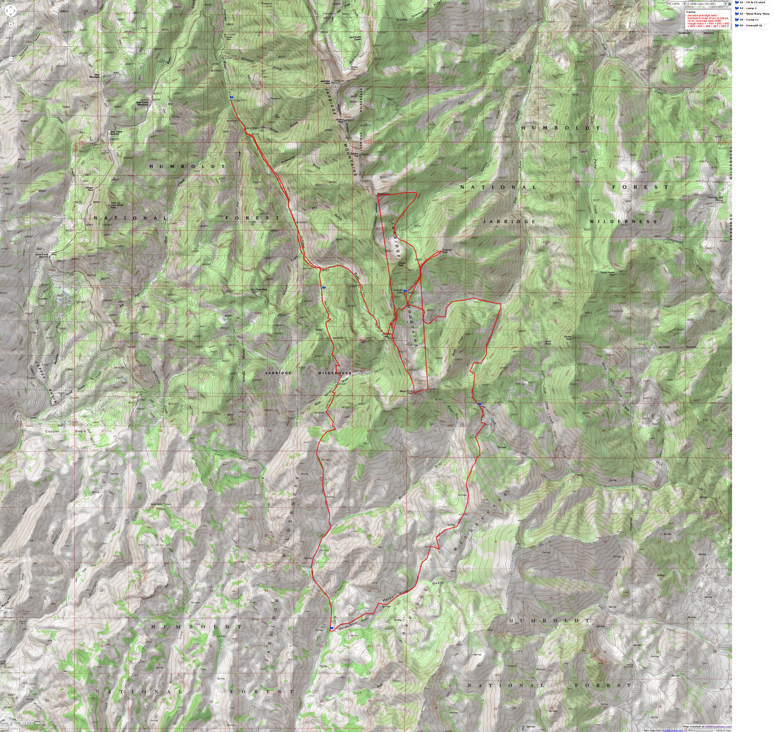
Map Summary: I went to the USGS office in SLC and found that the 15' 1943 Jarbidge quad has been replaced by two 1986 7 ˝' provisional quads: Jarbidge South & God's Pocket Peak. Below these quads are Marys River Basin NW and NE, 1968. Some of the human-related features on the 1943 map do not appear on the provisional maps. This may be because of changes in the status (e.g., Norman Mines) or existence (e.g., Perkin's Cabin) of features. The F.S. literature notes that there are 8 peaks over 10,000' in the wilderness. However, I counted 9 such peaks: Jarbidge, Jumbo, Square Top, Matterhorn, Cougar, Prospect, Marys River, God's Pocket, and Divide Peaks.
Day 2: West Fk. Jarbidge: Into the wilds; stove run: We drove up and over to Murphy Hot Springs for breakfast. Along the way we passed turnoffs to Three Creek and then Pole Cr. R.S. (separate roads). Stan and I had entered the Jarbidge Wild from the Pole Cr. access in 1981. We were treated to views of the big peaks propping up the sky. Looking down the dusty road ramp into Murphy afforded wonderful views up canyon of the forks of the Jarbidge bathed in the low-angel light of morning. Mystery no doubt hid in the shadows of the canyon depths. A shower to remove the salt slime, then pancakes. Great quaint place. Some of the residents appeared genuine old west. The tableware was an assortment of pickle forks, silver spoons, and heavy beige-gray coffee mugs which had originally been white. A dip in the hot pools was reserved for after the hike.
Leaving Murphy Hot Springs, the road became much narrower as it snaked down the East Fork and then up the West Fork. A dusty one-track, maximum speed was about 22 mph. Visibility is so restricted, and the course of the road so erratic that one can rarely afford a glimpse of the towering rhyolitic canyon walls. We found George Urdahl out inspecting campsites South of town, and learned something about his 53 years as a seasonal F.S. employee, but little about the conditions in the backcountry (he has spent very little time in the wilds). A beer at the Red Dog Saloon was a big mistake, because we were all quite bombed for the next hour or so as we attempted to get our feet on the trail. Of course, I signed in the Smegma Brothers from Big & Hung, Utah at the trail register. 4 p. and we're on the trail from the trailhead (6900') at Snowslide Gulch about 3 miles S of Jarbidge. Lightning occasionally crackles and some light rain sends us hiking up the old road. Lupines everywhere. Other flowers too, in particular the field of mules ears offering a grand foreground to the lazy side of the Matterhorn. In a couple of miles, we reached the location of the now nonexistent Perkin's Cabin (it's on the 1953 15' map, but not the new provisional 1986 7 ˝' series). From here, the left fork continues up the old roadbed, becoming a trail which eventually crosses the ridge line between Marys River and Cougar Peaks and into the Emerald Lk area. The right fork goes up and over a pass, entering the West Marys River area. We took the right fork and gained altitude quickly for a mile before stopping for the night. Occasional rain hurried our attempts to locate a suitable tent site. Everything was on an angle. Then the unpleasant discovery, no stove. Jim had left the stove in his cook pots in the car trunk. I put on my trusty, and very old, Nike Daybreaks and trotted back to the car. Heavy rain at times, but warm. At the car, I gobbled a couple of cookies and a twizzler before returning to camp. A cool handkerchief bath preceded dinner. Calm and dry now.

| ||||
If you want to view a full-resolution map, click here. Caution - do not use this map or gps track for navigating the route.
Day 3: Flower fantasia: To Junction of West Marys and Marys Rivers: The incredible fantasia of flowers continued. During the epic we would see: lupines, mules ears, arrowleaf balsamroot, purple fringe, paintbrush, heartleaf arnica, hookers onion, phlox, buckwheat, columbine, goosefoot violets, forget me nots, shooting stars, alpine gold, monkshood, sticky asters, and numerous less showy flowers which we did not know and could not identify. We were obviously at the peak of the brief flower season, and many flowers in the lowlands of Marys River Basin were on their way out. We puffed up and over a low pass into the West Marys River drainage on this longest day of the year. Hot today, and we encountered only a few remnants of snow banks on the trail. From the pass we drifted in and out of timber to the open areas below. Puzzling where the trail to the W went, it appeared to go straight up the peak or ridge line at the head of the drainage. We later learned that it connects with the trail coming up to the Emerald Lk. area from Perkin's Cabin near Jarbidge Lake. Continuing toward Marys River Basin, we left West Marys River and headed over a low pass. Dropping through picturesque rhyolitic swales, we burned up the film on wildflowers and rock. Down through the ecosystems we tromped, a unique aspect of the Jarbidge wild. It seems that you're either going up or down. This country is not very large unless you think in terms of ironing it out flat. Much like Idaho. If you were to iron Idaho flat (why would anyone want to do this!?), it would be larger than Texas.
We camped where the West Marys (coming in from around the land bump we had hiked across) meets Marys River. It gets a bit confusing, because it looks like a stream labeled "Marys River Basin" joins Marys River just upstream from the confluence with the West Marys. Actually, it appears that the "Marys River Basin" flow is the E. Fk. of Marys River, and all three Marys Rivers flow into the area termed "the basin." A cool and refreshing, albeit thought-stopping, shower quickly revived us. "Are you frigid?", asked Lori. "No, but all my thoughts have stopped," I replied.
Day 4: Jarbidge Juggernaut: Off route in the Jarbidge: To near Camp Cr.: It's fairly open and dry here in the lowlands of the Marys River Basin. A different type of vista presented itself as we easily forded the river (three times instead of the six depicted on the map) and hiked upstream along Marys River. Volcanic style cliffs and outcrops here, while the higher elevations appear more peak-like where much of the rock seems to be of metamorphic/igneous origin. I nearly stepped on a garter snake during one of the stream crossings. Heart failure. Then, we started the climb to the divide separating Marys River and Camp Creek. We passed through two hunters' camps decorated with deer antlers, gallon wine bottles, and mutilated aspens. Both these camps altered the visible trail route, and the second one pulled us away from the direction we should have been heading. Somewhere near the upper tributary of the E. fk. of Marys River we went off route and wandered into the tributary spring area. "Off route" is somewhat of a misnomer, because there was little of the route in the first place, and what was there was often obscured by the dense field of lupine. It didn't take us long to realize that we were no longer going the right way, although we were briefly puzzled by the apparent correctness of features surrounding where we were. Fortunately, we had sense to consult numerous sources of information (altitude, direction of spring flow, compass headings) before hastily concluding to hike over the next "pass". By this time, however, it was time to establish camp rather than sleuth our error.
While Lori & Jim set up camp, I took the maps, compass, and altimeter back to the last known thread of trail to find the route. Wading through fields of fragrant lupines, I was happy to wander around for a few minutes before getting down to business. From the knoll near the last vestige of trail going N (the assumed correct direction), I sited on low peaks we thought we knew. Soon, it became apparent that there were two knolls which lie on the same compass line, and that there were also two low peaks with parallel headings to this line. Closer inspection of the map, and comparison with compass and altimeter readings (which had been difficult to rely on because of the passage of small building thunderheads) helped me determine where we should have gone. Carefully laying a course, I headed to where a benchmark was indicated on the map. Where's the trail I should be on? Nonexistent. I found the benchmark, then a large Basque-type cairn on the second knoll and figured out the route the trail was supposedly on, but there was no trail for a segment. We actually had a better campsite that if we had stayed properly on route. Throughout the day we had observed several aspens carved with the message "Jose Antonio Elega". Jose had been in our campsite in 1954. It attempted to rain on us near sunset, but with little success.
Day 5: Crashing down the East Fork: To the junction of the East Fork Jarbidge and the fork from Emerald Lk.: Back on route and headed for approx. 9800' and a pass near the head of Camp Cr. The trail was a bit vague after the benchmark, then OK to where it dropped into the head of Camp Cr. The trail was vague (and unsigned) at the intersection of the Camp Cr. and our trail, but we easily figured it out because Jim had been watching his altimeter (Jim recently bought one of those electronic technologically-heavy ultimeters). Pausing for lunch at this junction, we noted evidence of a transitory Indian camp. The clues were obsidian flakes, two partially worked points, and vestiges of an old campsite. After lunch, we paced to and located a benchmark. We knew exactly where we were. Amazing. This must rival the discovery of the meaning of life. Continuing, we passed another junction with the Camp Cr. trail (a tiny portion is on the 1986 but not the 1968 maps, where we had just walked on to the God's Pocket Peak quad). The trail became a bit more visible at this time as it ground to the pass above the E. Fk. Jarbidge. We joined the Stan & Rob 1981 route at the junction where the trail from Hummingbird Spring (near Pole Cr. R.S.) intersects with the trail coming up and then over and into the East Fk. We had wondered what the Marys River Basin was like. We thought we could see glimpses of the basin from the pass, and wondered. I recall looking down the Camp Cr. way and thinking how luxurious a hike it appeared to be. We would be on the 1981 route to Emerald Lk. From here, Stan & I had climbed Cougar Pk. and departed down the Cougar Cr. cirque to complete our quest.
Down into the East Fk. drainage, it wasn't long before we were required to pick our way through avalanche debris. Then, very old debris. After awhile, I realized that this clog had existed in 1981. Great trail maintenance. The F.S. is obviously spending its budget on lobbying for timber sales and roading wilderness areas. Finally detouring around the lower segment of the clot of trees, we returned to the infrequently traveled trail where it crosses the creek. Twisted ankle, what a bonus. We felt as though the trail had been abandoned. Perhaps a new trail has been built which skirts the slide area and continues on the other side of the canyon. No. On and on, and despite our fairly light packs we experienced flat feet. Dropping quickly off the nose of Slide Ridge, we arrived at the ford of the fork coming down from Emerald Lk. Now I remember this. We camped on the Slide Ridge side of the ford after locating a rare sandy pocket about 150 yards upstream from the trail crossing. Jim and I found a place where we could jump across and went to inspect the sign at the junction:
| Emerald Lk. Trail | E. Fk. Marys River Trail |
| Emerald Lk. 4.5 | <-- Slide Cr. 7.0 |
| Jarbidge Can. Road 110.3 | <-- Pole Cr. R.S. 13.7 |
| Camp Cr. 4.5 --> | |
| Hummingbird Sp. 12.3 --> | |
| Marys River 14.5 --> |
After a brain-freezing bath, we ate a luscious dinner and started our 10 hrs. of sleep.
Day 6: Prospecting for peaks: East Fk. junction to Emerald Lk.; climb Prospect Pk. (10,439): From 7600' at the junction, we would grind to near 9400 at Emerald Lk. and continue to the height of Prospect Pk. Another clear day, and warming rapidly. Up and up, mostly across open slopes dotted with occasional thickets of aspens. No people yet, this would be four full solo days today. Partial bits of memories fluttered through intermittently as we gained the Emerald Lk. cirque. Shooting stars (wildflowers, that is) ringed the bermed ponds near the junction of the trail to the pass over Marys River Mtn. ridge and the trail to Emerald Lk. and on to Cougar Cr. What causes these berms? Ice movements? There were some small cutthroat trout in Emerald. Yes, it certainly is a glacial-powder turquoise blue. We located a campsite on the low "ridge" at the NE end of the lake. Fairly well protected, it would do.
After partially establishing camp, we headed up the interstate route to Prospect Peak. What sort of volcanic (?) granules is Prospect made of? Great views of Marys River Mtn. and much of the E. Fk. drainage, some of Slide Cr. and the Cougar cirque, then far to the East to Biroff Ridge (near Hummingbird Sp). The low-angle rays of the sun pouring over ridges below made the Douglas Fir look like two-dimensional fans silently fanning the yellowing light. Grand vistas of inner earth.
We had been in shirtsleeves all day, but pants and jacket were required after a late dip in the lake. There was much less snow in the Emerald Lk. area than either Jim or I had encountered on previous trips. Just a few dwindling snowfields remained. In 1982, Jim reported that the trail was covered with snow over the July 4th weekend. I believe Gaylon Lords and the Scot, John Crumlin, were along on this hike. Long days, we got to bed at 11 p. The overnight low was 45.
Day 7: Mary, Mary: Dayhike Marys River Peaks 1 & 2. Arising late, we left camp in place and headed up the trail to the pass separating Emerald and Jarbidge Lks. From above, we saw our first people of the trip. Two hikers and two pack-wielding dogs came struggling up from the depths of the E. Fk. We hiked to the pass and then continued the trudge along the backbone of the ridge leading to the talus two-step up Marys River Mtn. We received a great deal of UV rays on the way up to the summit. A few mountain bluebirds greeted us near the summit. Looking down on buteos! It would be great to glide the hills like one of these big raptors! I logged the Smegma Bros. into the summit log and added a few comments about the mission of the F.S. The map and the USGS benchmarks don't agree on where Pks. 1 and 2 are, but I trotted over to #2 (according to the map) anyway. From here I could see most of the pass into the East Fk. from Camp Cr. It's a small world, after all.
We slowly returned to camp and found two day hikers fishing in our lake. We ate mac & cheese between blustery but mostly toothless storms. One bout of hail and an electric show enlivened the early evening. Is there an impending weather change? Quivering barometers, posing as altimeters, suggest that this is the case. Returning wet in the natural state from a handkerchief bath, Lori and I burned an extra amount of calories standing motionless in the cool breeze while a deer circled us and camp several times. A sallow ˝ mood peeped through the cloud cover near sunset. Another mild (49) evening.
Day 8: Marauding the Matterhorn: Dayhike to Matterhorn (10,839): Early we had a gray sky and it looked like a stormy day, but soon the sun came out and the earth warmed quickly. I took the top pocket from the Lowe and fashioned it into a fanny pack. Jim and Lori packed for a hike down Cougar Cr. We walked to the Cougar/Prospect pass and down the other side a bit before taking separate routes. I went off route heading around a contour toward a buttress leading to the Matterhorn, while Lori and Jim continued down canyon towards the old cabin in the cirque. They found Ron Watter's ancient signature in the falling down cabin. I had to drop a bit more altitude, to 9000, before heading up the ridge. The bottom segment of this buttress is the only difficult piece of the climb (a bit unstable). I surprised a deer hiding in a scrub clump, and he burst out and nearly produced cardiac arrest in me. I found a remnant of an old cast iron (full size!) stove on the ridge just before the summit pull. Amazing. There was also evidence of prospecting - pits. Staying on the gentle West side, it was an easy scramble to the top. Ladybugs. A whole bunch on the summit, but I don't recall seeing them anywhere else. I found an old jar with an entry from a 1956 USGS team and someone from Japan in 1978. Great views of Square Top, Jumbo, and Jarbidge to the North. All lie on the same ridge line and could be knocked off in a day. I had contemplated returning via the ridge route to above Emerald Lk., but had my plans changed by an incoming storm. I got off the ridge quickly and began the ramble back to the trail. Along the way, I found an outcrop of conglomerate with a few geodes. Nice find. Plodding back up to the pass and then down to camp, a strong wind blasted and buffeted me all the way.
My trusty retired running shorts were in tatters, and one could easily see through to the upholstery. Toes protruding through the olefin socks, and threadbare wool socks complemented the hiking attire. Time to replace equipment? Perhaps. Somehow, my water filter has managed to become partially plugged. More woes? No, actually markers of numerous fine expeditions. We're nearly out of food, and our already light packs will be floating us down the Jarbidge on the way out.
An incredibly frigid shower was "enjoyed" by all. Gusting winds, cloudy skies, and plummeting temperatures all contributed to the experience. Builds character? Will make a man (woman) out of you? Well, I suppose if you're a man, this sort of experience will hasten the departure of the testicles to somewhere South of Cleveland, or North of the beltline. And for women? So much for impending storms, because the evening closed with a gold hue on Gold Knob.
Perhaps we could make a figure-8 in the Jarbidge. We could hike in a cache to near Emerald Lk. or some other natural crossing point, continue the lower or upper loop, return to the cache for resupply, and hike the other loop. One possibility would be to link the 1981 and the present routes with this cache-and-hike approach. In this manner we might enjoy more normally-shaped feet because of lighter packs, and extend our time and enjoyment of the wild. Hum.
I read a bit of Ecodefense (2nd Ed.) by Dave Foreman while Lori read sci-fi, and Jim studied the flower guide. Long photo periods make for better lounging.
Day 9: Jarbidge Jump Start: Early for us, we had little difficulty stuffing the dwindling food bags and other equipment into our packs. It's not really time to leave, is it? Well, at least we have a normal day's hike to Snowslide Gulch ahead of us. Up and over the Marys River Mtn. ridge and switchback down to the pond-sized Jarbidge Lk. Deeper forest here, and more evidence of mining. We paused at an old line cabin leaning downstream. The walls were stylized by flattened Lucky Lager beer boxes. The traditional decor of the era, no doubt. Passing back through ecosystems, we crossed several times then joined the abandoned road that leads to this cabin. Soon after joining the scar, we arrived at the Perkin's Cabin junction. The loop is complete. Rest the tired feet before continuing to the trailhead, seems like a much slower pace now. Is this anticipation? Well, there are cookies in the car. But, then again, there's golden Wyethia (mule's ears) in them there hills.
The springs flowing over the road cut near the trailhead had nearly stopped flowing. George Urdahl was sleeping in his F.S. truck at the trailhead when we arrived. I suspect he had been waiting for us. Hot now, we roasted in the now unwelcome UV while talking with George about "just how it was". It was great.
We ate a late lunch (4 p.) in the Traveler's Inn in Jarbidge and briefly examined the exotic bar. The bar counter pillars were two life-sized devils holding thrilled naked women. A scene out of the noisy days from Jarbidge's past? With a long drive ahead, I declined the opportunity to stop at Murphy Hot Springs (I would have been noodlefied) and headed for Twin Falls. A long slithering drive along the Jarbidge to Murphy, on pavement again (the most dangerous part of the trip, no doubt, is driving with texans and utahans on the open road), and into a shaker of a thunderstorm in the Idaho Brunea desert. A long look back revealed lofty peaks (the elevation is striking from the East side) disappearing into humongous black anvil clouds. Looks like Lori and Jim are getting their ears washed. At one point, I thought I was having an out-of-body (or mind?) experience before I realized what was causing the "thump! clack! twang!" in front of my face. Crickets were thumping off the car like invisible large hailstones. On and on, more freeway on this route and a bit shorter. At sunset, the sky was painted that color crayon pink and saffron, reminiscent of the giant red paintbrush in the wondrous Jarbidge Wilderness.
| ||||
If you want to view a full-resolution map, click here. Caution - do not use this map or gps track for navigating the route.
|
Wild Vagabond Main |
Trip Report Index  |
Caveat  |
|---|
