 |
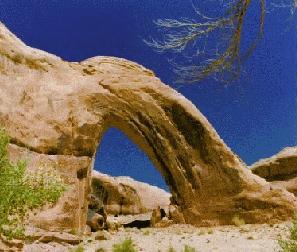
| Broken Bow Arch in Willow Gulch (photo by Bob Fagley) Click HERE for full image (717 X 910) |
|---|
|
|
|
SUWA main page - http://www.suwa.org/ |
|
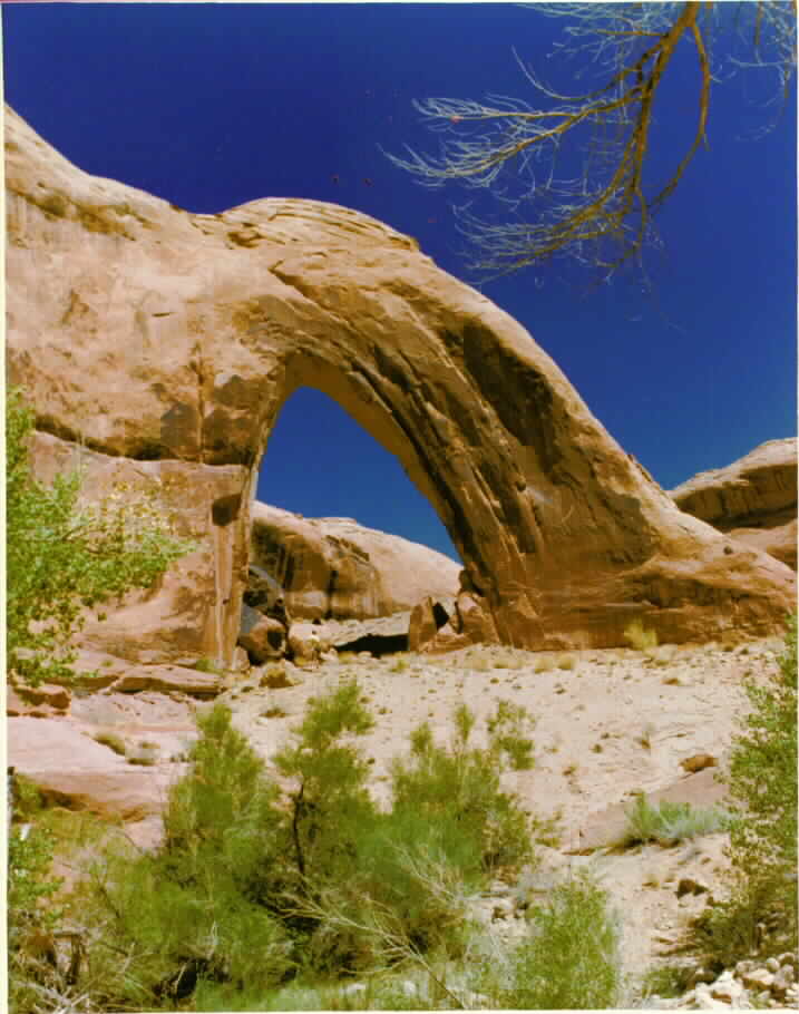
| Broken Bow Arch in Willow Gulch (photo by Bob Fagley) Click HERE for full image (717 X 910) |
|---|
We ate at the Cowboy Blues and bumped down the Hole in the Rock Road, pausing at Dance Hall Rock and Carcass Wash (where 13 scouts and leaders were killed 32 years ago to the day, today (how cosmic!) when the truck in which they were riding stalled on the grade and rolled into the wash).
Just beyond Carcass Wash, we encountered Sooner Rocks, pillows of deep red Navajo Sandstone floating on the parched Escalante Desert bench. Here we located a nice camp area and erected the screen tent after a few false starts. It s a cool (relatively) day and quiet. The rangerette said it would be quiet "because it s getting deathly hot down there." The cactus and yuccas are in full bloom on the higher portion of the Escalante Desert, while it appears that those on the lower areas are past their flowering, reduced to desiccated crispers of their former forbulant selves.
Day 2: A Hole-in-one: (To Hole in the Rock and the big sewage pond.) It was a fairly cool night and it was difficult to get up today because it was preferable to relish the desert quiet and languish in the soft relief of the morning light.. We loaded our precious water and drove to near Cave Point, where we started riding mountain bikes for the approximately 10 miles to the top of the big cleft in the Navajo Sandstone called Hole-in-the-Rock.. It truly is a 4WD route part of the way, starting about 5 miles from the hole. We passed a Honda Accord at the bottom of one of the slickrock patches after crossing several scorched-on tire marks and fresh metal scrapes on the slickrock bumps, and we later encountered the owner - sleeping bag slung over his shoulder and walking fast. He noted that he was worried, asking "did you see any oil leaking out of my car?" Yes indeed, it would be a long, dry walk from the hole to get help. We arrived at the gash just as some boaters were hiking up. They wondered if we would be riding our bikes down the rock gash (how silly). We hiked down the slot, admiring the steps cut into the sandstone. It was getting genuinely hot as we went for a cosmic swim in the big pond - delightful and refreshing. Some house boaters came by and their rental boat was stacked with kayaks. Sea kayaks. Their story about trying to locate a non oil-laced raceway away from the chainsaws on water and the tin can tourist crowd was disappointing. Perhaps a sea kayak trip would not be much fun, especially this time of year. Then we hiked back up, where we stopped in the rare shade of the trench for lunch. It was a very hot return bike ride. We drank all water bottles and 3 quarts, then 3 more quarts each upon returning to the van.
We drove back to Hurricane Wash and filled 2 bwana bags for showers (at a tap from a stock pond), then returned to camp to wash and lounge. There were 4 cars at the Hurricane TH and we saw 4 other vehicles today. What a glorious, self-actualizing day riding the slickrock and hiking the slot. We relished cheese, stew, and tortillas while watching the minus one day full moon peek into the saddle of one of the Sooner Rocks. It s cool and enjoyable now as we soak in the gathering gloom of this very silent desert. I had signed-in at the hole registry as Idaho Joe Smegma and added the comment "wild country, warm women, cold beer, and a song." Sing this 3 times....
Day 3: 40-mile/Willow Gulch & Broken Bow Arch: I found myself absently watching the lizards and Chat (?) while listening to my heart beat, sitting at the portable picnic table sipping mocha. It's so quiet your eardrums sing to you. Life is tough.
Today we walked cross-country for about a mile from the Sooner Bench Road and into 40-mile Gulch on ancient chiseled steps. It was getting very warm as we traversed the titules and brushy plains. After some scouting, we found the unmarked route into 40-mile Canyon and then a wondrous cool arc of the canyon in which to rest. Down and narrower, we encountered a very aggressive bull snake who hissed and coiled at our passage. She acted like she wanted a chunk of Brent's leg. More narrows, a deeper canyon, then wading and some stemming over the water - a very delightful jaunt and much cooler down here. We encountered a flock of crayfish, tiny fish, and tadpoles. Hidden Corkscrew Falls appeared suddenly below and we skirted the overhang through a tangle of poison ivy. Excelsior! - coolish water screwed down the sandstone slot while little fishes nibbled on my toes. A good place for lunch. More narrows and easy walking with little brush to the junction with Willow Gulch. We met 3 mismatched boater buffoons - 2 short and dumpy egomaniacs and one tall "hey man" dude going up 40-mile near its mouth. Hey man asked "Is this the way to the arch?" We corrected, then the dough-people began giving us directions. They seemed no more connected to the inner cosmos then the unknowingly lost BLM "recreationists" driftoids of lower Dark Canyon (see the BLM Bonehead Bonanza in the Dark Canyon/Horse Pasture trip report). It was a case of the unknowing advising the unwilling and ungrateful in an incongruent and divergent manner.
We broke free and continued down the main gulch to the stagnant waters of the big pond. No log jams, so we waded out a ways, then climbed up on a bench to observe this "recreationists dream." Back up canyon, and up Willow Gulch we found more brush and boulder hopping.
The arch was a flying buttress delight. A mile or so above the arch we were slogging the sandy wash and avoiding a playful narrows before sand-chute walking to the mortar board feature and the parking area. The mortar board feature is how to tell where to go up from or down into Willow Gulch. It had been a long day and we found 40-mile Gulch the more spectacular of these two wondrous ventures (probably 9 miles and a leisurely 10 hours).
Our camp was thankfully in the shade of Sooner Rocks and tamarisk by now. My faithful Donner boots blew out and let millions of rocks in to my feet, not to mention the tiny fishes nibbling on my toes. I would be required to permanently retire them.
Day 4: Miles and miles of 50-mile Mountain (Kaiparowits Plateau): Window Wind Arch, Straight Cliff: Seeking to once again elude the desert heat, we drove just west of Hurricane Wash TH and to the TH for the hike up the Straight Cliffs to 50 Mile Mountain (more a haphazard and very long bench of the Kaiparowits Plateau). If you go - beware of route false starts. We wandered sage toward the ridge in the bay of the cliffs apparently marked as "pack trail" on the map, but not the ground.
Note: the real route goes east from the corral, quickly crosses a shallow gulch then wanders up to the high medial ridge leading to 50-Mile Bench (there are two drainages, not one as it seems on the map). The route is not at all obvious at first but becomes more prominent as it climbs the ridge apex, heading straight to the bench.
We took what we now know to be the west ridge and encountered a seemingly insurmountable rock band. After reconnoitering, we scrambled up. Wow, fossilized oyster beds galore. I brought back some specimens. Cutting back to where we now saw the trail because two flogged backpackers were descending it, we deposited the treasures in a "den of antiquities," accompanied by a dozen squadrons of no-see-um gnats and headed up our new-found trail. Continuing across 50-Mile Bench, the trail zigged east and away from the cleft, then back as we went sharply up and around, zagging through the rock bands. Into scrub oak and Pinyon Pines. It's still very warm but much cooler up here than down there. On 50-Mile Mountain we walked out a short distance and found the pack trail, then along it for 1/4 mile or so, where we saw a distant white wing of sandstone peeping through the pygmy forest. There is no real trail, but this is where the arch is. It probably can be seen from the road, near Big Hollow Wash, I'd guess. Then, after lounging under a Pinyon, we went back down in a couple of hours. Coolish water from Willow Tank (a spigot from a cistern at the Hurricane Wash line shack, near the Hurricane Wash TH) provided a soothing and refreshing shower back at camp. Delightfully, we enjoyed dinner in the sacred screen tent - no bugs here. It feels good, but there is a certain difficulty to describing the primal connection of hiker to the desert. Whatever it is, it's accompanied by the very quiet and solitude.
Day 5: Nearly Henry: We packed, leaving our lovely Sooner Rock home, and headed back up the ever-warming dust track to Escalante. Somehow, the rear door of the van was ajar, thoroughly dusting our equipment.
We replenished ice, etc., and ate lunch in Escalante, then drove toward Posey Lake from the forest road at the SE edge of town, and on the Hell's Backbone Road. Wow - this is where the lower and upper accesses to Box Canyon are, and far above, the access to Box Death Hollow. The terrain is like a big anticline, parts look like checkerboard mesa. The road goes up and up to 9200' near the backbone bridge, a thin trestle between two gaping white rock abysses. Then, down and down to intersect Hwy. 12 near Boulder Town. From Boulder, we drove around the edge of Boulder Mountain and past a few accesses to the Great Western Trail. There are tiny remnants of snowfields here. Then, back down to the heat near Torrey and through Capitol Reef N.P., and the moonscape beyond, and into Hanksville.
The grazer at Escalante BLM had known nothing about the area and didn't even know when the Hanksville office was open. It was closed. We headed down the dirt/gravel road "access to Henry Mtn. RMA" straight south from Hanksville. The road is flat for about 10 miles, then it goes up and up for about 11. It was OK for the first 17, then we encountered a stream crossing that Brent did not feel comfortable about. We backed up and camped a few hundred yards back from the crossing in a lovely monotone of Pinyon Pines and cool winds. Will it rain, or just blow? Along the way, we encountered a family of three badgers shagging along on their spiked heels. What lovely creatures, they grinned at us.
Day 6: Ravaged by Ellen: We biked nearly to Bull Creek Pass, then climbed Mt. Ellen at 11,506': It was a good camp in the pines, but too windy. Besides, we wanted to explore the 4WD route around the south ridge of the Henry Mtns. (as described in the Mt. Ellen description in "The Mtn. Bikers' Guide to Utah" by Gregg Bromka). So, we moved camp to Lonesome Beaver CG at about 8200' across 2 stream crossings and up more elevation. The 10-site CG is old and it was deserted. It's nestled in a cornucopia of trees - firs, aspens, Mt. Mahogany, and others - and its fairly well sheltered. We enjoyed lunch in the cool camp, such a contrast with the last few days. By 2 p., we had set-up camp, lounged for lunch, and prepared for a reconnoiter.
Up to Wickiup Pass we biked, then on to near Bull Creek Pass at 10,485', a 2285' climb in 4 miles. I say "near," because snow banks prevented farther progress. We changed boots and approached these laccolithic intrusion triple E-cuppers on foot. Not that it was much faster biking this last bit than hiking, but we were planning for the return trip, when we would drift down on wheels, not slog down on feet. Only two stretches of snow and a couple of turns in the road and we were at the Bull Creek Pass.
The wind preceded us. On toward Mt. Ellen we hiked, about a mile and a half of wondrous, albeit sometimes tippy, rhyolite spangled with lichen and we were up another 1,000'. The wind was now a ravaging gale, probably at least 60 MPH, perhaps 100 at times, in which it was difficult to breath. It's a long summit ridge and we nearly quit before the highest point. But we found the top bump, replete with a pink flamingo and a mail box. We signed-in and headed down. My feet were knocked off-course on several occasions by the gargantuan gale.
Flogged and a bit dizzy (from wind and/or altitude?) We reached the bikes. The trip down was a hand-gripping 25-minute ride. Quite a reconnoiter. It was cool but mostly calm in camp and I'm finishing this entry by lantern light, wearing pile jacket, pants, and such. I added a staccato of lumps and cuts to my right leg when my foot slipped out of the toe strap on the speedy descent today. My hands are still a little numb, but I'm not dizzy (as far as I know). It is cool enough to avoid a shower. Upon reviewing the map, I see that the North Summit Ridge is actually higher (11,522') than Mt. Ellen (11,506'), so I wasn't crazy or totally anoxic after all - when I thought that we were at the high point on the ridge and the mailbox on the E-cup was at a lower elevation.
Day 7: Blown Asunder: Overcast and pile jacket cold, we drove down, ate in Hanksville (Tropical Jeems is looking permanently closed), and went into the San Rafael Reef and Swell area via I-70. We planned to camp near the river and ride to The Wedge Overlook, but we were nearly literally blown out of slickrock orbit. The temperature was desert ideal, but the wind turned your mouth into a mud bowl if you opened it. We blew out of desert orbit. It was a slightly premature end to a great trip.
It was cool in SLC and sadly I didn't get on the permit for rafting the Grand Canyon with Roger Christensen. And sadly, Smog Lake did get the Olympic bid for 2002. There goes the neighborhood. Industrial propagation is the utah state moto, argh :-((
|
Wild Vagabond Main |
Trip Report Index  |
Caveat  |
|---|